Saturday, April 20, 2024


Surf clams off the coast of Virginia reappear – and rebound


Rutgers scientists point to improved environmental conditions as possible reason


RUTGERS UNIVERSITY

Gathering clams 

IMAGE: 

MEMBERS OF A RUTGERS UNIVERSITY RESEARCH TEAM COLLECT SURFCLAMS FOR A STUDY.

view more 

CREDIT: D. MUNROE/RUTGERS UNIVERSITY


The Atlantic surfclam, an economically valuable species that is the main ingredient in clam chowder and fried clam strips, has returned to Virginia waters in a big way, reversing a die-off that started more than two decades ago.

In a comprehensive study of surfclams collected from an area about 45 miles due east from the mouth of the Chesapeake Bay, Rutgers scientists found the population to be thriving and growing. A likely reason could be that environmental conditions improved, and another possibility is that the clams adapted, the scientists said. The report, published in the science journal Estuaries and Coasts, details the characteristics of a population of healthy-size surfclams of different ages living just under the surface of the sandy ocean bottom.

And it’s all a bit of a surprise.

“It’s unexpected and it’s good news,” said Daphne Munroe, an associate professor in the Department of Marine and Coastal Sciences in the Rutgers School of Environmental and Biological Sciences, and an author of the study. “They disappeared some time ago – we thought they were gone. But we found there were more clams there than we thought we were going to see. And they are flourishing.”

Surfclams started disappearing from waters off the coast of Virginia in the late 1990s, affected by warming water, Munroe said. By the turn of the 21st century, there were too few present to justify fishing in those waters.

One day in 2021, Munroe received a phone call from one of her fishing partners with whom she often collaborates.

“He said, ‘Daphne, do you know I’ve got five boats working out of Cape Charles [off Virginia’s Eastern Shore] right now? They’re catching surfclams and we’re putting them on trucks,’” Munroe said.

She added, “And I said, ‘What is that? What are they doing? How is that possible?’”

The refrigerated trucks carting seafood were headed to Port Norris, N.J., she was told, the location of one of the main surfclam processing plants on the East Coast. Munroe works out of the New Jersey Agricultural Experiment Station’s Haskin Shellfish Research Laboratory in Port Norris, just around the corner from the processor.

“I told him: ‘I have to see those clams. That’s crazy.’”

Munroe, an expert in the dynamics of coastal and marine ecosystems, examined the surfclams and a new research study was born. She secured funding from the National Science Foundation-funded Science Center for Marine Fisheries that enabled Munroe to hire a Michigan State undergraduate, Brynne Wisner, as an intern. Wisner, who would lead the collection, preparation and measurement of the clams, became first author on the study.

The Atlantic surfclam – its shell well-known to beachcombers in the northeastern U.S. – is one of the most common species of bivalves in the western Atlantic Ocean. Surfclams can live 40 years and grow their shells up to 8 or 9 inches long.

While its habitat ranges from the Gulf of St. Lawrence in Canada to Cape Hatteras in North Carolina, the surfclam’s primary population lives off the coast of New Jersey. There, the relatively shallow Northeast U.S. Continental Shelf provides an ideal, vast breeding habitat, extending for about 100 miles before a falloff to the canyons of the deep ocean. The animals also thrive in the Cold Pool, a band of cold near-bottom water that streams through the lower regions of this section of the New York-New Jersey Bight.

The researchers used the New Jersey surfclam population, perfectly located in the middle of the species range, as a standard of comparison in the study. From the samples collected from Virginia waters, scientists recorded the ages of each surfclam shell (as with trees, the successive rings on the shells equate to years lived), its size, rate of growth and whether the surfclam contained a generous portion of meat. They also collected tissue samples for genetic analysis.

“The clams in the southern range are in good shape,” Munroe said. “They are still young, and growing as we would expect.”

The study found multiple generations of surfclams in the animals collected, a sign of a healthy, expanding population.

“The finding suggests that environmental conditions may have improved for surfclams in the south, or that this population has acclimated to altered conditions,” Munroe said.

Understanding the population of surfclams at the southern edge of their range can help researchers better understand shifts in the ranges of species and possible adaptation and recovery, Munroe said.

The genetic analysis indicated that, among the population of the surfclam species, Spisula solidissima solidissima, a smaller subspecies better known for favoring warmer climates, Spisula solidissima similis, was also found living there.

Further research, Munroe said, will investigate the possibility of mating between these species. This phenomenon, known as subspecies hybridization, can be an important path for species to adapt to a changing environment.

In addition to Munroe and Wisner, other Rutgers scientists on the study included Ximing Guo, a distinguished professor in the Department of Marine and Coastal Sciences; Zhenwei Wang, a doctoral student; and Ailey Sheehan, a lab technician, all with the Haskin Shellfish Research Laboratory.

Warming of Antarctic deep-sea waters contribute to sea level rise in North Atlantic, study finds


UNIVERSITY OF MIAMI ROSENSTIEL SCHOOL OF MARINE, ATMOSPHERIC, AND EARTH SCIENCE

Weakening of the Atlantic Meridional Overturning Circulation Abyssal Limb in the North Atlantic 

IMAGE: 

INFOGRAPHIC HIGHLIGHTS THE AREA OF STUDY AND FINDINGS OF THE  ABYSSAL LIMB OF THE ATLANTIC MERIDIONAL OVERTURNING CIRCULATION (AMOC)

view more 

CREDIT: NICOLE BOZKURT, UNIVERSITY OF MIAMI ROSENSTIEL SCHOOL OF MARINE, ATMOSPHERIC, AND EARTH SCIENCE.


Analysis of mooring observations and hydrographic data suggest the Atlantic Meridional Overturning Circulation deep water limb in the North Atlantic has weakened. Two decades of continual observations provide a greater understanding of the Earth’s climate regulating system.

A new study published in the journal Nature Geoscience led by scientists at University of Miami Rosenstiel School of Marine, Atmospheric, and Earth Science, and the National Oceanic and Atmospheric Administration’s Atlantic Oceanographic and Meteorological Laboratory, found that human-induced environmental changes around Antarctica are contributing to sea level rise in the North Atlantic.

The research team analyzed two decades of deep sea oceanographic data collected by observational mooring programs to show that a critical piece of Earth’s global system of ocean currents in the North Atlantic has weakened by about 12 percent over the past two decades.

“Although these regions are tens of thousands of miles away from each other and abyssal areas are a few miles below the ocean surface, our results reinforce the notion that even the most remote areas of the world's oceans are not untouched by human activity,” said the study’s lead author Tiago Biló, an assistant scientist at the Rosenstiel School’s NOAA Cooperative Institute for Marine and Atmospheric Studies.

As part of the NOAA-funded project DeepT (Innovative analysis of deep and abyssal temperatures from bottom-moored instrument), the scientists analyzed data from several observational programs to study changes over time in a cold, dense, and deep water mass located at depths greater than 4,000 meters (2.5 miles) below the ocean surface that flow from the Southern Ocean northward and eventually upwells to shallower depths in other parts of the global ocean such as the North Atlantic.

This shrinking deep-ocean branch — that scientists call the abyssal limb – is part of the Atlantic Meridional Overturning Circulation (AMOC), a three-dimensional system of ocean currents that act as a “conveyer belt” to distribute heat, nutrients, and carbon dioxide across the world’s oceans.

This near-bottom branch is comprised of Antarctic bottom water, which forms from the cooling of seawater in the Southern Ocean around Antarctica during winter months. Among the different formation mechanisms of this bottom water, perhaps the most important is the so-called brine rejection, a process that occurs when salty water freezes.  As sea ice forms, it releases salt into the surrounding water, increasing its density. This dense water sinks to the ocean floor, creating a cold, dense water layer that spreads northward to fill all three ocean basins – the Indian, Pacific, and Atlantic oceans. During the 21st century, the researchers observed that the flow of this Antarctic layer across 16°N latitude in the Atlantic had slowed down, reducing the inflow of cold waters to higher latitudes, and leading to warming of waters in the deep ocean.

“The areas affected by this warming spans thousands of miles in the north-south and east-west directions between 4,000- and 6,000-meters of depth,” said William Johns, a co-author and professor of ocean sciences at the Rosenstiel School. “As a result, there is a significant increase in the abyssal ocean heat content, contributing to local sea level rise due to the thermal expansion of the water.”

“Our observational analysis matches what the numerical models have predicted—human activity could potentially impose circulation changes on the entire ocean,” said Biló. “This analysis was only possible because of the decades of collective planning and efforts by multiple oceanographic institutions worldwide.”

The study, titled “Weakening of the Atlantic Meridional Overturning Circulation Abyssal Limb in the North Atlantic,” was published in the April 19 issue of the journal Nature Geoscience. The study’s authors include: Tiago Biló, William Johns from the Rosenstiel School; Renellys Perez and Shenfu Dong from NOAA’s Atlantic Oceanographic and Meteorological Laboratory, and Torsten Kanzow from the Alfred-Wegener-Institute Helmholtz Center for Polar and Marine Research in Germany.

The research was supported by NOAA’s Global Ocean Monitoring and Observing program (100007298); NOAA’s Climate Program Office, Climate Observations and Monitoring, and Climate Variability and Predictability programs (NOFO NOAA-OAR-CPO-2021-2006389), U.S. National Science Foundation (grants OCE-1332978 and OCE-1926008), the European Union’s Horizon 2020 Research and Innovation Program (grant 821001 (SO-CHIC), and the Deutsche Forschungsgemeinschaft German Research Foundation project number 274762653), with additional NOAA Atlantic Oceanographic and Meteorological Laboratory support.

About the University of Miami

The University of Miami is a private research university and academic health system with a distinct geographic capacity to connect institutions, individuals, and ideas across the hemisphere and around the world. The University’s vibrant and diverse academic community comprises 12 schools and colleges serving more than 17,000 undergraduate and graduate students in more than 180 majors and programs. Located within one of the most dynamic and multicultural cities in the world, the University is building new bridges across geographic, cultural, and intellectual borders, bringing a passion for scholarly excellence, a spirit of innovation, a respect for including and elevating diverse voices, and a commitment to tackling the challenges facing our world. Founded in the 1940’s, the Rosenstiel School of Marine, Atmospheric, and Earth Science has grown into one of the world’s premier marine and atmospheric research institutions. Offering dynamic interdisciplinary academics, the Rosenstiel School is dedicated to helping communities to better understand the planet, participating in the establishment of environmental policies, and aiding in the improvement of society and quality of life. www.earth.miami.edu.


Baby sharks prefer being closer to shore, show scientists


Young great white sharks gather in nurseries close to shore, perhaps to avoid predators


FRONTIERS

Aggregation 

VIDEO: 

JUVENILE GREAT WHITE SHARKS AGGREGATING IN WARM, SHALLOW WATERS 

view more 

CREDIT: PATRICK REX


Remember #BabyShark? And no, this was not the very catchy song for kids that took the internet by storm. Earlier this year, social media was abuzz with stunning footage of a newborn great white shark, captured by a flying drone.

Now, marine scientists have shown for the first time that juvenile great white sharks select warm and shallow waters to aggregate within one kilometer from the shore. These results, published in Frontiers in Marine Science, are important for conservation of great white sharks – especially as ocean temperatures increase due to climate change – and for protecting the public from negative shark encounters.

Nurseries off central California

Baby great white sharks (‘pups’) don’t receive any maternal care after birth. In the studied population off Padaro Beach near Santa Barbara in central California, pups and juveniles gather in ‘nurseries’, unaccompanied by adults.

“This is one of the largest and most detailed studies of its kind. Because around Padaro Beach, large numbers of juveniles share near-shore habitats, we could learn how environmental conditions influence their movements,” said senior author Dr Christopher Lowe, a professor at California State University. 

“You rarely see great white sharks exhibiting this kind of nursery behavior in other locations.”

In 2020 and 2021, Lowe and his team used darts to tag a total of 22 juveniles with sensor-transmitters. These were females and males aged between one and six years old. Great white sharks can live for up to 40 to 70 years.

The sensor-transmitters measured local water pressure and temperature in real time, and tracked each juvenile’s position by sending acoustic ‘pings’ into an array of receivers, spread out over approximately 5.5 sq km along the shoreline. These methods had been approved by the university’s Animal Care and Use Committee and California’s Department of Fish and Wildlife.

Tracking was halted during the winter months, when juveniles temporarily left for offshore waters. The researchers gathered further data on the temperature distribution throughout the local water column with an autonomous underwater vehicle. They then used artificial intelligence to train a 3D model of the juveniles’ temperature and depth preferences.

The results showed that the juveniles dived to the greatest depths around dawn and dusk, when they were likely foraging on skates, rays, schooling fish, and other small bony fish. They moved closest to the surface – between zero and four meters deep – in the afternoon when the sun was hottest, possibly to increase their body temperature.

First author Emily Spurgeon, a former master’s student and current research technician in Lowe’s team, said: “We showed that juveniles directly altered their vertical position in the water column to stay between 16 and 22 °C, and if possible between 20 and 22 °C. This may be their optimum to maximize growth efficiency within the nursery.”

Preference for shallow waters

The results showed that the temperature distribution in these waters is ever changeable, which means that juveniles have to be constantly on the move to remain within this optimal range.

The authors concluded that juvenile great white sharks spend most of their time in much shallower water than adults. The latter were rarely observed in the nursery.

The results also showed that the temperature distribution across three dimensions strongly impacted the horizontal distribution of the juveniles, which spread out at greater depths when seafloor temperatures were higher, and moved closer together towards the surface when deeper water was cooler.

What the researchers don’t yet know is what benefits pups and juveniles get from gathering in nurseries in the first place. One advantage might be to avoid predators.

“Our results show that water temperature is a key factor that draws juveniles to the studied area. However, there are many locations across the California coast that share similar environmental conditions, so temperature isn’t the whole story. Future experiments will look at individual relationships, for example to see if some individuals move among nurseries in tandem,” said Spurgeon.


 Tagging 

First author Emily Spurgeon tagging a juvenile great white shark

CREDIT

Patrick Rex


Juvenile great white shark viewed from the unmanned underwater autonomous vehicle

CREDIT

Emily Spurgeon


Tagging a juvenile great white shark

CREDIT

Patrick Rex


Juvenile great white shark viewed from a boat

CREDIT

Emily Spurgeon


Japan Plans Next Generation Containership for Zero Emissions and Efficiency

feeder ship
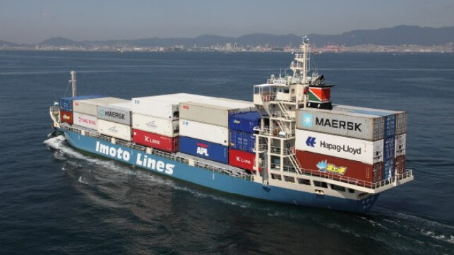
Imoto looks to leverages its expertise in feeders to develop a next generation hybrid containership (Imoto)

PUBLISHED APR 19, 2024 9:02 PM BY THE MARITIME EXECUTIVE


A Japanese consortium made up of coastal shipping company Imoto Lines and marine software company Marindows is launching a government-backed effort to develop a next-generation containership. Plans call not only for the vessel to address decarbonization with the ability to operate emissions-free, but also to address the emerging challenges due to the lack of seafarers in Japan. The companies have scheduled the completion of the vessel for January 2027.

Imoto, which is a leading operator of coastal feeder ships, reports the designs for the new vessel feature a hybrid operational capability centered on batteries. The vessel will be able to use containerized batteries that can be swapped out to extend its efficiency. They expect to power the vessel with three 20-foot battery containers with an assumed 2000kWh power capacity. It will employ a standardized and modularized universal plug-in hybrid powertrain.

The vessel will also be equipped to use shore power while on dock both to power its operations and to recharge. Using two 360kW engines, the vessel is expected to have a speed of 12.5 knots. Its maximum range in hybrid operations will be 2,700 miles while using just the three containerized batters it will have a range of 180 miles. It will also be designed for the future installation of low-environment impact technologies such as hydrogen fuel or the use of bio or synthetic fuel.

Plans call for the containership to have a capacity of 200 TEU. It is projected to be 499 gross tons with an overall length of 265 feet (81 meters) and a beam of 44 feet (13.5 meters). Miura Shipbuilding in Saiki City will build the vessel.


The hybrid containership will be designed for zero-emission operations and to address the growing shortage of seafarers 


The ship will be deployed on the route between Kobe and Hiroshima. It will also operate as a demonstration project supported by the Ministry of Environment’s Carbon Neutral Technology Research and Development Program.

In addition to addressing the challenges of zero-emission operations, Imoto points to the challenges of a shortage of seafarers and skilled mariners to operate vessels. The government has highlighted in the past the anticipated challenges as the Japanese population ages.

Working with Marindows they plan to develop standardized operations that will be supported by a shore operations center meaning the vessel will require fewer people and less skills and experience to operate. They report systems will be modularized and standardized for ease of operation.

One of the five goals of the project is to improve the work environment for crewmembers while also enhancing productivity per crewmember. They believe it will be possible to create a vessel that will have the same expenses as existing ships and can be environmentally friendly while costing basically the same as existing ships. 

They believe mass production will maximize the financial efficiency of the vessel for operators. Modularization will also permit them to protect from obsolesce by creating the ability to replace individual systems as new technologies are commercialized. 


Baltimore Opens Third Channel as Plans Sequence Efforts to Refloat Dali

Baltimore salvage
Progress continues in Baltimore with teams planning the efforts to refloat the Dali (US Army Corps photo April 19)

PUBLISHED APR 19, 2024 7:11 PM BY THE MARITIME EXECUTIVE


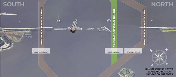
Recovery efforts in Baltimore continue to make good progress Maryland Governor Wes Moore highlighted in a briefing on Friday afternoon, April 19, reporting that more than 1,300 tons of steel have now been removed from the waterway. While the priority remains on establishing a lager temporary channel to reopen Baltimore harbor, late today they also opened a third temporary channel while the teams are also beginning to converge on the Dali for the effort to refloat and remove the vessel.

Crews they reported have now removed 120 containers from the bow of the vessel and expect to move approximately 20 more in the coming days to clear a path for the salvage team to safely reach the debris resting on the vessel. Governor Moore reported that each of the laden containers weighs between 1.5 and 2.5 tons and that in addition, the salvage teams project that there are 3,000 to 4,000 tons of steel from the bridge sitting on the bow of the vessel.

After the containers are removed, they are planning to build a staging area to address the debris. Representatives from the Army Corps of Engineers and the U.S. Coast Guard reported that they planning the effort to cut the sections of roadway and steel and remove it from the ship and then the refloating sequence. 


More than 100 containers have been removed over two weeks from the Dali (USCG photo)


Another 20 containers need to be removed before they begin staging for the controlled demolition of debris on the bow of the Dali (USCG photo)


They declined to specify a timeline for these efforts saying that the focus remains at this moment on establishing the Limited Access Channel. The third smaller channel established today should provide for about 15 percent of the harbor's normal traffic with a controlling depth of 20 feet, a 300-foot horizontal clearance, and a vertical clearance of 135 feet. Maersk earlier in the weekly however informed customers that the channels being established are too small for containerships and that they did not have a timetable for access to the port.

The Army Corp said they are working on debris wrapped around the other pier of the bride after teams modeling the channel identified this area as a priority. However, they noted that three salvage teams are also all working around the vessel as they plan the controlled demolition of the sections on and around the Dali. They noted that sections of the bridge’s pier are embedded in the vessel adding to the challenge to remove the ship. The plan is to take it back to a dock in Baltimore.


Three channels have been established which should permit approximately 15 percent of commercial activity in Baltimore (Unified Command)


Governor Moore highlighted that there are now 80 different assets working in the area and 380 people. They reported that 113 vessels have already passed through the first two channels and they are still on schedule to have the larger temporary channel established by the end of April.

Maryland also announced the next phase of financial assistance programs both for port workers and businesses impacted by the collapse of the Francis Scott Key Bridge. More than $5.5 million in assistance is budgeted and they will be paying people who worked at the port $430 a week as temporary job assistance.

At the same time today, Secretary of the Navy Carlos Del Toro traveled to Baltimore to personally assess the work. He met with both Naval Sea Systems Command and the Unified Command emphasizing the contribution of the Navy’s Supervisor of Salvage and Diving in the effort. The Navy is providing its diving expertise and coordinating efforts to aid in the recovery. The U.S. Army Corps of Engineers assigned the Navy’s SUPSALV with supporting by leading the clearing of the waterway.

During today’s briefing, they said two large sections of the bridge steel have already been successfully lifted. They are currently rigging a third section to be lifted.


“Forgotten city:” the identification of Dura-Europos’ neglected sister site in Syria


UNIVERSITY OF CHICAGO PRESS JOURNALS


The Dura-Europos site in modern-day Syria is famous for its exceptional state of preservation. Like Pompeii, this ancient city has yielded many great discoveries, and serves as a window into the world of the ancient Hellenistic, Parthian, and Roman periods. Yet despite the prominence of Dura-Europos in Near Eastern scholarship, there is another city, only some miles down the Euphrates river, that presents a long-neglected opportunity for study. A new paper in the Journal of Near Eastern Studies, entitled "The Ancient City of Giddan/Eddana (Anqa, Iraq), the 'Forgotten Twin' of Dura-Europos," identifies the city of Anqa as a near mirror image of Dura-Europos, of the same size, comparable composition, and potentially equal value to scholars of the region.

Anqa is located just across the Syrian border from Dura-Europos, in the present-day Al-Qaim district of the Anbar Governorate in Iraq. Its remains include an identifying tell mound, at the northern end of the site, a polygonal inner wall circuit, and a large outer defensive wall, or enceinte. Situated at a point where the Euphrates floodplain drastically narrows, the city would have controlled movement between the populous section of the valley upstream and the trade route downstream linking Syria, Northern Mesopotamia, and Babylonia, giving it great strategic and economic significance. However, the site was ignored entirely by archaeologists until the 1850 publication of a British Middle Euphrates expedition survey. A more thorough study of the site was performed in the late 1930s by Aurel Stein, including aerial photographs of the standing structures, but even after these forays, there was little desire to learn more than the geographical location of this twin city to Dura-Europos.

One reason for the disparity in interest between Anqa and Dura-Europos, posits article author Simon James, is the history of British and French colonial intervention in the region. In 1920, as a result of the San Remo conference, Iraq was seized for British control, and Syria for French. As James writes, the “new political, military, and administrative boundary created a barrier to research and understanding of the earlier history of the region as a whole.” Yet while Dura-Europos and some other sites in Iraq and Syria have suffered from looting, destruction, and civilian death as a consequence of conflict in the region, Anqa has remained relatively untouched. As further archaeological inquiry is performed, Anqa may continue to provide valuable insight into the history of the Middle Euphrates. And furthermore, as methods of digital scholarship bring thinkers together “despite political borders,” the practice of studying sites like it may even, in the words of Simon James, help “address the consequences of colonialism in archaeology.”

From Ancient Sumer to Kurdistan of Iraq

Updated: April 11, 2024
Author Sheri Laizer
Exclusive to Ekurd.net


Impressions made from Sumerian cylinder seal (and section of the seal itself far left) with: 4.2 x 2.5cm (seal). Photo: Courtesy of the Yale Babylonian Collection. Photography by Klaus Wagensonner (seal) and Graham S. Haber (impression). [1]Sheri Laizer | 


Ziggurats – The Meeting Place of Humanity with the Cosmos

To get behind the three major monotheistic religions and tap the mindset of the earliest civilizations of ancient Mesopotamia I felt that I had to be there –both mentally, and if possible, physically. In 1982, a year into my intense research into ancient Sumerian culture, Iraq was entering her second year of war against fundamentalist Iran. Hours spent using my reader’s card for the British Library, that was still then part of the British Museum gave me access to Sumerian art, literature, and the Sumerian cosmos but I wanted to go to Iraq.

The personnel of the Iraqi Embassy, and the Iraqi Cultural Centre were also most hospitable and encouraging of my ‘Ziggurats’ [2] book endeavour to revive what it was like to live there around 2300 BC. At the time, Saddam Hussein’s government was producing high quality publications in English like Ur Magazine.

When I began my research, let us remember that there was as yet no Internet, no Smart Phones, no instant online searches. Work was done through reading whatever published texts were available and examining artefacts. I typed my book, Ziggurats on a golf ball typewriter. Corrections were made with Tipex or white corrector ribbon on a spool. Communications for official purposes, like following up on the progress of visa applications went off by telex.


Ziggurats, a book by Sheri Laizer.

My requests made in this way to Baghdad in 1982 did not produce a reply despite the assistance of the Iraqi Cultural Centre or therefore the longed-for visa because of the war with Iran. I decided in view of that to carry out my physical placement in the Valley of the Kings in Egypt. It was an excellent choice. On the west bank of the Nile, I stayed in a very simple hotel for two Egyptian pounds a day. I read the books I had lugged there with me surrounded by palm trees and village culture and slowly wrote the book. It seemed obscure to people at the time and I set it aside, getting caught up in modern politics in the Middle East after moving north from Egypt to Israel and the Occupied Palestinian Territories to escape the increasing heat of southern Egypt. From there, I went on to Turkey and travelled in Turkish Kurdistan with Kurds I met there and later, in London. This led to my books on Kurdistan and a number of books and articles translated with Kurdish writers. Still, ‘Ziggurats’ laid on one side untouched in its original typed ms.

I had made three photocopies of the typed ms. of Ziggurats, held together by comb binding. One copy had gone to the Iraqi Cultural Attaché, another went to Peter Gabriel with whom I shared all my work, and the final was kept safe with the original ms. at home in Battersea, south London. Of all the things I have lost in the intervening decades, fortunately I did not lose that manuscript.

Ultimately, I obtained a tourist visa to Iraq a year after the ceasefire was signed between Iraq and Iran in October 1989 on a government sponsored tour aimed at showcasing reconstruction. An international group of journalists, we were taken to the ancient site of Babylon, the devastated south of Basra and Faw, to Kirkuk, Mosul, Erbil, Amadiya and Sulaymaniya as well as the historic sites of Baghdad like the inspiring split-onion dome Martyrs monument. My visa had been granted because of my Sumerian work – my Kurdish association naturally remained in the shadows.

In October 1989, therefore I at last inhaled the scents of Mesopotamia and felt that I had come home. I knew it so well from the work I had been doing. I had come to understand the Sumerian gods to represent the natural forces and astral bodies evoked by the Sumerian cosmologists, kings, artists and poets in an age when female deities were equal to men. Enheduanna, the high priestess of Ur was the first female author recorded back in the 23rd century BCE. [3]

In this way, the setting for my narrative, Ziggurats, paid homage to the ancient human mind – an enlightened culture that brought written language, law, art and science into human time. It was also that research that led me to political Kurdistan.

Human time and the study of the cosmos

In ancient Mesopotamia, along with the Sun, the Moon, the stars, and heavenly constellations, the five visible planets were recognised and studied by the priests and dignitaries of the temples and palaces. The texts intertwined astronomical, astrological, and religious aspects concerning the Moon and the planets into an overall organic astral body of knowledge. Astrology and celestial divination developed into firm lore. The Moon, the Sun, and the planets were interpreted as manifestations of divinities.

The Mesopotamians also developed a calendar from around 3000 BCE divided into years and months, evidence that they studied the Moon from the earliest times. The Sumerian and Akkadian names for the Moon god, Nanna/Sin, appear in cuneiform since approximately 2500 BCE. Akkadian names for the five planets, Mercury (Šiḫṭu), Venus (Dilbat), Mars (Ṣalbatānu), Jupiter (the White Star), and Saturn (Kayyāmānu), first appear in tablet texts from around 1800–1000 BCE when the phenomena of the Moon, the Sun, and the planets were interpreted as signs by the gods to communicate with human beings. Later Babylonian scholars between ca. 600-100 BCE reported lunar and planetary phenomena in astronomical records and ephemeris form in order facilitate predictions with time-based methods still in use by astrologers today. After the end of the 5th century BCE, Babylonian astronomers introduced the zodiac and developed new methods for predicting lunar and planetary phenomena known as mathematical astronomy. They developed horoscopy and other forms of astrology that use the zodiac, the Moon, the Sun, and the planets to predict events on Earth. [4]

They also discovered the 360-degree circle and devised the sixty-minute hour, additionally using a water measure of periods of double-hours…

Sumerian records of Erbil


The city of Erbil (Urbi-Lum) grew up on the flat Erbil plain and is mentioned in Sumerian sacred writings under the name of Urbi-Lum (Urbilum) or Arbilum, and Orbelum, followed by successive variants. The modern name أربيل Erbil is derived from Arba-Illu, with alterative renderings as Arbailu, Arabales, Arbira, Urbel, Arbail, Arbira, Arbela, Erbil/Arbil. The name Urbi-Lum was adduced by the Sumerian King Shulgi of the third dynasty (2000 BCE).

UNESCO has noted: “Written and iconographic historical records document the antiquity of settlement on the site…since pre-Sumerian times in several written sources. Archaeological finds and investigations suggest that the mound conceals the levels and remains of several layers of previous settlements, while the immediate and wider setting has revealed traces connected to the early development…It preserves over thirty metres of archaeological deposits going back to the very early beginnings of urbanisation in Mesopotamia. [6]

Erbil: Veneration of the goddess of love and war, Innana/ Ishtar

The Temple of Ishtar (Sumerian Inanna) that completed the top level of the sacred man-made hill that became the citadel in Erbil was typical of the sacred Sumerian sites within city centres. From around 3000 BCE, Urbi-Lum had come under Sumerian rule enduring until the rise of the Akkadian Empire (2335–2154 BC), in which the Sumerians and Akkadians, who spoke a Semitic language became one nation. [7]


Named as the Stele of Ishtar parading upon a lion from the Neo-Assyrian period 8th century BCE. (Louvre) from Tell Amar in the Erbil plain. Photo: Louvre.fr [8]Erbil was captured in 2150 BCE, by the Gutian King of Sumer, Erridu-Pizir. [9] King Shulgi subsequently sacked it during his 43rd year on the throne [10], and his Neo-Sumerian successor, Amar-Sin, sacked it anew and incorporated it into the greater Ur III state. [11]


By the 18th century BCE, Erbil features in a list of cities taken over in conquest by Shamshi-Adad of Upper Mesopotamia and Dadusha of Eshnunna [12] during their campaign against the land of Qabra. Now, Qabra is believed to be the site just south of today’s Erbil city called Kurd-Qaburstan, dating back to the Bronze Age a 118-hectare site with an 11-hectare central mound 17 metres high surrounded by an 84-hectare walled town lower down. The site is located at an important point midway between the Upper and Lower Zab rivers, and sits near a pass traversing the hills between Makhmur and Erbil, near to where, of current interest, the terror group, ISIS, has been regrouping since being expelled from Mosul late in 2017. The defeat and capture of Qabra by the two kings mentioned above are recorded on two stone steles, one retained by the Iraq Museum in Baghdad and the other still held in the Louvre. [13]


View from the lower town of Kurd-Qaburstan situated to the west of the mound. Photo: krieger.jhu.edu [14]

Shamshi-Adad installed garrisons in all the cities of greater Urbi-lum. During the 2nd millennium BCE, Erbil became incorporated into the Assyrian Kingdom from where its military forces embarked on their campaigns of conquest eastwards. [15]

A most intriguing letter on the dying Sumerian language and its use in ancient Erbil at the Qabra (Kurd-Qaburstan) site written to the King of Mari, Yasmah-Addu (1795-1776 BCE) has come down to us today:

“You wrote me to send you a man who deciphers the Sumerian in these terms: “Take for me a man who deciphers the Sumerian and speaks Amorite”. Who deciphers Sumerian and lives close to me? Well, should I send to you Šu-Ea who deciphers the Sumerian? […] Iškur-zi-kalama deciphers the Sumerian, but he holds a position in the administration. Should he leave and come to your house? Nanna-palil deciphers the Sumerian, but I must send him to Qabra). You wrote me this: “May someone send me a man from Rapiqum who can decipher the Sumerian!” There is no one here who reads Sumerian!” [16]

For centuries thereafter Sumerian was lost. Now, huge strides in deciphering the cuneiform texts in which Sumerian was written have been made and their content revealed to modernity.

Middle Assyrian Empire (1365 – 1077 BCE)

The Assyrians used the name arba’ū ilū (Arba-Illu), meaning ‘four gods’ according to Assyrian etymology and the oral tradition. Ishtar (Sumerian Inanna) remained one of the most important in the region under the Assyrians along with Assur, their patron god, whilst the identities of the remaining two gods are not now known. Under Assyrian King, Shalmaneser I (in power between 1273 – 1244 BCE) Erbil was an important provincial capital and a safe and secure part of the Middle Assyrian Empire.

King Shalmaneser I, boasted, “I built the Egašankalamma, the temple of Ishtar, the Lady of Arbil, my Lady, together with its ziggurat.“ [17]

The Kurdish name for Erbil is Hewlêr, which is believed to derive from the ancient Greek meaning “Temple of the Sun” from the Greek helio and may be associated with the Kurdish sun-worshipping religions, Mithraism, Zoroastrianism and of the Yazidi beliefs.

From the many sherds of pottery discovered on Erbil’s mound, or ancient tell, archaeologists believe Erbil was probably occupied since Neolithic times and certainly during the Copper Age (Chalcolithic or Eneolithic period), because fragments found there resemble the earthenware uncovered in the Jazira and in Anatolia from both the Ubaid and Uruk periods.

Erbil’s citadel site is believed to be the oldest continuously inhabited town in the world.

What is visible of Erbil city’s mound and citadel today is of much later date. The ziggurat and temple of Ishtar lie as dust beneath the Ottoman Turkish fortified settlement constructed in a sequence of alleys and cul-de-sacs that fan outwards from the Great Gate. A line forming a wall of tall 19th century house-fronts and habitations made of clay brickwork evoke the former grandeur of the fortress that dominated the city below. The elegant residential structures dating from the 18th – 20th centuries are being reconstructed and preserved by UNESCO with the co-operation of the Kurdish authorities. [18]

Dur Kurigalzu – the site northwest of Baghdad known today as Aqar Quf

(dedicated toEnlil- the Sumerian god of Enlightenment, storm and wind who decreed the fates)

The author, Sheri Laizer, gets to visit the ziggurat at Dur Kurigalzu in 2021 after many visits to the Erbil citadel. Photo: Sheri Laizer/via Ekurd.net

Dur Kurigalzu is a Kassite site and a significant part of its ziggurat remains visible. Dur is Akkadian, and means ‘fortress’, so it is the fortress of King Kurigalzu (now known as Aqar Quf). The ziggurat temple and surrounding city ruins lie some 30 kms northwest of Baghdad on the site of ancient Parsa dating back to the 14th-15th century BCE and the Kassite Kingdom of Kurigalzu I (1400 -1375 BCE) who from his seat there ruled over all Mesopotamia.

It is believed that the Kassites arrived in Mesopotamia from the Zagros mountains. They then rebuilt the cities of Nippur, Larsa, Susa and Sippar. The ziggurat at Aqar Quf was restored to its first level by President Saddam Hussein. Since regime change was imposed by the US-led invasion in the spring of 2003, Dur Kurigalzu has been neglected like the ancient Persian arch of Ctesiphon and the sprawling ruins Babylon that I also visited. Once highly frequented by locals and tourists, the sites are now the domain of stray dogs and bored military guards.

King Kurigalzu I’s impressive capital was later taken over by the Assyrian Kings. In the 1940s, Seton Lloyd and Taha Baqir led an Iraqi-British team at the site and discovered some hundred clay tablets as well as the fragments of a statue decorated with texts in Sumerian representing King Kurigalzu I. The dig also exposed the ruins of the 3,500-year-old ziggurat.

Dedicated to the Sumerian god, Enlil, the god of enlightenment, the ziggurat is among the best preserved of the Mesopotamian temple ziggurats, lying far to the north of the Sumerian city sites built between the Tigris and Euphrates rivers at the head of the sweet water marshes of Dhi Qar.

Enlil was the head of the Sumerian pantheon, a forerunner of the monotheistic God. His command was supreme and unalterable, and the destinies of men lay in his hands. He was the god of air, wind and earth, of the breath of life. From the Sumerian also came the story of the Flood and the creation myth of Man created from earth. Enlil divided the earth with a hoe, breaking the hard surface of the ground for seeds to grow. Men also came forth from the opening of the earth.

Worship of Enlil and of Inanna/Ishtar continued down through the Akkadians, Babylonians, Assyrians and Hurrians and he would also have been on the gods of Erbil, likely one of the two no longer known in addition to Ishtar and Assur. The Assyrians had also continued to worship the main four Sumerian gods, Enlil, An (Anu) Enki the god of water and wisdom and added their patron deity, Assur. Merchant traders would swear by the names of Ishtar, Ashur, and Nisaba that they were speaking the truth. [19]


Part of a Sumerian clay tablet depicting the god Enlil with his ring of power. Stele of king Ur-Namma, fragment showing the god Nanna seated on a throne, in front of the king (mainly lost). Found in 1927 in Ur. Penn Museum. 
Photo: Creative Commons/penn.museum/wikimedia

The lowest terrace of Enlil’s temple ziggurat was restored, and the structure’s mud-brick core rises above the surrounding plain with its palm trees and dusty scrub to a height of around 170 feet. It is flanked to the south by the ruins of three temples, several sanctuaries and the King’s former palace whose corridor walls had been decorated with numerous male figures, most likely thought to be dignitaries of the palace based on surviving works of sculpture. [20]

(Coming shortly: Part Two – The Ahwar and southern Mesopotamian temple ziggurats city sites with the most important at Ur, as below, courtesy of UNESCO) partly restored by Saddam Hussein.)

1 IMAGES: Courtesy of the Yale Babylonian Collection. Photography by Klaus Wagensonner (seal) and Graham S. Haber (impression).
2 Unir is the most common Sumerian word for ‘ziggurat’, and literally means “high-up (nir) amazingness (u(g))”. A literary term also exists for ‘ziggurat’, hursanggalam, which means “skillfully crafted (galam) mountain (hursang)”. Urbi-Lum (Erbil) had its own ziggurat and temple and is recorded in the Sumerian texts.
3 https://the-past.com/feature/prayer-and-poetry-enheduanna-and-the-women-of-mesopotamia/
4 https://oxfordre.com/planetaryscience/display/10.1093/acrefore/9780190647926.001.0001/acrefore-9780190647926-e-198#acrefore-9780190647926-e-198-div1-1
5 See archaeological study at 

7 The term ‘Semitic’ denotes a group of languages that include Arabic, Hebrew, Aramaic and the ancient languages of the Akkadians and Phoenicians termed as Afro-Asiatic languages. In contrast, Sumerian (Emegir meaning ‘native tongue’ and the literary form, Emesir) is a non-Semitic, lone or isolated language spoken since around 3000 BCE. Gordon Whittaker [30] postulates that the language of the proto-literary texts from the Late Uruk period (c. 3350–3100 BC) is really an early Indo-European language which he terms “Euphratic” (from the Euphrates river region) or Proto-Euphratean or Indo-European. See Gordon Whittaker at https://www.academia.edu/3592967/Euphratic_A_phonological_sketch from which the words, *ĝȹdȹōm dluk-ú- ‘the sweet earth’ → Ga2-tum3-dug3(u)44 ‘(mother goddess of Lagash)’… h2ner- ‘charismatic power’ → ner ~ nir ‘trust; authority; confidence’, parik-eh2- ‘courtesan, wanton woman’ > Eu. *karikah2- → kar(a)- ke3 / 4 ~ kar-a-ke4 ‘sexually free woman; (epithet of the goddess Inanna)’19 (metathesized from *karika) etc.
8 https://collections.louvre.fr/en/ark:/53355/cl010136226
9 Douglas Frayne, “Gutium” in “Sargonic and Gutian Periods (2234-2113 BC)”, RIM The Royal Inscriptions of Mesopotamia Volume 2, Toronto: University of Toronto Press, pp. 219-230, 1993 ISBN 0-8020-0593-4
10 Potts, D. T. (1999). The Archaeology of Elam. Cambridge University Press. p. 132. ISBN 9780521564960.
11 See a collection of papers on pre-Islamic Erbil at https://www.researchgate.net/
12 Eshnunna was also occupied through the Akkadian period and Ur III. Areas of the Northern Palace date to this period and show some of the earliest examples of widespread sewage disposal engineering including toilets in private homes. George, A. R. “On Babylonian Lavatories and Sewers.”, Iraq, vol. 77, 2015, pp. 75–106
13 Aruz et al. 2008; Beyond Babylon: Art, Trade and Diplomacy in the Second Millennium B.C. New York: 2008, Metropolitan Museum of Art cited in https://sites.krieger.jhu.edu/kurd-qaburstan/about-the-site/ and Ismail and Cavigneaux 2003
15 Villard, Pierre (2001), “Arbèles”, in Joannès, Francis (ed.), Dictionnaire de la civilisation mésopotamienne, Bouquins (in French), Paris: Robert Laffont, pp. 68–69, ISBN 978-2-221-09207-1
(English translation by Marie Young from D. Charpin).

17 Ishtar’s temple and ziggurat had pre-existed such that the King had rebuilt it or undertook a new construction there.

19 K.R.Veenhof and Dr.Edhem Eldem, 2008, p. 103
https://www.ancientpages.com/2019/05/03/ancient-ziggurat-of-aqar-quf-dedicated-to-god-enlil/

Sheri Laizer, a Middle East and North African expert specialist and well known commentator on the Kurdish issue. She is a senior contributing writer for Ekurd.net. More about Sheri Laizer see below.

The opinions are those of the writer and do not necessarily represent the views of Ekurd.net or its editors.

Copyright © 2024 Ekurd.net. All rights reserved