Sunday, June 28, 2026


Leaders Address Regulatory Barriers to Maritime Nuclear Technologies

U.S. Center for Maritime Innovation

Published Jun 27, 2026 12:08 PM by The Maritime Executive

[By American Bureau of Shipping]

The U.S. Center for Maritime Innovation (USCMI) convened industry, government and regulatory leaders for a workshop on Maritime Nuclear Technology Regulatory Barriers. Facilitated by its Secretariat, the American Bureau of Shipping (ABS), and in collaboration with the U.S. Coast Guard’s (USCG’s) Maritime Nuclear Policy Division and U.S. Maritime Administration (MARAD) leadership, the event focused on identifying and addressing the challenges associated with deploying advanced nuclear technology in the maritime sector.

The workshop brought together stakeholders from across the maritime, energy, and regulatory communities, including shipowners, shipbuilders, technology developers, classification societies and federal agencies. Participants explored pathways to enable the safe, secure and commercially viable adoption of nuclear-powered vessels and offshore energy platforms.

“The United States has a critical opportunity to lead in the deployment of next generation maritime systems powered by small modular reactors,” said Steve Carmel, U.S. Maritime Administrator. “Workshops like this ensure we are bringing the right stakeholders together to identify and address regulatory barriers, fostering innovation while maintaining the highest standards of safety and security.”

“The collaboration we are seeing across industry and government is essential to advancing maritime nuclear technologies from concept to reality,” said David Walker, Executive Director of the Secretariat operating the USCMI for MARAD and Vice President at ABS. “By convening stakeholders with diverse expertise, USCMI is helping to clarify regulatory pathways and accelerate progress toward viable, scalable solutions for the maritime sector.”

The workshop also featured keynote remarks and engagement from key federal partners, including Captain Robert Compher, Assistant Commandant for Prevention Policy at the USCG and Dr. Mehdi Reisi Fard Director of the Division of Advanced Reactor Engineering in the Office of Advanced Reactors at the U.S. Nuclear Regulatory Commission.

Through the workshop, a large audience of in-person and online participants shared their inputs on potential regulatory and other related barriers that oversight agencies need to address to facilitate safe deployment of this innovative technology in maritime applications. Discussions underscored the complexity of maritime nuclear deployment, including licensing pathways, safety frameworks, operational considerations and coordination across domestic and international regulatory bodies. Participants emphasized that continued collaboration between industry and government will be critical to enabling innovation while ensuring robust safety and security standards.
 

The products and services herein described in this press release are not endorsed by The Maritime Executive.


GPS Jamming Can Be Solved With Existing Satcom Signals

GPS is easily corrupted, but all sorts of other radio signals can be used for accurate positioning

GPS
Starlink's vast satellite constellation transmits signals that can be used for positioning, without any approval or involvement from the operator (SpaceX file image)

Published Jun 24, 2026 3:18 PM by The Conversation


[By Zak Kassas]

Few people want to get lost when traveling. But if there are places where being lost feels especially unsettling, they tend to be the sea, desert and sky. These environments share a defining feature: the absence of distinctive visual cues. Where horizons blur, landmarks disappear and every direction can look deceptively similar. Knowing where you are depends on information that you cannot see for yourself.

For most of human history, finding your way in such environments required skill, judgment and constant attention. Satellite navigation marked a fundamental shift. The advent of GPS has made navigation almost effortless: Press a button and voilĂ , location and heading appear instantly.

GPS’s great strength is that under benign conditions, it works remarkably well in precisely the environments where being lost would be most dangerous. Civilian systems routinely achieve meter?level accuracy. This accuracy, however, masks a growing vulnerability.

Over the past few years, deliberate GPS interference has surged worldwide, disrupting maritime and aviation operations at an unprecedented scale. I’m an electrical engineer who studies alternative methods of electronic navigation. My lab and others around the world are developing these alternatives as backup for when GPS is unavailable or unreliable.

When GPS is silent – or lies

Jamming overwhelms weak satellite signals with noise or radio frequency signals, blocking GPS position and time altogether.

Spoofing is more insidious: Counterfeit signals surreptitiously replace authentic ones, misleading GPS receivers about location and timing while appearing to crews and automated systems to operate normally.

Interference arises from three sources: military activity, criminal exploitation and accidental misuse. In conflict zones, GPS disruption has become a routine tool of warfare, used to protect assets, degrade surveillance and counter drones. This activity is well documented across Ukraine, the Black Sea, the Baltic Sea, the eastern Mediterranean and the Persian Gulf. It routinely spills over to affect civilian ships and aircraft, and civilian life.

Accidental GPS jamming has caused serious disruption at international airports by making it difficult for aircraft and air traffic controllers to track traffic in and out of the airports. Intentional GPS spoofing was even used in a highway heist to steal US$1 million worth of restaurateur Guy Fieri’s tequila.

Making matters worse, spoofed GPS data does not remain confined to a single system. Ships use the Automatic Identification System to broadcast their locations and to see what other ships are nearby to avoid collisions. The system broadcasts a ship’s GPS position information along with the ship’s name, course and speed, classification and call sign.

GPS spoofing effectively corrupts Automatic Identification System signals, sending false position information to nearby vessels, shore authorities, insurers and commercial tracking services. This activity can create fleets of “ghost ships” that appear real to others navigating nearby.

Criminals use GPS interference to block or alter Automatic Identification System information to evade oversight. Illegal fishing fleets, oil smugglers, sanctions evaders and maritime sand thieves have been repeatedly linked to falsified or disrupted Automatic Identification System and GPS signals.

Deadly consequences

GPS intereference is not new, and the U.S. government warned about it decades ago, but the scale of its impact has significantly accelerated over the past few years. GPS spoofing and jamming incidents affecting civil aviation increased by about 500% from January to August 2024.

Maritime authorities reported hundreds of ships affected daily, with groundings and collisions in 2024–25 publicly linked to interference of GPS and other satellite navigation systems, including in the Baltic Sea and the Strait of Hormuz.

The consequences have claimed lives. In December 2024, Azerbaijan Airlines Flight 8243 was struck by a Russian air-defense system, killing 38 people after the flight was diverted due to GPS interference. At sea, GPS interference in the Strait of Hormuz has caused oil tanker collisions.

GPS jamming caused the container ship MSC Antonia to run aground in the Red Sea near Jeddah, Saudi Arabia, on May 10, 2025.

Disruption has also forced runway closures, mass flight diversions and emergency procedures at Newark Liberty, Dallas-Fort Worth and Denver international airports.

Even senior officials are not immune: In 2025, GPS jamming forced an aircraft carrying the European Commission President Ursula von der Leyen to make an emergency landing.

Strait of Hormuz: Navigation danger zone

Recent incidents in the Strait of Hormuz during the U.S.-Iran war mark a decisive escalation in the risk posed by GPS interference. The strait sits at the intersection of intense geopolitical conflict and one of the world’s most critical maritime choke points. Around 20% of global petroleum trade transits these narrow waters each day, alongside dense commercial traffic. There’s little margin for navigational error. Here, even modest mistakes in position or timing can rapidly escalate into collisions, groundings or environmental disasters.

The Iran war has led to sustained spoofing across the Persian Gulf. Ships have reported positions via Automatic Identification System that place them on land or otherwise miles from their true locations without triggering alarms.

In the confined waters of the Strait of Hormuz, where ships pass one another in close proximity, GPS interference erodes situational awareness precisely where it matters most.

Crucially, interference in Hormuz is persistent rather than episodic. Reports show jamming and spoofing used systematically over extended periods, not merely as short-term responses to specific incidents. This pattern suggests that GPS disruption has become routine practice rather than a niche capability in electronic warfare.

Once normalized in one of the world’s busiest sea-lanes, such practices are difficult to contain geographically. The result is a navigation environment in which people can no longer fully trust position, timing and identity at sea. The consequences extend far beyond the confines of the Persian Gulf.

Beyond GPS

The normalization of GPS disruption exposes a deeper issue: Modern navigation resilience has been built around the assumption that GPS signals are usually available and trustworthy. As that assumption erodes, attention has shifted from hardening GPS toward security through diversification. This means drawing navigation information from fundamentally different signals.

For a backup to satellite navigation, several countries, including the U.K., France, Saudi Arabia, Russia, South Korea and China, are deploying or modernizing long-range radio navigation, or LORAN, a system that dates back to World War II.

Another alternative that has gained increased interest over the past decade or so is using signals never intended for navigation, referred to as signals of opportunity. In contrast to dedicated navigation systems, such as long-range radio navigation, this approach uses existing infrastructure and preserves scarce radio spectrum. A particularly fruitful type of signal to exploit is terrestrial cellular.

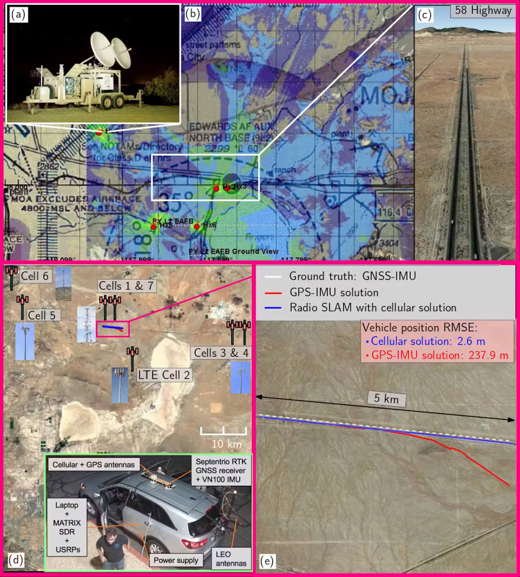
The author’s team tracked the path of its car using signals from cell towers during live GPS jamming at Edwards Air Force Base. Zak Kassas

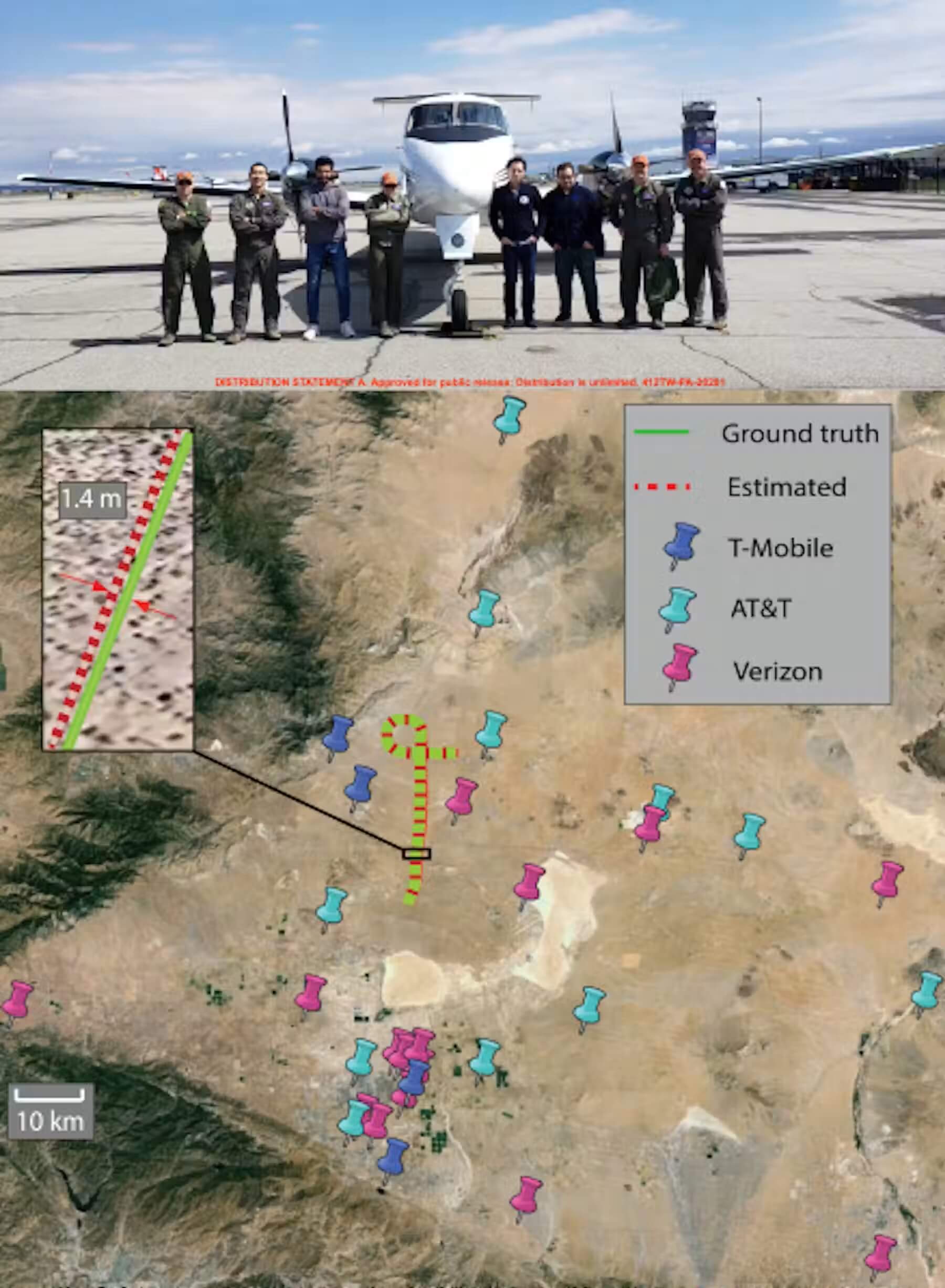
My lab has demonstrated this type of navigation with ground vehicles, unmanned aerial vehicles, or UAVs, high?altitude balloons and aircraft, including in GPS?jammed environments. We developed specialized receivers that exploit signals from existing LTE and 5G cellular networks.

We have demonstrated sub?meter accuracy on UAVs, near-lane?level accuracy on ground vehicles, and meter-level accuracy on aircraft and high-altitude balloons, without cooperation from cellular network providers.

The author’s team tracked the flight of a U.S. Air Force plane it was aboard using signals from cell towers, demonstrating that its method aligned closely with GPS. Zak Kassas

Another approach leverages the rapid proliferation of constellations of low Earth orbit communication satellites. Compared with GPS signals from medium Earth orbit, low Earth orbit satellites offer stronger signals, are numerous, transmit in a much wider swath of the spectrum, and their signals are more resilient to wide-area disruption.

We demonstrated meter-level positioning accuracy exploiting signals transmitted by Starlink satellites. We then developed receivers that can passively listen to signals emitted from multiple low Earth orbit satellite constellations.

The author’s lab demonstrated using satellite signals not meant for navigation to approximate the position-tracking ability of GPS. The blue line represents the vehicle’s GPS position and the green the vehicle’s position estimated by the researchers’ system.

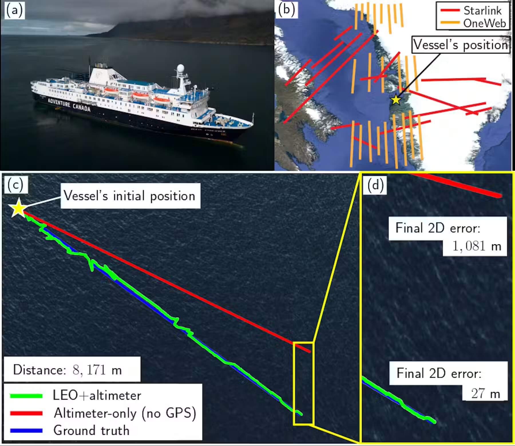
Since then, my lab has demonstrated navigation with low Earth orbit satellites across the U.S. In our latest experiment, we successfully navigated a vessel in the Arctic seas, off the coast of Greenland.

The author’s team tracked the course of a ship it was aboard in the Arctic using nonnavigation signals from low Earth orbit satellites. Zak Kassas

These results point to a pragmatic solution: Navigation resilience will come from a diversity of techniques. We and others are already demonstrating the technologies to do so. Whether they are put into practical use is now a matter of policy, regulation and timing.


Volkswagen Sells Majority Stake in Everllence to Bain Capital

Everllence

Published Jun 24, 2026 8:13 PM by The Maritime Executive


Automaker Volkswagen Group has agreed to sell a majority stake in its storied diesel engine division, Everllence - previously known as MAN Energy Solutions - to the American private equity giant Bain Capital. 

Everllence - formerly a division of MAN SE - can trace its roots back to the start of the Ruhr Valley iron smelting industry, but its engineering history is centered in Bavaria. MAN's Augsburg plant sponsored Rudolf Diesel's experiments in the late 1890s, fostering the invention of the diesel engine and the beginning of modern industrial power systems. MAN later became a leading maker of marine diesels through the acquisition of Burmeister & Wain in the 1980s, and was itself acquired by Volkswagen in 2011. The marine-diesel business was spun out of MAN SE as MAN Energy Solutions in 2018, placed under VW's direct ownership, then (last year) renamed Everllence. 

Today, it is a top manufacturer of large diesels for marine propulsion and power generation, and it also makes turbochargers and low-carbon power systems. Like others in the medium-speed segment, its fortunes have been boosted by the outsize power demands of data centers, which are growing so quickly and have such demanding requirements that they often require their own supplemental power generation. 

After six years of successful restructuring, Everllence has revenue of about $5 billion and a book value of $3.9 billion. Volkswagen Group has agreed to sell 51 percent of its stake in the company to Bain for about $8.4 billion in a leveraged buyout. VW says that it plans to retain the remaining 49 percent "in the medium term."

"Leaner structures and processes will give Everllence the opportunity to achieve further growth in attractive markets such as data centers, the energy sector and shipping. At the same time, it will allow us to focus even more strongly on our core business," said Oliver Blume, CEO of the Volkswagen Group.


US Coast Guard Charters an Offshore Vessel to Support its Cutters

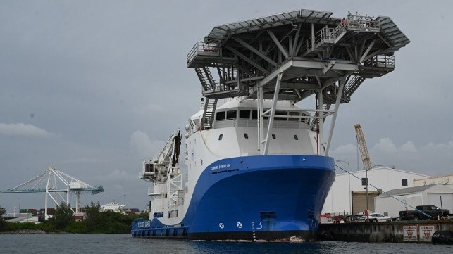
Connor Bordelon
Connor Bordelon (USCG)

Published Jun 26, 2026 3:37 PM by The Maritime Executive


The U.S. Coast Guard is taking a page from the U.S. Navy's operating manual and beginning to hire in civilian-crewed tonnage for sealift support, freeing up transit days for its cutters to remain at sea and stay on mission hunting drug-runners. 

The service's new Homeland Security Cutter-Ocean program is a newly-launched plan to bring in commercially operated vessels that can carry out the basic logistics on behalf of the cutter fleet, and specifically the Fast Response Cutters - small, capable vessels that can do the job of medium-sized cutters but are constrained in range and endurance by stores capacity. Having a "mother ship" that can deliver supplies and conduct crew change at sea - much like the function that a reefer ship performs for a high seas fishing fleet - will keep Coast Guard-manned law enforcement assets deployed in the mission area for longer. 

"As demands on the Coast Guard continue to grow, we must find innovative ways to sustain our fleet and keep our crews focused on the mission," said Vice Adm. Nate Moore, Deputy Commandant for Operations. "Homeland Security Cutter-Ocean will help us deliver critical supplies and personnel more efficiently while increasing the endurance and effectiveness of our operational forces."

The contract with Bordelon provides for the use of one offshore vessel, crewed by civilians and overseen by coastguardsmen. Bordelon's team will handle all the vessel operations, and the Coast Guard personnel will take care of the mission and the logistics - a pattern the service has previously experienced with the rapid delivery of the commercial icebreaker Aiviq, which came with a civilian crew in order to speed up the handover of a modern, technically complex vessel. 


Carnival Corp. Expands Surplus Meal Donations to the Dominican Republic

Carnival meal donations

Published Jun 27, 2026 12:25 PM by The Maritime Executive

[By Carnival Corporation]

Carnival Corporation (NYSE: CCL), the world's largest cruise company, today announced the expansion of its surplus meal donation program to the Dominican Republic, marking the second Latin American country to join the company's initiative to safely redirect prepared, unserved meals to local communities where its ships visit.

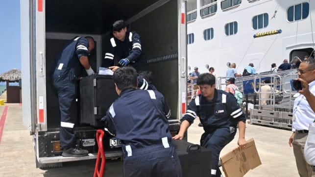
As part of Carnival Corporation's Less Left Over food waste reduction strategy, the donation of approximately 200 portions of prepared, unserved meals from Carnival Cruise Line's Mardi Gras was provided to the Archdiocese of Puerto Plata, Carnival Corporation's local program partner, for distribution to area organizations assisting families and the elderly. Supported by government collaboration, coordination with local partners ashore and Carnival Cruise Line's culinary teams, the effort is designed to move meals from ship to shore safely and consistently. The program is expected to expand quickly to all Carnival Cruise Line ships calling on Amber Cove.

With the addition of the Dominican Republic, the program has expanded to 19 ports since launching in 2017, helping address food insecurity in port communities where the company's ships visit. As of year-end 2025, the program has provided more than 320,000 meal portions to global communities since its inception, with plans to continue expanding the model into new markets.

"Bringing our surplus meal donation program to the Dominican Republic is an important part of expanding this work across Latin America," said Vicky Rey, vice president of government relations for Latin America, Carnival Corporation. "This work depends on clear processes, strong coordination with government and local partners, and a shared commitment to supporting the local community. Amber Cove's long-standing presence in Puerto Plata gives us a strong foundation to build on. We are grateful to the Archdiocese of Puerto Plata for serving as our local program partner, to our business partner Fabio Valenzuela, advisor to Rannik Group, and to government authorities for helping make this possible."

"We value Carnival Corporation's continued investment in Puerto Plata and its work with the Archdiocese of Puerto Plata to help ensure these meals reach organizations serving people in need," said Claritza Rochtte Peralta de Senior, governor of Puerto Plata. "This donation reflects the value of bringing the right partners together to support communities across the province."

The announcement builds on Carnival Corporation's long-standing role in Puerto Plata through Amber Cove, which opened in 2015 as an $85 million cruise destination that helped return cruise tourism to the region after more than three decades. Since then, Amber Cove has welcomed approximately seven million visitors, helped position Puerto Plata as a leading Caribbean cruise destination and created opportunities for local tour operators, artisans, vendors, transportation providers and small businesses.

The meal donation milestone adds to Carnival Corporation's broader work with local partners in Puerto Plata, including Maimón Basura Cero, a collaboration with the District Municipality of Maimón and Fundación Héroes del Medio Ambiente that is nearing completion of its third and final phase. The initiative is designed to strengthen local waste management by reducing solid waste sent from Maimón to the Puerto Plata landfill, encouraging separation at the source and supporting recycling and circular economy opportunities within the community.

As the leading cruise operator in the Dominican Republic, Carnival Corporation's eight global cruise lines will visit six Dominican ports in 2026, bringing more than 1.3 million guests and representing 50% of the country's cruise market share.
 

The products and services herein described in this press release are not endorsed by The Maritime Executive.

GREENWASHING

Port Canaveral Earns Green Marine Certification for 10th Consecutive Year

Port Canaveral Green Award
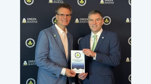
Port Canaveral’s Sr. Dir. – Environmental Bob Musser is shown accepting the Port’s Green Marine 10th year of certification from David Bolduc, Green Marine International's Pres. and CEO. (Credit: Canaveral Port Authority)

Published Jun 27, 2026 12:32 PM by The Maritime Executive

[By Canaveral Port Authority]

For the 10th consecutive year, Port Canaveral has earned Green Marine certification, continuing its decade of environmental leadership and sustainability performance among deepwater seaports. The achievement underscores the Port’s ongoing commitment to implementing responsible environmental practices across its diverse operations while continuously improving its environmental performance.

“Achieving this international certification year after year reflects our continuous commitment to operate responsibly and with respect for the natural resources that make our region such a special place,” stated Capt. John Murray, Port Canaveral CEO.

Bob Musser, Port Canaveral’s Senior Director, Environmental, added, "Environmental stewardship is fundamental to everything we do. Green Marine challenges participants to continually improve their environmental performance beyond regulatory requirements. Maintaining certification demonstrates our commitment to measure our performance, identify opportunities for improvement and, most importantly, implement sustainable practices that benefit both our operations and the surrounding environment.”

Green Marine is a voluntary international environmental certification program that includes ports, seaways, terminal operators, shipyards and vessel owners. Port Canaveral has been a member since 2016, earning certification that same year by meeting the organization’s rigorous environmental standards and performance criteria.

Participants are evaluated on a range of performance indicators that extend beyond regulatory compliance, including air emissions – including greenhouse gases and air pollutants – as well as aquatic ecosystems, community impacts, community relations, environmental leadership, spill prevention and stormwater management, underwater noise, and waste management. Certification requires annual self-assessments and every two years an independent third-party verification to ensure accountability and continuous improvement.

Since first earning Green Marine certification, Port Canaveral has maintained its standing in the program by demonstrating ongoing improvements and performance across multiple environmental categories while advancing initiatives that support long-term sustainability throughout its operations.
 

The products and services herein described in this press release are not endorsed by The Maritime Executive.


Underwater Ribbon Cutting Ushers in New URI Ocean Robotics Laboratory

Event marked milestone for Narragansett Bay Campus

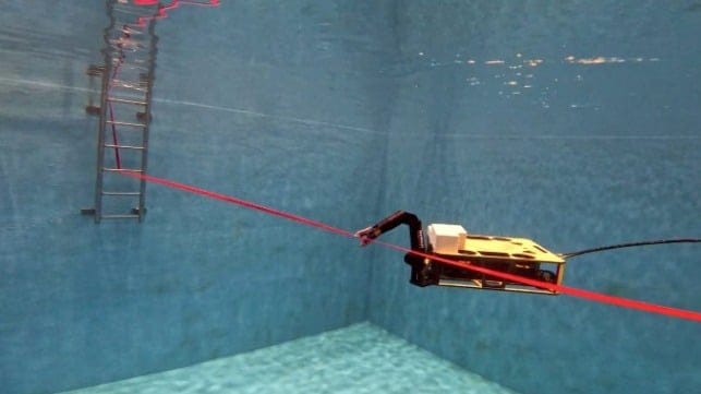
From within the ORL’s tank, ROV Rhody cuts the ribbon. (URI Photo: Inner Space Center)

Published Jun 27, 2026 2:02 PM by The Maritime Executive


[By The University of Rhode Island]

The University of Rhode Island celebrated a major milestone in the $300 million, multi-phase revitalization of the Narragansett Bay Campus with a ribbon cutting ceremony for the new Ocean Robotics Laboratory on June 25. 

Students Elliot Roman and Jake Bonney piloted URI’s remotely operated vehicle Rhody to cut the ceremonial ribbon underwater in the building’s 20-foot-wide by 30-foot-long test tank. 
Governor Dan McKee, House Speaker Emeritus K. Joseph Shekarchi, other local and state elected leaders, members of the URI Board of Trustees, and University faculty, staff, students, and alumni were among the hundreds who attended the ceremony.

“This is a major milestone in the revitalization of this campus,” said URI President Marc Parlange. “This campus is truly a hub for the blue economy in Rhode Island, with education, with research, with training, with extension, and partnerships with industry, as well as state and federal agencies. I am so grateful for the support of our state and federal elected officials and generous donors who make this transformation possible.”

Margo Cook, chair of URI’s Board of Trustees, also expressed appreciation on behalf of the University.

“Because of this investment made by our state leaders and the voters of Rhode Island, the new Ocean Robotics Laboratory is a cutting-edge resource to support our students, faculty, and our industry partners,” said Cook. “It's also a new recruitment tool for the state of Rhode Island that will attract and retain talent to advance the blue economy.”

Rhode Island voters supported the revitalization measures by approving two bond referenda totaling $145 million.

“URI has one the best oceanography programs in the entire country, and yet, we hadn't really invested a great deal in the infrastructure on the campus,” said Governor McKee. Noting a report from the state’s commerce board that estimated up to 60,000 jobs are available in the blue economy with proper investment, McKee continued, “What better place to invest than the University of Rhode Island.”

Shekarchi recalled visiting the Narragansett Bay Campus for the first time soon after he became speaker of the House of Representatives.

“I always held the oceanography school as a national treasure,” he said. “I came down here and I saw the antiquated facilities. It was a rainy day and President Parlange, ever the salesman that he is, took me through a few buildings and we had to use umbrellas inside the buildings because there were leaks coming down.”

The multi-year campus revitalization is changing that, with new, state-of-the art facilities that are advancing the design and development of technology-driven solutions.

“The people who will work in the Ocean Robotics Laboratory are building the robots and instruments that are needed to solve challenges by giving them shared space, innovative infrastructure, and place-based partnership opportunity,” said Steve D'Hondt, interim dean of URI’s Graduate School of Oceanography. “The facility will enable Rhode Island to take a commanding global lead in robotic ocean exploration and automated sensing of the ocean.”

Anthony Marchese, dean of the College of Engineering, said the research and innovation that will transpire in the new building is as relevant now as it has ever been.

“The taxpayers of the small but mighty state of Rhode Island were not only generous, but visionary because we are now poised to cut the ribbon on the ocean robotics laboratory at URI at a time when such a facility could not be more important for the region and for society at large,” Marchese said.

In speaking about the building and three words—research, development and deployment—that greet visitors upon their entry, Lora Van Uffelen, associate professor of ocean engineering explained, "We're all familiar with research and development. These are pillars of innovation everywhere. But what really makes us special and what makes this work unique is the deployment aspect. We as oceanographers and ocean engineers take instrumentation to sea, to the ocean. This is one of the most extreme environments we have on our planet, and it requires a lot of preparation. Facilities like this tank behind me are really essential for refining our systems before they head out to sea.”

Jason Noel, a Ph.D. candidate in ocean engineering, who earned a bachelor’s degree in ocean engineering with a minor in oceanography in 2022, expressed how much the new facility means to the students and faculty who will use it regularly.

“It truly is an amazing advancement for us and is exactly what this department was lacking,” said Noel. “We have always been at the forefront of research and talent, with amazing faculty, graduate students, and undergrads. The one thing that we were missing was the facilities to do our work.”

The graduate student also pointed out what the facility will mean for the blue economy and partnerships between URI and private industry.

“Not only is this building great for us, the researchers, but it is great for the state of Rhode Island,” said Noel. “We have the space here to support companies and integrate their work with existing research projects, as well as support larger organizations when they need facilities to test equipment. This creates a direct conduit between university minds and the state’s industry, keeping our talent local to our region.”

 
Several state elected officials spoke about the significance of URI’s new Ocean Robotics Laboratory.

Sen. Alana DiMario  

I could see the importance of investing in leveraging what we have here as such a great asset in the Ocean State, which is our proximity to the ocean and our ability to capitalize on research and different types of innovation and development to be able to utilize that to its full potential.

In our work in government, we often work on things that are slow and abstract and incremental, and we don't always get to see exactly how those things play out. Projects like this are such a thrilling exception. We get to see in standing here today what happens when we think big things, when we build big things, and then together when we do big things.

Rep. Carol Hagan McEntee

I would say that this is a great day for all of us. Investing in URI is one of the best uses of taxpayer dollars, and today's ribbon cutting on the new Ocean Robotics Laboratory demonstrates that. I'm excited to be part of this exciting development on the Bay Campus because this is an amazing transformation. 

Rep. Kathleen Fogarty

Investing in facilities like this new Ocean Robotics Lab provides tremendous advancements for the University and will attract the talent and research in ocean science and drive our economic growth. I look forward to seeing research and industry and collaboration at this new Ocean Robotics Lab for many years to come.     

Rep. Teresa Tanzi

Today's ribbon cutting demonstrates something very powerful here in Rhode Island—and that's the fact that state investments in facilities here at the University of Rhode Island have a massive impact. This represents the future of ocean exploration, research, education, technology development, and deployments—really another key part of the excitement around this project. We should be very proud of URI's achievements and the benefits these provide for our state.
 

The products and services herein described in this press release are not endorsed by The Maritime Executive.


Rising Tensions in Yemen Threaten Red Sea Transits

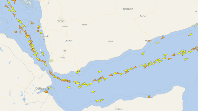
Heavy traffic on the Maritime Security Transit Corridor, June 25 (VesselFinder)

Published Jun 26, 2026 11:39 AM by The Maritime Executive

There have been a number of worrying indicators recently that tensions between the Houthis in the north and the Internationally Recognized Government (IRG) of Yemen, based in Aden, are rising.

To the great relief of the maritime community, traffic though the Red Sea, Bab el Mandeb and the Gulf of Aden was not disrupted in the bout of fighting which ended with the opening of talks between Iran and the United States in Switzerland. Paydari and IRGC hardliners in Iran attempted without success to persuade the Houthis to resume their attacks on shipping. Prior to the recent partial re-opening of the Strait of Hormuz, this would have had devastating impact; Saudi Arabia was shipping out its oil exports through the Red Sea, and much of the imports of basic essentials required by the Gulf countries were being trucked in after being landed at Jeddah. But apart from a few missiles and drones fired at Israel, which caused no damage and which were diplomatically ignored by Israel, the ceasefire came into effect without the threats made by AbdulMalik Al Houthi and the leader’s ebullient spokesman Brigadier Yahya Al Sare’e being realized. Naval vessels assembling for the Strait of Hormuz monitoring mission were able, in consequence, to pass through the Bab el Mandeb without disruption.

The general consensus is the Houthi leadership has not wanted to jeopardize progress being made in negotiations with Saudi Arabia, which promise to release substantial financial subsidies that would rescue northern Yemen from its current dire economic situation. A rash of economic protests have broken out in Houthi-controlled areas protesting against hunger and deprivation, emphasizing the need for urgent action to suppress what otherwise could become a threat to the Houthi’s grip on power.

Progress in these talks has evidently not been sufficient for the Houthis, who have now embarked upon an unpopular general mobilization to boost the size of their forces – and to pressure the Saudis with the threat of a resumption of hostilities.

At the same time, the Vice President of the IRG, General Tariq Saleh, has broadcast that he thinks a military clash with the Houthis is inevitable, preparations need to be made, and that compromise with the Houthis (who killed his uncle and tried hard to kill him) is impossible. Also a worry for the Houthis, the IRG has been consolidating its grip on the area it controls in Yemen, now that the UAE-backed Southern Transition Council has been defused as a separatist force. With some inevitable resistance, semi-autonomous militias have been brought under central administration, unifying command and control and improving military effectiveness, and all aided by reinvigorated support from the Saudis.

These developments have not threatened an immediate renewal of attacks on shipping in the Red Sea and Gulf of Aden. But on June 25, the risk of this happening increased. Both AbdulMalik Al Houthi, the Houthi leader, and a leading Houthi spokesman made speeches threatening imminent military action if Saudi Arabia did not concede more in ongoing talks, particularly with regard to what the Houthis say are unpaid salaries worth $13bn, in effect the salary roll of the Houthi rebel movement for the last decade. AbdulMalik Al Houthi also expressed his worries about what he identified as an Israeli presence in Somaliland, increasing the risk that the Houthis might attack targets there across the Gulf of Aden, over the heads of shipping using the Maritime Security Transit Corridor. These threats are evidently a response to growing criticism in Houthi areas of the domestic economic impact of their belligerent external policies.

With a very tenuous peace returning to the Gulf area, a resumption of disruption in the Gulf of Aden would create new challenges for the maritime industry - and commercial opportunities for specific sectors, notably container shipping. 


CMA CGM Containership Uses Iranian Route Through Strait of Hormuz

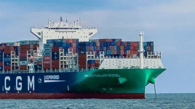
CMA CGM containership
CMA CGM's containership made the transit and is now anchored off Oman (CMA CGM file photo)

Published Jun 28, 2026 2:17 PM by The Maritime Executive


While the United Nations continues to say its evacuation plan for seafarers and their vessels remains suspended while it awaits further safety guarantees, ships are still making the transit. Container carrier giant CMA CGM confirmed in a brief statement that it has been able to move one of its trapped vessels through the Strait of Hormuz.

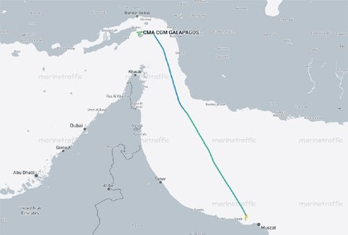
The 154,222 dwt CMA CGM Galapagos has now anchored off Muscat, Oman, after having been trapped in the Persian Gulf since the start of the conflict at the end of February. No details were provided on the transit of the vessel, but tracking shows it proceeded to the Iranian-sanctioned route near Lark Island. 

Built in 2022, it is an ultra-large container vessel registered in France with a capacity of 15,254 TEU. Other carriers, such as Hapag-Lloyd, Maersk, and Evergreen, have also highlighted that they were able to move vessels out of the Gulf, but most of them have been smaller feeder-type vessels.


CMA CGM took the northern corridor for its transit (courtesy of Marine Traffic)


CMA CGM called the safe transit of its vessel “an important milestone in a regional context,” but did not provide additional details. The online routing shows the vessel is resuming a trip to China, where it is shown to be arriving in mid-July. CMA CGM said it has 10 additional vessels that remain in the Persian Gulf, but did not comment on any plans to possibly evacuate other ships.

It comes after IMO Secretary-General Arsenio Domingues said on Friday that they had been able to evacuate at least 115 vessels in three-and-a-half days before suspending their efforts. He said that represented about 2,500 seafarers out of an estimated 11,000 seafarers aboard around 600 ships still trapped in the Gulf.

The IMO said it had paused the operation after the IRGC made statements that vessels in the region that used an unauthorized corridor would be subject to “legal sanctions.” Dominguez said they were following up on that statement when they learned the Ever Lovely had been struck, and that prompted the pause. He also repeated the statement that the Ever Lovely had not been in touch with the Omani officials and was not following the IMO’s procedures, although Evergreen Line says it was transiting on the route recommended by UK Maritime Trade operations.

However, while he said the official position was that the evacuation effort was suspended, Dominguez said they had preliminary information Friday that a further 11 vessels were making the transit in the northern corridor maintained by Iran, and four were in the southern corridor off Oman.

Iran continues to assert that the only route is its corridor and that all vessels require its permission regardless of the agreements. It stuck the Evergreen Line Ever Lovely on Thursday and the tanker Kiku on Saturday, saying that both vessels were not following the procedures. Donald Trump said Iran had launched four drones on Thursday, with the U.S. having shot down three. 


U.S. Central Command reported later on Saturday that it had struck a further 10 Iranian military targets in response to “continued Iranian aggression against commercial shipping.” Reports said Iran had responded by launching retaliatory strikes against U.S. bases in Kuwait and Bahrain. 

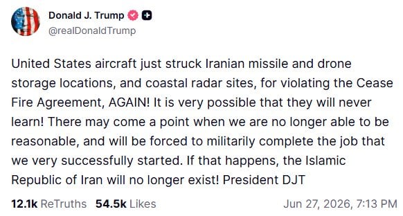
Trump took to social media to repeat his threats against Iran. He said the U.S. “struck Iranian missile and drone storage locations, and coastal radar sites, for violating the Cease Fire Agreement, AGAIN! It is very possible that they will never learn!”

Despite the recent back-and-forth strikes, ships appear to be making the transit. Maritime AI data intelligence firm Windward calculated that 18 vessels had been outbound from the Gulf on Saturday, June 27, with one operating dark. It reported that 22 vessels were inbound, although it did not detail which corridor was being used. Citing data from Vortexa, it said 3.9 million barrels of crude and a total of 4.12 million barrels had transited outbound.


Tanker Struck by Drone off Oman and the US Again Responds with New Strkes

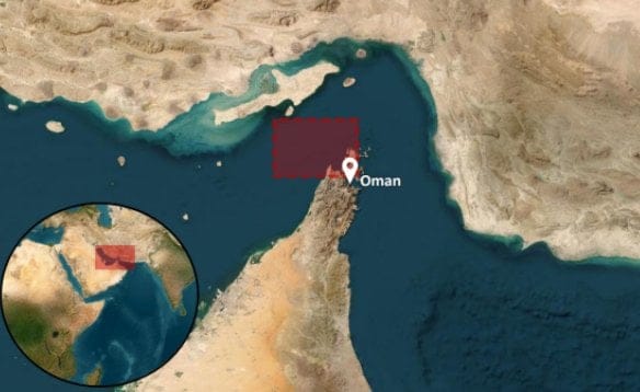
location tanker was struck in the Persian Gulf
Tanker was struck by an Iranian drone on Saturday off Oman for not transiting in Iran's route (UKMTO)

Published Jun 27, 2026 4:07 PM by The Maritime Executive

A laden Panama-flagged tanker outbound from the Gulf was struck early on Saturday, June 27, as Iran continues to say it is firing “warning shots” at any vessel attempting to make the transit without its permission. Donald Trump called the attack on Thursday on the containership Ever Lovely a “foolish violation of our ceasefire agreement” while the U.S. has now staged two rounds of retaliatory strikes on Iranian infrastructure. As a result of the potential escalation, the Joint Maritime Information Center (JMIC) raised the threat level to “substantial” just days after it had been lowered to “moderate.”

The Greek-owned tanker Kiku (300,866 dwt) registered in Panama, was hit early on Saturday, June 27. It had loaded at the Al Shaheen Offshore Terminal in Qatar and was bound for Singapore more than two-million barrels of crude oil, says U.S. Central Command. The tanker was reported to have been approximately 22 nautical miles off Ras Al Khaimah in the UAE when it was struck. The master told UK Maritime Trade Operations (UKMTO) that the crew was safe, but the vessel had sustained damage.

MSCIO (Maritime Security Center Indian Ocean) reports the tanker was struck by a drone on its starboard bridge wing. It says the damage was minor and that the tanker was continuing its passage. However, the vessel’s AIS shows that it was bound for Fujairah in the UAE.

The attack on the tanker was followed by several drones launched toward Bahrain. The Bahrain Foreign Ministry reported “a number of drones,” with Iran contending it was targeting U.S. military installations with “defensive strikes” after the “barbaric” air strikes by the U.S. overnight on Friday. Earlier, Iranian officials had repeated their assertion that “the Strait of Hormuz is governed by Iran, so respect the rules.”

Donald Trump, in a social media posting, said Iran had fired at least four one-way attack drones at ships transversing the Strait of Hormuz. He said the U.S. “knocked down” three drones, but one had struck the Ever Lovely

Both sides are accusing the other of violating the ceasefire agreement. CENTCOM said in a statement, however, "Iran was given a chance to honor the ceasefire agreement but elected not to when its forces launched a one-way attack drone that hit M/T Kiku."

Late on Saturday, CENTCOM forces launched strikes in response to continued Iranian aggression against commercial shipping. U.S. military aircraft targeted Iranian military surveillance infrastructure, communication systems, air defense sites, drone storage facilities, and minelayer capabilities. CENTCOM asserts that commercial vessel transits through the Strait of Hormuz continue. It ays U.S. forces remain vigilant, lethal, and ready.

Earlier today, JMIC had advised that the southern route has been expanded to accommodate simultaneous inbound and outbound traffic. Concerns had been raised when the southern route near the coast of Oman was opened, that it was narrow and raised the risk for incidents. The International Maritime Organization repeated the earlier assessment that there are at least 80 mines in the Traffic Separation Scheme lanes of the Strait of Hormuz.

The IMO, however, continued to pause its evacuation effort, saying it was waiting for more information and renewed safety guarantees. It asserted the containership Ever Lovely was not under the IMO’s evacuation framework. Evergreen Line, however, said in a statement that it was transiting the Strait of Hormuz in accordance with the recommended route issued by the United Kingdom Maritime Trade Operations (UKMTO).

It said the damage to the containership was limited to the “eaves” of the bridge and two of the bridge windows. The containership remained fully operational and seaworthy, said Evergreen, and it was continuing its trip. Two other Evergreen containerships, identified as Ever Unicorn (5,652 TEU) and Ever Lotus (8,500 TEU), completed their transit through the Strait of Hormuz safely without any abnormal incidents, Evergreen said. It reports that all vessels operated by Evergreen Line have safely departed the Persian Gulf.


U.S. Conducts Counterstrike on Iran in Retaliation for Ever Lovely Attack

F/A-18
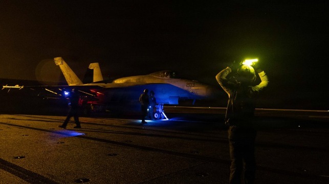
Night operations aboard USS George H.W. Bush, June 20 (USN)

Published Jun 26, 2026 7:49 PM by The Maritime Executive

In response to yesterday's Iranian attack on a Taiwanese boxship in the Strait of Hormuz, U.S. forces have conducted an airstrike on Iranian territory. Sources differ on the scope of the attack, but - like the White House before it - Iran's IRGC is treating it as a violation of the recent ceasefire MOU. 

According to U.S. Central Command, U.S. aircraft hit Iranian missile and drone storage areas and coastal radars in retaliation for the attack on the boxship Ever Lovely. "The unwarranted aggression against commercial shipping by Iranian forces clearly violated the ceasefire," CENTCOM said in a statement. 

The Iranian government news network IRIB reports that "two projectiles have struck a telecommunications tower in the Sirik area," but did not confirm the damages claimed by CENTCOM. Independent social media accounts have issued reports of explosions in the Sirik region, without specifics. 

Iran's IRGC said in a brief statement that it considers the ceasefire MOU to be "officially violated." It claimed various breaches of four clauses in the MOU, including the deal's provisions for a ceasefire on all fronts of the clash. 

Behind the rhetoric and the limited exchange of fire, it appears that the U.S. and Iran have begun to use an open hotline to communicate directly and control escalation, according to Amwaj Media. The newly-created hotline mechanism is limited to civilian diplomatic exchanges so far, not military-to-military contact, and is only conducted by phone - not in person. It appears that its first use was to manage the cycle of retaliation that began with the strike on Ever Lovely, Amwaj reports - an indication of coordinated demonstrations of military strength, calibrated for messaging.

Later in the day, Iranian sources claimed to have conducted retaliatory strikes on U.S. Army positions in the region. According to the Iran-affiliated account Hormuz Letter, the IRGC has threatened that if commercial ships again use the central Omani transit lane - not the IRGC-administered northern lane - then "our response will be broader than this."

Internal unrest 

Iranian and Kurdish sources have reported a skirmish in the border region of Baneh, near majority-Kurdish areas of Iraq. The militant group YRK reported an attack by Iranian drones near Baneh, resulting in damage to several farms but no casualties among Kurdish fighters. 

On Friday, the Kurdistan Free Life Party (PJAK) reportedly conducted a counterattack on an IRGC checkpoint between Baneh and Saqqez. The IRGC-affiliated Sepah News reports that two Iranian guards were killed and five wounded in an ambush. 

President Donald Trump has previously claimed to have dispatched arms to Kurdish fighters in the region in order to support a possible uprising against the Iranian regime. The PJAK - considered a terrorist group by Turkey and Iran because of its advocacy for Kurdish territorial independence - has denied receiving American support. 


Full Steam Ahead In the Strait of Hormuz? Not So Fast

The situation around the Strait of Hormuz remains uncertain

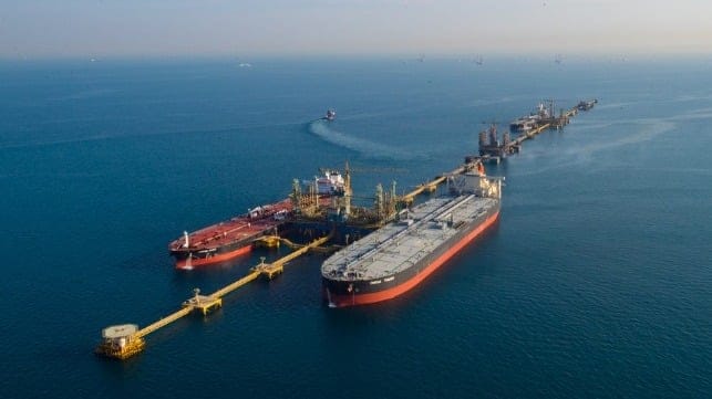
Ras Tanura

Published Jun 26, 2026 8:49 PM by Erik Broekhuizen / Poten & Partner


On June 17, the US and Iran signed a 14-point memorandum of understanding (the “Islamabad Memorandum” or MoU). This set up a 60-day extension of the ceasefire, specifically intended for drafting a permanent treaty. The agreement committed both nations to an immediate and permanent cessation of military operations on all fronts. Another step was the immediate toll-free reopening of the Strait of Hormuz and the lifting of the U.S. naval blockade. A little more than a week after the agreement was signed, we can take stock of what has transpired so far as expected and which developments have surprised the oil and tanker markets.

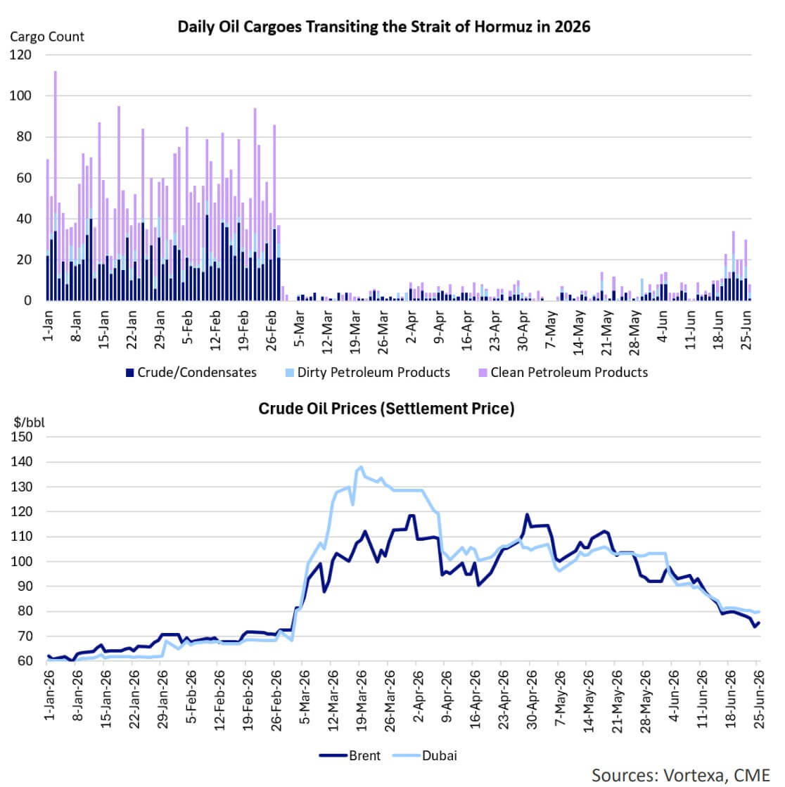
Some of the early changes in the oil and tanker markets were fully expected. First of all, oil prices fell. That was not a surprise. The Memorandum promised a ceasefire and reopening of the Strait of Hormuz, the key chokepoint for Persian Gulf exports. Brent fell below $79 on June 18 after the interim deal was signed, and today it is trading around $72 per barrel, approximately the same price as on February 27, the day before the Iran war started. While nobody was shocked that oil prices came down, the speed with which crude gave up the war premium did surprise the market. The expectation had been that recovery would take weeks or months. Instead, oil prices are back at prewar levels just nine days after the 60-day Hormuz deal was signed, disrupting expectations of a much slower market recovery.

The reason for the rapid oil price retreat is that oil traders look towards the future. Once traders saw actual tanker movements, an OFAC license lifting sanctions on Iranian oil sales, and Gulf producers preparing July loadings, the market looked through the remaining uncertainty and started discounting future supply. As expected, Iranian oil sales quickly picked up after the US lifted its blockade. On June 22, the US Treasury Department issued Iran General License X, authorizing the production, sale, delivery, and offloading of Iranian-origin crude, petrochemicals, and petroleum products through August 21, 2026. The license also covered practical shipping services such as vessel management, crewing, bunkering, piloting, insurance, classification, salvage, and even U.S.-dollar payments. That mattered because the MoU created a temporary legal corridor for trade.

In addition to Iran, other Persian Gulf producers also started to resume loadings. For example, Saudi Arabia resumed crude loadings at Ras Tanura’s Ju’aymah offshore terminal after nearly four months. The UAE, Qatar and Kuwait are also ramping up exports. Iraq, which was badly impacted by the closure of the Strait of Hormuz (its production plummeted from 3.3 Mb/d to 1.3 Mb/d), is boosting production from the Basra fields in the South of the country to maximum capacity. However, while the fields are coming back, actual export volumes from Iraq's southern Gulf terminals are lagging slightly behind those of Saudi Arabia and the UAE.

How did the tanker market respond to the “reopening” of the Strait of Hormuz? Initially, tanker rates jumped. Everybody suddenly needed ships, but many owners were still holding back, ships were out of position, vessels were queued or trapped, and every voyage carried legal, security, insurance, and route uncertainty. At the same time, even with a deal, hundreds of vessels trapped inside the Gulf could not all leave at once, companies and insurers would wait for safety clarity, mine clearance and navigation-lane issues to be resolved. According to the IMO, an estimated 80 sea mines need to be recovered before the traffic separation scheme in the center of the Strait of Hormuz can be reopened.

Despite these uncertainties, traffic through the Strait of Hormuz initially jumped significantly after MoU was signed. However, the IRGC attack on a container ship on Thursday increased doubts again about the safety and security of vessels and crew. Following the attack, the IMO suspended its evacuation plan, intended to help free the vessels and seafarers still stuck in the Persian Gulf. The ongoing uncertainly has kept tanker rates particularly volatile. After an initial spike, rates dropped as owners realized there was a abundance of tonnage and that the Iranians were still trying to control traffic through the Strait of Hormuz. This begs the question: Will the situation ever get back to "normal"?

This market update appears courtesy of Poten & Partners. 

The opinions expressed herein are the author's and not necessarily those of The Maritime Executive.

 

IRGC Navy Rejects Oman's Safe-Passage Plan for Strait of Hormuz

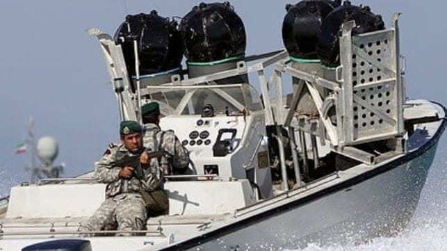
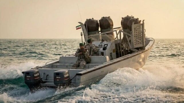
IRGC Navy personnel on a minelaying boat (IRGC file image)

Published Jun 24, 2026 10:41 PM by The Maritime Executive

In a brief message released Wednesday night, Iran's Islamic Revolutionary Guard Corps Navy said that it rejects the newly-announced Omani safe transit route through the southern half of the Strait of Hormuz. The route is one of two options offered by the IMO's safe transit plan for Hormuz exits. 

"The proposed route is unacceptable and poses serious safety risks," the IRGC Navy said in a brief statement. In the context of recent Iranian attacks on shipping, the "safety" warning carries the weight of a credible threat. 

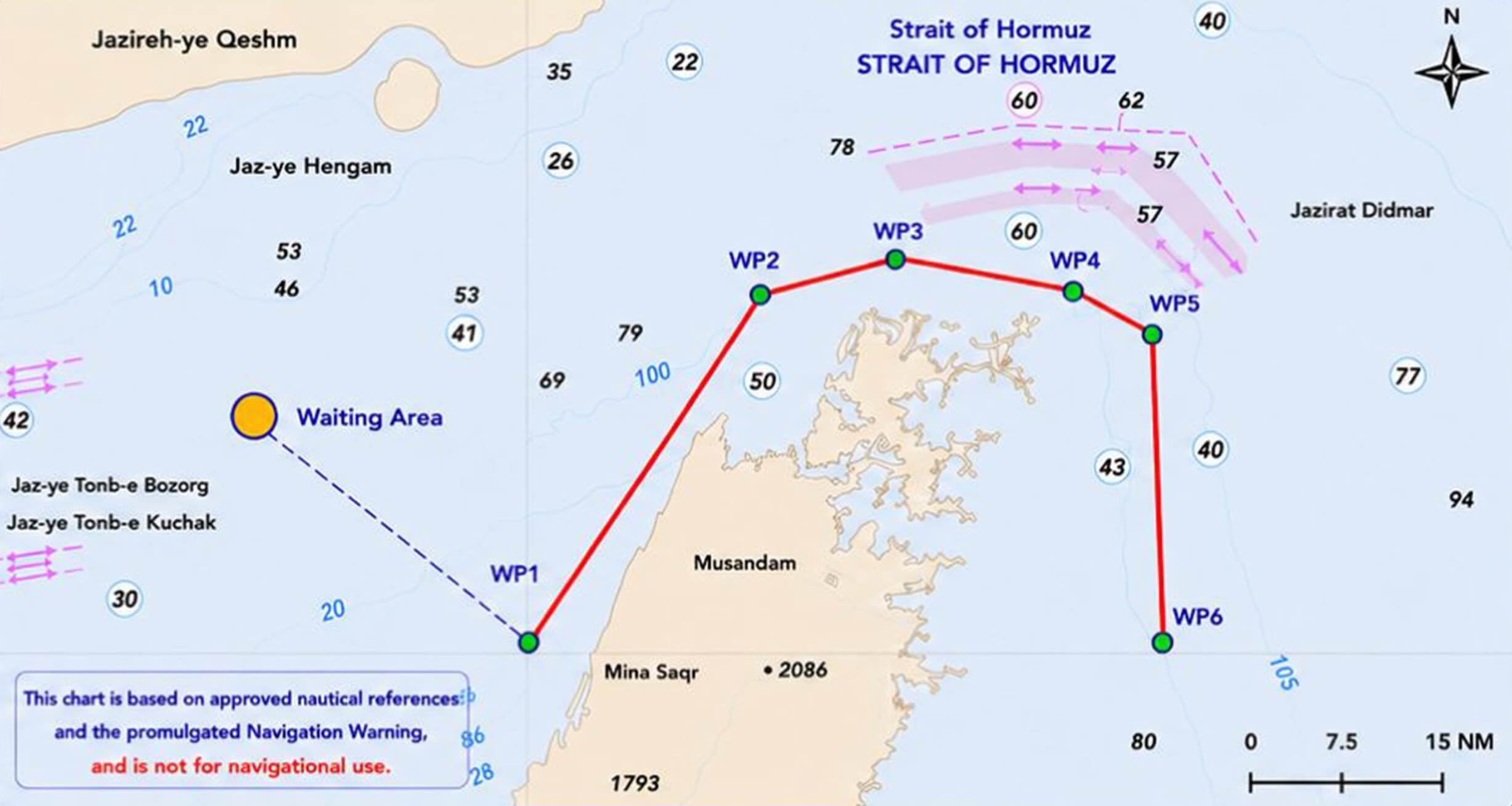
The IMO/Omani route to the south of the TSS, near the Musandam Peninsula (Sultanate of Oman)

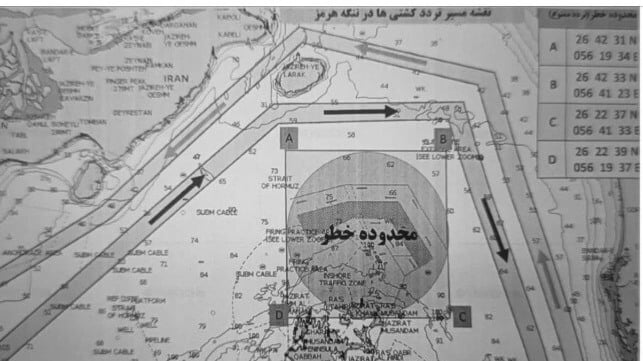
The IRGC Navy route to the north of the TSS, near Qeshm (IRIB)

The IRGC Navy is in charge of administering on-the-ground operations of Iran's preferred route through the Strait of Hormuz, which runs on the north side of the waterway past Qeshm Island (above). Iran previously sought to charge fees for the use of this route, and - before the recent U.S.-Iran ceasefire MOU - it routinely attacked ships that attempted to bypass its "authority" by using the southern stretch of the strait. It still has long-term plans to administer traffic in the strait, in conjunction with Omani authorities, with the intention of implementing a fee structure for as-yet-unspecified maritime services. 

The IRGC Navy's new threat comes amidst a significant uptick in shipping volume through the strait. On Tuesday, about 30 ships made the passage, including the first few transits on the new IMO/Omani route. The Omani passage consists of a designated waiting area inside the Gulf and six waypoints around the Musandam Peninsula, keeping ships just south of the original Traffic Separation Scheme, which is believed to be mined. 

The route is contained within Omani waters and jointly coordinated between the Sultanate of Oman and the IMO. From start to finish, it is a short 4-5 hour voyage - but a nerve-wracking one for seafarers, given the 11 mariner deaths that have occurred to date in the conflict. 


Hormuz and the Era of Assymetry: Sea Mines and Unmanned Systems

An IRGCN fast patrol boat with naval mines. (Courtesy of Tasnim News Agency)

Published Jun 26, 2026 2:34 PM by CIMSEC

[By Admiral Massimo Vianello (Ret.) and Master Chief Petty Officer Giovanni Giorguli (Ret.)]

The conflict between Iran and the Israel-United States alliance confirms that conventional armed forces must currently confront asymmetric threats that subvert the logic of traditional power projection. In the maritime domain, naval mines, sabotage, and unmanned systems (UAVs, USVs, and UUVs) offer a highly favorable cost-benefit ratio for the weaker actor: low-cost attritable swarms can saturate adversary defenses, effectively neutralizing the overall technological gap.

These threats, once categorized as one-off tactics employed in isolation, are now weighted by indigenous industrial capacities and employed at scale by Iran and its proxy networks. They are systematically integrated with cyber operations and strategic disinformation campaigns designed to destabilize financial markets, energy security, and global communication architectures.

In the Middle Eastern theater, Iran exercises strategic control over the Strait of Hormuz through the employment of Unmanned Aerial Vehicles (UAVs), sea mines, coastal defense cruise missiles (CDCMs), and Fast Inshore Attack Craft (FIAC), deliberately avoiding a conventional naval engagement that would result in its defeat. The global economic fallout – reduced energy availability, supply chain disruption, and the escalation of insurance premiums and fuel costs – generates political instability and constrains international relations. When such a posture is sustained by great powers, it can be maintained over the long term, as demonstrated in the Ukrainian theater where Western-funded mines, drones, and missiles have effectively contained the Russian navy’s operational freedom.

The shifting paradigm of maritime engagement in the Middle Eastern theater, specifically within the Strait of Hormuz, underscores a transition from traditional naval confrontation to a sophisticated asymmetric and multi-domain posture. This analysis examines the Iranian threat profile, characterized by the integration of Anti-Access/Area Denial (A2/AD) strategies, and highlights the critical role of naval mining and the proliferation of unmanned systems. Furthermore, this article explores the emergence of seabed warfare as a critical operational domain, highlighting the vulnerability of Critical Undersea Infrastructure (CUI) and the necessity for persistent Seabed-to-Space Situational Awareness (S3A). By evaluating the integration of Emerging Disruptive Technologies (EDTs) and artificial intelligence driven autonomous systems, this paper argues for a balanced, gradual evolution toward autonomous systems, while addressing the operational, legal, and ethical challenges posed by the robotization of the maritime battlespace.

The Profile of the Iranian Threat

Following the 1979 Islamic Revolution, Iran adopted a posture of radical ideological and strategic hostility toward Israel, severing all diplomatic ties. Refusing to recognize the Jewish state, Tehran has employed rhetoric calling for its destruction and has long conducted a proxy war against Israel through a network of militarily and financially supported affiliates (Hezbollah, Hamas, and the Houthis). Tehran pursues a nuclear program, which Israel perceives as an existential threat. Furthermore, Iran views the United States as a threat to its sovereign survival. Consequently, Iran has consistently prioritized the development of A2/AD capabilities. This strategy encompasses not only the nuclear sector but also strategic missile deterrence and non-conventional capabilities, including the subsurface domain.

Specifically, drawing from the operational lessons of the Tanker War and Operation Desert Storm, the Islamic Revolutionary Guard Corps Navy (IRGCN) assigns a pivotal role to naval mines for the strategic control of the Strait of Hormuz and the Persian Gulf. Sophisticated mining techniques result from exercises focused on pre-planned measures to blockade or interdict maritime traffic using indigenous and Russian-derived moored and bottom mines, as well as Chinese-manufactured self-propelled mines. While Iran’s primary maritime area of interest is the Strait of Hormuz, its regional interests are projected elsewhere via support for terrorist factions, such as the Houthi operations in the Red Sea.

Iran has developed a subsurface component based on small, heavily armed platforms capable of executing asymmetric and saturation tactics, which can be suitable for seabed warfare operations.

The underwater order of battle (ORBAT) includes three 1990s-era Kilo I class submarines, one Fateh class coastal submarine, and between 14 and 17 midget submarines (one Nahang class and approximately 16 North Korean/indigenous Ghadir class). These are augmented by locally produced Swimmer Delivery Vehicles (SDVs) of the Al-Sabehat and Ghavasi types for Special Operations Forces (SOF) tasks. Recently, the inventory has expanded to include the Nazir-1 Extra Large Unmanned Underwater Vehicle (XLUUV) and weaponized UUVs (small-scale, long-range slow torpedoes).

While the opacity of the maritime environment provides opportunities for covert subsurface operations – ranging from SOF insertion to mine-laying via surface units and midget craft – the overall underwater component also appears to maintain credible anti-ship capabilities (ASuW).

Countering Asymmetric Threats

The IRGCN and the Islamic Republic of Iran Navy (IRIN, or NEDAJA) function as two distinct naval entities, operating across different geographical Areas of Interest (AOIs) and employing divergent tactical doctrines. The former, an integral branch of the Revolutionary Guard, holds primary responsibility for asymmetric defense within the Persian Gulf and the Strait of Hormuz. The latter is focused on the protection of long-range maritime interests, blue-water patrolling, and counter-piracy operations.

Given that the IRIN’s surface combatant capability was effectively neutralized following engagements with U.S. forces, Iran’s national defense now rests fundamentally upon coastal missile batteries and the IRGCN. Consequently, it is characterized by a pronounced asymmetric posture that currently maintains a degree of containment against American military superiority.

Naval Mines

Although it is estimated that only a limited number of devices have been deployed in Hormuz to date, Iran possesses a substantial inventory of underwater ordnance (ranging between 2,000 and 6,000 units), consisting of indigenous designs and Russian or Chinese-derived systems. Therefore, the mine threat in the Strait of Hormuz must be assessed as substantial. Furthermore, it cannot be ruled out that Iran might resort to protective mining of its territorial waters, utilizing influence mines such as the MAHAM 7 (a mine that strikingly similar to the Italian Manta) and MAHAM 5, as well as contact mines like the Sadaf 01 – specifically in the approaches to Kharg Island and Bandar Abbas – to deter amphibious landings.

Additionally, the IRGCN’s asymmetric doctrine suggests the potential for Special Forces/combat diver attacks against naval units in port or at anchor, utilizing MAHAM 4-type timed limpet mines.

Under these operational conditions, Counter-Mine (CM) strategies must be conducted through preliminary left-of-launch strikes against storage depots and minelaying platforms – a tactic employed by both the USN and the Russian Federation in the Ukrainian conflict – followed by MCM (Mine Countermeasures) operations against deployed ordnance. In this latter phase, while Unmanned Underwater Vehicles (UUVs) provide significant utility for Search, Detection, and Classification (SDC), international subject matter experts maintain that effective Mine Warfare (MW) still requires specialized platforms capable of operating in high-risk contested environments where minefield boundaries remain ill-defined. This requirement is underscored by the fact that, despite the loss of primary minelaying vessels to U.S. strikes, Iran retains the capacity to seed or refresh minefields using small, fast-attack craft or Craft of Opportunity (COOP) operated by the Pasdaran.

It is therefore critical that MCM vessels are either deployable alongside the main fleet or pre-positioned in contested chokepoints. Given the persistent asymmetric threat, traditional clearance operations should ideally be reserved for the post-conflict phase to reopen commercial Sea Lines of Communication (SLOCs). During active hostilities, UUVs should be utilized for contingency interventions or risk reduction within temporary break-in channels to facilitate power projection ashore, should conditions permit.

The Houthi movement also possesses a significant naval mine arsenal. However, due to bathymetric constraints, these are primarily deployable along the Yemeni littoral to counter Saudi Coalition forces, rather than for the strategic interdiction of the Bab El Mandeb – a task for which they employ other asymmetric vectors in synergy with Iran. 

In a broader sense, the deployment of naval mines generates a psychological impact that analysts have cogently summarized: “The mined area does not have to be everywhere, to be everywhere in the minds of those who must transit it…” implying that even a negligible number of mines can precipitate complex, high-intensity crisis scenarios.

Unmanned Systems: The Proliferation of Multi-Domain Robotic Warfare

The proliferation of unmanned systems has cross-sectionally impacted all warfare domains – land, air, and sea. The operational effectiveness demonstrated by Ukrainian maritime drone strikes against Russian Federation naval units, both in ports of origin and on the high seas, serves as a definitive case study of the evolving nature of naval engagement.

In the underwater dimension, despite persistent challenges related to acoustic propagation for communications, unmanned platforms are driving significant shifts in tactical procedures and are increasingly integrated with traditional naval assets.

Beyond the extensive use of Unmanned Aerial Vehicles (UAVs) for ISR (Intelligence, Surveillance, and Reconnaissance) and risk-mitigation for personnel, these platforms are now being effectively deployed as offensive vectors. This is further evidenced by the emergence of Unmanned Combat Underwater Vehicles (UCUVs), reportedly integrated into the inventories of the Al-Qassam brigades and Houthi militants.

To counter aerial threats, Counter-Unmanned Aircraft Systems (C-UAS) have rapidly evolved ranging from soft kill solutions (electronic jamming, spoofing, and hijacking) to hard kill capabilities. These range from interceptor drones equipped with net-capture to High Energy Laser (HEL) systems, kinetic effectors, and High Power Microwave (HPM) systems. The latter utilize high-intensity electromagnetic pulses to irreparably damage a platform’s electronic circuitry, resulting in immediate loss of control and neutralization.

Furthermore, the implementation of Remote ID regulations in the civil sector provides a framework that may enhance military tracking and identification Friend-or-Foe (IFF) protocols.

Regarding underwater threats, electronic countermeasures such as the Mobile Jammer Target Emulator (MJTE) are under development to counter UCUV attacks, while several nations have initiated regulatory frameworks for the governance and management of underwater battlespace.

A critical requirement remains the enhancement of capabilities to counter swarms of low-cost unmanned vehicles operating in a coordinated manner, which can saturate or severely degrade traditional defensive layers. In this context, HPM systems – which require only electrical power and offer continuous duty cycles without cooling – induced downtime – appear to be the most viable long-term solution for swarm interdiction, where conventional kinetic or laser engagement is often too slow or cost-prohibitive.

Moreover, Chinese research suggests that even fiber-optic guided drones – which have proven resilient to traditional Electronic Warfare (EW) in the Ukrainian theater – would likely succumb to high-power microwave pulses.

Attacks on Critical Undersea Infrastructure (CUI)

Strategic submarine fiber-optic cables traverse both the Strait of Hormuz and the Bab El Mandeb, where they are highly vulnerable to proxy-led interdiction – either via the accidental dragging of anchors by seemingly innocuous vessels or through deliberate underwater sabotage, similar to the Nord Stream gas pipeline kinetic strikes in the Baltic Sea.

This evolving threat landscape is driving the emergence of a new operational doctrine known as Seabed Warfare, central to this doctrine is the persistent maintenance of Seabed-to-Space Situational Awareness (S3A). This framework is designed to detect anomalous behavior, triggering subsequent inspection and exploration of the seabed where Critical Undersea Infrastructure (CUI) is located, primarily through the deployment of UUVs to mitigate threats or assess damage.

This new warfare paradigm requires the seamless integration of all assets operating within the underwater battlespace, traditionally involving Anti-Submarine Warfare (ASW), MW, and diving operations.

However, deploying unmanned systems in the subsurface dimension entails greater technical challenges than surface operations, primarily due to acoustic propagation constraints which limit communication bandwidth and range. This has spurred intensive Research and Development (R&D) efforts, often in synergy with civilian research centers, to enhance the mission endurance and operational autonomy of underwater drones across vast CUI networks.

Consequently, it is crucial to consolidate capabilities in automated underwater docking stations (for power recharging and mission data transfer), underwater mesh networks (Internet of Underwater Things – IoUT), and Machine Learning (ML) algorithms. By providing unmanned platforms with increased autonomous decision-making capacity, these technologies compensate for the inherent sub-surface communication latency.

Simultaneously, seafloor sensor arrays and the dual-use of fiber-optic cables via Distributed Acoustic Sensing (DAS) technology are becoming essential for the detection and tracking of sub-surface threat vectors.

In summary, while there is an urgent requirement to counter threats that interdict commercial transit through maritime chokepoints and disrupt hydrocarbon flows, there is an equally pressing need to protect both the sub-sea cables – which serve as the backbone of global economic interconnectivity –and the physical sub-surface infrastructure for energy transfer, such as gas and oil pipelines.

Conclusion

As noted by prominent geopolitical analysts Dario Fabbri, the geostrategic postulate remains more valid than ever:

“He who commands the sea possesses a distinct advantage, both offensively and defensively. He commands communication lines that require neither creation nor maintenance, can evade inland-originated aggression, establish the primary defensive perimeter within the depths, deprive adversaries of logistics, and lead the international system by regulating the flow of global commerce.”7

Contemporary maritime dominance mandates that great powers exercise effective thalassocracy: controlling strategic chokepoints, ensuring Freedom of Navigation (FONOPs), and maintaining indispensability to allied networks. For the United States, restoring secure transit through the Strait of Hormuz is not merely an energy security concern, but a strategic imperative to maintain hegemony over global markets before the rapidly expanding People’s Liberation Army Navy (PLAN) occupies the resulting power vacuums. While great powers pursue these objectives through complex and diversified carrier strike groups and fleet architectures, regional actors such as Iran pursue them via asymmetric warfare. This demonstrates that the technological gap can be mitigated through the integrated employment of naval mines, unmanned systems, coastal defense missiles, and FIAC (Fast Inshore Attack Craft) swarms.

In this landscape, the persistent availability of ISR-T (Intelligence, Surveillance, Reconnaissance, and Targeting) capabilities – encapsulated in the S3A framework – and the rigorous monitoring of pattern of life” constitute the essential prerequisites for modern maritime operations. The Hormuz theater has specifically underscored the necessity for robust MCM capabilities capable of executing the full MCM kill chain – detect, classify, identify, and neutralize – integrated with sub-surface surveillance arrays and fiber-optic technologies such as Distributed Acoustic Sensing (DAS). The multi-layered threat environment – comprising mines, missiles, UAVs/USVs, and fast-attack craft – demands a sophisticated multi-threat response capability and increasingly seamless interoperability with the civilian infrastructures managing sub-sea communications.

The prevailing trend toward casualty cross-reduction is accelerating the deployment of robotic and autonomous systems (RAS). The operational success already demonstrated by surface and underwater drones across multiple conflict theaters provides an unequivocal signal regarding the future trajectory of naval combat. However, overly ambitious transitions from conventional to fully autonomous architectures may prove counterproductive: unmanned systems possess tangible vulnerabilities – such as entanglement nets, floating cables, and physical hostile seizure – and face significant operational constraints in harsh sea state conditions. Consequently, a phased approach to remote integration is required, validated through realistic operational exercises such as those conducted by NATO, which embed military subject matter experts alongside industrial technicians in high-fidelity field conditions.

The consolidation of emerging and disruptive technologies – artificial intelligence, big data analytics, and quantum computing – will finalize this transformation, enabling levels of automation capable of autonomously managing system responses and asset coordination. This process necessitates a parallel evolution of international law – ranging from UNCLOS to international humanitarian law – to define the legal status of unmanned platforms and address the inevitable ethical dilemmas posed by lethal autonomous weapons systems capable of kinetic engagement without direct human intervention.

Massimo Vianello is a retired Italian Navy Admiral who graduated from the Italian Naval Academy. Specializing in underwater weaponry and Mine Countermeasures (MCM), he has commanded coastal minehunters, a frigate, and the sailing vessel Amerigo Vespucci. His extensive operational experience spans critical theaters, from the First Persian Gulf War and Operation Allied Force to Operation Mare Nostrum. As a former Commander of both the Mine Countermeasures Forces and the 29th Naval Task Group, Admiral Vianello now leverages his expertise as an Analyst for the Center for Geopolitical and Strategic Maritime Studies (CESMAR), where he serves as a leading subject matter expert on sub-surface warfare and undersea security.

Giovanni Giorguli is a retired Italian Navy Master Chief Petty Officer and an Autonomous Underwater Vehicles (AUVs) pioneer with almost 40 years of expertise in Mine Countermeasures and underwater technology. He is a veteran of international operations such as those in the Persian Gulf, Operation Allied Force, various NATO missions, and the 2022 FIFA World Cup security framework in Qatar. Throughout his career, he served as a key instructor and searider, shaping Italy’s national underwater tactics and doctrine. A Knight of the Order of Merit of the Italian Republic, he has authored and contributed to publications on Seabed Warfare and subsea infrastructure protection. He is currently an analyst at the Center for Geopolitical and Strategic Maritime Studies (CESMAR).

The opinions expressed are those of the authors and do not reflect the views or policy of any organization with which they are affiliated. No organizational endorsement is implied or intended.

This article appears courtesy of CIMSEC and may be found in its original form here

The opinions expressed herein are the author's and not necessarily those of The Maritime Executive.