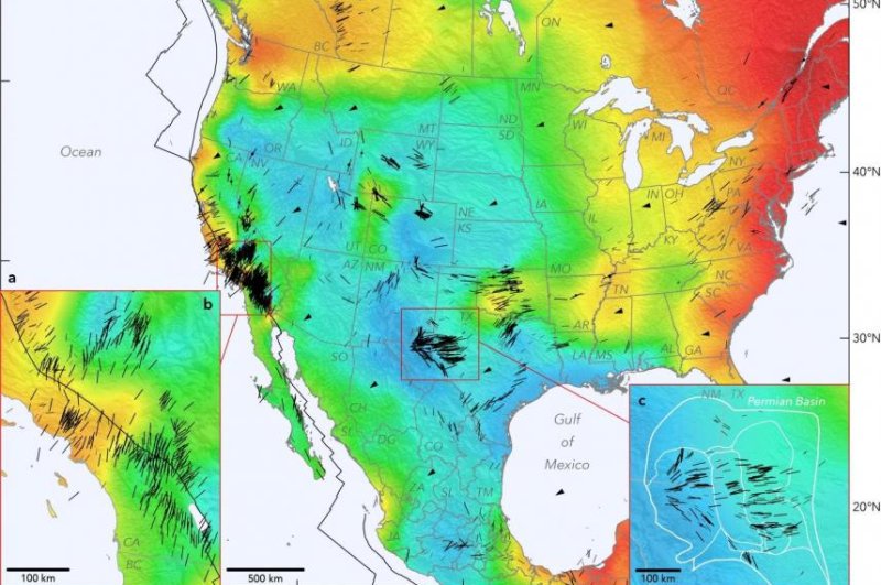
Map of tectonic stresses in North America could help assess tremor risk

A new map of North America shows the different types and directions of stress that influence the continent's crust. Photo by Jens-Erik/Lund Snee/Mark Zoback
April 23 (UPI) -- For the first time, scientists have produced a comprehensive map of the tectonic stresses acting on the North American continent.
In the short term, the map of North American faults -- published Thursday in the journal Nature Communications -- could help scientists assess the risk of major tremors, as well as take steps to mitigate human-caused earthquakes.
In the long term, the map could inspire and inform modeling efforts aimed at better understanding North America's geologic past, as well as the continent's present day tectonic intricacies.
"Understanding the forces in the Earth's crust is fundamental science," study co-author Mark Zoback, professor of geophysics at Stanford University, said in a news release. "In some cases, it has immediate application, in others, it may be applied decades later to practical questions that do not exist today."
RELATED Timing of Earth's biggest earthquakes follows a 'devil's staircase' pattern
To build the map, researchers compiled localized data on fault features using measurements from boreholes drilled across the continent. Scientists used historic seismic data to estimate the types of faults found in different parts of North America.
The three most common types of faults are extensional, strike-slip or thrust. On extensional faults, crust extends horizontally. Landmasses slip past each other along strike-slip faults. On thrust faults, landmasses move over and under the other.
Most earthquake hazard maps contain little to no information on the types of tectonic mechanisms that might fuel the next big one. The new map could help risk models better account for the kinds of earthquakes likely to strike across varying parts of the continent.
RELATED Study of shear zones yields data on earthquakes deep below surface
In addition to aiding risk assessment, the new map and the data that informed its compilation could help scientists better understand the behavior of North America's subsurface.
"If you know an orientation of any fault and the state of stress nearby, you know how likely it is to fail and whether you should be concerned about it in both naturally-triggered and industry-triggered earthquake scenarios," said lead study author Jens-Erik Lund Snee, a former Stanford doctoral student and now a postdoctoral fellow with the United States Geological Survey. "We've detailed a few places where previously published geodynamic models agree very well with the new data, and others where the models don't agree well at all."
Across the Eastern United States, scientists expected rebound forces to dominate the region's crustal stress. It was only 20,000 years ago that the weight of massive glaciers receded from atop the region. But the new mapping effort showed the region's crustal stress is mostly caused by the stored energy of tectonic shifts.
RELATED Geologists figure out what fuels 'slowquakes'
On the other side of the continent, scientists were surprised to find a diversity of stress types and shifts in stress directions over short distances -- the kinds of localized changes that are missed by current geologic models.
"It's just much clearer now how stress can systematically vary on the scale of a sedimentary basin in some areas," Zoback said. "We see things we've never seen before that require geologic explanation. This will teach us new things about how the Earth works."
No comments:
Post a Comment