Post-wildfire landslides becoming more frequent in southern California
American Geophysical Union
U.S. Geological Survey
Joint Release
WASHINGTON--Southern California can now expect to see post-wildfire landslides occurring almost every year, with major events expected roughly every ten years, a new study finds. The results show Californians are now facing a double whammy of increased wildfire and landslide risk caused by climate change-induced shifts in the state's wet and dry seasons, according to researchers who mapped landslide vulnerability in the southern half of the state.
"This is our attempt to get people thinking about where these hazards are going to be before there's even a fire," said Jason Kean, a hydrologist at the U.S. Geological Survey in Denver and lead author of the new study in Earth's Future, AGU's journal for interdisciplinary research on the past, present and future of our planet and its inhabitants. "By proactively thinking about hazards, you can start to develop more detailed response plans for their inevitability."

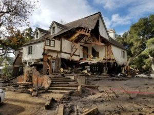
Damage from a major post-wildfire landslide that occurred on 9 January 2018 near Montecito, Santa Barbara County as a result of the 2017 Thomas Fire.
Credit: USGS/Jason Kean.
Wildfires make the landscape more susceptible to landslides when rainstorms pass through, as the water liquefies unstable, dry soil and burned vegetation. Geologists routinely conduct landslide hazard assessments after wildfires occur, but there is often not enough time between a fire and a rainstorm to implement an effective emergency response plan, Kean said.
In the new study, Kean and his colleague combined historical fire, rainfall and landslide data with computer simulations to forecast where post-wildfire landslides are likely to occur in southern California, how big those landslides might be and how often they can be expected to happen. Their goal was to map which regions of the state are most vulnerable to landslides before they happen, in a manner similar to how geologists map earthquake hazards.
Their results show small landslides can now be expected to occur almost every year in southern California. Major landslides capable of damaging 40 or more structures can be expected every 10 to 13 years - about as frequently as magnitude 6.7 earthquakes occur in California, according to the study. The results also suggest more intense rainfall, which is likely to happen in the coming decades, could make landslides much more frequent.
Combined with recent research showing California's wildfire season is getting longer and the rainy season is getting shorter and more intense, the new findings suggest Californians face a higher risk of wildfires and post-wildfire landslides that can damage property and endanger people's lives.
"We're going to have a longer season to burn and then when it does rain, it's going to come down harder. And that's a bad recipe for these post-fire debris flows," Kean said. "The reason you can expect one just about every year is because it doesn't take very much rain to cause one. The rainstorms that can trigger debris flows - they're kind of garden-variety storms."
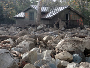
Damage from a major post-wildfire landslide that occurred on 9 January 2018
California's central coast has already seen a significant landslide this year. A portion of Highway 1 near Big Sur was washed out in a landslide in late January after a severe rainstorm. Kean hopes the new study's results can help emergency managers plan out evacuation zones for landslides before they happen.
"We'll still always do hazard assessments after fires because we really want to know the details of the actual fire, but these wildfires scenarios and storm scenarios are useful because we can start looking ahead and have the luxury of time to make a better plan," he said.
###
AGU (http://www.
Notes for Journalists
This research study is open access. Download a PDF copy of the paper here. Neither the paper nor this press release is under embargo.
Paper title:
"Forecasting the frequency and magnitude of postfire debris flows across southern California"
Authors:
Jason W. Kean, Dennis M. Staley: U.S. Geological Survey, Denver, Colorado, United States.
This press release and accompanying images are available online at: https:/

No comments:
Post a Comment