September heat kept alive a warming trend seen over much of the summer in the North Atlantic. Scientists say its more evidence of climate change.
Key Points
A burst of heat over parts of the North Atlantic and Arctic oceans continued a series of summer record-breakers.
The warmer water temperature helped fuel creation of a hurricane much farther north than typical.
Hotter than normal temperatures weren’t just confined to the American Southwest as September started.
A burst of heat over parts of the North Atlantic and Arctic oceans continued a series of summer record-breakers that brought unusually warm temperatures to the world's coolest regions.
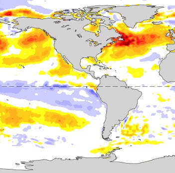
A huge melt event occurred on Greenland’s ice sheet last weekend, when temperatures rose above freezing, even at an elevation near 10,000 feet. At the same time, warmer water temperatures – as much as 9 degrees above normal in parts of the northern Atlantic Ocean – helped fuel creation of a hurricane much farther north than typical.
Three-month seasonal summaries released last week reported temperature and melt records in Greenland, Svalbard and the Swiss Alps. To scientists in the region, the melting glaciers and warmer waters seem to be further evidence of the changing climate, although further research will be done to attribute specific events.
This summer “shifted the realities for Alpine glaciers,” said Matthias Huss, a glaciology professor at ETH Zürich and Glacier Monitoring Switzerland. He finds the speed of melt in the Alps “hard to accept.”
A glacier in northern Greenland taken during a NASA science flight on July 11, 2022.
USA TODA
“Within just two months, a mountain pass at Les Diablerets in western Switzerland, ice-covered for several thousand years, became ice-free,” said Huss. All previous records were shattered at one location monitored by the university’s glaciology group for more than 60 years.
“We measured 4 meters of melt at the highest observation site,” the group posted this week. “Simply shocking, and sad. This is a glacier on its way to extinction.”
And if you find the numbers difficult to grasp, here is what a 50% #glacier volume loss looks like in the landscape! Taken near #Zermatt, facing the #Matterhorn 😟 (repeat photo by Leo Hösli and Guillem Carcanade). (6/6) pic.twitter.com/riT4fsbpxf— VAW Glaciology (@VAW_glaciology) August 22, 2022
Hurricane Danielle formed Sept. 2 in a region rare for hurricane creation, near the 40th parallel, intensifying to sustained winds of 90 mph as it moved northeast. It finally weakened to a tropical storm six days later.
“Normally when storms form that far north, they weaken quickly due to relatively cold water,” said Phil Klotzbach, a research scientist in Colorado State University’s atmospheric science department. Danielle’s “slow forward motion over much warmer than normal water allowed the storm to survive.”
The hurricane picked up fuel and energy from an ongoing marine heat wave in the Atlantic, said Dillon Amaya, a research scientist who studies marine heat waves at the National Oceanic and Atmospheric Administration’s Physical Sciences Laboratory.
“The Atlantic is basically on fire right now,” Amaya said, with the Gulf Stream bringing lots of warmer water into the region.

This NOAA image shows the anomalies in sea surface temperatures for the week of Aug. 28, with the darker red showing water temperatures nearly 9 degrees above normal and the palest orange showing temperatures about 1.9 degrees above normal. NOAA
Meanwhile, a “highly unusual” heat wave brought warmer winds and temperatures over Greenland from the south, said Martin Stendel, a senior climate scientist at the National Center for Climate Research at the Danish Meteorological Institute. It's a wind pattern similar to the one that brought the heat dome to the Pacific Northwest in 2021.
The polar jet stream is in “a very wave state at the moment,” flowing in a loop over Newfoundland and farther north over western Greenland, then southward again near Svalbard and northern Scandinavia, Stendel said. It’s called an Omega block because it resembles the shape of the Greek letter Omega (Ω).
Warm air inside that loop has been as much as 35 degrees above normal, Stendel said. The warmer air holds more water vapor, so the warmer temperatures dumped more precipitation on Greenland, much of that as rain rather than snow.
Some climatologists suggest summer fluctuations in the jet stream are increasing as the Arctic warms, slowing the jet stream and allowing pressure systems to amplify extremes in heat and rain, while others say more research is needed.
A set of graphs posted by the National Snow and Ice Data Center this week surprised researchers with the burst of warm temperatures and melt seen around much of Greenland’s perimeter Monday.
Almost 40% of Greenland’s ice sheet “experienced melt this past weekend that is exceptionally unusual for this time of year,” said Liam Colgan, a senior researcher at the National Geological Survey of Denmark and Greenland.
According to its data, Southern Greenland’s South Dome – elevation nearly 9,800 feet – ”went above the freezing line into melting temperatures” on Sept. 2, Colgan said. The weather station there recorded a temperature about a half-degree above freezing.
Learn more: Scientists find new population of polar bears hanging on despite rapidly changing climate
Warm blocking wind patterns and hurricane remnants that wind up in the region as extratropical lows do occur naturally, but such precipitation events are becoming more intense, Stendel said. “With generally increasing temperatures, it is probable that such events occur more frequently in the future, thus enhancing sea level rise.”
Colgan and other researchers recently concluded Greenland’s melting ice sheet could add at least a foot of sea level rise to the world’s oceans by 2100.
“Unusually large and late melt events are another signal that the ice sheet is trending towards a warmer climate,” Colgan said. “Hopefully today’s extreme does not become tomorrow’s average.”
On the opposite side of the Omega block, where warm air flows south again, sits Svalbard, a Norwegian archipelago in the Arctic Ocean, where many travel to see polar bears.
Svalbard saw its warmest summer on record in the western and southern end of the islands, Norway’s Meteorological Institute reported. Its 7.4-degree Celsius summer average was .2 degrees hotter than its previous record high in 2020, on Sept. 2.
"There is an end to the 'refrigerator temperature' that you had before, when you could count on keeping food fresh in your rucksack for several days if you were going out on a trip," the Institute said in its update.
The summer average exceeded the previous decade’s average by nearly a full degree, and the previous 30-year average by nearly two degrees.
On the north end of Svalbard, summer heat matched the previous all-time record observed in 2018.

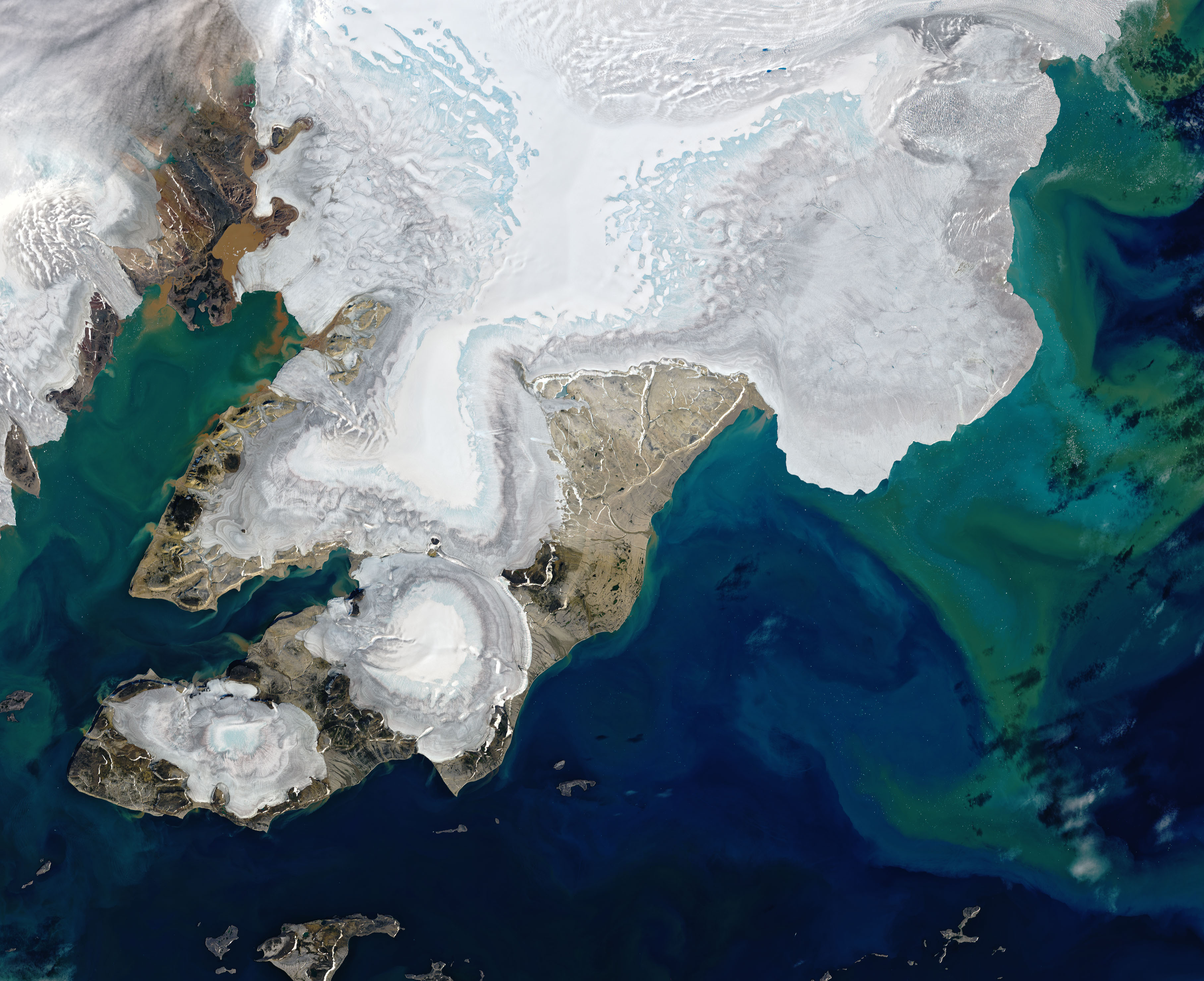
Svalbard is one of the fastest warming places on the planet, according to the National Aeronautics and Space Administration's Earth Observatory. Its satellite photos show record ice melt there this summer, starting with an earlier than normal sea ice melt, has taken "a visible toll."
How global warming happens
Meanwhile, a “highly unusual” heat wave brought warmer winds and temperatures over Greenland from the south, said Martin Stendel, a senior climate scientist at the National Center for Climate Research at the Danish Meteorological Institute. It's a wind pattern similar to the one that brought the heat dome to the Pacific Northwest in 2021.
The polar jet stream is in “a very wave state at the moment,” flowing in a loop over Newfoundland and farther north over western Greenland, then southward again near Svalbard and northern Scandinavia, Stendel said. It’s called an Omega block because it resembles the shape of the Greek letter Omega (Ω).
Warm air inside that loop has been as much as 35 degrees above normal, Stendel said. The warmer air holds more water vapor, so the warmer temperatures dumped more precipitation on Greenland, much of that as rain rather than snow.
Some climatologists suggest summer fluctuations in the jet stream are increasing as the Arctic warms, slowing the jet stream and allowing pressure systems to amplify extremes in heat and rain, while others say more research is needed.
A set of graphs posted by the National Snow and Ice Data Center this week surprised researchers with the burst of warm temperatures and melt seen around much of Greenland’s perimeter Monday.
Almost 40% of Greenland’s ice sheet “experienced melt this past weekend that is exceptionally unusual for this time of year,” said Liam Colgan, a senior researcher at the National Geological Survey of Denmark and Greenland.
According to its data, Southern Greenland’s South Dome – elevation nearly 9,800 feet – ”went above the freezing line into melting temperatures” on Sept. 2, Colgan said. The weather station there recorded a temperature about a half-degree above freezing.
Learn more: Scientists find new population of polar bears hanging on despite rapidly changing climate
Warm blocking wind patterns and hurricane remnants that wind up in the region as extratropical lows do occur naturally, but such precipitation events are becoming more intense, Stendel said. “With generally increasing temperatures, it is probable that such events occur more frequently in the future, thus enhancing sea level rise.”
Colgan and other researchers recently concluded Greenland’s melting ice sheet could add at least a foot of sea level rise to the world’s oceans by 2100.
“Unusually large and late melt events are another signal that the ice sheet is trending towards a warmer climate,” Colgan said. “Hopefully today’s extreme does not become tomorrow’s average.”
On the opposite side of the Omega block, where warm air flows south again, sits Svalbard, a Norwegian archipelago in the Arctic Ocean, where many travel to see polar bears.
Svalbard saw its warmest summer on record in the western and southern end of the islands, Norway’s Meteorological Institute reported. Its 7.4-degree Celsius summer average was .2 degrees hotter than its previous record high in 2020, on Sept. 2.
"There is an end to the 'refrigerator temperature' that you had before, when you could count on keeping food fresh in your rucksack for several days if you were going out on a trip," the Institute said in its update.
The summer average exceeded the previous decade’s average by nearly a full degree, and the previous 30-year average by nearly two degrees.
On the north end of Svalbard, summer heat matched the previous all-time record observed in 2018.

This satellite image of a portion of Nordaustlandet, an island in northeast Svalbard, shows extensive light blue areas where layers of snow have melted away and exposed bare ice, according to NASA. A cluster of small blue dots in the upper right are melt ponds, while colorful water offshore is likely due to sediments eroded by the flow of ice over bedrock and carried by meltwater into the adjacent Arctic Ocean.
LANDSAT 9/NASA AND THE U. S. GEOLOGICAL SURVEY
Svalbard is one of the fastest warming places on the planet, according to the National Aeronautics and Space Administration's Earth Observatory. Its satellite photos show record ice melt there this summer, starting with an earlier than normal sea ice melt, has taken "a visible toll."
How global warming happens
No comments:
Post a Comment