Hannah Osborne
Tue, November 14, 2023
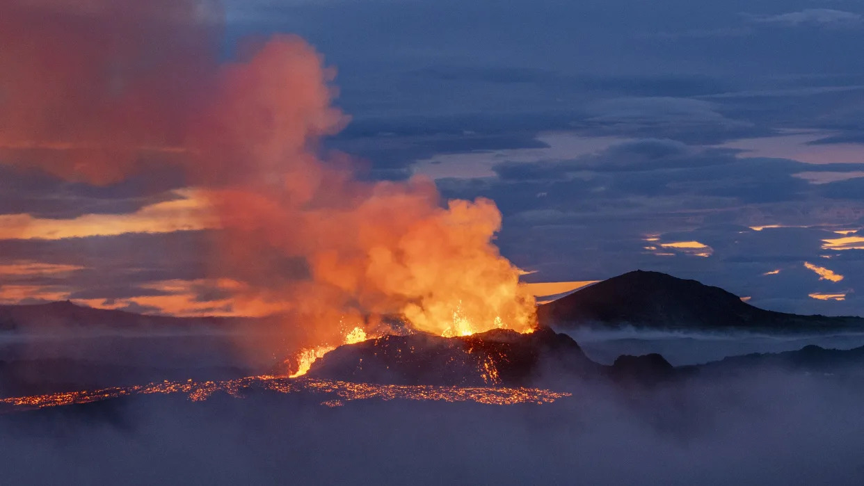
Fagradalsfjall volcano in Iceland erupting at dusk
Iceland's potentially imminent eruption in the Reykjanes Peninsula is part of a 1,000-year cycle of volcanic activity that will likely cause eruptions for centuries, scientists say.
"Time's finally up," Edward W. Marshall, a researcher at the University of Iceland's Nordic Volcanological Center, told Live Science in an email. "We can get ready for another few hundred years of eruptions on the Reykjanes."
Seismic activity began increasing in the south of the peninsula in October, with hundreds of earthquakes recorded there each day. On Nov. 10, authorities evacuated the town of Grindavík, with experts warning an volcanic eruption could take place in just days.

Infographic showing the seismic activity that has hit Iceland in recent weeks
According to the Icelandic Met Office (IMO), a magma tunnel stretching 9.3 miles (15 kilometers) formed beneath the ground between Sundhnúkur in the north and Grindavík. The area affected also encompasses the Blue Lagoon geothermal spa — a tourist hotspot that attracts hundreds of thousands of visitors annually.
Related: Underwater volcanic eruption gives birth to new island in the Pacific
Magma in the tunnel — also known as a dike — appears to be rising to the surface, and there is a high risk of it breaking through. The greatest area of magma upwelling is currently close to Sundhnúkur, about 2 miles (3.5 km) northeast of Grindavík, according to the IMO. Researchers believe the amount of magma in the tunnel is "significantly more" than what was present during the eruptions at Fagradalsfjall, which sparked back to life in 2021 after more than 800 years of inactivity.
That 2021 eruption marked the start of a new cycle of volcanic activity on the Reykjanes Peninsula. Geological records show periods of inactivity last between 600 and 1,200 years, which is then followed by pulses of eruptions lasting between 200 and 500 years, Clive Oppenheimer, a professor of volcanology at the University of Cambridge in the U.K., told Live Science in an email.
"It looks like 2021 kicked off a new eruptive phase which might see the several fault zones crossing the [Reykjanes Peninsula] firing on and off for centuries," he said.
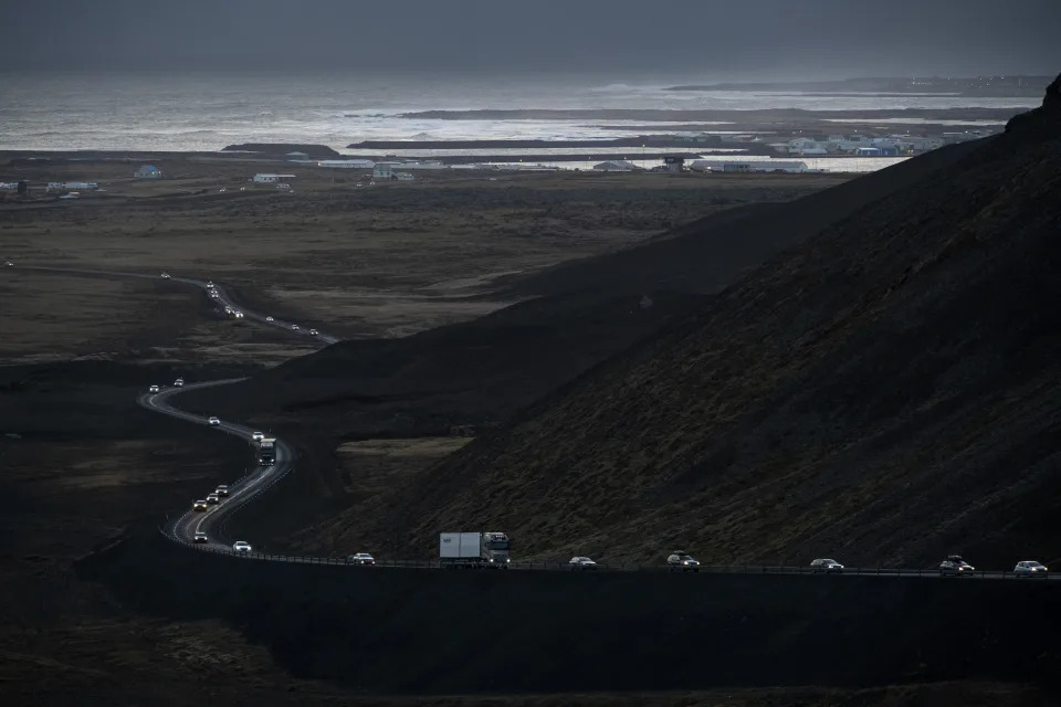
vehicles leaving the town of Grindavik, southwestern Iceland, during evacuation following earthquakes., with the sea in the background
The Reykjanes Peninsula sits above two tectonic plates that are being pulled apart. The strain that builds up is released in bursts as part of the cycle. "We are now in one of these pulses," David Pyle, a volcanologist and professor of Earth sciences at the University of Oxford, U.K, told Live Science in an email. "Each eruption releases just a bit more of the stored-up strain, and eventually, when all of that strain has been released, then the eruptions will stop."
RELATED STORIES
—California's supervolcano has a massive lid that causes swarms of earthquakes — and that's a good thing, scientists say
—Perilous expedition to uninhabited island in South Atlantic confirms existence of world's 8th lava lake
—Volcanoes like Kīlauea and Mauna Loa don't erupt like we thought they did, scientists discover
It is currently unclear if an eruption will take place as a result of the magma tunnel. "These sorts of dikes are actually a tectonic, not a magmatic feature. In other words, the lava is filling a fracture, not forcing its way into the rock," Marshall said.
Should a fissure emerge, an eruption could last for several weeks. The large amount of magma involved compared with previous eruptions in the region could result in more lava flow at the surface, Oppenheimer said.
What happens next is a waiting game, Marshall said. "I predict — if an eruption occurs — that it will occur between a few days to threeish weeks. If it hasn't erupted in three weeks, I don't think it will happen. Cooling will begin to close the fractures."
Iceland volcano: Peninsula faces 'decades' of instability
Jessica Parker - in Reykjavik
Thu, November 16, 2023

Iceland has some "ingenious ways" to fight lava, says Dr Roberts, but he concedes "nature always wins if the eruption is long enough"
Iceland's south-western peninsula could face decades of volcanic instability, warns the Icelandic Met Office (IMO).
Earthquakes and fears of an impending eruption have led to the evacuation of the small fishing town of Grindavik.
After an 800-year hiatus, eruptions on the Reykjanes Peninsula began again in 2021, which may mark a new "eruptive cycle", the IMO's Matthew Roberts says.
"We expect to see volcanic eruptions along the peninsula, not just repeatedly in the same location."
This instability, he adds, could last decades.

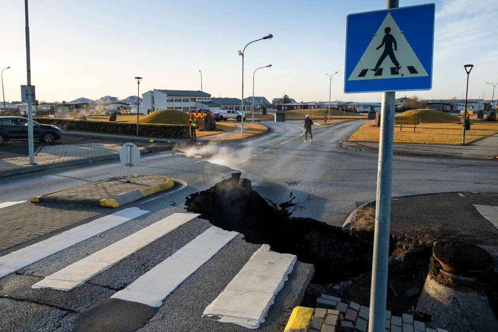
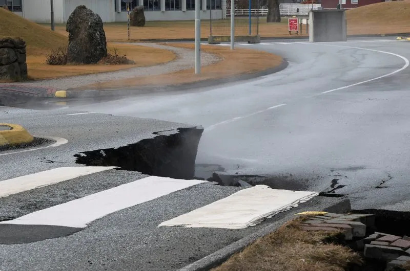
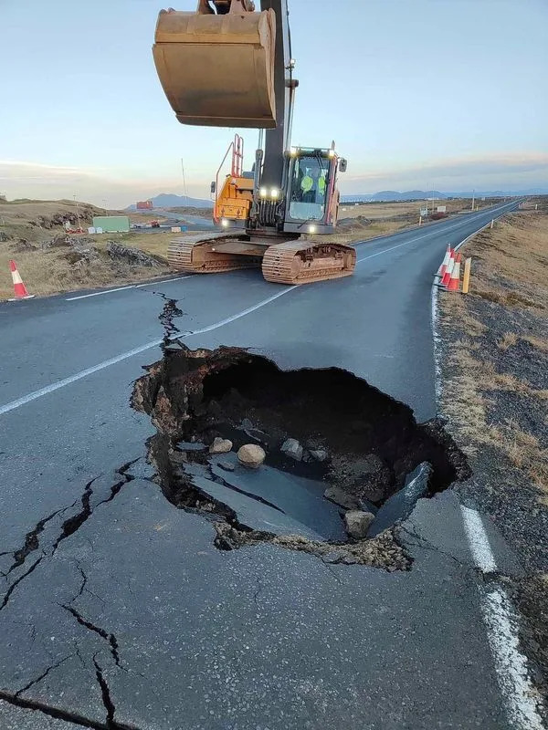
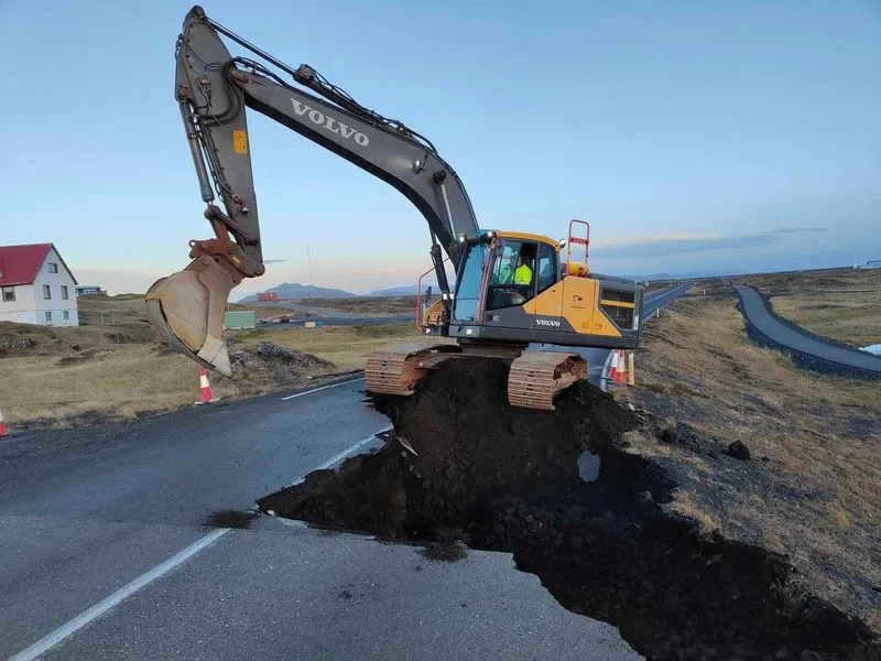
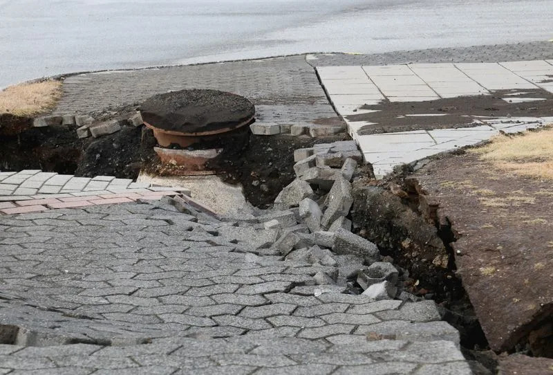
Huge cracks have appeared on the roads of Grindavik, as the fishing town continues to sink every day
Dr Roberts, who is a managing director in the IMO's Reykjavik headquarters, takes us into a room where staff are intensely monitoring seismic activity 24 hours a day.
Last Friday, the team were shocked to realise magma was coursing into the ground, fracturing rock over a distance of 15km (nine miles).
It cut beneath Grindavik "almost like an underground freight train", says Dr Roberts. A phenomenon unknown in modern times.
The order was quickly given to evacuate, and soon after stark images began emerging of severely cracked roads and damaged houses following repeated earthquakes.
The town will continue to subside, Dr Roberts says, exacerbating damage to buildings and roads.
The western part of Grindavik has sunk by more than a metre (3.3ft) since last Friday, and continues to do so at a rate of about 4cm (1.6in) a day.

The situation is being monitored by IMO experts 24 hours a day
A colour map shows the recent levels to which land has collapsed and in one area the situation remains "highly volatile", with an eruption likely within days or weeks.
If there is an eruption, there could be significant damage to local infrastructure and a release of toxic fumes.
Fascinatingly, aerial photographs suggest that the magma is running underneath a previous, centuries-old, visible fissure.
"The magma intrusion is exploiting this exact same location again," says Dr Roberts.
Iceland is very used to volcanic activity because it sits over the Mid-Atlantic Ridge. The Eurasian and North American plates are pulling apart from each other, a few centimetres each year.
But this kind of evacuation of an entire community has not happened in 50 years.
In 1973, a fissure started spouting molten red lava on Heimaey, the largest of Iceland's Westman Islands.
Currently, within the Reykjanes Peninsula, it is estimated that the magma is now sitting about 800m (0.5 miles) beneath the surface.
Residents may have to wait for weeks, at least, before it is clear whether they can return to the area.
"We're not expecting an explosive eruption," says Dr Roberts, although that is not necessarily a good thing.
A low-intensity eruption could mean lava pouring from a series of fissures over weeks and weeks.
"If that were to occur there would be lava flow to the south - possibly towards Grindavik - and also possibly north and westwards" towards the Svartsengi power station and Blue Lagoon, says Dr Roberts.
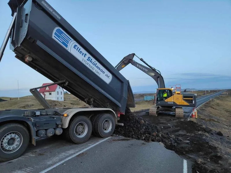
Contingency plans include protective barriers - known as "levees" - which are being built near the geothermal plant while the famous Blue Lagoon spa remains closed.
Iceland has all sorts of ingenious ways to fight lava, says Dr Roberts, but "nature always wins if the eruption is long enough".

Map of Reykjanes peninsula
A Volcano in Iceland Could Erupt Any Day. Here’s What to Know
Mallory Moench
Wed, November 15, 2023
Iceland is preparing for a possible volcanic eruption after hundreds of small earthquakes have rocked the island nation in the North Atlantic. Seismic activity has fissured roads, shut down tourist attractions and led the government to evacuate a town in the potential path of an eruption.
Iceland averages a volcanic eruption every five years, the country’s tourism board said. Three eruptions in the past three years occurred on the same peninsula where activity is being monitored, the government said, without harming people or disrupting flights.
That hasn’t always been the case, though. Another Icelandic volcanic eruption in 2010 sent clouds of ash into the atmosphere and crippled air travel across Europe off and on for a month.
Here’s what we know about the unfolding situation in Iceland.
What’s happening in Iceland?
Seismic activity near Grindavík, which is about 31 miles (50 km) southwest of the capital Reykjavik, began around Oct. 25, but took a sudden worrying turn on Nov. 10, raising the risk of a volcanic eruption, according to the Icelandic Met Office.
The office has warned of a “significant likelihood of a volcanic eruption in the coming days.” On Nov. 14 alone, meteorologists tracked more than 700 earthquakes near the volcano, the office said.
“The likelihood of a volcanic eruption is high and an eruption could be possible on a timescale of just days,” the Icelandic Association for Search and Rescue’s website SafeTravel warns, explaining that the eruption is likely to occur on land just outside Grindavík, with some chance of an undersea explosion as well.
What is the risk for people in Iceland?
The government declared a state of emergency and evacuated Grindavík, a fishing village with a population of 3,400, on Nov. 11 after determining that magma extended beneath the surface of the town, the Associated Press reported.
Earthquakes opened up deep cracks in the roadways west of Grindavík on Nov. 13, closing the streets and making travel impossible for the foreseeable future, according to the Icelandic Road and Coastal Administration.
Will this have an impact on travel?
In recent years, Iceland has become a more popular tourist destination and growing transit hub for flights from North America to Europe. In 2010, the eruption of the Eyjafjallajokull volcano spewed clouds of ash into the atmosphere and caused a month of travel disruption with flights being grounded and re-routed.
The volcano currently under watch had not erupted at the time of publication, so there are no current impacts to flight operations at Keflavik Airport in Reykjavik. All roads to the airport are open, the government said. The airport is only about 18 miles (31 km) from the evacuated town.
Iceland’s tourism website said it’s impossible to conclude whether flight travel will be impacted if the volcano erupts, but added that “while the possibility of air traffic disturbance cannot be entirely ruled out, scientists consider it an unlikely scenario.”
“The potential disruption to flight traffic would depend on factors such as the location and size of the eruption. Typically, the impact of volcanic eruptions is confined to specific, localized areas,” the agency said.
The agency pointed out that three eruptions on the Reykjanes Peninsula, where the currently active volcano is located, in the past three years didn’t impact flight travel.
The U.K. and U.S. governments have warned citizens and tourists about traveling to Iceland at this time. The country’s popular Blue Lagoon tourist attraction closed last week as earthquakes rattled the area.
How can we help people impacted by the situation in Iceland?
The International Federation of Red Cross and Red Crescent Societies said it was caring for hundreds of evacuees in shelters as of Nov. 14. The organization’s local branch, the Icelandic Red Cross, has launched an emergency fundraising campaign to support their efforts.
Iceland volcano LIVE: Authorities create makeshift defenses to protect geothermal power plant
Hannah Osborne
Wed, November 15, 2023

Fagradalsfjall volcano in Iceland erupting at dusk .
Iceland is bracing for an imminent volcanic eruption on the Reykjanes Peninsula, in the southwest corner of the island. Grindavík, a small fishing town with a population of around 2,800 people, has been evacuated after a sinkhole measuring 3.2 feet (1 meter) deep appeared in the town.
Seismic activity began increasing in the area on Oct. 25, when more than 1,000 earthquakes north of Grindavík occurred in the space of just hours. Two strong earthquakes, measuring magnitudes 3.9 and 4.5, hit at a depth of around 3 miles (5 kilometers). Over the following two weeks, seismic activity continued, with hundreds of earthquakes and uplift recorded each day, indicating that magma is accumulating beneath the ground.
On Nov. 11, Icelandic Met Office (IMO) data showed there was a "magma tunnel" about 9.3 miles (15 km) from Sundhnúk in the north down to Grindavík and into the sea. Experts say an eruption could take place anywhere along this tunnel — also known as a dike.
Timeline of events:
Nov. 10 — Grindavík evacuated due to the increase in seismic activity gravitating towards the fishing vilage. Icelandic authorities declare a state of emergency
Nov. 9 — The largest recorded earthquake since the swarm began reaches a magnitude of M4.8. Blue Lagoon geothermal resort, one of the country's most famous tourist attractions, is temporarily closed.
Nov. 4 — Seismic activity decreases considerably, but Icelandic Meteorological Office continues to monitor the situation.
Oct. 25 — Seismic activity in the Reykjanes Peninsula increases with more than 1,000 earthquakes registered in the area, the largest with a magnitude of M4.5.
'Time's finally up': Impending Iceland eruption is part of centuries-long volcanic pulse

A volcano pictured at dusk spewing lava, dust and ash
Iceland's potentially imminent eruption in the Reykjanes Peninsula is part of a 1,000-year cycle of volcanic activity that will likely cause eruptions for centuries, scientists say.
"Time's finally up," Edward W. Marshall, a researcher at the University of Iceland's Nordic Volcanological Center, told Live Science in an email. "We can get ready for another few hundred years of eruptions on the Reykjanes."
Seismic activity began increasing in the south of the peninsula in October, with hundreds of earthquakes recorded there each day. On Nov. 10, authorities evacuated the town of Grindavík, with experts warning an volcanic eruption could take place in just days.
'Time's finally up': Impending Iceland eruption is part of centuries-long volcanic pulse
800 earthquakes recorded since midnight
Around 800 earthquakes have been recorded since midnight, Nov. 15. Most hit at the center of the magma dike, according to a translated statement from the IMO.
The continuing ground deformation is likely being caused by magma flowing into the dike, experts say
"Part of the magma dike seems to be solidifying, especially at the edges, but not at the magma inflow area, which is believed to be near Sundhnúk," according to the statement. "The probability of an eruption is still considered high. In the event of an eruption, the most likely location is at the magma dike."
Officials scramble to protect vital power plant from imminent lava flows

A geothermal power plant in Iceland with steam rising from vents
On Tuesday (Nov. 14), Icelandic authorities started creating makeshift defenses to protect the Svartsengi geothermal power plant from lava flows that may emerge if the magma dike erupts over the next few days, Reuters news agency reported.
The Svartsengi plant uses heat from the underground magma in the region to heat water and turn turbines. It is located around 4 miles (6 km) from Grindavík, which has been evacuated over fears of the imminent eruption, and supplies power across the country, as well as hot water to the local area.
Workers have begun digging out channels to divert the lava away from the plant if molten rock heads in that direction
Iceland prepares to shield geothermal plant from risk of volcanic eruption
Updated Tue, November 14, 2023
By Ben Makori
GRINDAVIK, Iceland (Reuters) -Icelandic authorities were on Tuesday preparing to build defence walls around a geothermal power plant in the southwestern part of the country that they hope will protect it from lava flows amid concerns about an imminent volcanic eruption.
Seismic activity and underground lava flows intensified on the Reykjanes peninsula near the capital Reykjavik over the weekend, prompting authorities to evacuate nearly 4,000 people from the fishing town of Grindavik on Saturday.
The probability of an eruption remained high despite a decrease in seismic activity, the Icelandic Meteorological Institute said in a statement on Tuesday.
Nearly 800 earthquakes were recorded in the area between midnight and noon on Tuesday, fewer than the two previous days, it said.
"Less seismic activity typically precedes an eruption, because you have come so close to the surface that you cannot build up a lot of tension to trigger large earthquakes," said Rikke Pedersen, who heads the Nordic Volcanological Centre based in Reykjavik.
"It should never be taken as a sign that an outbreak is not on the way," she said.
Authorities said they were preparing to construct a large dyke designed to divert lava flows around the Svartsengi geothermal power plant, located just over 6 kilometres (4 miles) from Grindavik.
Justice Minister Gudrun Hafsteinsdottir told state broadcaster RUV that equipment and materials that could fill 20,000 trucks were being moved to the plant.
Construction of the protective dyke around the power station was awaiting formal approval from the government.
A spokesperson for HS Orka, operator of the power plant, said it supplies power to the entire country, although a disruption would not affect power supply to Reykjavik.
Almost all of Grindavik's 3,800 inhabitants were briefly allowed back to their homes on Monday and Tuesday to collect their belongings, Iceland's department of civil protection and emergency management said.
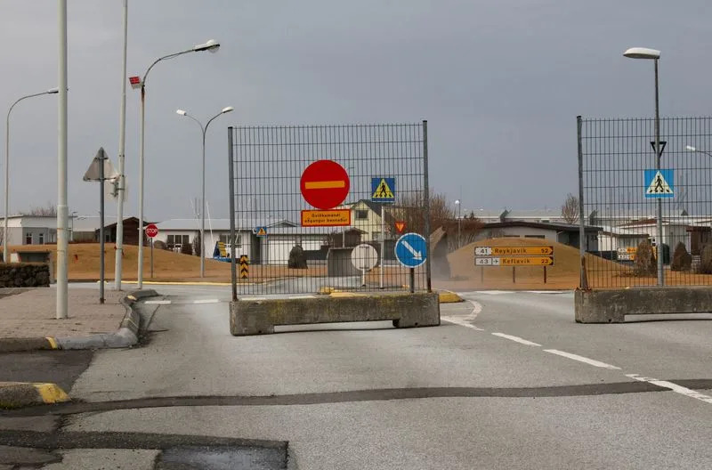
In Grindavik, long cracks ran through the town centre, leaving its main street impassable, while steam could be seen rising from the ground.
Some of the houses still had their lights on, but the town was deserted beyond the odd car and a handful of locals there to collect their most important belongings before Grindavik was once again declared out of bounds.
Local resident Kristin Maria Birgisdottir, who works for the town municipality, told Reuters on Tuesday she only had the clothes she had worn for work on the day the town was evacuated.
"I'm getting prepared in case I get a chance to visit my house and get some of my belongings," said Birgisdottir, who has moved to a summer house with her family.
Some residents had to be driven into Grindavik in emergency responders' vehicles, while most inhabitants were allowed to drive into Grindavik in their private cars accompanied by emergency personnel.
Most pets and farm animals had been rescued from Grindavik by Monday night, according to charity Dyrfinna.
During the afternoon, new metres installed near Grindavik by the meteorological office detected elevated levels of sulphur dioxide, leading Grindavik to again be fully evacuated at short notice slightly ahead of schedule.
The agency said in an update that while there were no other indications of an eruption starting, it could not be ruled out since the gas does not appear unless magma is high in the earth's crust.
(Additional reporting by Louise Breusch Rasmussen, Johannes Gotfredsen-Birkebaek, Jacob Gronholt-Pedersen and Niklas Pollard; editing by Christina Fincher, Alex Richardson, Mark Heinrich, Alexandra Hudson)
No comments:
Post a Comment