CLIMATE CRISIS
Signal No. 4 raised over northern islands, thunderstorms in Manila, surrounding provinces
Signal No. 4 is the second-highest alert level and indicates extremely strong winds and potential devastation.
IT IS MOVING TOWARD TAIWAN
Published: September 30, 2024
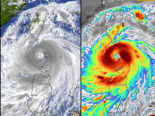
Forecasters warned the tropical cyclone Krathon could further intensify into "supertyphoon" category, by tomorrow, Tuesday.Image Credit: Himawawi-9
Manila: A powerful typhoon packing winds of 175 kilometres per hour (km/h) near the centre and gustiness of up to 215 km/h is threatening a number of Philippine provinces on mainland Luzon and the northern islands, forecasters said.
The Pagasa weather bureau said "Krathon" (local code: "Julian") may make landfall over Balintang Island or Batanes on Monday (September 30, 2024).
Supertyphoon
Forecasters also warned the tropical cyclone could further intensify into "supertyphoon" category, as it was seen moving west-northwestward at 10 kph.
Tropical Cyclone Wind Signal (TCWS) Number 4 was already raised over Batanes and the northern portion of Babuyan Islands, home to about 19,000 people.
Signal No. 4 is the second-highest alert level and indicates extremely strong winds and potential devastation.
TYPHOON BELT
On average, the Philippines is hit by 20 typhoons annually, with about 5 to 7 of them being particularly destructive.
The typhoon season in the Philippines typically occurs from June to November, with peak activity usually between July and October.
During these months, the country experiences the majority of its typhoons due to the southwest monsoon (locally known as "Habagat").
However, typhoons can still form outside this period, as the Philippines is located in a region prone to tropical cyclones year-round.
Manila, Central Luzon affected
A weather bulletin issued at 2.13 pm, meanwhile, warned of rainshowers, lightning over Central Luzon and Calabarzon.
Moderate to heavy rainshowers with lightning and strong winds are expected over Pampanga, Laguna, Quezon, Metro Manila and Batangas within the next 2-3 hours, Pagasa stated.
The above conditions are being experienced in Zambales (Santa Cruz, Candelaria, Masinloc), Bataan (Dinalupihan, Balanga, Abucay, Samal, Orani, Hermosa, Morong, Bagac), Bulacan (Dona Remedios Trinidad), Tarlac (Moncada, Anao, San Manuel), Nueva Ecija (Nampicuan, Cuyapo, Talugtug), Cavite (Silang, Amadeo, Dasmarinas, General Trias) and Rizal (Pililla, Jala-Jala, Tanay, Cardona, Binangonan).
Hazards
“All are advised to take precautionary measures against the impacts associated with these hazards which include flash floods and landslides,” Pagasa warned, adding the weather pattern may persist within 2 hours and may affect nearby areas.
In an earlier bulletin issued on Monday, Pagasa said the following areas in Luzon are under the following Tropical Cyclone Wind Signals:
TCWS No. 4
Batanes;
Northern portion of Babuyan Islands (Babuyan Island, Calayan Island)
TCWS No. 3
The rest of Babuyan Islands;
Northeastern portion of mainland Cagayan (Santa Ana)
TCWS No. 2
The rest of mainland Cagayan;
Apayao;
Northern portion of Abra (Tineg, Lacub, Malibcong, Licuan-Baay, San Juan, Lagayan, Lagangilang, Dolores, Daguioman, Danglas, La Paz);
Northern portion Kalinga (Pinukpuk, Balbalan, City of Tabuk, Rizal);
Ilocos Norte; and
The northern portion of Ilocos Sur (Sinait, Cabugao)
TCWS No. 1
the rest of Ilocos Sur; La Union; Pangasinan;
the rest of Abra; the rest of Kalinga; Ifugao;
Mountain Province;
Benguet;
Isabela;
Nueva Vizcaya;
Quirino;
Aurora;
The northern eastern portions of Nueva Ecija (Cuyapo, Rizal, Laur, Pantabangan, Science City of Muñoz, Gabaldon, Carranglan, San Jose City, Lupao, Talugtug, Bongabon, Llanera, Talavera, Palayan City, General Mamerto Natividad); and Polillo Islands.
“Julian (Krathon) is forecast to move generally west northwestward over the Balintang Channel today and pass very close to Balintang Island and Batanes. A landfall scenario over these areas remains likely. Nevertheless, this typhoon will be at its closest to Batanes and Babuyan Islands this morning through afternoon,” Pagasa said.
“Julian (Krathon) will continue intensifying and may reach super typhoon category tomorrow at the start of its recurvature. Interaction with the rugged terrain of Taiwan will trigger a weakening trend prior to landfall, although Julian is forecast to remain as a typhoon until it exits the PAR region,” it added.
Thunderstorm warnings:
2:13 pm (Monday, Sept 30): Pagasa issued Thunderstorm Advisory No. 17 for several regions, including Metro Manila.
Affected Areas: Pampanga, Laguna, Quezon, Metro Manila, and Batangas can expect moderate to heavy rain with lightning and strong winds within the next 2-3 hours.
Additional Information: Similar conditions are already occurring in parts of Zambales, Bataan, Bulacan, Tarlac, Nueva Ecija, Cavite, and Rizal. These areas may experience flash floods and landslides.
Stay informed:
Monitor Pagasa’s website and social media channels for the latest updates on Typhoon Julian (Krathon) and other weather disturbances. Take necessary precautions based on the warnings issued by Pagasa.
No comments:
Post a Comment