An investigation of the DNA of the crew of King Henry VIII's battleship 'Mary Rose', which sank in 1545, reveals more diversity than historians expected.
Stuart McDill reports.
Sunday, June 23, 2019
Saturday, June 22, 2019
A 12-foot alligator was found on a Florida highway: 'He wasn't happy'

MarKeith Cromartie
June 20, 2019

TALLAHASSEE, Fla. – It's not every day you see a 12-foot, 463-pound alligator wandering on an interstate. But that was the case earlier this month in Florida.
Broderick Vaughan, who has been trapping nuisance alligators in Leon County, Florida, for nearly 10 years, was in awe when he got the call about the behemoth wandering on Interstate 10 in Tallahassee.
“I’ve been the trapper here in Leon County since April 2010 and that was the third-biggest gator I’ve captured,” said Vaughan, the owner of Vaughan’s Gators. “That was a pretty big one and he wasn’t happy that we were trying to remove him.”
The Tallahassee Police Department and Florida Highway Patrol responded to calls at about midnight on June 3 about the massive reptile. The exit had to be closed for a few hours to keep drivers away from the huge gator, which had apparently wandered onto the highway.
The alligator was injured after being hit in the snout by a semi-truck. It was stunned and walking in circles when law enforcement officers arrived.
Vaughan was called and arrived less than an hour later. He was able to wrap his snare pole around the tired creature, tape its snout shut and load it on his truck using a hoist machine.
The gator was safely removed, but it had to be euthanized later because of the severity of its injuries.
Old spy images show just how fast ice is melting from the glaciers in the Himalayas
Climate Intelligence Agency CIA
Picture 3 million Olympic-size swimming pools full of water.
That's how much ice melts from glaciers in the Himalayas each year, a new study suggests, and climate change is the primary cause.
Even more concerning is that the ice melt has doubled in recent years: Himalayan glaciers have been losing the equivalent of more than a foot and half of ice each year since 2000 – which is double the amount of melting that took place from 1975 to 2000.
“This is the clearest picture yet of how fast Himalayan glaciers are melting over this time interval and why,” said study lead author Joshua Maurer, a Ph.D. candidate at Columbia University’s Lamont-Doherty Earth Observatory.
Overall, the Asian mountain range, which includes Mount Everest, has been losing ice at a rate of about 1% a year since 2000.
The big melt: Global warming predicted to melt massive Himalayan glaciers, disrupt food production
The melting also threatens the water supplies for hundreds of millions of people downstream who rely on it for hydropower, agriculture and drinking, across a large portion of Asia, said study co-author Jorg Schaefer, a climate geochemistry professor at Columbia.
“Disaster is in the making here,” Schaefer said.
Scientists used recently declassified Cold-War-era 3D satellite images to track the glacial retreat back to the mid-1970s. By analyzing 650 Himalayan glaciers, the researchers estimate that, of the region’s total ice mass present in 1975, 87% remained in 2000, and 72% remained in 2016.
READ ON
READ ON

FOR SOME THE COLD WAR WAS A REAL WAR
South Korea Jeju Massacre haunts the memories of survivors
Ko Wan-soon was only 9 when an anti-communist South Korean "soldier" smashed the skull of her 3-year-old brother with a club.
Ko Wan-soon was only 9 when an anti-communist South Korean "soldier" smashed the skull of her 3-year-old brother with a club.
UNITED NATIONS, June 20 (UPI) -- Ko Wan-soon was only 9 when an anti-communist South Korean "soldier" smashed the skull of her 3-year-old brother with a club, as anti-communist forces terrorized their village and executed civilians.
Ko, an "80-year-old grandmother," is a witness and survivor of one of the most brutal massacres in South Korean history. At the U.N. Symposium on Human Rights and Jeju 4.3 on Thursday, she called for awareness of the Jeju Massacre, or Jeju Uprising, when tens of thousands of victims may have been killed in the South while detained or tortured at the hands of anti-communist police from 1948 to 1954.
Bruce Cumings, the influential U.S. historian of Korea at the University of Chicago, said at the symposium the killings were undertaken by young men who had been kicked out of northern Korea by communists. Some of them formed the Northwest Youth League in the South and began to embark "on a campaign of terror in order to defeat communism" on Jeju Island, Cumings said.
Cumings, who once dubbed the massacre "our Srebrenica" in a book on the 1950-53 Korean War, said the U.S. military, which maintained operational control of the South's military and national police after Japan's surrender, had a role in the suppression during the massacre.
"The United States ruled Korea, even experts seem unaware," Cumings said.
"But the United States is seen as a kind of innocent bystander" to what took place, the historian said.
Cumings also said in classified U.S. documents that U.S. intelligence appeared aware, but documents show "very little mention of outrage about the slaughter."
U.S. officials instead praised first South Korean President Syngman Rhee's "vigorous" anti-communism in the documents, favoring his hard-line policies over those of Chiang Kai-shek, the leader of the Republic of China.
"It made me ashamed," he said.

The 4.3 Peace Park on Jeju Island, South Korea includes exhibits of how victims were tortured or killed during a massacre that has been kept hushed-up for decades in the country.

UPI.COM
UPI.COM
Thursday, June 20, 2019


Wednesday, June 19, 2019


ACTUAL FRESH LAKE MONSTER

Continued from Part 1
CRYPTID #LAKEMONSTER #CRYPTOZOOLOGY #FOSSILFISH #PREHISTORICFISH #STURGEON #ENDANGEREDSPECIES
Is the Royal Canadian Navy Missing a Great Opportunity?
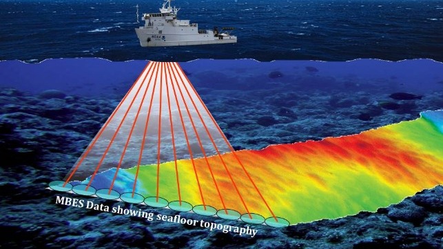
Hydrographic surveys are required to produce nautical charts, and updated surveys allow for safer and more efficient marine transportation in Canada’s northern waters.
At a recent Canadian Maritime Advisory Council meeting in Ottawa, I was disappointed to learn again that the Royal Canadian Navy still had no plan to install multi-beam echo sounders (MBES) on the Arctic offshore patrol ships (AOPS) which are under construction now.
I was also concerned with the fact that only approximately eight percent of the Canadian Arctic has been surveyed to modern standards and only a total of about 14 percent is done to a modern or adequate standard. Hydrographic surveys are required to produce nautical charts, and updated surveys allow for safer and more efficient marine transportation in Canada’s northern waters.
To assist the Canadian Hydrographic Service increase the percentage of Arctic oceans done to modern or adequate standards, the Canadian Coast Guard has already equipped four of its icebreakers with MBES; with two more planned and funded for the CCGS Henry Larson and CCGS Pierre Radisson to take place in the next two years.
Retrofitting AOPS with MBES will obviously be more expensive than if the systems were installed while under construction. That would naturally require minor modifications to the existing plans, but it would be more cost effective in the long-run. The funding could potentially come in part from the important and successful Ocean Protection Plan.
Traffic is rapidly increasing with the fast disappearing Arctic ice. The summer of 2018 saw a total of 167 ships entering the Arctic and completing more than 400 voyages. More traffic will naturally lead to more marine accidents in poorly surveyed areas of the Arctic. On August 17, 2018, the cruise ship Akademik Ioffe ran aground in a poorly charted area of the western Gulf of Boothia near Kugaaruk, Nunavut. Two of the five Canadian Coast Guard icebreakers in the Arctic were dispatched to provide assistance. Fortunately, there were no casualties and only minor environmental damage.
One could argue that the best way to do search and rescue is to prevent accidents in the first place. Modern marine charts will certainly contribute to reduce the possibility of more grounding. The Akademik Ioffe was the third cruise ship to run aground in the Canadian Arctic after the MV Clipper Adventurer in 2010 and Hanseatic in 1996. With increasing activity in poorly-charted areas, our luck may soon run out.
When Coast Guard vessels are dispatched for a search and rescue mission they may not be available to support the essential annual sealift to the Arctic communities. A delay in delivering the annual sealift for a lack of icebreaking support will cost the shipping companies. If the sealift cannot take place there will be significant impacts. Last summer, when a multi-year ice plug blocked some of the resupply of a few western communities, some construction projects had to be delayed by one year and the cost of airlifting the essential goods was in the millions of dollars.
The AOPS will be patrolling the Arctic. Would it not be great if they could carry out both opportunistic and targeted hydrographic surveys while patrolling in Arctic waters? When operating in poorly surveyed areas, those ships could be proceeding forward at slow speed. It seems to be one of the tailor-made tasks for those ships.
Accurate charts will bring significant benefits. More efficient routing for the resupply of communities will reduce the cost for operators and reduce the environmental impact by reducing ship emissions. It would allow those ships to circumvent ice blockages safely using alternative routes surveyed and charted. Search and rescue could be done faster by allowing ships to take more direct routes and to proceed safely at the best speed. Accurate charts would contribute to the commitments made by Canada to improve its search and rescue capacity under the Arctic Council’s Arctic Search and Rescue Agreement.
The Royal Canadian Navy has helped in the past with temporary MBES systems on the Kingston-class Marine Coastal Defence Vessels. That could be an option for the AOPS except that towed systems have limitations especially in ice-infested waters. They would similarly require modifications to the brand new vessels to mount the required hardware. Inboard systems, designed and installed during ship building, are by far the preferred solution.
The patrolling and mapping of the waters in the Arctic Archipelago will also have an important sovereignty dimension.
Pierre Leblanc is a retired colonel and former commander of the Joint Task Force North and program manager of the North Warning System. He is also with Arctic Security Consultants.
This article was originally published in The Hill Times.
Subscribe to:
Posts (Atom)