New round of smoke from Canada fires prompts air quality alerts across the Upper Midwest
By Sara Smart, Taylor Ward and Aya Elamroussi, CNN
Published 12:12 AM EDT, Thu June 15, 2023
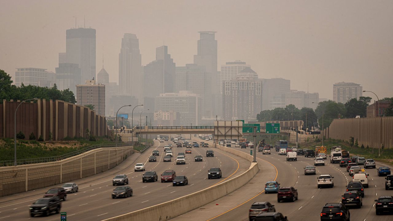
A haze enveloped Minneapolis as seen from the south across I-35W on Wednesday.Glen Stubbe/Star Tribune/Getty Images
CNN —
Thick plumes of smoke from dozens of wildfires raging in Ontario, Canada, are billowing across the US border, compromising the air quality for millions of residents in Wisconsin and Minnesota.
The entire state of Minnesota and most of Wisconsin were under air quality alerts Wednesday as a gray haze from wildfire smoke shifted south, according to the National Weather Service.
Parts of both states experienced air quality marked as “unhealthy” or “very unhealthy” on Wednesday afternoon – levels 4 and 5 out of 6, according to the monitoring website AirNow.
“Smoky skies and poor air quality will continue through Thursday with the worst conditions expected tonight,” the National Weather Service in the Twin Cities said Wednesday.
By Thursday morning, air quality should begin improving as the smoke clears, the weather service in Duluth, Minnesota, said.
The air quality alert in Minnesota has been extended through Friday morning because smoke might take time to dissipate, according to the Minnesota Pollution Control Agency. The air quality alert in Wisconsin is in effect until noon local time Thursday.
In Canada, at least 63 wildfires are spread across Ontario, where the worst conditions are in the northwest region while the northeast is experiencing less significant fire hazards, a wildfire map shows.
For most areas in Ontario, the air quality health index was observed as “low risk” Wednesday, ranging from level 2 to 3 of 10, according to the country’s air quality monitoring website.
Meanwhile, areas including Chatham, downtown Toronto and Windsor had an air quality health index of moderate, which is level 4 of 10. Those areas are also forecast to improve over the next couple of days. Montreal in Quebec faces a forecast of moderate risk with level 5 of 10 on Thursday.
By Sara Smart, Taylor Ward and Aya Elamroussi, CNN
Published 12:12 AM EDT, Thu June 15, 2023
A haze enveloped Minneapolis as seen from the south across I-35W on Wednesday.Glen Stubbe/Star Tribune/Getty Images
CNN —
Thick plumes of smoke from dozens of wildfires raging in Ontario, Canada, are billowing across the US border, compromising the air quality for millions of residents in Wisconsin and Minnesota.
The entire state of Minnesota and most of Wisconsin were under air quality alerts Wednesday as a gray haze from wildfire smoke shifted south, according to the National Weather Service.
Parts of both states experienced air quality marked as “unhealthy” or “very unhealthy” on Wednesday afternoon – levels 4 and 5 out of 6, according to the monitoring website AirNow.
“Smoky skies and poor air quality will continue through Thursday with the worst conditions expected tonight,” the National Weather Service in the Twin Cities said Wednesday.
By Thursday morning, air quality should begin improving as the smoke clears, the weather service in Duluth, Minnesota, said.
The air quality alert in Minnesota has been extended through Friday morning because smoke might take time to dissipate, according to the Minnesota Pollution Control Agency. The air quality alert in Wisconsin is in effect until noon local time Thursday.
In Canada, at least 63 wildfires are spread across Ontario, where the worst conditions are in the northwest region while the northeast is experiencing less significant fire hazards, a wildfire map shows.
For most areas in Ontario, the air quality health index was observed as “low risk” Wednesday, ranging from level 2 to 3 of 10, according to the country’s air quality monitoring website.
Meanwhile, areas including Chatham, downtown Toronto and Windsor had an air quality health index of moderate, which is level 4 of 10. Those areas are also forecast to improve over the next couple of days. Montreal in Quebec faces a forecast of moderate risk with level 5 of 10 on Thursday.
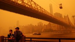
Last week's haze may be just the beginning of a new 'summer of smoke'
In addition to Wisconsin and Minnesota, smoke from the fires was also detected over parts of Kentucky, Illinois, Indiana, Michigan, Ohio and North Dakota as of Wednesday night, another map shows.
The compromised air quality from Canadian wildfires comes just days after dense smoke clouds from wildfires in Quebec last week descended on eastern Canada and a large swath of the US, stretching from the Northeast and Mid-Atlantic to the Ohio Valley and Midwest.
Thick smog wrapped major metro areas including New York City, Philadelphia and Washington, DC, in an orange haze for days. The dense smoke forced officials to close schools, ground flights due to poor visibility, shutter zoos and beaches and pushed many to mask up outdoors.
Scientists warn such events are more likely to continue as the planet warms, creating the ideal environment for more severe and frequent wildfires.
Wildfire smoke is particularly dangerous because it contains tiny particulate matter, or PM2.5, the tiniest of pollutants. When inhaled, it can move deep into lung tissue and enter the bloodstream.
It comes from sources including the combustion of fossil fuels, dust storms and wildfires. Such smoke has been linked to several health complications including asthma, heart disease and other respiratory illnesses.
Predicting and planning for forest fires requires modeling of many complex, interrelated factors
The Conversation
June 14, 2023, 6:59 AM ET

Kinkade Fire California Fires (Justin Sullivan AFP)
Global warming is here. As anticipated for more than 50 years now, the temperature and levels of atmospheric CO2 have increased.
Various models were able to predict these increases with precision, and we are seeing the impact now. One of the main effects of the changes in the atmosphere are frequent forest fires, which are more common globally and have affected Canada in the last month.
Complex models
Mathematical models to predict forest fire behaviors were first introduced in the 1940s and they have been evolving for decades. They consider various aspects and their complex interrelationships: the type of forest fuel (grass, shrub, small trees, large ones), the weather (wind direction, temperature, humidity), the topology of the terrain, and the source of the fire (human activity, lightning).
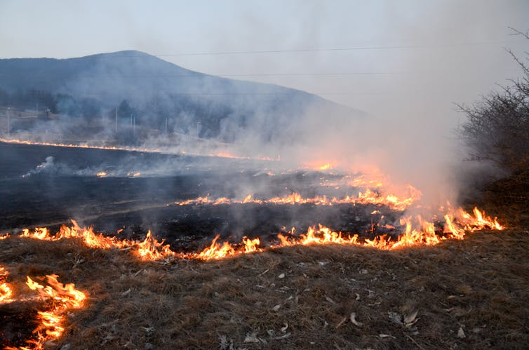
Modeling forest fires and forecasting fire behavior is a complex endeavor. A model can anticipate the direction and intensity of the fire, and help with evacuation, fire suppression and forecast of smoke pollution. The models can predict fire spread, which helps protect human life, housing and infrastructure, including crucial utility companies assets.
Mathematical models are important, but in the case of forest fires, we also need to build simulation tools to be able to handle the complexity. We need to consider the different types of fire fuels in each region, the localized winds within forest fire areas, variations in climate, whether a fire spreads from the crown of the trees or on the ground, and other variations.
Many factors can affect how quickly a fire spreads. (Shutterstock)
Using a computer to build a virtual laboratory for simulations helps with the prediction process in a safe, risk-free and cost-effective fashion. Experiments can be simulated on a computer to inform better decisions in the field, without affecting the environment, people or infrastructure.
Complex factors, small scale
Our lab — the Advanced Real-Time Simulation lab at Carleton University — has been working on new methodologies for modeling and simulation that improve results at a reduced cost.
We model forest fire behavior at a microscopic level. This is because models that work on macro, or larger, scales have some constraints when we want to study the low-level interactions between fire, weather and suppression efforts.
Also, traditional models are harder to interface with Geographical Information Systems (GIS) software applications. We need to be able to interface the models with real-world data coming in real time from a variety of sensors: spectrometers, satellites, infrared scanners, laser or 3D remote sensing devices. Building models that can react to external data needs new methodologies.
Integration of a forest fire model and Geographical Information Systems (GRASS/Google Earth)
Our approach divides the geographical space of a fire into small areas and calculates the complex phenomena. Many existing methods study the spread of fire by dividing the area of interest using a regular topology (for instance, rectangles, squares or triangles over the area of study), but these models are more complex to integrate with GIS, which use polygons of many different shapes. Building models with irregular topologies helps with obtaining more precise results.
These techniques help with creating models that are simpler to understand, test and modify.
Similarly, we need the simulations of such models to run efficiently. We defined new parallel simulation algorithms to generate a larger number of simulations in a shorter period of time, improving the quality of the results.
We also used advanced calculation approaches that include advancing the simulation time irregularly (when important events are detected), as well as techniques to detect higher levels of activity in the simulation. These techniques allow us to pay more attention to the forest fire sections that need more calculations per second, without computing the equations where they are not needed. This saves simulation time and improves precision of the results.
Informed decision-making
Numerous government agencies — such as the U.S.-based National Center for Atmospheric Research — use various modeling and simulation tools like FireSmoke, Fire M3 and FireMars. These tools include web-based support for decision-makers and provide information to the general public.
To improve such tools, advanced research is needed in the field of web-based modelling and distributed simulation, which allows the software to run in remote sites.
Remote execution of forest fire models on mobile devices.
The future of forest fire research includes more sophisticated sensors, new artificial intelligence predictive methods, modeling based on Big Data algorithms and advanced visualization software to enhance the decision-making process.
We need to be prepared for future rounds of forest fires, and modeling and simulation can help in this complex effort.
Gabriel Wainer, Professor, Systems and Computer Engineering, Carleton University
This article is republished from The Conversation under a Creative Commons license. Read the original article.
The Conversation
June 14, 2023, 6:59 AM ET
Kinkade Fire California Fires (Justin Sullivan AFP)
Global warming is here. As anticipated for more than 50 years now, the temperature and levels of atmospheric CO2 have increased.
Various models were able to predict these increases with precision, and we are seeing the impact now. One of the main effects of the changes in the atmosphere are frequent forest fires, which are more common globally and have affected Canada in the last month.
Complex models
Mathematical models to predict forest fire behaviors were first introduced in the 1940s and they have been evolving for decades. They consider various aspects and their complex interrelationships: the type of forest fuel (grass, shrub, small trees, large ones), the weather (wind direction, temperature, humidity), the topology of the terrain, and the source of the fire (human activity, lightning).
Modeling forest fires and forecasting fire behavior is a complex endeavor. A model can anticipate the direction and intensity of the fire, and help with evacuation, fire suppression and forecast of smoke pollution. The models can predict fire spread, which helps protect human life, housing and infrastructure, including crucial utility companies assets.
Mathematical models are important, but in the case of forest fires, we also need to build simulation tools to be able to handle the complexity. We need to consider the different types of fire fuels in each region, the localized winds within forest fire areas, variations in climate, whether a fire spreads from the crown of the trees or on the ground, and other variations.

Many factors can affect how quickly a fire spreads. (Shutterstock)
Using a computer to build a virtual laboratory for simulations helps with the prediction process in a safe, risk-free and cost-effective fashion. Experiments can be simulated on a computer to inform better decisions in the field, without affecting the environment, people or infrastructure.
Complex factors, small scale
Our lab — the Advanced Real-Time Simulation lab at Carleton University — has been working on new methodologies for modeling and simulation that improve results at a reduced cost.
We model forest fire behavior at a microscopic level. This is because models that work on macro, or larger, scales have some constraints when we want to study the low-level interactions between fire, weather and suppression efforts.
Also, traditional models are harder to interface with Geographical Information Systems (GIS) software applications. We need to be able to interface the models with real-world data coming in real time from a variety of sensors: spectrometers, satellites, infrared scanners, laser or 3D remote sensing devices. Building models that can react to external data needs new methodologies.
Integration of a forest fire model and Geographical Information Systems (GRASS/Google Earth)
Our approach divides the geographical space of a fire into small areas and calculates the complex phenomena. Many existing methods study the spread of fire by dividing the area of interest using a regular topology (for instance, rectangles, squares or triangles over the area of study), but these models are more complex to integrate with GIS, which use polygons of many different shapes. Building models with irregular topologies helps with obtaining more precise results.
These techniques help with creating models that are simpler to understand, test and modify.
Similarly, we need the simulations of such models to run efficiently. We defined new parallel simulation algorithms to generate a larger number of simulations in a shorter period of time, improving the quality of the results.
We also used advanced calculation approaches that include advancing the simulation time irregularly (when important events are detected), as well as techniques to detect higher levels of activity in the simulation. These techniques allow us to pay more attention to the forest fire sections that need more calculations per second, without computing the equations where they are not needed. This saves simulation time and improves precision of the results.
Informed decision-making
Numerous government agencies — such as the U.S.-based National Center for Atmospheric Research — use various modeling and simulation tools like FireSmoke, Fire M3 and FireMars. These tools include web-based support for decision-makers and provide information to the general public.
To improve such tools, advanced research is needed in the field of web-based modelling and distributed simulation, which allows the software to run in remote sites.
Remote execution of forest fire models on mobile devices.
The future of forest fire research includes more sophisticated sensors, new artificial intelligence predictive methods, modeling based on Big Data algorithms and advanced visualization software to enhance the decision-making process.
We need to be prepared for future rounds of forest fires, and modeling and simulation can help in this complex effort.
Gabriel Wainer, Professor, Systems and Computer Engineering, Carleton University
This article is republished from The Conversation under a Creative Commons license. Read the original article.
Study shows climate crisis driving increase in California summer wildfire damage
Brett Wilkins, Common Dreams
June 13, 2023

Bidwell Bar Bridge in Oroville, California is surrounded by flames during the Bear fire on September 9, 2020. (Photo: Josh Edelson/AFP via Getty Images)
Nearly all the recent increase in land area engulfed by California summer wildfires is attributable to human-caused climate change, a study published Monday revealed.
The study—published in the peer-reviewed journal Proceedings of the National Academy of Sciences by researchers at Lawrence Livermore National Laboratory (LLNL), multiple University of California campuses, and three Spanish universities—quantified the influence of anthropogenic climate change on recent summer forest burned area in the nation's most populous state.
"The 10 largest fires in California history have all occurred in the past two decades, and five of those have happened since 2020," noted University of California, Irvine professor of civil and environmental engineering and study co-author Amir AghaKouchak.
"The results show the role of human-caused climate change in driving fire activity and highlight the need for protective adaptations against summer wildfire seasons."
LLNL scientist and study co-author Don Lucas said that "we show that nearly all of the observed increase in burned area in California over the past half-century is attributable to human-caused climate change."
"The results show the role of human-caused climate change in driving fire activity and highlight the need for protective adaptations against summer wildfire seasons," Lucas added.
According to the study's abstract:
Record-breaking summer forest fires have become a regular occurrence in California.
Brett Wilkins, Common Dreams
June 13, 2023
Bidwell Bar Bridge in Oroville, California is surrounded by flames during the Bear fire on September 9, 2020. (Photo: Josh Edelson/AFP via Getty Images)
Nearly all the recent increase in land area engulfed by California summer wildfires is attributable to human-caused climate change, a study published Monday revealed.
The study—published in the peer-reviewed journal Proceedings of the National Academy of Sciences by researchers at Lawrence Livermore National Laboratory (LLNL), multiple University of California campuses, and three Spanish universities—quantified the influence of anthropogenic climate change on recent summer forest burned area in the nation's most populous state.
"The 10 largest fires in California history have all occurred in the past two decades, and five of those have happened since 2020," noted University of California, Irvine professor of civil and environmental engineering and study co-author Amir AghaKouchak.
"The results show the role of human-caused climate change in driving fire activity and highlight the need for protective adaptations against summer wildfire seasons."
LLNL scientist and study co-author Don Lucas said that "we show that nearly all of the observed increase in burned area in California over the past half-century is attributable to human-caused climate change."
"The results show the role of human-caused climate change in driving fire activity and highlight the need for protective adaptations against summer wildfire seasons," Lucas added.
According to the study's abstract:
Record-breaking summer forest fires have become a regular occurrence in California.
Observations indicate a fivefold increase in summer burned area (BA) in forests in northern and central California during 1996 to 2021 relative to 1971 to 1995.
While the higher temperature and increased dryness have been suggested to be the leading causes of increased BA, the extent to which BA changes are due to natural variability or anthropogenic climate change remains unresolved... Our results indicate that nearly all the observed increase in BA is due to anthropogenic climate change... We detect the signal of combined historical forcing on the observed BA emerging in 2001 with no detectable influence of the natural forcing alone.
"These findings strongly indicate that the observed increase in BA was primarily due to increased fuel aridity and not due to simultaneous variations in nonclimate factors such as human effects on ignitions, fire suppression, or by altering land cover," the study states.
In 2020, the CEO of PG&E, California's largest utility, pleaded guilty to 84 counts of involuntary manslaughter in connection with the 2018 Camp fire, which was caused by the company's faulty equipment and incinerated the town of Paradise. The utility has also been implicated in numerous other California wildfires.
The study's researchers used climate models to forecast BA spread in California's future.
"Our paper makes it clear that the problem is ours to fix and that we can take steps to help solve it."
"We found that we can expect as much as a 50% increase in burned area from 2031 to 2050 relative to the past few decades," AghaKouchak said.
"Our paper makes it clear that the problem is ours to fix and that we can take steps to help solve it," he added. "By acting now to reduce our carbon dioxide emissions and pursue more sustainable transportation, energy production, and agricultural practices, we can reduce the adverse effects of global climate change.

No comments:
Post a Comment