Bryan Norcross
Sat, September 2, 2023
Updated Saturday 9 a.m. ET
The Tropical Disturbance that moved off Africa yesterday already has a broad circulation with bands of tropical moisture around the system. As it tracks to the west over the warm tropical Atlantic, the National Hurricane Center and the various computer forecasts indicate the system is likely to develop into a tropical depression or tropical storm over the next several days.
The name will be Tropical Storm Lee, if another system somewhere in the ocean doesn’t pop up. But none is expected
Tropical Disturbance to Watch
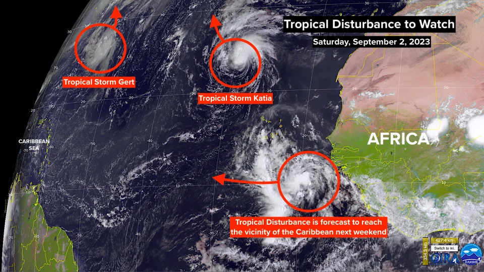
The disturbance has lots of runway to organize into a mature tropical storm or hurricane on its track to the general vicinity of the northeastern Caribbean islands next week. On the current schedule, the system would reach the islands or the waters north of them about next Saturday.
It’s far too early to speculate whether potential-Lee will impact the islands or the U.S. The final track will likely be dependent on how strong the system gets and on what timetable, which can’t be known except in a general sense. The disturbance is expected to organize and intensify, but whether that happens early or late in the week is an open question.
For now, this is just a system to watch, especially later next week.
Elsewhere in the Atlantic, Ex-Idalia is producing tropical-storm-force winds over 50 mph on Bermuda. The system is skirting by to the south and east. Conditions on the island will improve later today.
Tropical Storms Gert and Katia are expected to be short-lived, dying over the open ocean.
Otherwise, more systems over Africa will follow today’s Tropical Disturbance off the continent, but nothing is imminent that is of interest.
No comments:
Post a Comment