It’s possible that I shall make an ass of myself. But in that case one can always get out of it with a little dialectic. I have, of course, so worded my proposition as to be right either way (K.Marx, Letter to F.Engels on the Indian Mutiny)
Tuesday, May 12, 2020
Are more head impacts during NFL career associated with increased risk of death?
JAMA NETWORK OPEN
What The Study Did: Nearly 14,000 current and former National Football League (NFL) players were included in an observational study that examined whether a greater amount of repeated head impacts throughout a professional football career were associated with increased risk of death.
Authors: Brittany L. Kmush, Ph.D., of Syracuse University in Syracuse, New York, is the corresponding author.
Editor's Note: The article includes funding/support disclosures. Please see the article for additional information, including other authors, author contributions and affiliations, conflicts of interest and financial disclosures, and funding and support.
Media advisory: The full study is linked to this news release.
Embed this link to provide your readers free access to the full-text article
About JAMA Network Open: JAMA Network Open is the new online-only open access general medical journal from the JAMA Network. On weekdays, the journal publishes peer-reviewed clinical research and commentary in more than 40 medical and health subject areas. Every article is free online from the day of publication.
A tale of two kinds of volcanoes
UNIVERSITY OF JOHANNESBURG
IMAGE: WHY A BIG VOLCANIC BLOW-UP AT THE POPULAR TRAVEL DESTIMATION SANTORINI 3200 YEARS AGO, BUT JUST A FEW HUNDRED KILOMETERS AWAY, NO DRAMA AT THE VOLCANOES ON AEGINA , METHANA... view more
CREDIT: MS THERESE VAN WYK, UNIVERSITY OF JOHANNESBURG
At an idyllic island in the Mediterranean Sea, ocean covers up the site of a vast volcanic explosion from 3200 years ago. A few hundred kilometers north-west, three other islands still have their volcanic histories from a few million years ago mostly intact. No explosions there. So why the differences between the Santorini caldera and the Aegina, Methana and Poros lava domes? Researchers used volcanic "fingerprints' and plate tectonics research to find out why.
The end of a civilisation
A big volcano blew up about 3200 years ago, right next to where Santorini island is in Greece today. During that eruption, liquid molten rock under the ground (magma) built up immense pressure, and then erupted into a lava explosion. The impact was so intense that the volcano collapsed into a huge basin called a caldera.
What had been an island-volcano, was then overrun by ocean, an event considered partially responsible for the demise of the Minoan civilisation.
Santorini Island became a popular travel destination with big ocean-going ships sailing over the caldera. The village of Phira perches on the cliff-edge of the remains of the volcano.
As idyllic as it looks, the Santorini volcano underneath the ocean still constitutes the biggest volcanic hazard for Europe, together with the Vesuvius volcano in Italy.
Toothpaste rather than fireworks
A few hundred kilometers north-west of Santorini, in Greece's Saronic gulf much closer to Athens, a completely different kind of "volcano" looks much less dramatic.
The small islands of Aegina, Methana and Poros sport rounded hills with roads winding uphill in hairpin bends. These hills have volcanic ancestry too - but they are nothing like Santorini.
Here, liquid lava didn't explode in a big eruption.
"There is no evidence that that large dramatic events ever took place at these islands," says Prof Marlina A. Elburg, a Geology researcher at the University of Johannesburg.
"Thick blocky lava oozed out of magma chambers under the ground at these islands between 5.3 to 2.6 million years ago, during the Pliocene. The lava was so thick, it was more like toothpaste or putty than liquid. It formed lava domes rather than lava volcanoes.
"After a few million years' worth of weathering, they're well camouflaged hills, but they are still considered volcanically active," she says.
How is it possible that volcanoes so close in geological time and space can behave to differently? The researchers used several techniques to find out.
Why a big volcanic blow-up at the popular travel destimation Santorini 3200 years ago, but just a few hundred kilometers away, no drama at the volcanoes on Aegina , Methana and Poros islands? Thin sections of the lavas from these four volcanoes yield some of the reasons why. Some minerals only form at greater depths - and the hornblende in the lava from Aegina island indicates that the magma chambers there are deeper than the those underneath the Santorini caldera. But plate tectonics add another, hidden reason also, found research from the University of Johannesburg.
Finding volcanic 'fingerprints'
Elburg and co-author Ingrid Smet, a PhD candidate at the time, analysed samples of the lavas in new whole rock analyses, in research published in Lithos.
The study followed on their previous research on the lavas at Methana, also published in Lithos.
They looked for the ratios of very specific elements in the samples, called isotope signatures. Isotope signatures work similar to 'fingerprints' for lavas - they help researchers figure out what the lavas were made of, where, and when they were formed.
"Mostly the isotope signatures matched what one would expect from where the islands are located in the Aegean volcanic arc," says Elburg.
But there were surprises too.
Subterranean recycling machine
Underneath all these volcanoes at Aegina, Methana, Poros and Santorini, something else is going on in deep inside the crust of planet Earth. Running roughly east to west underneath the Mediterranean Sea is the Aegean volcanic arc. This arc is where the African tectonic plate 'dives under' the Aegean microplate.
The 'diving under' process is called subduction by geologists. It means that one part of the cool outer crust of Earth starts moving underneath another part of the crust, getting 'recycled' inside the hot liquid rock of the Earth's mantle.
The islands of Aegina, Methana, Poros and Santorini are not just islands with volcanoes. All of them are an integral part of Earth's 'recycling machine' that keeps renewing the crust underneath the planet's oceans.
This raises the question: Why do these islands have such different 'lava histories', even though all of them are on the edge of the Aegean plate?
Some of the answers have to do with what goes into the lava "mixes" for the volcanoes.
Why a big volcanic blow-up at the popular travel destimation Santorini 3200 years ago, but just a few hundred kilometers away, no drama at the volcanoes on Aegina , Methana and Poros islands? At Santorini, the explosion was so intense, the volcano collapsed into a caldera and filled up with ocean. But the other islands have had no such drama. How can volcanoes so close in geological time and space behave so differently? Research from the University of Johannesburg uses lava 'fingerprints' and more to find out why.
Variable lava mix recipes
The African plate 'dives under' the Aegean plate in an oceanic trench in the Mediterranean Sea. This happens very slowly at a few centimeters per year. Which means the pristine cold basalt of the down-going African plate's crust has been soaking in ocean water for millions of years before it enters the much warmer magma underneath the over-riding Aegean plate.
"The crust of the down-going plate now consists of altered rocks, containing minerals with water in them. These minerals become unstable during subduction because of the increasing pressure and temperature, and release their water," says Elburg.
"This water lowers the melting point of the mantle, similar to what happens when adding salt to ice. That is why the mantle under the over-riding starts to melt. It is this molten material, or magma, that flows/oozes out of volcanoes/lava domes as lava."
Another possible ingredient of the differing lavas is sediments in the oceanic trench at the subduction zone. At the Aegean Arc the down-going plate is covered by a very thick pile of ocean sediments. Some of the sediment is former continental crust.
A lot of this sediment is 'scraped off' when the plate subducts and forms an accretionary (or build-up) wedge. However, some of it is also going down into the mantle and getting mixed with the melting mantle wedge, she says.
Same plate, different lavas
Since Aegina, Methana, Poros and Santorini volcanoes are all part of the same subduction zone, the different volcanic activity raises several big questions. One of these is:
Why the thick blocky lava at the western volcanic centres Aegina, Methana and Poros 2.5 to 2 million years ago, but liquid lava at Santorini 3200 years ago?
The answers to this creates other questions about the recycling behaviour of the planet we live on.
But subduction zones are tricky to study. It's not possible to go to one of those and come back with some sample materials. Scientists still need more understanding of what role the overriding plate plays; how much interaction there is between ascending magmas and the crust they ascend through; and whether subduction-related magmas obtain their geochemical signature from the sediment that is recycled back into the earth, says Elburg.
"The answers to these questions can help us understand to what extent the melting processes that started at more than 100 kilometers deep in the mantle, continue when the magma is closer to the surface of the earth," she says.
"This process of 'crustal contamination' is yet another 'Earth recycling machine', which may also influence the potential for ore deposits - like in the Andes, where major copper deposits are found, and where this 'intracrustal recycling' is thought to play an important role".
Deeper vs shallower
One way of studying lavas is to put thin slices (called thin sections) under a microscope and identify the minerals. Because minerals need different conditions to form, their presence can say a lot about where and how magmas were mixed.
In this study the minerals indicated that Santorini lavas were more liquid because they formed at inside shallower magma chambers, while the western volcanic centre lavas were thicker and more blocky because they formed in deeper magma chambers.
"The thin sections of the Santorini lavas display pyroxenes and significant plagioclase. This indicates that the magma from which the crystals formed was located at shallow depths in the earth," says Elburg.
And there is an invisible reason the magma was at shallower depths at Santorini.
"The tectonic plate above Santorini's magma chambers is being pulled apart. In geology terms, it is under localised extension. And because the plate is being stretched out and Santorini is in the middle of it, Santorini happens to be at the thinnest part of the plate.
"With a magma chamber at a shallower depth, the roof will cave in when the chamber starts emptying itself during an eruption. This makes the eruption even worse and creates a caldera, as at Santorini," she adds.
No explosions
In contrast, when they looked at the thin sections of the thick blocky lavas from Aegina and Methana, they found hornblende. The mineral was absent in the Santorini lavas.
Hornblende can only form if the magma is deep enough in the Earth. This indicates that the magma chambers on Aegina and Methana should be located deeper than on Santorini.
"With the magma chambers at greater depths for the western Aegina- Methana-Poros volcanoes, that makes for changes in the lava. There the magma chambers underneath the lava domes did not cave in. Additionally, the crystallization of the amphibole mineral group that includes hornblende, makes magma more viscous, or sticky. So it is more difficult for the magma to come to the surface in the first place.
Over-riding plate vs sediment
To figure out whether the over-riding plate or the ocean sediments were the bigger factor in creating thick blocky lavas, the researchers analysed specific 'lava fingerprints'. These radiogenic isotope ratios gave them the best indication on which materials were mixed into the underground magmas for those lavas.
"We compared Santorini with Aegina-Poros-Methana lavas in terms of their geochemistry on 87Sr/86Sr, 143Nd/144Nd and 208Pb/204Pb. They were distinctly different. Then by combining the radiogenic isotope signature of the lavas with trace element ratios, we managed to pinpoint the down-going sediment as the biggest influence creating thick blocky lavas, not the overriding plate.
No one lava size
"We found that Aegina and Methana-Poros have their own individual volcanic histories, even though they're part of the Aegean arc.
"This means that a simple one-size-fits-all explanation, based on crustal contamination history, for the difference in eruptive style compared to Santorini does not work.
"Modern subduction zones are not all alike. Even in one volcanic arc, more than one eruptive style points to differences in subduction processes," concludes Elburg.
###
INTERVIEWS: For email interviews or questions, contact Prof Elburg at @uj.ac.za.
For interviews via mobile phone / Skype / Zoom with Prof Elburg, contact Ms Therese van Wyk at Theresevw@uj.ac.za or +27 71 139 8407 (mobile) in Johannesburg, UTC + 2.
The research was funded by FWO grants G.0585.06N, G.0669.06 and 1509007N., and TransNational Access project 079-TNA3 of Europlanet.
Chemical evidence of dairying by hunter-gatherers in Lesotho in the first millennium AD
UNIVERSITY OF BRISTOL
IMAGE: VIEW FROM JUST NORTH OF LIKOAENG (SITE LOCATION INDICATED WITH AN ARROW), LOOKING DOWNSTREAM ALONG THE SENQU RIVER. THE LINE OF CLIFFS RUNNING MIDWAY THROUGH THE PHOTO FROM THE LEFT... view more
CREDIT: PETER J. MITCHELL
After analysing organic residues from ancient pots, a team of scientists led by the University of Bristol has uncovered new evidence of dairying by hunter-gatherers in the landlocked South African country of Lesotho in the mid-late first millennium AD.
The study on organic residue analysis from South African hunter-gatherer pots is being published today in Nature Human Behaviour. Extensive archaeological evidence shows that Early Iron Age agricultural communities settled in the coastal regions of KwaZulu-Natal in South Africa from around AD 400.
Although these farmers appear to have been in contact with local lowland hunter-gatherer groups, it was long assumed that they had little or no direct contact with hunter-gatherers already occupying the mountainous regions of Lesotho, as they did not settle the region until the 19th century due to the unsuitability of the mountains for crop cultivation.
Over the past several decades however, remains of domestic animal bones have been uncovered in several sites in the Maloti-Drakensberg Mountains in Lesotho in hunter-gatherer contexts dating to the 1st and 2nd millennia AD.
At one site in particular - Likoaeng - domestic animal bones were found in association with an Early Iron Age potsherd and some fragments of iron. This discovery led to the suggestion that the hunter-gatherers occupying the site were following a 'hunters-with-sheep' mode of subsistence that incorporated the keeping of small numbers of livestock into what was otherwise a foraging economy and that they must have obtained these animals and objects through on-going contact with agricultural groups based on the coast.
In the past five years however, several studies have sequenced DNA from supposed domestic animal bones from these highland sites, and instead found them to belong to wild species. This led to the suggestion that the presence of domestic animals in the highlands, and therefore the level of contact, had been overestimated, yet the zooarchaeologists involved stand by their original morphological assessment of the bones.
Lead researcher, Helen Fewlass, now based at the Max Planck Institute for Evolutionary Anthropology (Leipzig) but who carried out the work as part of her master's project in the University of Bristol's Department of Anthropology and Archaeology, said: "We used organic residue analysis to investigate fats that become absorbed into the porous clay matrix of a pot during its use.
"We extracted and analysed lipid residues from pots from two hunter-gatherer sites with domestic livestock remains in the highlands of Lesotho, Likoaeng and Sehonghong, dating to the mid-late first millennium AD and compared them to lipids extracted from pots from a recent nearby agricultural settlement, Mokatlapoli.
"This allowed us to explore the subsistence practices of the hunter-gatherers occupying these sites to see if there was any evidence for their contact with farming groups."
The team found that dairy residues were present in approximately a third of the hunter-gatherer pots. They directly radiocarbon dated a dairy residue from Likoaeng to AD 579-654 and another from Sehonghong to AD 885-990. The results confirm the presence of domestic animals at these sites in the 1st millennium AD.
The team also observed patterning in the stable carbon isotopic values of fatty acids in the residues, which imply that different methods of animal husbandry were practised by the 1st millennium hunter-gatherer groups compared to the recent agricultural group occupying the same region.
The stable carbon isotopic values of dairy residues from the agricultural site clearly reflect the introduction of crops such as maize and sorghum into the region in the late nineteenth century and the foddering of domestic animals upon them.
As the hunter-gatherer groups must have learnt animal husbandry techniques, the results support the notion that hunter-gatherer groups in the highlands of Lesotho had on-going contact with farming communities in the lowlands, rather than just obtaining the animals through raids or long-distance exchange networks. Based on the direct date of the dairy residue from Likoaeng, contact must have been established within a few centuries of the arrival of agricultural groups in the coastal regions of South Africa.
The results also have implications for the on-going debate about the molecular vs morphological assessment of the faunal remains. The results of the organic residue analysis support the osteoarchaeological evidence for the presence of domestic animals at Likoaeng and Sehonghong. However, as large amounts of milk can be generated from one domestic animal, the prevalence of dairy residues does not tell us how many domestic animals were present.
Direct radiocarbon dating of domestic faunal remains in these contexts has been hampered by poor collagen preservation. The new method (published earlier this month in Nature) for direct dating of fats extracted from potsherds represents a new avenue for placing the arrival and presence of domestic animals in the area in a secure chronological context.
Helen Fewlass added: "The presence of dairy fats in pots from Likoaeng and Sehonghong in highland Lesotho shows that hunter-gatherers in the mountains had adopted at least sporadic use of livestock from agricultural groups in South Africa not long after their arrival in the 1st millennium AD."
Co-author, Dr Emmanuelle Casanova, from the University of Bristol's Organic Geochemistry Unit - part of the School of Chemistry, added: "In addition to the identification of dairying practices we were able apply a brand-new dating method for pottery vessels to verify the antiquity of the dairy residues which perfectly fits with the age of the hunter-gatherer groups."
This study represents the first analysis and direct radiocarbon dating of organic residues from pottery from south-eastern Africa. The high level of preservation found implies that the method has great potential for further applications in the region. This mountainous area of Lesotho has other hunter-gatherer sites containing pottery in contexts dating to the 1st and 2nd millennium AD so there is potential to expand this type of analysis to other sites in the region to understand whether this practise was relatively isolated or ubiquitous.
###
New research determines our species created earliest modern artifacts in Europe
Innovative tools and pendants previously thought to be possibly the work of Neanderthals
NEW YORK UNIVERSITY
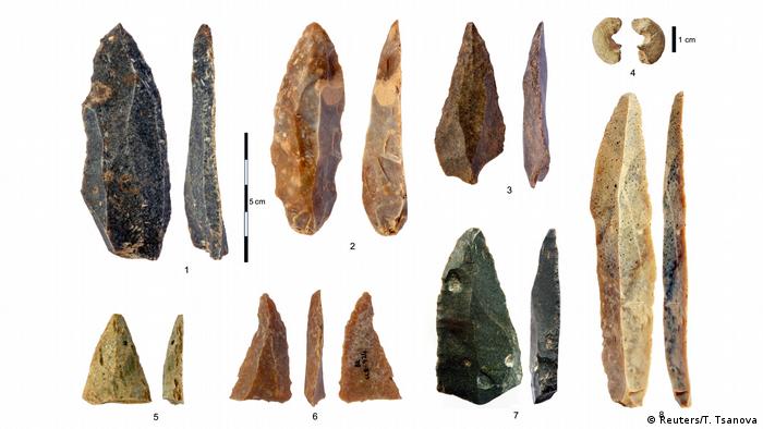
IMAGE: STONE ARTIFACTS FROM THE INITIAL UPPER PALEOLITHIC AT BACHO KIRO CAVE. 1-3, 5-7: POINTED BLADES AND FRAGMENTS FROM LAYER I; 4: SANDSTONE BEAD WITH MORPHOLOGY SIMILAR TO BONE BEADS; 8:... view more
Blade-like tools and animal tooth pendants previously discovered in Europe, and once thought to possibly be the work of Neanderthals, are in fact the creation of Homo sapiens, or modern humans, who emigrated from Africa, finds a new analysis by an international team of researchers.
Its conclusions, reported in the journal Nature, add new clarity to the arrival of Homo sapiens into Europe and to their interactions with the continent's indigenous and declining Neanderthal population.
The analysis centers on an earlier discovery of bones and other artifacts found in the Bacho Kiro cave in what is modern-day Bulgaria.
"Our findings link the expansion of what were then advanced technologies, such as blade tools and pendants made from teeth and bone, with the spread of Homo sapiens more than 45,000 years ago," explains Shara Bailey, a professor in NYU's Department of Anthropology and one of the paper's co-authors. "This confirms that Homo sapiens were mostly responsible for these 'modern' creations and that similarities between these and other sites in which Neanderthals made similar things are due to interaction between the populations."
The findings offer a new understanding of both the nature of these species and their interactions.
"If Neanderthals had created these 'modern' tools and jewelry, it would have indicated they had more advanced cognitive abilities than previously recognized," explains Bailey. "Nonetheless, there are some similarities in manufacturing techniques used by Homo sapiens at Bacho Kiro and Neanderthals elsewhere, which makes clear that there was cultural transmission going on between the two groups."
The analysis was led by researchers at the Max Planck Institute for Evolutionary Anthropology in Leipzig, Germany.
The team, which included scientists from Europe, the United States, and the United Kingdom, focused on the transition from the Middle to Upper Palaeolithic period, between 50,000 and 30,000 years ago. During this time, the European continent experienced the replacement and partial absorption of local Neanderthals by Homo sapiens populations from Africa. However, this process, anthropologists say, likely varied across regions, and the details of this transition remain largely unknown.
To better comprehend a piece of this transition, the team focused on one of several places--Bacho Kiro--where discoveries of the earliest modern technologies, such as pendants and blades, have been made.
To ascertain which species occupied the area of these discoveries, the scientists deployed several methodologies. Bailey, an expert in tooth analysis, and her colleagues examined teeth and bones that had been found in Bacho Kiro.
Using state-of-the-art technology called ZooMS (collagen peptide mass fingerprinting), they identified human bone fragments and concluded that they were at least 45,000 years old--a period coinciding with the arrival of multiple waves of Homo sapiens into Europe. Subsequent shape analyses of the tooth and DNA examination of the fragments determined that they belonged to Homo sapiens and not Neanderthals, whose presence was not evident among the discovered fossils.
"ZooMS allows us to identify previously unidentifiable bone fragments as some form of human," explains Bailey. "From there, we can apply more sophisticated techniques to identify the species and more accurately date human bones."
The oldest Upper Paleolithic Homo sapiens in Europe
Major cultural transition in Europe took place earlier than previously thought
MAX PLANCK INSTITUTE FOR EVOLUTIONARY ANTHROPOLOGY
IMAGE: STONE ARTIFACTS FROM THE INITIAL UPPER PALEOLITHIC AT BACHO KIRO CAVE: 1-3, 5-7 POINTED BLADES AND FRAGMENTS FROM LAYER I; 4 SANDSTONE BEAD WITH MORPHOLOGY SIMILAR TO BONE BEADS; 8... view more
CREDIT: TSENKA TSANOVA, LICENSE: CC-BY-SA 2.0
Two studies report new Homo sapiens fossils from the site of Bacho Kiro Cave in Bulgaria. "The Bacho Kiro Cave site provides evidence for the first dispersal of H. sapiens across the mid-latitudes of Eurasia. Pioneer groups brought new behaviours into Europe and interacted with local Neanderthals. This early wave largely predates that which led to their final extinction in western Europe 8,000 years later", says Jean-Jacques Hublin, director at the Max Planck Institute for Evolutionary Anthropology in Leipzig, Germany.
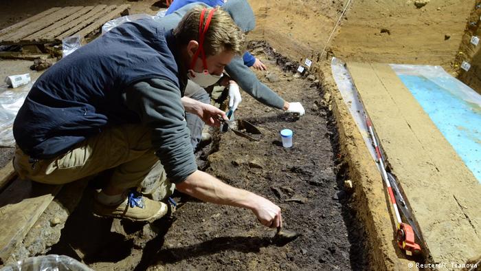
An international research team, led by Jean-Jacques Hublin, Tsenka Tsanova and Shannon McPherron of the Max Planck Institute for Evolutionary Anthropology, and Nikolay Sirakov and Svoboda Sirakova of the National Institute of Archaeology with Museum at the Bulgarian Academy of Sciences in Sofia, Bulgaria, renewed excavations at Bacho Kiro Cave in 2015. The most spectacular finds come from a rich, dark layer near the base of the deposits. Here the team uncovered thousands of animal bones, stone and bone tools, beads and pendants and the remains of five human fossils.
Protein analysis
Except for one human tooth, the human fossils were too fragmented to be recognized by their appearance. Instead, they were identified by analysing their protein sequences. "Most Pleistocene bones are so fragmented that by eye, one cannot tell which species of animal they represent. However, the proteins differ slightly in their amino acid sequence from species to species. By using protein mass spectrometry, we can therefore quickly identify those bone specimens that represent otherwise unrecognizable human bones", says Frido Welker, Postdoctoral Research Fellow at the University of Copenhagen and research associate at the Max Planck Institute for Evolutionary Anthropology.
To know the age of these fossils and the deposits at Bacho Kiro Cave, the team worked closely with Lukas Wacker at ETH Zurich, Switzerland, using an accelerator mass spectrometer to produce ages with higher precision than normal and to directly date the human bones.
"The majority of animal bones we dated from this distinctive, dark layer have signs of human impacts on the bone surfaces, such as butchery marks, which, along with the direct dates of human bones, provides us with a really clear chronological picture of when Homo sapiens first occupied this cave, in the interval from 45,820 to 43,650 years ago, and potentially as early as 46,940 years ago", says Helen Fewlass of the Max Planck Institute for Evolutionary Anthropology. "The radiocarbon dates at Bacho Kiro Cave are not only the largest dataset of a single Palaeolithic site ever made by a research team, but also are the most precise in terms of error ranges", say researchers Sahra Talamo from the University of Bologna and Bernd Kromer from the Max Planck Institute in Leipzig.
DNA sequencing
Though some researchers have suggested that Homo sapiens may have already occasionally entered Europe by this time, finds of this age are typically attributed to Neanderthals. To know which group of humans were present at Bacho Kiro Cave, Mateja Hajdinjak and Matthias Meyer of the genetics team led by Svante Pääbo at the Department of Evolutionary Genetics at the Max Planck Institute for Evolutionary Anthropology sequenced the DNA from the fragmented fossils bones.
"Given the exceptionally good DNA preservation in the molar and the hominin fragments identified by protein mass spectrometry, we were able to reconstruct full mitochondrial genomes from six out of seven specimens and attribute the recovered mitochondrial DNA sequences from all seven specimens to modern humans. Interestingly, when relating these mtDNAs to those of other ancient and modern humans, the mtDNA sequences from Layer I fall close to the base of three main macrohaplogroups of present-day people living outside of Sub-Saharan Africa. Furthermore, their genetic dates align almost perfectly with those obtained by radiocarbon", says Mateja Hajdinjak, Postdoctoral Fellow at the Francis Crick Institute in London and research associate at the Max Planck Institute for Evolutionary Anthropology.
The results demonstrate that Homo sapiens entered Europe and began impacting Neanderthals by around 45,000 years ago and likely even earlier. They brought into Bacho Kiro Cave high quality flint from sources up to 180 km from the site which they worked into tools like pointed blades perhaps to hunt and very likely to butcher the remains of the animals found at the site.
"The animal remains from the site illustrate a mix of cold and warm adapted species, with bison and red deer most frequent", says palaeontologist Rosen Spasov from the New Bulgarian University. These were butchered extensively but were also used as a raw material source. "The most remarkable aspect of the faunal assemblage is the extensive collection of bone tools and personal ornaments", says zooarchaeologist Geoff Smith from the Max Planck Institute for Evolutionary Anthropology. Cave bear teeth were made into pendants, some of which are strikingly similar to ornaments later made by Neanderthals in western Europe.
Excavations in Initial Upper Paleolithic Layer I at Bacho Kiro Cave (Bulgaria). Four Homo sapiens bones were recovered from this layer along with a rich stone tool assemblage, animal bones, bone tools, and pendants.
Homo sapiens replaced Neanderthals
Taken together, the Bacho Kiro Cave sediments document the period of time in Europe when Middle Paleolithic Neanderthals were replaced by Upper Paleolithic Homo sapiens (the so-called transition period), and the first Homo sapiens assemblages are what archaeologists call the Initial Upper Paleolithic. "Up to now, the Aurignacian was thought of as the start of the Upper Paleolithic in Europe, but the Initial Upper Paleolithic of Bacho Kiro Cave adds to other sites in western Eurasia where there is an even older presence of Homo sapiens", notes Nikolay Sirakov of the National Institute of Archaeology with Museum at the Bulgarian Academy of Sciences.
"The Initial Upper Paleolithic in Bacho Kiro Cave is the earliest known Upper Palaeolithic in Europe. It represents a new way of making stone tools and new sets of behaviour including manufacturing personal ornaments that are a departure from what we know of Neanderthals up to this time", says Tsenka Tsanova of the Department of Human Evolution at the Max Planck Institute for Evolutionary Anthropology. "The Initial Upper Paleolithic probably has its origin in southwest Asia and soon after can be found from Bacho Kiro Cave in Bulgaria to sites in Mongolia as Homo sapiens rapidly dispersed across Eurasia and encountered, influenced, and eventually replaced existing archaic populations of Neanderthals and Denisovans."
###
Original publications:
Jean-Jacques Hublin et al.
Initial Upper Palaeolithic Homo sapiens from Bacho Kiro Cave, Bulgaria Nature, 11 May 2020, DOI: 10.1038/s41586-020-2259-z
Helen Fewlass et al.
A 14C chronology for the Middle to Upper Palaeolithic transition at Bacho Kiro Cave, Bulgaria
Nature Ecology and Evolution, 11 May 2020, DOI: 10.1038/s41559-020-1136-3
Bulgarian fossils suggest Homo sapiens arrived in Europe earlier than previously thought
Fossils found in a Bulgarian cave show that Homo sapiens may have swept into Europe 46,000 years ago. This indicates a longer overlap with Neanderthals and suggests major cultural links between the two.
Scientists have found bones in a Bulgarian cave that show modern humans may have arrived in Europe thousands of years earlier than previously thought, at a time when the region had long been home to Neanderthals.
Five fossils, four bone fragments and a tooth, were found in Bulgaria's Bacho Kiro cave, according to two studies published on Monday. Detailed radiocarbon and DNA tests show that the bones anatomically belonged to four Homo sapiens, the oldest dating back some 46,000 years.
An array of artifacts, believed to have been made by the humans, were also found at the site. These include pendants made from the teeth of cave bears, which are about 47,000 years old. The pendants share striking similarities to the ones later made by the Neanderthals in Western Europe, suggesting that they adopted aspects of human culture at the time.
Stone artifacts from Bacho Kiro Cave in Bulgaria of pointed blades and fragments
Researchers believe our species came from Africa during a brief warming period. Europe was then a bastion for Neanderthals, who had inhabited the continent for thousands of years.
Humans and Neanderthals shared the continent for about 7,000 years, said paleoanthropologist Jean-Jacques Hublin, director of the Department of Human Evolution at the Max Planck Institute for Evolutionary Anthropology in Germany.
"The DNA evidence is now secure that Neanderthals and Homo sapiens interacted when they came into contact with one another. In some places those interactions may have even been 'friendly,' for lack of a better word," said New York University anthropologist and study co-author Shara Bailey. "We carry their DNA and they were influenced by our cultural innovations."
The cause of Neanderthals' extinction is a matter of much debate. One of the possibilities is that our species wiped them out after thousands of years of interaction, including interbreeding which left an indelible mark on the human genome.
"In my view, Neanderthals disappeared from Europe because of the competition with our species. However, this did not occur overnight," said Hublin, the lead author of one of the two studies.
IMAGE: AN EXAMPLE OF BOREAL PEATLANDS AND FOREST IN CANADA'S NORTHWEST TERRITORIES. view more
CREDIT: MANUEL HELBIG, MCMASTER UNIVERSITY
HAMILTON, ON, May 11, 2020 - A group of 59 international scientists, led by researchers at Canada's McMaster University, has uncovered new information about the distinct effects of climate change on boreal forests and peatlands, which threaten to worsen wildfires and accelerate global warming.
Manuel Helbig and Mike Waddington from McMaster's School of Geography and Earth Sciences gathered observational data from collaborators in countries across the boreal biome. Their study of how ecosystems lose water to the atmosphere appears today in the journal Nature Climate Change.
The unprecedented detail of their work has highlighted dramatic differences in the ways forests and peatlands regulate water loss to the atmosphere in a warming climate, and how those differences could in turn accelerate the pace of warming.
Most current global climate models assume the biome is all forest, an omission that could seriously compromise their projections, Helbig says.
"We need to account for the specific behavior of peatlands if we want to understand the boreal climate, precipitation, water availability and the whole carbon cycle," he says.
"Peatlands are so important for storing carbon, and they are so vulnerable."
Until now, Helbig says, it had not been possible to capture such a comprehensive view of these water-cycle dynamics, but with the support of the Global Water Futures Initiative and participation from so many research partners in Canada, Russia, the US, Germany and Scandinavia, new understanding is emerging.
As the climate warms, air gets drier and can take up more water. In response to the drying of the air, forest ecosystems - which make up most of the world's natural boreal regions - retain more water. Their trees, shrubs and grasses are vascular plants that typically take up carbon dioxide and release water and oxygen through microscopic pores in their leaves. In warmer, dryer weather, though, those pores close, slowing the exchange to conserve water.
Together with lakes, the spongy bogs and fens called peatlands make up the remainder of the boreal landscape. Peatlands store vast amounts of water and carbon in layers of living and dead moss. They serve as natural firebreaks between sections of forest, as long as they remain wet.
Peatland mosses are not vascular plants, so as warming continues, they are more prone to drying out. Unlike forests, they have no active mechanism to protect themselves from losing water to the atmosphere. Dehydration exposes their dense carbon stores to accelerated decomposition, and turns them from firebreaks into fire propagators, as shown in previous research from Waddington's ecohydrology lab.
Drier peatlands mean bigger, more intense fires that can release vast amounts of carbon into the atmosphere, accelerating global warming, Helbig says.
"It's crucial to consider the accelerated water loss of peatlands in a warming climate as we project what will happen to the boreal landscape in the next 100 to 200 years," he says.
###
New technique uses radar to gauge methane release from Arctic lakes
UNIVERSITY OF ALASKA FAIRBANKS
IMAGE: METHANE EBULLITION BUBBLES FORM IN EARLY WINTER LAKE ICE IN INTERIOR ALASKA. A YARDSTICK IS INCLUDED FOR SCALE. view more
CREDIT: MELANIE ENGRAM PHOTO
A University of Alaska Fairbanks-led research team has developed a way to use satellite images to determine the amount of methane being released from northern lakes, a technique that could help climate change modelers better account for this potent greenhouse gas.
By using synthetic aperture radar, or SAR, researchers were able to find a correlation between "brighter" satellite images of frozen lakes and the amount of methane they produce. Comparing those SAR images with ground-level methane measurements confirmed that the satellite readings were consistent with on-site data.
SAR data, which were provided by UAF's Alaska Satellite Facility, are well-suited to the Arctic. The technology can penetrate dry snow, and doesn't require daylight or cloud-free conditions. SAR is also good at imaging frozen lakes, particularly ones filled with bubbles that often form in ice when methane is present.
"We found that backscatter is brighter when there are more bubbles trapped in the lake ice," said Melanie Engram, the lead author of the study and a researcher at UAF's Water and Environmental Research Center. "Bubbles form an insulated blanket, so ice beneath them grows more slowly, causing a warped surface which reflects the radar signal back to the satellite."
The new technique could have significant implications for climate change predictions. Methane is about 30 times more powerful than carbon dioxide as a heat-trapping gas, so accurate estimates about its prevalence are particularly important in scientific models.
Previous research had confirmed that vast amounts of methane are being released from thermokarst lakes as the permafrost beneath them thaws. But collecting on-site data from those lakes is often expensive and logistically challenging. Because of that, information about methane production is available from only a tiny percentage of Arctic lakes.
"This new technique is a major breakthrough for understanding the Arctic methane budget," said UAF researcher Katey Walter Anthony, who also contributed to the study. "It helps to resolve a longstanding discrepancy between estimates of Arctic methane emissions from atmospheric measurements and data upscaled from a small number of individual lakes."
To confirm the SAR data, researchers compared satellite images with field measurements from 48 lakes in five geographic areas in Alaska. By extrapolating those results, researchers can now estimate the methane production of more than 5,000 Alaska lakes.
"It's important to know how much methane comes out of these lakes and whether the level is increasing," Engram said. "We can't get out to every single lake and do field work, but we can extrapolate field measurements using SAR remote sensing to get these regional estimates."
###
The study was published May 11 in the journal Nature Climate Change. UAF researcher Franz Meyer also contributed to the paper, along with Torsten Sachs, Katrin Kohnert and Andrei Serafimovich from the GFZ German Research Centre for Geosciences, and Guido Grosse from the Alfred Wegener Institute Helmholtz Centre for Polar and Marine Research.
Flying foxes in South Australia exposed to zoonotic viruses
University of Adelaide researchers have found that South Australia's population of Grey-headed flying foxes, which took up residence in 2010, has been exposed to a number of viruses, including Hendra virus that can be transmitted to humans via horses. But they have not found evidence of exposure to Australian bat lyssavirus.
The research, published today in PLOS ONE, details three years of research into the local flying fox population and their exposure to paramyxoviruses (Hendra, Cedar and Tioman) and a rhabdovirus (Australian bat lyssavirus).
Hendra virus and Australian bat lyssavirus are classified as zoonotic viruses. Hendra virus for example can be transmitted to horses and then to humans by airborne droplets causing acute respiratory diseases and death. In the case of Australian bat lyssavirus, humans and other animals need to be bitten or scratched by a carrier. The risks posed by Hendra virus are extremely low with only seven cases in humans, all of whom had been in contact with infected horses, never directly from bats.
Dr Wayne Boardman from the University of Adelaide's School of Animal and Veterinary Sciences says given the Grey-headed flying foxes are known carriers of viruses, they wanted to understand if the local population of flying foxes had been exposed to them.
"Grey-headed flying foxes are essential ecosystem service providers contributing to large-scale pollination and seed dispersal and are a nationally threatened species," Dr Boardman said.
"They have this extraordinary ability to be infected with viruses but don't show any ill effects, except for one virus; the Australian bat lyssavirus. It's important to understand what risks they pose to humans.
"We have found the local population has developed antibodies for the Hendra, Cedar and Tioman viruses, meaning they have been exposed at some stage in their lives.
"What's good news for South Australia is that the local population has not shown exposure to Australian bat lyssavirus, which in humans causes serious illness including paralysis, delirium, convulsions and death.
"It's positive to discover that the risk of lyssavirus transmission in South Australia is lower than anticipated.
"However, this doesn't mean that flying foxes are safe to touch; only people with experience in handling these animals should ever come into contact with them."
The Grey-headed flying fox has made the Botanic Gardens in Adelaide home for the past 10 years, having come to South Australia from New South Wales and Victoria in search of a suitable climate and food.
The research on the local population has also revealed that Hendra virus levels were significantly higher in pregnant females; results that align with findings interstate. However, good body condition is a risk factor for a bigger proportion of the population being exposed to Hendra virus because the flying foxes are in better condition in winter than summer, which is the opposite of what has been found in the eastern states.
Dr Boardman said this means the flying foxes are finding plenty to eat here in winter time specifically, enjoying the introduced foods that are planted in gardens, along roads and in parklands, similar to the normal food source for those in the eastern states.
"The Grey-headed flying fox is certainly enjoying the local environment during the South Australian winter, but we have seen on numerous occasions that the heat in summer certainly knocks the population around so we are looking at ideas to help support them during heatwaves in summer using high level misters and sprinklers."
###
The research was carried out in partnership with CSIRO's Animal Health Laboratory in Geelong, South Australian Museum and Zoos South Australia.