Showing posts sorted by date for query MH370. Sort by relevance Show all posts

Sunday, May 26, 2024

Singapore Airlines turbulence: why climate change is making flights rougher

Warming temperatures are likely to mean that more of your plane ride will have rocky conditions, creating potentially dangerous situations.

By Carissa Wong
NEWS EXPLAINER
22 May 2024

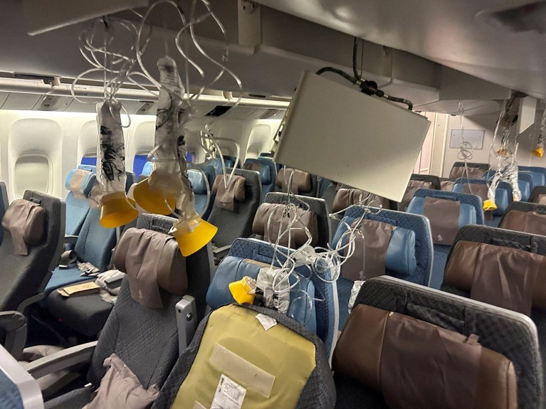
Emergency masks were deployed during the Singapore Airlines flight that experienced severe turbulence this week, killing one man.Credit: Reuters

Severe turbulence on a Singapore Airlines flight from London to Singapore has left a 73-year-old man dead and injured more than 70 people. The incident, although rare, is raising questions about what caused such a serious disruption to the flight — and whether climate change will make the strength and frequency of turbulence on planes worse.

The plane, which departed on 20 May, experienced a sudden drop of around more than 1,800 metres that launched people and objects towards the cabin roof. It is the airline’s first fatal incident in 24 years.

“Severe turbulence is the one that turns you into a projectile,” says atmospheric researcher Paul Williams at Reading University, UK. “For anyone not wearing a seatbelt it would have been a bit like being on a rollercoaster without any restraint in place — it would have been terrifying,” he says.

Nature looks at the science of air turbulence and how climate change will influence it.

What causes turbulence in aeroplanes?

Most flights experience some level of turbulence. Near the ground, strong winds around the airport can cause turbulence as planes take off or land. At higher altitudes, up- and downwards flows of air in storm clouds can cause mild to severe turbulence as planes fly through or near them. “Nobody likes flying through a storm,” says Williams.

Air flows that move upwards over mountain ranges can also create turbulence. “As the air blows over the mountain, the plane gets lifted up and can become turbulent,” says Williams. Moreover, turbulence often occurs on the edges of jet streams, which are strong air currents that circle the globe. Any turbulence that occurs outside of clouds is called “clear air” turbulence. It could take weeks to establish what kind of turbulence caused the Singapore Airlines incident, says Williams. “Provisionally, there was a storm nearby, but also the conditions were right for clear air turbulence — we need to do some more digging before we can say,” he says.

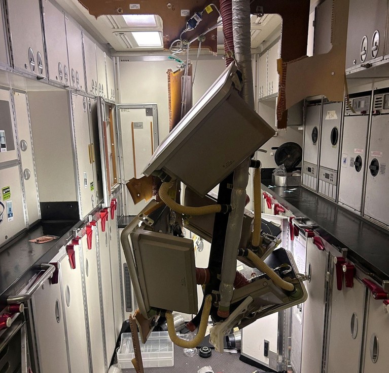
Damage in the galley of the Singapore Airlines Boeing 777 aeroplane.Credit: Reuters

Is climate change making turbulence worse and more frequent?

Climate change is making turbulence more frequent and severe, says atmospheric researcher Jung-Hoon Kim at Seoul National University.

In a study published last year1, Williams and his colleagues found large increases in clear-air turbulence between 1979 and 2020. Over the North Atlantic, severe clear-air turbulence — which is stronger than Earth’s gravity — became 55% more frequent. There were similar increases in turbulence all over the world, he says. The increase is almost certainly the result of climate change, which is strengthening the jet streams that cause turbulence, says Williams. “We already know it’s having an impact,” he says.

In another study2, Williams and his colleagues used a climate model to predict that clear-air turbulence would become more severe and frequent as the climate warms. The researchers estimated that severe turbulence would increase in frequency more than light or moderate levels of turbulence. In line with this, Kim and his colleagues found that clear-air turbulence around clouds and mountains would become more frequent with climate change, in a study published last year.

Despite the probable rise in turbulence, most flights will carry on as they do now — with light or mild turbulence, says Williams. “It is not that we’ll have to stop flying, or planes will start falling out of the sky,” says Williams. “I’m just saying that for every 10 minutes, you’ve spent in severe turbulence in the past, it could be 20 or 30 minutes in the future,” says Williams.

Can we predict and prevent bad turbulence?

Pilots use turbulence projections to plan flight paths. Researchers at weather centres can predict turbulence based on data collected from ground-based sensors and satellites and communicate predictions to pilots. On the plane, pilots use radar to identify storm clouds to avoid. This relies on radiowaves being sent out from the aircraft, which are then reflected back towards sensors that map out the surrounding area.

But radar cannot detect cloudless clear air turbulence. Another technology called LiDAR could help, says Williams. “LiDAR is similar to radar but uses a different wavelength of light,” says Williams, “Unfortunately it’s expensive, and requires a big heavy box, but it can see invisible clear air turbulence.” If the box can be miniaturised and the cost comes down, it could soon be used, he says. “I’ve seen some experimental flights, and you can indeed see clear air turbulence 20 miles, for example, ahead of the aircraft,” he says.

Until then, “I hope that everybody when they travel, please fasten your seat belts,” says Kim.

doi: https://doi.org/10.1038/d41586-024-01542-2

References

  1. Prosser, M. C., Williams, P. D., Marlton, G. J. & Harrison, R. G. Geophys. Res. Lett. 50, e2023GL103814 (2023).

    Article Google Scholar 

  2. Storer, L. N., Williams, P. D. & Joshi, M. M. Geophys. Res. Lett44, 9976–9984 (2017).

    Article Google Scholar 

Download references

Monday, April 01, 2024


Ocean Mapping is the Next Front in Battle for Influence in Indian Ocean

China is now offering itself as an alternative provider of hydrographic services to many countries.

Chinese research ship

PUBLISHED MAR 31, 2024 4:23 PM BY THE LOWY INTERPRETER


[By David Brewster]

Hydrography, the mapping of bodies of water and surrounding coastal details, is the new front in the battle for influence in the Indian Ocean. There is growing competition among India, China and others to chart international waters as well as the exclusive economic zones of countries around the region. Smaller nations are pushing back, wanting to build their own sovereign capabilities and control over information about their maritime domain. Australia can play a useful role in finding ways to build local capabilities and ameliorate this new source of strategic competition.

More than just crucial for the safely at sea of commercial and private boats and ships, hydrographic data is also essential for naval operations, including surface vessels and submarines, as well as emerging commercial activities such as seabed mining.

It’s said that humanity knows more about the surface of the Moon than the ocean floor. This is particularly the case in the Indian Ocean, which is among the least charted oceans in the world. During the search for the missing Malaysian Airlines MH370 in 2014 it became evident that we had little idea of what the ocean floor looked like. Indeed, many countries in the region still often use colonial-era charts from the 19th century.

Hydrography is now assuming a geopolitical focus with major powers competing to provide hydrographic services to countries with few capabilities or little expertise in this area. This is used to demonstrate regional leadership and, more importantly, gain access to data vital for military purposes such as submarine operations. Underlying this are important issues of sovereignty. Who should own or control information about the sea, particularly in areas of national jurisdiction?

India has long sought to position itself as a regional provider of hydrographic services. It has a fleet of about seven hydrographic vessels and has conducted approximately 100 foreign hydrographic surveys, including in Maldives, Mauritius, Kenya, Tanzania, Myanmar, Sri Lanka and Seychelles just in the last few years. India also builds local capabilities, including training for around 800 foreign nationals from countries throughout the Indian Ocean, Asia and Africa.

Accepting hydrographic assistance makes a lot of sense for many countries in the region that may have large exclusive economic zones with little idea of what is down there. But what was once considered to be uncontroversial is now much more fraught.

China is now offering itself as an alternative provider of hydrographic services to many countries. Chinese agencies operate more than 30 oceanographic surveillance and research vessels, many of which also have electronic surveillance capabilities.

But while Chinese offers of assistance can be tempting for many, letting them map areas of national jurisdiction has become highly controversial. India, in particular, has significant concerns about China’s research activities in the Indian Ocean, particularly near the Bay of Bengal where India’s nuclear submarine fleet is based.

These issues have come to a head in Sri Lanka. The presence of Chinese research vessels in Sri Lankan waters, most recently the Shi Yan 6 in October 2023, drew loud protests from New Delhi. Shortly after, Sri Lanka announced an effective 12-month moratorium on research by all foreign research vessels while it worked out what to do about the issue. The Sri Lankan government later moved to cancel an agreement between a Chinese institute and a local university under which China gained easy access to Sri Lanka’s waters, and its hydrographic data. The government also created a new agency under the Ministry of Defence to supervise hydrographic research.

Controversy was reignited after a German research vessel was allowed to dock in Colombo for replenishment last week.

Hydrographic information is not only a security issue but also an economic one. Through regaining control over its hydrographic data, the Sri Lankan government hopes to make considerable profits from providing electronic charts to the hundreds of ships that pass Sri Lankan waters every day. To achieve this, Sri Lanka needs to develop its sovereign hydrographic capabilities. The United States and Australia are considering what assistance can be provided.

Similar controversies are unfolding in nearby Maldives, an island state with a tiny population but a huge maritime jurisdiction. In December last year, the newly elected Maldives government announced that it would not renew an agreement with India under which India was undertaking hydrographic surveys of Maldives waters. This has created a vacuum in Maldives hydrographic needs.

In February, the Chinese research vessel Xiang Yang Hong 03 docked in Maldives’ capital after undertaking three weeks of hydrographic surveys just outside the exclusive economic zones of Maldives, Sri Lanka and India. (From the location of the survey it’s probable that its main purpose was for future People's Liberation Army Navy submarine and anti-submarine operations.) Days later, Maldives signed a defence cooperation agreement with China. Its terms haven’t been disclosed but is understood to involve the supply of riot control equipment. Following this agreement, Beijing is pushing hard to expand its security role in the country, which, among other things, will be to allow Chinese vessels to map Maldives waters and possibly even establish a marine research station in the country’s north.

United States, Britain and Australia are now scrambling to find ways to help build Maldives’ sovereign national hydrographic capabilities. Maldives may be well advised to follow Sri Lanka’s example by declaring a moratorium on visits by all foreign research vessels to give it time to build a level of national capabilities to the extent possible. In time, Maldives may also need to find ways of bringing in outside assistance in a way that mitigates sovereignty concerns, for example, through working with coalitions of international partners.

These developments in Sri Lanka and the Maldives are the first steps in what is likely to become a wider regional struggle over ownership and control of critical hydrographic information.  

Dr. David Brewster is with the National Security College at the Australian National University, where he specializes in South Asian and Indian Ocean strategic affairs. He is also a Distinguished Research Fellow with the Australia India Institute. 

This article appears courtesy of The Lowy Interpreter and may be found in its original form here

The opinions expressed herein are the author's and not necessarily those of The Maritime Executive.

Sunday, March 31, 2024

WATER SPOUT LISBON PORTUGAL 

MARCH 30, 2024 


MY THEORY OF WHAT TOOK DOWN FLIGHT MH370

Tuesday, March 12, 2024


Flight MH370's Disappearance Shows the Difficulty of Deep-Sea Search

MH370 search area
A 2014 search plan shows the rugged contours of the Indian Ocean seabed (Australian Transportation Safety Bureau)

PUBLISHED MAR 11, 2024 8:42 PM BY THE CONVERSATION


[By Jamie Pringle, Alastair Ruffell Reader and Ruth Morgan]

It has been ten years since Malaysian Airlines Flight MH370, carrying 239 passengers and crew on board, disappeared less than one hour after taking off from Kuala Lumpur on 8 March 2014. It has become one of the great mysteries of modern times and is a puzzle that has remained resolutely unsolved.

Theories abound on the flight’s disappearance and current location of the wreckage. Unusually, all communications aboard the plane were switched off shortly after take-off.

Intermittent satellite location information subsequently suggested it was flown south on a very different flight path than expected, to a remote and deep ocean area of the Southern Indian Ocean before contact was lost.

When actively searching for MH370, sophisticated international surveillance aircraft initially conducted over 300 flights to visually look for plane debris on the surface. Then surface and submersible vehicles conducted further surveys, searching over 120,000 square kilometers of ocean before ending the search in 2017.

The effort to find MH370 became one of the most expensive aviation searches in history. These surveys used both sonar (active acoustic instruments to image the sea floor to locate the aircraft), and also listening devices to pick up the aircraft’s flight data recorder.

Confirmed MH370 plane debris was found on Reunion Island in July 2015 and off the coast of Mozambique in February 2016, which was consistent with what we know about ocean currents. In 2018, OceanInfinity, a private exploration company, also searched 25,000 square kilometers, but without success.

Since then, a mixture of highly trained experts and members of the public have sought to assist the search. These efforts have varied from simple to really advanced data analysis. They have attempted to map the locations and timings of plane debris, and other maritime debris, as well as model drift currents. In doing so, they are attempting to reconstruct where these may have originated from, which is no small task.

Analysis of the MH370 flight path has been pieced together from two different types of radar – primary and secondary – as well as the intermittent data “pings” from the plane to the Inmarsat satellite. The results suggest that it diverted south from its intended flight path.

Another technique called weak signal propagation (WSPR data (a way of using radio emission to track objects such as planes), had defined a specific but very large search area, some of which has already been searched.

Available hydroacoustic data (based on the way sound propagates in water) of the sea floor has also been analyzed. However, only a relatively small area was covered and the marine sea floor in this region can be very rugged. There are deep submarine canyons that can hide objects much bigger than a plane.

Lessons from studying past flight disasters also informed the search. These included the 2009 Yemenia plane crash in the Indian Ocean.

Recovery operation

For inland or coastal water searches, a phased investigation strategy is suggested as best practice, where investigators look to identify water depths, major current strengths and directions, together with pre-existing site information, before specialist search teams are employed using methods, equipment configurations and personnel that have all been accredited.

However this reliance on technology can be problematic. Even in small waterways, the presence of vegetation in the search area or a target buried by sediment can make these searches difficult.

Much of the Southern Indian Ocean sea floor is rugged and relatively unmapped, with water depths of up to 7,400 meters. It’s away from regular shipping lanes and commercial flight patterns, with few fishing boats, no significant land masses and some of the worst winds and weather in the world. These factors also make it a very challenging area to search.

In deep water (more than 2-3,000 meters) deploying sonar is cumbersome and prohibitively expensive. It also takes a long time to generate data. A major challenge for scanning technologies is achieving accuracy at these kinds of depths due to the scattering of the signal caused by uneven, especially rocky substrates on the sea floor.

The development of more advanced autonomous submersible vehicles may hold the key to finding MH370 in the Southern Indian Ocean, along with post-processing of raw data which can clarify what can be attributed to rocks as well as sea-floor hummocks and pockets.

This can distinguish between the sea floor and the objects being searched for. However, the area where MH370 disappeared is vast, meaning future searches will remain just as challenging as when the plane first went missing in 2014.

Jamie Pringle is a Reader in Forensic Geoscience at Keele University.

Alastair Ruffell is a Reader at the School of Natural and Built Environment, Queen's University Belfast.

Ruth Morgan is Vice Dean Engineering and Professor of Crime and Forensic Science at UCL.

This article appears courtesy of The Conversation and may be found in its original form here.

The Conversation

The opinions expressed herein are the author's and not necessarily those of The Maritime Executive.


MH370

MY THEORY: WATERSPOUT 


Sunday, March 03, 2024

Mystery of missing Malaysia MH370 flight: Fresh hope kindles as govt plans to renew search

It has been 10 years since the flight's disappearance

Web Desk Updated: March 03, 2024 
Families of passengers from both China and Malaysia, who were aboard the missing Malaysia Airlines flight MH370, are seen during a remembrance event commemorating the 10th anniversary of its disappearance, in Subang Jaya, Malaysia 

Ten years after the disappearance of the Malaysia Airlines MH370 flight, the government on Sunday said it has plans to renew the search after a US technology firm proposed a fresh hunt in the southern Indian Ocean, where the plane is believed to have crashed.

While speaking at a remembrance event to mark the 10th anniversary of the disappearance of the flight, Transport Minister Anthony Loke said the government is keen to locate MH370.

Texas-based Ocean Infinity has proposed another no find, no fee basis to scor the seabeds as an expansion from where it first searched in 2018.

He said he invited the company to meet and evaluate the new scientific evidence.

"If it is credible, will seek Cabinet's approval to sign a new contract with Ocean Infinity," he added.

The Boeing 777 plane carrying 239 people from Kuala Lumpur to Beijing vanished from radar shortly after taking off on March 8, 2014.

Since then all the searches by the government failed to unravel the mystery behind its disappearance.

Ocean Infinity-led searches before had found no clues, however, its proposed new search plan was delayed last year.

The government is yet to finalise the deal as the fee negotiation is not yet over. He said financial cost is not an issue and that he doesn't foresee any hindrances for the search to proceed if all goes well.

The announcement of the renewed search has sparked hope in at least some family members. "We have been on a roller coaster for the last 10 years... If it is not found, I hope that it will continue with another search," Jacquita Gomes, whose flight attendant husband was on the plane, was quoted by the Associated Press.

She also added that it will pave for a full closure.

Family members of passengers from Malaysia, Australia, China and India paid tribute to their loved ones during the event, lighting a candle on stage to remember them.


MY THEORY 


Sunday, January 28, 2024

Ocean exploration company believes it may have found Amelia Earhart's wrecked plane: 'We're all hopeful'

Andrea Vacchiano
Sun, January 28, 2024 


A South Carolina-based ocean exploration company says it may have found the airplane that Amelia Earhart flew on her ill-fated 1937 expedition.

Deep Sea Vision CEO Tony Romeo said he believes that the airplane-shaped object that his company captured in a sonar image is Earhart’s Lockheed 10-E Electra.

Earhart was trying to become the first woman to successfully complete a circumnavigational flight of the globe when she disappeared on July 2, 1937. She was last seen in Papua New Guinea and disappeared near Howland Island in the Pacific Ocean.


ON THIS DAY IN HISTORY, JANUARY 11, 1935, AMELIA EARHART IS FIRST AVIATOR TO FLY SOLO, HAWAII TO CALIFORNIA

The aviator was declared dead in absentia on Jan. 5, 1939.

"We think it could be her plane," Romeo told local outlet The Post and Courier.

"[But] I’m not saying we definitely found her."

National Air and Space Museum curator Dorothy Cochrane told the Wall Street Journal that the location where the pictures were taken is "about right."

RARE AMELIA EARHART FOOTAGE SURFACES IN TEXAS

"It was one of the great mysteries of the 20th century and still now into the 21st century," Cochrane said.

"We’re all hopeful that the mystery will be solved."


The image of the object was taken in the Pacific Ocean.

In an interview with the WSJ, Romeo said he plans to return to get clearer pictures of the unknown object.

"This is maybe the most exciting thing I’ll ever do in my life," he said. "I feel like a 10-year-old going on a treasure hunt."

AMELIA EARHART: WHAT TO KNOW ABOUT THE AVIATION PIONEER

Earhart's disappearance has perplexed Americans for decades. Ocean exploration firm Nauticos launched three expeditions to find her plane between 2002 and 2017, and came up with nothing.

Romeo, whose company used a $9 million drone to search 6,000 miles of the Pacific, said he is "optimistic" about the sonar image.

"It’s almost a perfect riddle," Romeo said to the Post and Courier.

"There’s just enough information to pull you in. [And] just enough bits of information that aren’t there to draw you in even more."


The CEO of Deep Sea Vision says he plans to return to get clearer pictures of the unknown object.

Fox News Digital reached out to Deep Sea Vision for comment.

A former US Air Force officer spent $11 million searching for Amelia Earhart's long-lost plane — and may have found it

Katherine Tangalakis-Lippert,Rebecca Rommen
Sat, January 27, 2024 at 9:58 PM MST·7 min read

A former US Air Force officer spent $11 million searching for Amelia Earhart's long-lost plane — and may have found it


Amelia Earhart seated atop the cockpit of the twin-motored, all-metal, Lockheed-Elecktra monoplane, is pictured adjacent to a sonar image of what researchers believe may be the wreckage of her ill-fated flight.Getty Images/Deep Sea Vision

Tony Romeo believes he's discovered Amelia Earhart's long-lost aircraft.


Romeo told BI he captured an image of an aircraft-shaped object on the floor of the Pacific Ocean.


Experts say the location seems roughly correct but clearer images are needed.

A pilot and former US Air Force intelligence officer believes an image he captured using sonar on a high-tech unmanned submersible may have finally answered one of America's most baffling mysteries: What caused the disappearance of iconic pilot Amelia Earhart at the height of her fame?

Tony Romeo is one of a long line of researchers and hobbyists to have taken up the search for Earhart's distinctive Lockheed 10-E Electra plane, which disappeared over the Pacific Ocean along with its famous pilot and navigator Fred Noonan during an attempt to circumnavigate the globe in July of 1937.


Amelia Earhart, 40, stands next to a Lockheed Electra 10E, before her last flight in 1937 from Oakland, California.AP Photo

The mystery surrounding Earhart's disappearance has long puzzled researchers and spurred conspiracy theories over the years, from the Japanese taking her prisoner to her being a government spy.


But Romeo, a former real estate investor who sold commercial properties to raise the $11 million needed to begin funding the search, returned in December from a roughly 100-day voyage at sea with a sonar image that he believes shows the lost plane in the ocean's depths.
A high-tech search at sea

His expedition, which was carried out using a $9 million high-tech unmanned submersible "Hugin" drone manufactured by the Norwegian company Kongsberg, and a research crew of 16, started last September in Tarawa, Kiribati, covering 5,200 square miles of the ocean floor, The Wall Street Journal reported.

It was a dream Romeo had for years before making it a reality.

"This has been a story that's always intrigued me, and all the things in my life kind of collided at the right moment," Romeo, whose father and brothers are also pilots, told Business Insider. "I was getting out of real estate and looking for a new project so even though I really started about 18 months ago, this was something I've been thinking and researching for a long time."


Amelia Earhart took off from the airport in her £10,000 Flying Laboratory for Honolulu on the first leg of her round-the-world flight.AP Photo

Roughly a month into the trip, the team captured a sonar image of the plane-shaped object about 100 miles from Howland Island — but didn't discover the image in the submersible's data until the 90th day of the voyage, making it impractical to turn back to get a closer look.

Experts have shown interest in the finding, with Dorothy Cochrane, a curator at the Smithsonian Institution's National Air and Space Museum, telling The Journal that the reported location where the image was taken was just about right, geographically, compared to where Earhart's flight is believed to have gone down.


A map of where Earhart's plane is believed to have gone missing along her presumed flight path.Google Maps

But others say they need clearer views and more details, such as the plane's serial number.

"Until you physically take a look at this, there's no way to say for sure what that is," Andrew Pietruszka, an underwater archaeologist at the Scripps Institution of Oceanography, told The Journal.

Romeo, who said the search may be "the most exciting thing I'll ever do in my life," added that he planned to return to the area to try to capture better images using autonomous or robotic submersibles equipped with cameras and sonar to get closer to the object, which rests more than 16,500 feet beneath the surface.

Romeo told BI that if it's not Earhart's plane, the object he found could be a different missing aircraft lost in the Pacific or — less interestingly, perhaps — another manmade object that fell off a shipping container. But as of now, he's feeling confident he's made a groundbreaking discovery due to the distinctive shape of the fuselage, tail, and wings.


Romeo and his company, Deep Sea Vision, discovered an object of similar size and shape to Amelia Earhart's iconic plane, deep in the Pacific Ocean.Deep Sea Vision

"The next step is confirmation — we've gotta go back out with different sorts of sensors and really photograph it well and take a look at how the artifact is sitting on the seabed," Romeo told BI. "Once that step is done, lots of people will be involved. The Smithsonian, the family, there'll be some investors involved because it'll be an expensive operation, but then we're thinking: 'How do we lift the plane? How do we salvage it?'"

He added: "I don't think we're there yet. But I do think Americans want to see this in the Smithsonian; that's where it belongs. Not the bottom of the ocean."
A decadeslong mystery

Hopeful explorers have pumped millions of dollars into expeditions to find Earhart's lost plane over the years, but her last known location has made the searches difficult.

"It's very deep water, and the area that she could've possibly been in is huge," Tom Dettweiler, a sonar expert, told The Journal.

One team who searched for Earhart's aircraft in 2009 said on X, formerly Twitter, that following its 2,500-square-mile search near Howland Island, close to where Romeo conducted his search, it was only "confident" that they knew where the aviator "isn't."


Earhart, who was the first woman to fly solo across the Atlantic and the US, was declared legally dead on January 5, 1939, two years after she vanished. But her legacy has lived on and she continues to fascinate people worldwide.

"It was one of the great mysteries of the 20th century and still now into the 21st century," Cochrane told The Journal. "We're all hopeful that the mystery will be solved."
The dateline theory

Romeo believes he's taken a massive step toward answering vital questions surrounding the famous pilot's disappearance after scouring decades of clues and potential leads to her location, including the "dateline theory."

The theory, which Romeo relied on partly to guide his search, suggests that when Earhart crossed over the international dateline during her 20-hour flight, her navigation system became inaccurate and misdirected her by about 60 miles, potentially leading to a tragic end.

American aviatrix Amelia Earhart is welcomed with a string of leis around her neck shortly after landing in Honolulu, Hawaii, after a speedy flight from Oakland, California, on March 18, 1936. AP Photo

Once he has confirmation that he's found Earhart's plane, hopefully during another voyage planned for later this year, Romeo says the company he has created as part of the search will continue trying to solve other mysteries held in the ocean.

"There's lots of cool stuff in the Pacific — WWII aircraft and flight MH370 are still out there, and maybe we can make a run at that at some point," Romeo told BI. "I'm not announcing yet that we are, but I'd love to collaborate with other folks on other projects since we've got the state-of-the-art equipment. There's only a couple of these in the world and finding these things out is in demand."

Wednesday, December 27, 2023

 11 passengers injured after 'freak' turbulence forces UK-bound jet to be diverted to Bermuda

There's a type of turbulence that can’t be seen by pilots, or easily picked up by 
radar or satellite. It could become more prevalent.

Freak turbulence has left 11 passengers injured on a Manchester-bound flight.

About 225 passengers and 13 crew were on board the Maleth Aero flight on Sunday (Monday NZT) after a P&O Caribbean cruise.

The turbulence occurred around two hours after departure from Barbados, with pilots forced to divert the aircraft to Bermuda.

Upon landing, 11 passengers were treated for minor injuries.

Passengers stayed in hotels in Bermuda

Lack of available flights coupled with reduced operational hours over the festive period meant passengers had to stay in hotels in Bermuda over Christmas, a P&O spokesperson said.


A replacement plane was due to take off at 4pm on Boxing Day (local time) and arrive back in the UK in the early hours of December 27.

A P&O Cruises spokesperson said: “A flight from Barbados to Manchester was diverted to Bermuda following freak turbulence.

Maleth Aero is a Maltese passenger charter airline.

‘Very sorry’ for disruption

“Having explored all flying options and due to airport operating times, guests are in hotels today [Dec 25].

“The flight home is due to depart tomorrow morning [Dec 26], following required legislative aircraft checks.

“We are very sorry for this disruption to their journey following their holiday and we are working with the airline and hotels to take care of them and ensure they get home as soon as possible tomorrow.”

Owen Darrell, Bermuda’s minister of national security, said: “We are aware of the situation and are diligently working to ensure the wellbeing of all involved. We are extremely grateful for the quick response of all our emergency services personnel who ensured the safety of the passengers and crew.”


SEE

LA REVUE GAUCHE - Left Comment: Search results for MH370 

LA REVUE GAUCHE - Left Comment: Search results for WATERSPOUT 

Tuesday, November 28, 2023

Families of Malaysia Airlines plane crash victims call for new search

Relatives of passengers of the missing Malaysia Airlines flight MH370 hold a sign reading "Malaysia Airlines MH370 cases" close to a court building in Beijing 
- Copyright AFP Pedro PARDO


Ludovic EHRET
AFP
November 27, 2023

Relatives of dozens of Chinese passengers who died when a Malaysia Airlines plane disappeared almost 10 years ago called Monday for a new investigation, as a Beijing court began hearing their fresh appeal for compensation.

The MH370 jet vanished on March 8, 2014, carrying 239 people — mostly from China — en route from Kuala Lumpur to Beijing.

More than 40 families have filed lawsuits against Malaysia Airlines, the aircraft manufacturer Boeing, engine maker Rolls Royce and Allianz insurance group, state broadcaster CCTV said.

The families’ litigation requests focus on compensation and finding the truth behind the flight’s disappearance, according to Zhang Qihuai, a lawyer quoted by CCTV.

Hardly any trace of the plane was found in a 120,000-square kilometre (46,000-square mile) Indian Ocean search zone, with only some pieces of debris picked up.

The Australian-led operation, the largest in aviation history, was suspended in January 2017.

The families on Monday released an open letter addressed to Malaysian Prime Minister Anwar Ibrahim, calling for a new search for the missing aircraft on a “No find, No fee” basis.

“Our family members hope to search for flight MH370 on our own,” the letter said, adding “family members are willing to invest their own money or cooperate with capable individuals and companies”.

They asked for “effective communication” with the Malaysian government to kick off a new hunt.

Outside the court, many relatives were on the verge of tears as they recounted stories of their loved ones, some holding pieces of paper saying “restart the search” and “open, fair, impartial”.

Bao Lanfang lost her son, daughter-in-law and granddaughter in the disaster, and her husband died last year.

“Personally, I do not care about the monetary compensation,” the 71-year-old told the media.

“What I want is that Malaysia Airlines gives me the truth. What happened to our loved ones?

“What I want now is for them to resume the search and the investigation.”

Malaysia’s transport ministry and Malaysia Airlines both declined to comment on the hearings.

– ‘Unbearable’-

It is unclear what jurisdiction the Chinese court has to enforce the claims for compensation against the defendants.

Each family filed for civil compensation of between 10 million yuan ($1.4 million) and 80 million yuan ($11.2 million), as well as moral damages of 30 million yuan ($4.2 million) to 40 million yuan ($5.6 million), CCTV reported.

The families of more than 110 other passengers have already reached a settlement with the defendants and received between 2.5 million and 3 million yuan, the broadcaster said.

Gathering outside the court on Monday despite freezing temperatures, relatives were keen to talk to journalists.

Jiang Hui, whose mother was on flight MH370, said the opening of the hearing was “very comforting, and it is a turning point”.

“The survival of the relatives during these 10 years, the deterioration of their living conditions… This really makes us very sad. So I hope that the legal relief can be realised as soon as possible. It is not difficult,” he said.

“Ten years have really been unbearable for us,” added Jiang.

The hearing was not listed on the court’s public website, but Jiang wrote on social media this month the court hearings would continue until mid-December.

– Unsolved mystery –


A US exploration firm launched a private hunt for MH370 in 2018, but it ended after several months of scouring the seabed without success.

The disappearance of the plane has long been the subject of a host of theories — ranging from the credible to outlandish — including that veteran pilot Zaharie Ahmad Shah had gone rogue.

In 2016, Malaysian officials revealed the pilot had plotted a path over the Indian Ocean on a home flight simulator but stressed this did not prove he deliberately crashed the plane.

A final report into the tragedy released in 2018 pointed to failings by air traffic control and said the course of the plane was changed manually.

But they failed to come up with any firm conclusions, leaving relatives angry and disappointed.

IT WAS SUCKED DOWN BY A WATER SPOUT IN THE INDIAN OCEAN


Monday, November 27, 2023


MH370


Beijing court begins hearings for Chinese relatives of people on Malaysia Airlines plane


THE ASSOCIATED PRESS

November 27, 2023 Photo/Illutration

Hu Xiufang, whose son, daughter-in-law and granddaughter were on the missing MH370, hold a banner in Beijing, Nov. 27, 2023. The banner reads 'Malaysian Airline MH370 case.' (AP Photo)

BEIJING--A Beijing court began compensation hearings Monday morning for Chinese relatives of people who died on a Malaysia Airlines plane that disappeared in 2014 on a flight to Beijing, a case that remains shrouded in mystery after almost a decade.

Security was tight around the Chinese capital’s main Chaoyang District Intermediary Court and no detailed information was immediately available. Police checked the identities of journalists onsite and sequestered them in a cordoned-off area. Reporters were able to see relatives enter the court but were unable to speak with them before the hearing began.

Various theories have emerged about the fate of the plane, including mechanical failure, a hijacking attempt or a deliberate effort to scuttle it by those in the cockpit, but scant evidence has been found to show why the plane diverted from its original route from Kuala Lumpur to Beijing. The Boeing 777 with 227 passengers and 12 crew aboard is believed to have plunged into the Southern Ocean south of India but months of intense searching found no sign of where it went down and only fragments of the plane have washed up on beaches in the area.

Among the passengers onboard, 153 or 154 by differing accounts were citizens of China, causing the disaster to resonate especially in Beijing, where daily briefings and vigils were held for those missing. Some relatives refused to believe the plane had disappeared, believing it had been taken to an unknown site and that their loved ones remained alive, and refused a accept relatively small compassionate payments from the airline.

Details of the lawsuit remain cloudy but appear to be based on the contention that the airline failed to take measures to locate the plane after it disappeared from air traffic control about 38 minutes after takeoff over the South China Sea on the night March 8, 2014.

Relatives have been communicating online and say they expect the hearings to extend to mid-December

Given the continuing mystery surrounding the case, it remains unclear what financial obligations the airline may have and no charges have been brought against the flight crew. However, relatives say they wish for some compensation for a disaster that deprived them of their loved ones and placed them in financial difficulty.

China’s largely opaque legal system offers wide latitude for judges to issue legal or financial penalties when criminal penalties cannot be brought.

Similar cases brought in the U.S. against the airline, its holding company and insurer have been dismissed on the basis that such matters should be handled by the Malaysian legal system.

China itself says it is still investigating the cause of the crash of a China Eastern Airlines jetliner that killed 132 people on March 21, 2022. The disaster was a rare failure for a Chinese airline industry that dramatically improved safety following deadly crashes in the 1990s.

The Boeing 737-800 en route from Kunming in the southwest to Guangzhou, near Hong Kong, went into a nosedive from 8,800 meters (29,000 feet), appeared to recover and then slammed into a mountainside.