It’s possible that I shall make an ass of myself. But in that case one can always get out of it with a little dialectic. I have, of course, so worded my proposition as to be right either way (K.Marx, Letter to F.Engels on the Indian Mutiny)
Monday, June 07, 2021
ANOTHER FROZEN LIFE FROM THE PERMAFROST Weird "wheel animals" wriggle back to life after 24,000 years frozen
June 07, 2021
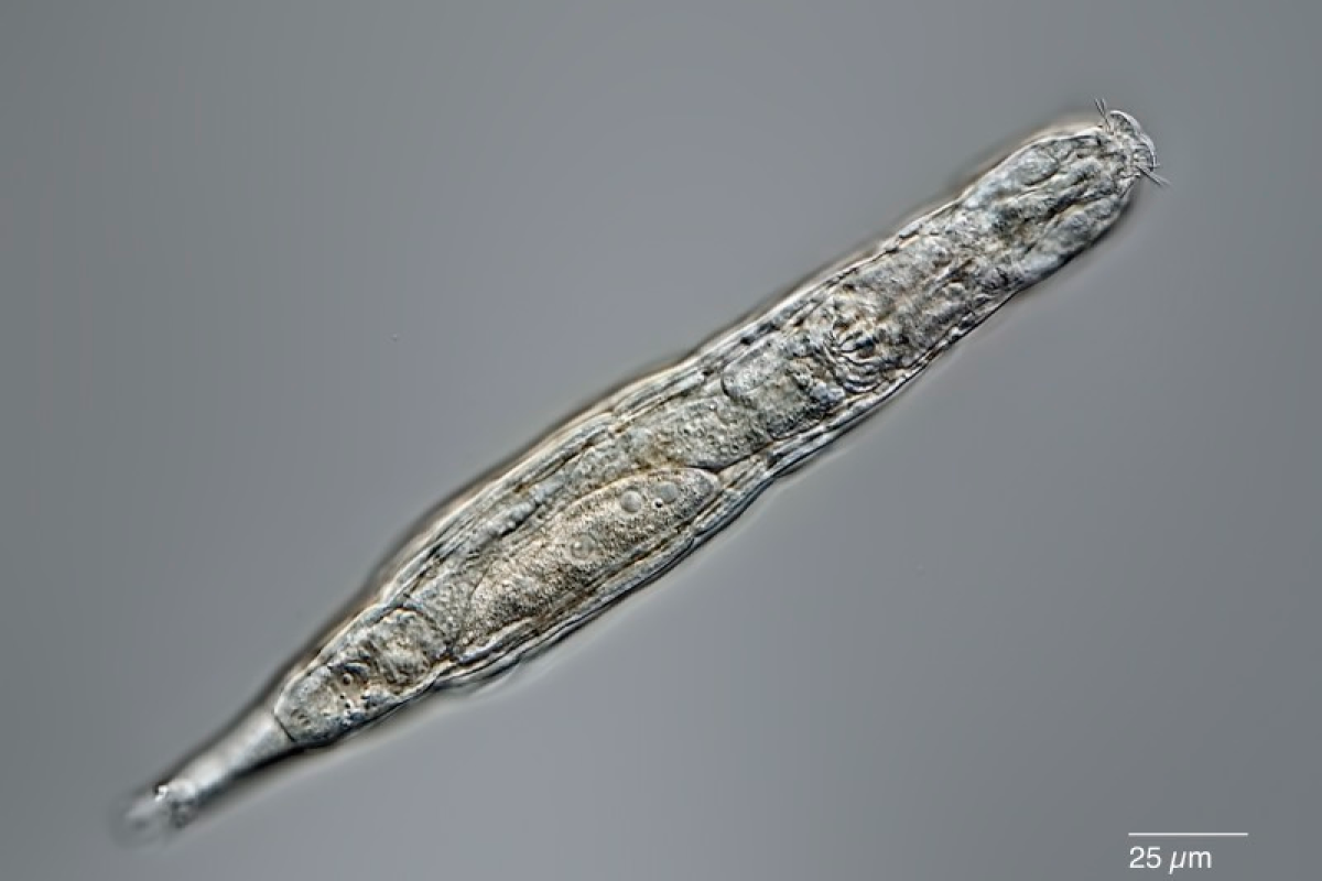
Bdelloid rotifers can survive being frozen for long periods by entering a state called cryptobiosis Michael Plewka
Scientists have managed to revive microscopic animals that had been frozen in the Siberian permafrost for 24,000 years. The Bdelloid rotifers, or “wheel animals” as they’re sometimes called, shook off their long sleep and went right back to moving, eating and reproducing like the Ice Age was only yesterday.
Bdelloid rotifers are tiny tubular creatures that are surprisingly tough. In that way, rotifers are a lot like tardigrades, except that the latter eats the former. When conditions get too cold or dry for them, rotifers will curl up into a ball and dry out, hibernating for months or years until conditions become more favorable again.
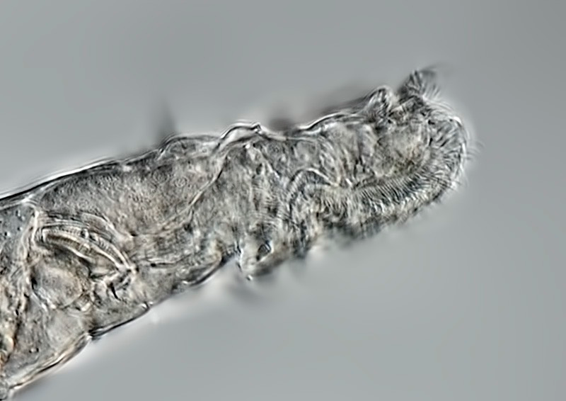
A close up of a bdelloid rotifer Michael Plewka
But now the little critters have absolutely smashed their previous record of about 10 years. In this case, the researchers used radiocarbon dating to determine that the permafrost from which they were recovered was between 23,960 and 24,485 years old. As if that wasn’t impressive enough, the rotifers were still able to reproduce through their usual asexual process, called parthenogenesis.
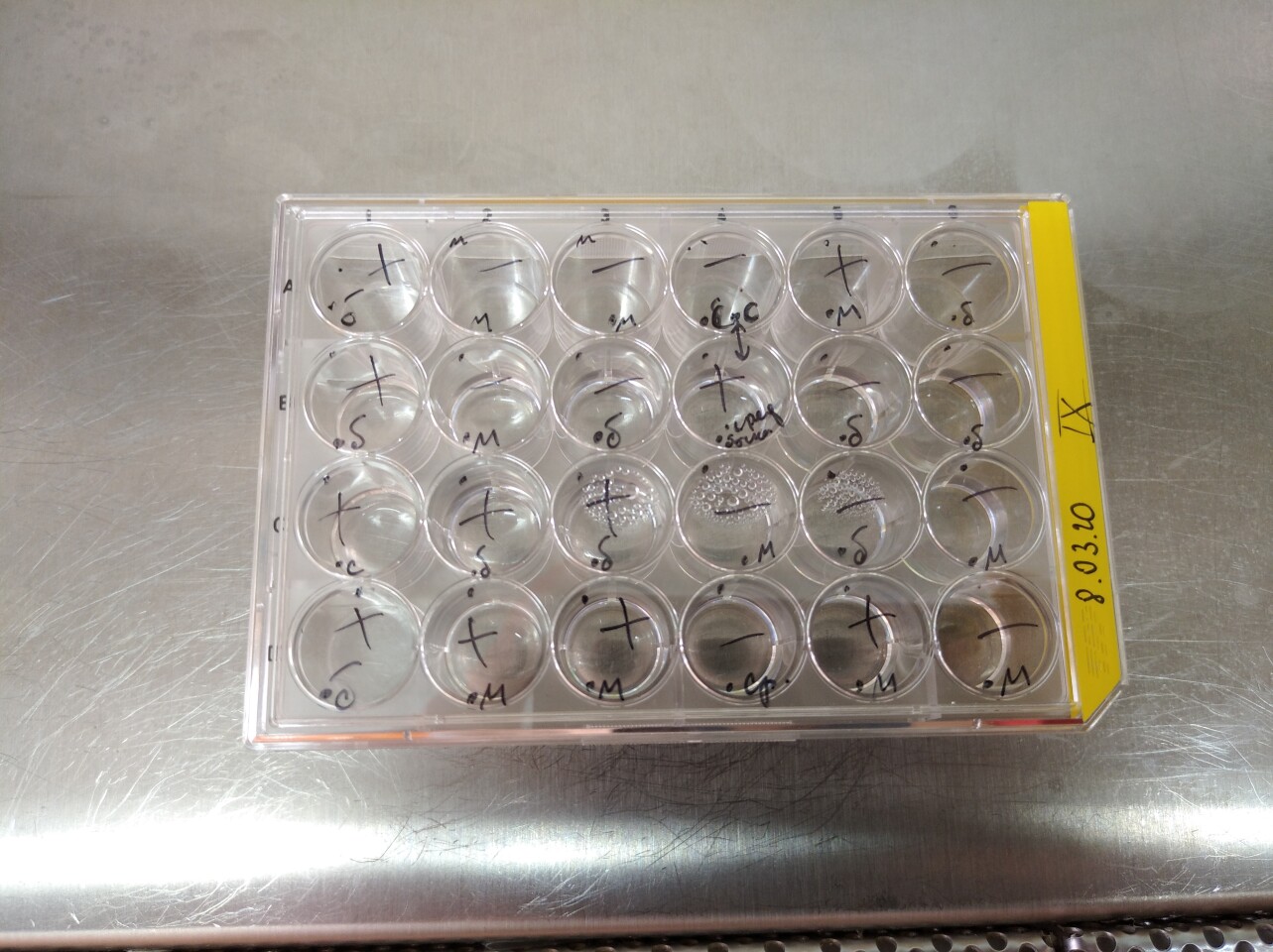
The researchers examined these second generation rotifers more closely, and found that while they were very closely related to modern ones, they’re different enough to constitute a new species. Next, to examine just how the animals might survive such extreme conditions, the researchers froze some of these rotifers at -15 °C (5° F) for one week, then thawed them out and watched them reawaken.
While most multicellular forms of life are damaged by the formation of ice crystals, rotifers seem to be able to protect their cells and organs from this damage. Exactly how remains unknown at this point, the team says. The experimental setup designed to test how the rotifers could withstand being frozen and thawed Stas Malavin
As impressive as a 24,000 year slumber is, these rotifers don’t actually hold the record. Worms called nematodes have wriggled back to life after about 40,000 years, while a batch of bacteria has them both beat at an astonishing 100 million years. Still, rotifers may be the most complex creatures in the club so far.
"The takeaway is that a multicellular organism can be frozen and stored as such for thousands of years and then return back to life – a dream of many fiction writers," says Stas Malavin, an author of the study. "Of course, the more complex the organism, the trickier it is to preserve it alive frozen and, for mammals, it's not currently possible. Yet, moving from a single-celled organism to an organism with a gut and brain, though microscopic, is a big step forward.”
THE RUSSIANS HAVE BEEN DOING CRYOSCIENCE SINCE THE SIXTIES, TRYING TO REVIVE FROZEN LIFE FOUND IN THE PERMAFROST
SPACE RACE 2.5 BILLIONAIRES IN SPACE Jeff Bezos and his brother to be on first Blue Origin passenger flight By David Szondy June 07, 2021 Jeff Bezos and his brother Mark will be passengers on the first Blue Origin human flight Blue Origin
Jeff Bezos has announced that he and his brother Mark will be aboard the first passenger-carrying Blue Origin flight on July 20, joining the winner of the continuing auction for the first paid seat, which now stands at US$2.8 million. If all runs to plan, this means Bezos will beat his fellow billionaires with space ambitions, Elon Musk and Sir Richard Branson, into space courtesy of technology developed by his own company.
Today's announcement signals confidence on the part of the Blue Origin founder regarding the odds of success for the first passenger flight of the Reusable Space Ship First Step crew capsule atop the New Shepard booster, which will lift off next month for a 10-minute suborbital flight into space from the company's Launch Site One in West Texas.
During the mission, the capsule will separate from the booster and coast to an altitude of over 62 miles (100 km), letting the passengers experience weightlessness and see the curvature of the Earth, before returning to the ground by parachute.
The run up to the flight is marked by the auction for the first paying passenger seat, which has attracted almost 6,000 people from 143 countries. Opening bidding will run until June 10 and will continue as a live online auction on June 12 at 1 pm EDT for registered and verified bidders.
If you have a few million dollars going spare, auction details can be found on the Blue Origin site. Proceeds from the auction will go to Blue Origin's Club for the Future, which encourages young people to enter the STEM field.
Jeff Bezos discusses the flight in the video below.
MISSION MORNINGSTAR
NASA selects 2 Venus missions to explore Earth’s ‘hellish’ neighbor
By Eliza Fawcett, Hartford Courant Published: June 7, 2021
For decades, scientists who study Earth’s neighbor Venus have watched with dismay as NASA sends mission after mission to Mars.
The last time the United States visited Venus was in 1989, when it sent the spacecraft Magellan to map the topography of the “hellish” planet. Although Venus is roughly the size of Earth, the planet is fundamentally different, encased in a dense, toxic atmosphere of carbon dioxide. The air pressure on Venus’ surface is equivalent to the pressure experienced a mile beneath Earth’s oceans.
Now, a Wesleyan professor is playing a key role in two newly-announced NASA missions to Venus.
“The question has always been, if you have two Earth-sized planets right next to each other, and one of them is habitable and teeming with life, and the other is not, what happened?” said Dr. Martha S. Gilmore, a professor of earth and environmental sciences at Wesleyan University in Middletown.
At long last, the moment to answer that question has come. Last week, NASA selected two Venus missions, both of which Gilmore helped develop, for its Discovery Program. Each project will receive about $500 million from NASA for development. The missions are expected to launch by 2028 to 2030.
One mission, VERITAS, will send an orbiter to Venus to create high-resolution imaging of the planet’s surface and gather data on the composition of its rocky topography. The other mission, DAVINCI+, will drop an atmospheric probe through Venus’ harsh atmosphere to measure its chemical composition.
“These two sister missions both aim to understand how Venus became an inferno-like world capable of melting lead at the surface,” NASA administrator Bill Nelson said in a speech last week. “They will offer the entire science community the chance to investigate a planet we haven’t been to in more than 30 years.”
NASA’s selection was a thrilling victory for Gilmore and other scientists in the small, insular research community that studies Venus. For years, researchers have submitted proposals to return to the planet, only to see them passed over in favor of other projects. In 2017, both Venus missions were in contention for NASA funding but lost out to two asteroid missions.
It’s different this time around.
“The relief we feel, it’s like, ‘Oh my god, finally!’” Gilmore said.
‘Other Earths’
Gilmore has been enamored of Venus since she was a doctoral student at Brown University, back when the Magellan mission was deployed. Although she has also studied Mars extensively over the course of her career, she has always been drawn to Venus, partly because the planet may hold the key to understanding what she calls “the basic building blocks of planets.”
“As we look out there, we want to find other Earths. We want to look at Earth-sized planets,” Gilmore said. “And so what better way to do that than to study an Earth-sized planet that we have access to, which is Venus?”
ANOTHER SOVIET FIRST
The Soviet space program began exploring Venus in the early 1960s and eventually landed spacecraft on the planet’s surface that took images of its rugged, rocky terrain — before getting crushed under the intense heat and pressure. Magellan spent four years in Venus’ orbit and mapped the planet’s surface, returning images that, at the resolution of a football field, showed that it was covered in ancient lava flows, indicating a history of volcanic activity.
Over the last decade, Gilmore said, scientific research has shown evidence for active volcanism on Venus, and new models have indicated that the planet’s climate may have been habitable for billions of years. The two new missions will provide the most extensive opportunity in years to explore the many unanswered questions about Venus — and our solar system.
For instance: Why do some planets become habitable while others don’t? Where does water come from? Do planets have an initial supply of water, or does it arrive from comets or meteorites?
“The imaging that DAVINCI+ will do and then mapping that VERITAS will do will let us look at landforms. That’s how we identified water on Mars: We can see sedimentary rocks; we can look for river channels and morphology,” Gilmore said.
In addition to obtaining high-resolution images of Venus’ surface, VERITAS (Venus Emissivity, Radio Science, InSAR, Topography, and Spectroscopy), the orbiter, will conduct a spectroscopy to determine the composition of the planet’s rocks, enabling scientists to study how the rocks were formed. Gilmore specializes in studying the oldest rocks on Venus, and her research suggests that those rocks are “compositionally different than the younger lava flows and different in a way that suggests they were formed in the presence of water.”
As it falls toward Venus’s surface, DAVINCI+ (Deep Atmosphere Venus Investigation of Noble gases, Chemistry, and Imaging Plus) will have just 62 minutes to collect data and measure the atmosphere’s chemical composition. The probe is not designed to withstand the impact of landing.
On the DAVINCI+ mission, Gilmore has worked to fit the probe with a camera that will return high-resolution images of “tesserae,” unique geological features on Venus which may be similar to the Earth’s continents.
“As we go down over these old terrains, we can get images of them at the centimeter scale, to understand what those rocks are,” she said. “Are they sediments? Are there channels down there? We don’t know.” Preparing for the launch
The two Venus missions are still seven to nine years away from being launched. In the coming years, Gilmore and other scientists will work with engineers to refine the mission designs. Gilmore is also conducting experiments on rocks that will eventually help her interpret the data the missions generate.
The real work begins once the missions are complete and a fresh trove of data is available for analysis — a task that Gilmore’s undergraduate and graduate students will be able to assist on.
“That’ll probably take me through the rest of my career,” she said.
For now, Gilmore said she’s proud of the work the Venus community has done to get to this point. And she’s eagerly anticipating the work to come.
“I’m still shocked,” she said. “But I’m thrilled.”
NASA eyes return to inhospitable Venus
By MARCIA DUNN, Associated Press Published: June 3, 2021
This image shows the planet Venus made with data from the Magellan spacecraft and Pioneer Venus Orbiter. On Wednesday, NASA administrator Bill Nelson announced two robotic missions to the solar system's hottest planet. (NASA/JPL-Caltech)
CAPE CANAVERAL, Fla. — NASA is returning to sizzling Venus, our closest yet perhaps most overlooked neighbor, after decades of exploring other worlds.
The space agency’s new administrator, Bill Nelson, announced two new robotic missions to the solar system’s hottest planet, during his first major address to employees Wednesday.
“These two sister missions both aim to understand how Venus became an inferno-like world capable of melting lead at the surface,” Nelson said.
One mission named DaVinci Plus will analyze the thick, cloudy Venusian atmosphere in an attempt to determine whether the inferno planet ever had an ocean and was possibly habitable. A small craft will plunge through the atmosphere to measure the gases. It will be the first U.S.-led mission to the Venusian atmosphere since 1978.
The other mission, called Veritas, will seek a geologic history by mapping the rocky planet’s surface.
“It is astounding how little we know about Venus,” but the new missions will give fresh views of the planet’s atmosphere, made up mostly of carbon dioxide, down to the core, NASA scientist Tom Wagner said in a statement.
NASA’s top science official, Thomas Zurbuchen, calls it “a new decade of Venus.” Each mission, launching around 2029, will receive $500 million for development under NASA’s Discovery program.
The missions beat out two other proposed projects, to Jupiter’s moon Io and Neptune’s icy moon Triton.
DISASTER CAPITALI$M
Puerto Rico is prone to more flooding than the island is prepared to handle
CREDIT: PHOTO BY SGT. JOSE AHIRAM DIAZ-RAMOS/PRNG-PAO
AUSTIN, Texas -- Puerto Rico is not ready for another hurricane season, let alone the effects of climate change, according to a new study that shows the island's outstanding capacity to produce record-breaking floods and trigger a large number of landslides.
The latest research, appearing in the journal Hydrology, builds on three prior studies led by hydrologist Carlos Ramos-Scharrón at The University of Texas at Austin, whose team began investigating the devastating impact of tropical cyclones on the island after Hurricane Maria in 2017.
The first compared the 2017 hurricane as a rainstorm event to more than a century of cyclones that came before it, finding that Maria produced the highest island-wide daily rainfall amount ever recorded (similar to Hurricane Harvey's impact on Houston). The second found that Maria's rainfall triggered one of the highest number of rainfall-induced landslides ever reported worldwide in similarly sized areas. And the third identified landslides as the main source of the sediment infilling the already limited water storage capacity of the island's main reservoirs.
"We need to stop talking about climate change in future tense. It's already here," said Ramos-Scharrón, associate professor in the Department of Geography and the Environment and the Teresa Lozano Long Institute of Latin American Studies. "Climate change projections for the Caribbean suggest longer dry periods interrupted by more intense storms. These storms release large quantities of sediment by landslides, and many of those end up reducing the island's capacity to store water. The combined effect of these climate change projections is for a higher propensity for water scarcity."
CAPTION
Civil Air Patrol in cooperation with the Air National Guard does an ariel survey over northern Puerto Rico Sept. 26, 2017 after hurricane Maria impacted the island on Sept. 20, 2017. The Civil Air Patrol is part of the Air Force's total force concept.
CREDIT
US Air Force photo by Airman 1st Class Nicholas Dutton
The latest paper, which focused on streamflow levels, draws attention to another glaring issue -- Puerto Rico is not prepared to handle the severe flooding sure to come its way. Flood management and the design of vital infrastructure, such as bridges, largely rely on a calculation of the likelihood that an event of a given magnitude is going to occur. For a particular region, that calculation depends on the history of flooding.
In Puerto Rico, the most current method to make such calculations relies on data collected only up to 1994. Since then, Hurricanes Hortense (1996), Georges (1998) and Maria surpassed bot100-year and 500-year flood marks across the island, with Maria surpassing 500-year levels in five locations.
h Five other tropical storms matched or surpassed 100- and 500-year levels in some specific locations, particularly near the central-eastern end of Puerto Rico, which is most vulnerable due to the westward trajectory of most tropical cyclones and the island's hilly topography.
"Events with these 100- and 500-year metrics just cannot be that common," Ramos-Scharrón said. "If this is not what climate change is supposed to be, then I do not know what it is. It can creep up on you. Puerto Rico needs to adapt its planning tools to the reality of what the island has experienced and scientists are documenting."
CAPTION
The Adjuntant General of Puerto Rico, Brig. Gen. Isabelo Rivera, and State Command Sgt. Maj. Juvencio Méndez, along with the Governor of Puerto Rico, Hon. Ricardo Rosselló Nevares, and the Resident Commissioner of Puerto Rico in Washington, Hon. Jennifer González, the director of FEMA in Puerto Rico, Alejandro de la Campa, and the Director of the Authority of Electrical Energy of Puerto Rico, Eng. Ricardo Ramos, realized a reconnaissance flight of the island, Sept. 23, with aid from Puerto Rico National Guard Army Aviation, San Juan, P.R.
CREDIT
Sgt. Jose Ahiram Diaz-Ramos/PRNG-PAO
Papers explore massive plankton blooms with very different ecosystem impacts
IMAGE: THE VIDEO PLANKTON RECORDER BEING RECOVERED AFTER A SUCCESSFUL SURVEY. view more
CREDIT: DAN BRINKHUIS, SCIENCEMEDIA.NL
"The big mystery about plankton is what controls its distribution and abundance, and what conditions lead to big plankton blooms," said Dennis McGillicuddy, Senior Scientist and Department Chair in Applied Ocean Physics and Engineering at the Woods Hole Oceanographic Institution (WHOI).
Two new papers explore this question and provide examples of conditions that lead to massive plankton blooms with vastly different potential impacts on the ecosystem, according to McGillicuddy, co-author of both papers. Both papers also point to the importance of using advanced technology--including Video Plankton Recorders, autonomous underwater vehicles, and the Ocean Observatories Initiative's Coastal Pioneer Array--to find and monitor these blooms.
In one paper, Diatom Hotspots Driven by Western Boundary Current Instability, published in Geophysical Research Letters (GRL), scientists found unexpectedly productive subsurface hotspot blooms of diatom phytoplankton.
In the GRL paper, researchers investigated the dynamics controlling primary productivity in a region of the Mid-Atlantic Bight (MAB), one of the world's most productive marine ecosystems. In 2019, they observed unexpected diatom hotspots in the slope region of the bight's euphotic zone, the ocean layer that receives enough light for photosynthesis to occur. Phytoplankton are photosynthetic microorganisms that are the foundation of the aquatic food web.
It was surprising to the researchers that the hotspots occurred in high-salinity water intruding from the Gulf Stream. "While these intrusions of low?nutrient Gulf Stream water have been thought to potentially diminish biological productivity, we present evidence of an unexpectedly productive subsurface diatom bloom resulting from the direct intrusion of a Gulf Stream meander towards the continental shelf," the authors note. They hypothesize that the hotspots were not fueled by Gulf Stream surface water, which is typically low in nutrients and chlorophyll, but rather that the hotspots were fueled by nutrients upwelled into the sunlight zone from deeper Gulf Stream water.
With changing stability of the Gulf Stream, intrusions from the Gulf Stream had become more frequent in recent decades, according to the researchers. "These results suggest that changing large?scale circulation has consequences for regional productivity that are not detectable by satellites by virtue of their occurrence well below the surface," the authors note.
"In this particular case, changing climate has led to an increase in productivity in this particular region, by virtue of a subtle and somewhat unexpected interaction between the physics and biology of the ocean. That same dynamic may not necessarily hold elsewhere in the ocean, and it's quite likely that other areas of the ocean will become less productive over time. That's of great concern," said McGillicuddy. "There are going to be regional differences in the way the ocean responds to climate change. And society needs to be able to intelligently manage from a regional perspective, not just on a global perspective."
The research finding demonstrated "a cool, counterintuitive biological impact of this changing large scale circulation," said the GRL paper's lead author, Hilde Oliver, a postdoctoral scholar in Applied Ocean Physics and Engineering at WHOI. She recalled watching the instrument data come in. With typical summertime values of about 1-1.5 micrograms of chlorophyll per liter of seawater, researchers recorded "unheard of concentrations for chlorophyll in this region in summer," as high as 12 or 13 micrograms per liter, Oliver said.
Oliver, whose Ph.D. focused on modeling, said the cruise helped her to look at phytoplankton blooms from more than a theoretical sense. "To go out into the ocean and see how the physics of the ocean can manifest these blooms in the real world was eye opening to me," she said.
Another paper, A Regional, Early Spring Bloom of Phaeocystis pouchetii on the New England Continental Shelf, published in the Journal of Geophysical Research: Oceans (JGR: Oceans), also was eye opening. Researchers investigating the biological dynamics of the New England continental shelf in 2018 discovered a huge bloom of the haptophyte phytoplankton Phaeocystis pouchetii.
However, unlike the diatom hotspots described in the GRL paper, Phaeocystis is "unpalatable to a lot of different organisms and disrupts the entire food web," said Walker Smith, retired professor at the Virginia Institute of Marine Science William and Mary, who is the lead author on the JGR: Oceans paper. The phytoplankton form gelatinous colonies that are millimeters in diameter.
When Phaeocystis blooms, it utilizes nutrients just like any other form of phytoplankton would. However, unlike the diatoms noted in the GRL paper, Phaeocystis converts biomass into something that doesn't tend to get passed up the rest of the food chain, said McGillicuddy.
"Understanding the physical-biological interactions in the coastal system provides a basis for predicting these blooms of potentially harmful algae and may lead to a better prediction of their impacts on coastal systems," the authors stated.
Massive blooms of the colonial stage of this and similar species have been reported in many systems in different parts of the world, which Smith has studied. These types of blooms probably occur about every three years in the New England continental shelf and probably have a fairly strong impact on New England waters, food webs, and fisheries, said Smith. Coastal managers need to know about these blooms because they can have economic impacts on aquaculture in coastal areas, he said.
"Despite the fact that the Mid-Atlantic Bight has been well-studied and extensively sampled, there are things that are going on that we still don't really appreciate," said Smith. "One example are these Phaeocystis blooms that are deep in the water and that you are never going to see unless you are there because satellites can't show them. So, the more we look, the more we find out."
###
Both of these studies were carried out as part of the National Science Foundation-funded Shelfbreak Productivity Interdisciplinary Research Operation at the Pioneer Array involving partners at WHOI, University of Massachusetts Dartmouth, Massachusetts Division of Marine Fisheries, Virginia Institute of Marine Science, Wellesley College, and Old Dominion University. Additional support has been provided by the Dalio Explorer Fund.
For more information, see the video "Life at the Edge: Plankton Growth at the Shelf Break Front," produced by ScienceMedia.nl for WHOI.
About Woods Hole Oceanographic Institution
The Woods Hole Oceanographic Institution (WHOI) is a private, non-profit organization on Cape Cod, Massachusetts, dedicated to marine research, engineering, and higher education. Established in 1930, its primary mission is to understand the ocean and its interaction with the Earth as a whole, and to communicate an understanding of the ocean's role in the changing global environment. WHOI's pioneering discoveries stem from an ideal combination of science and engineering--one that has made it one of the most trusted and technically advanced leaders in basic and applied ocean research and exploration anywhere. WHOI is known for its multidisciplinary approach, superior ship operations, and unparalleled deep-sea robotics capabilities. We play a leading role in ocean observation and operate the most extensive suite of data-gathering platforms in the world. Top scientists, engineers, and students collaborate on more than 800 concurrent projects worldwide--both above and below the waves--pushing the boundaries of knowledge and possibility. For more information, please visit http://www.whoi.edu
A Regional, Early Spring Bloom of Phaeocystis pouchetii on the New England Continental Shelf
Authors: Walker O. Smith Jr.1,2*, Weifeng G. Zhang3, Andrew Hirzel3, Rachel M. Stanley4, Meredith G. Meyer1, Heidi Sosik3, Philip Alatalo3, Hilde Oliver3, Zoe Sandwith3, E. Taylor Crockford3 , Emily E. Peacock3, Arshia Mehta4 , and Dennis J. McGillicuddy Jr.3
Affiliations:
1 Virginia Institute of Marine Science, William & Mary, Gloucester Pt., VA, USA
2 School of Oceanography, Shanghai Jiao Tong University, Shanghai, China
3 Woods Hole Oceanographic Institution, Woods Hole, MA, USA
4 Department of Chemistry, Wellesley College, Wellesley, MA, USA
*Corresponding author
Diatom Hotspots Driven by Western Boundary Current Instability
Authors: Hilde Oliver1*, Weifeng G. Zhang1, Walker O. Smith, Jr.,2,3, Philip Alatalo1, P. Dreux Chappell4, Andrew Hirzel1, Corday R. Selden4, Heidi M. Sosik1, Rachel H. R. Stanley5, Yifan Zhu4, and Dennis J. McGillicuddy, Jr.1
Affiliations:
1Woods Hole Oceanographic Institution, Woods Hole, MA, USA
2Virginia Institute of Marine Science, College of William & Mary, Gloucester Point, VA, USA
3School of Oceanography, Shanghai Jiao Tong University, Shanghai, People's Republic of China
4Department of Ocean and Earth Sciences, Old Dominion University, Norfolk, VA USA 5Department of Chemistry, Wellesley College, Wellesley, MA, USA *Corresponding autho
Climate warming to increase carbon loss in Canadian peatland by 103 per cent
Carbon loss in Canadian peatland is projected to increase by 103 per cent under a high emission scenario, according to new research led by scientists from the University of Waterloo.
The results of the study, which was published today in Nature's Communications Earth & Environment journal, reinforces the urgent need for a comprehensive understanding of peatlands as evolving sources of atmospheric CO2 in a warming world.
Peatlands, which are a type of wetland, are some of the most valuable ecosystems globally. In addition to their role in preserving biodiversity and minimizing flood risk, they store approximately one-third of the world's terrestrial organic carbon, despite only covering an estimated three per cent of the continents.
The researchers believe the study, which had Faculty of Engineering student Arash Rafat as lead author, has implications for future climate policy. Even under the lowest radiative forcing scenario, peatlands will act as a source of CO2 during the non-growing season (NGS) throughout the remainder of the 21st century. This reinforces the hypothesis that climate warming has the potential to increase peatland CO2 emissions during the NGS across various northern regions from around the world.
"Our research offers important insights into how Canada's northern peatlands will react to climate warming, especially during the non-growing season," said Fereidoun Rezanezhad, a professor in Waterloo's Department of Earth and Environmental Sciences. "As the climate warms, it is important to understand to what degree this will impact peatland ecosystems and their release of CO2 emissions - especially in areas of greatest warming, which include peatlands in northern regions and during the NGS."
To improve our ability to predict NGS CO2 emissions from northern peatlands under current and future climate change, a team of Waterloo's Water Institute researchers led by Ecohydrology Research Group professors Rezanezhad and Philippe Van Cappellen worked with professor William Quinton of Wilfrid Laurier University, professor Elyn Humphreys of Carleton University, and research scientist Dr. Kara Webster from the Canadian Forest Service Great Lakes Forestry Centre.
The team developed a machine-learning model to determine that changes in soil temperature and photosynthesis are the primary drivers of changes in net carbon flux. To predict future NGS CO2 emissions, the team developed the model using a continuous 13-year dataset of eddy covariance flux measurements from a peatland site located in Ottawa, Canada called the Mer Bleue Bog.
"The projected 103 per cent increase in peatland carbon loss by 2100 under a high radiative forcing scenario will constitute a strong positive climate feedback loop," said Rafat, who engaged in the research during his co-op term in the Waterloo's Faculty of Science. "In this climate feedback loop as the climate warms, peatlands release greenhouse gases, which in turn contributes to further climate warming."
Results 1 - 10 of 692 — Great trail to walk for all ages amd levels. Lots of different trails and circuits to take and maps are located at path intersections for easy ...
Meet Australia's largest dinosaur -- Australotitan, the southern titan!
IMAGE: AUSTRALOTITAN COOPERENSIS KONSTANTINOV. view more
CREDIT: (C)EROMAN MUSEUM
What's as long a basketball court, taller than a b-double and has just stomped into the record books as Australia's largest dinosaur? It's time to meet Australotitan cooperensis - a new species of giant sauropod dinosaur from Eromanga, southwest Queensland.
Australotitan, "the southern titan", has been scientifically described and named by Queensland Museum and Eromanga Natural History Museum palaeontologists.
It is estimated to have reached a height of 5-6.5 metres at the hip and 25- 30 metres in length and sits within the top 10-15 largest dinosaurs world-wide, representing Australia's entry into the largest species to have ever walked the Earth.
The fossilised skeleton was originally nicknamed 'Cooper' after Cooper Creek, when first discovered in 2007 by the Eromanga Natural History Museum. It now represents the largest species of dinosaur ever found in Australia.
The scientific publication marks a seventeen-year long culmination of the joint effort between Queensland Museum and Eromanga Natural History Museum palaeontologists, fossil preparators, geologists, and countless volunteers.
"Australotitan adds to the growing list of uniquely Australian dinosaur species discovered in Outback Queensland, and just as importantly showcases a totally new area for dinosaur discovery in Australia," Dr Hocknull said.
"To make sure Australotitan was a different species, we needed to compare its bones to the bones of other species from Queensland and globally. This was a very long and painstaking task."
Dinosaur bones are enormous, heavy and fragile, and are kept in museums 100s-1000s of kilometres apart, making scientific study very difficult. For the first time, the team used new digital technology to 3-D scan each bone of Australotitan and compare them to the bones of its closest relatives. These scans will form part of the museum's digital collection that is powered by Project DIG, a partnership between Queensland Museum Network and BHP.
"The 3-D scans we created allowed me to carry around 1000s of kilos dinosaur bones in a 7kg laptop. Better yet, we can now share these scans and knowledge online with the world," Dr Hocknull said.
The study found that Australotitan was closely related to three other Australian sauropods that lived during the Cretaceous Period (92-96 million years ago).
"We compared the three species found to the north, near Winton, to our new Eromanga giant and it looks like Australia's largest dinosaurs were all part of one big happy family.
"We found that Australotitan was the largest in the family, followed by Wintonotitan with big hips and long legs, whilst the two smaller sauropods, Diamantinasaurus and Savannasaurus were shorter in stature and heavily-set." Dr Hocknull said along with the description of Australotitan, the study has also revealed a swathe of new discoveries in the area awaiting full scientific study.
"Over the last 17-years numerous dinosaur, skeletons have been found, including one with an almost complete tail. The discovery of a rock-shelf, almost 100 metres long, represents a sauropod pathway, where the dinosaurs walked along trampling mud and bones into the soft ground," Dr Hocknull said. "Discoveries like this are just the tip of the iceberg. Our ultimate goal is to find the evidence that tells the changing story of Queensland, hundreds of millions of years in the making. A grand story all scientists, museums and tourists can get behind."
Minister for Arts Leeanne Enoch said the exciting new discovery helps to cement Queensland as Australia's dinosaur capital.
"Discoveries like Australotitan tell the story of a time when dinosaurs roamed Queensland," Minister Enoch said.
"Queensland Museum experts have been on the ground, sharing their knowledge with regional museums and helping to preserve and better understand the diverse paleontological hi story of our state.
"These unique outback discoveries are supporting Queensland as we deliver our economic recovery plan creating local jobs in regional and cultural tourism." Robyn Mackenzie, General Manager of Eromanga Natural History Museum said it's an exciting culmination of a major amount of work.
"Finding Cooper has changed the course of our lives and led to the establishment of the Eromanga Natural History Museum," Ms Mackenzie said.
"Working with Queensland Museum to formally describe Cooper has helped put our little town of Eromanga in Quilpie Shire South West Qld on the map. Australotitan is just the start, we have many more discoveries awaiting full scientific study.
"It's amazing to think from the first bones discovered by our son, the first digs with the Queensland Museum, through to the development of a not-for-profit museum that runs annual dinosaur digs, all have helped us to get to this point, it's a real privilege."
Queensland Museum Network CEO Dr Jim Thompson said this represented the first dinosaur discovery in this corner of south-west Queensland.
"In the early 2000s Australia was at the beginning of a dinosaur-rush,with a number of significant new species of dinosaurs and megafauna being discovered in the past 20 years. Australia is one of the last frontiers for dinosaur discovery and Queensland is quickly cementing itself as the palaeo- capital of the nation - there is still plenty more to discover," Dr Thompson said.
"I am proud that Queensland Museum palaeontologists have been part of many of these amazing discoveries and are leaders in their fields."
The new paper was published recently in PeerJ - the Journal of Life and Environmental Sciences
Dr. Scott Hocknull and Robyn McKenzie (IMAGE)
CAPTION
3D reconstruction Cooper humerus 2015.
CREDIT
(C) Rochelle Lawrence
Link to the Published Version of the article (quote this link in your story - the link will ONLY work after the embargo lifts): https://peerj.com/articles/11317/ your readers will be able to freely access this article at this URL.
Media Enquiries: media@qm.qld.gov.au Christine Robertson, Senior Media Officer, 3153 4451/0417 741 710 Kylie Hay, Senior Media Officer, 3153 4450/0434 565 852
About Australotitan cooperensis Hocknull et al., 2021 ("Cooper" - Australia's largest dinosaur)
Name: Australotitan cooperensis Pronounced: Australo - titan ; cooper - en - sis Meaning: Southern Titan from the Cooper (Cooper Creek) Found: West of Eromanga, South-west Queensland, Australia Age: Approximately 92-96 million years ago. Cretaceous Period, Cenomanian - Turonian Epoch. Size: Based on the prepared remains of Australotitan cooperensis, it's estimated that the species could reach 25-30 metres long and 5-6.5 metres high (ground to hip). Type: Giant titanosaurian sauropod (long-necked, plant-eating sauropod) Formation: Winton Formation, Eromanga Basin.
ABOUT SAUROPODS:
Sauropod dinosaurs were herbivores and had very long necks, long tails, small heads and four thick, pillar-like legs. They are known for their enormous size and includes some of the largest animals to ever have lived on land.
The name Sauropoda was coined by OC Marsh in 1878 and is derived from the Greek meaning 'Lizard Foot'
They are one of the most recognisable groups of dinosaurs in the world.
Fast facts about Australotitan:
Largest skeletal remains of a dinosaur ever to be discovered in Australia.
Based on skeletal measurements, Australotitan is within the top 10-15 largest dinosaurs world-wide.
Australotitan is a titanosaurian sauropod. Titanosaurians are one of the last remaining sauropod groups in the Cretaceous Period and also were the largest ever land -dwelling animals.
Fossils of Australotitan was found on a tributary of the famous inland river system, Cooper Creek in the Cooper/Eromanga Basin and this is where the nickname came from
Titanosaurians have been found across the globe, however, little is known of the Australian dinosaur species world.
Australotitan comes from the Winton Formation, one of the largest geological layers in Australia from the time of the dinosaurs.
Australotitan is closely related to other sauropod species found in the Winton Formation, Diamantinasaurus, Wintonotitan and Savannasaurus.
Determining the mass of Australotitan is very difficult. Scientists estimate it weighed between 23,000 - 74,000 kg, possibly as much as 67,000 kg.?
About:
PeerJ is an Open Access publisher of seven peer-reviewed journals covering biology, environmental sciences, computer sciences, and chemistry. With an emphasis on high-quality and efficient peer review, PeerJ's mission is to help the world efficiently publish its knowledge. All works published by PeerJ are Open Access and published using a Creative Commons license (CC-BY 4.0). PeerJ is based in San Diego, CA and the UK and can be accessed at peerj.com
PeerJ - the Journal of Life and Environmental Sciences is the peer-reviewed journal for Biology, Medicine and Environmental Sciences. PeerJ has recently added 15 areas in environmental science subject areas, including Natural Resource Management, Climate Change Biology, and Environmental Impacts. peerj.com/environmental-sciences
Across its journals, PeerJ has an Editorial Board of over 2,000 respected academics, including 5 Nobel Laureates. PeerJ was the recipient of the 2013 ALPSP Award for Publishing Innovation. PeerJ Media Resources (including logos) can be found at: peerj.com/about/press
Disclaimer: AAAS and EurekAlert! are not responsible for the accuracy of news releases posted to EurekAlert! by contributing institutions or for the use of any information through the EurekAlert system.