Monday, September 06, 2021

Hubble Discovers Hydrogen-Burning 

White Dwarfs Enjoying Slow Aging

Could dying stars hold the secret to looking younger? New evidence from NASA’s Hubble Space Telescope suggests that white dwarf stars could continue to burn hydrogen in the final stages of their lives, causing them to appear more youthful than they actually are. This discovery could have consequences for how astronomers measure the ages of star clusters, which contain the oldest known stars in the universe.

These results challenge the prevalent view of white dwarfs as inert, slowly cooling burned-out stars where nuclear fusion has stopped. Now, an international group of astronomers has discovered the first evidence that white dwarfs can slow down their rate of aging by burning hydrogen on their surfaces.

“We have found the first observational evidence that white dwarfs can still undergo stable thermonuclear activity,” explained Jianxing Chen of the Alma Mater Studiorum Università di Bologna and the Italian National Institute for Astrophysics, who led this research. “This was quite a surprise, as it is at odds with what is commonly believed.”

white sparkles against the black backdrop of space: side-by-side images of M13 and M3 globular clusters
To investigate the physics underpinning white dwarf evolution, astronomers compared cooling white dwarfs in two massive collections of stars: the globular clusters M13 and M3. These two clusters share many physical properties such as age and metallicity, but the populations of stars which will eventually give rise to white dwarfs are different. This makes M13 and M3 together a perfect natural laboratory in which to test how different populations of white dwarfs cool.
Credits: ESA/Hubble, NASA, and G. Piotto et al.

White dwarfs have cast off their outer layers during the last stages of their lives. They are common objects in the cosmos; roughly 98% of all the stars in the universe will ultimately end up as white dwarfs, including our own Sun. Studying these cooling stages helps astronomers understand not only white dwarfs, but also their earlier stages as well.

To investigate the physics underpinning white dwarf evolution, astronomers compared cooling white dwarfs in two massive collections of stars: the globular clusters M3 and M13. These two clusters share many physical properties such as age and metallicity (the abundance of heaver elements), but the populations of stars which will eventually give rise to white dwarfs are different. This makes M3 and M13 together a perfect natural laboratory in which to test how different populations of white dwarfs cool.

“The superb quality of our Hubble observations provided us with a full view of the stellar populations of the two globular clusters,” continued Chen. “This allowed us to really contrast how stars evolve in M3 and M13.”

Using Hubble’s Wide Field Camera 3 the team observed M3 and M13 at near-ultraviolet wavelengths, which is ideal for finding blue and faint stellar objects in the crowded globular clusters. This allowed the researchers to compare more than 700 white dwarfs in the two clusters. They found that M3 contains standard white dwarfs, which are simply cooling stellar cores. M13, on the other hand, contains two populations of white dwarfs: standard white dwarfs and those which have managed to hold on to an outer envelope of hydrogen, allowing them to burn for longer and hence cool more slowly.

Comparing their results with computer simulations of stellar evolution in M13, the researchers were able to show that roughly 70% of the white dwarfs in M13 are burning hydrogen on their surfaces, slowing down the rate at which they are cooling. The hydrogen would have been supplied by the star’s outer shells leaking into space.

This discovery could have consequences for how astronomers measure the ages of stars in the Milky Way galaxy. The evolution of white dwarfs has previously been modeled as a predictable cooling process. This relatively straightforward relationship between age and temperature has led astronomers to use the white dwarf cooling rate as a natural clock to determine the ages of star clusters, particularly globular and open clusters. However, white dwarfs burning hydrogen could cause these age estimates to be inaccurate by as much as one billion years.

“Our discovery challenges the definition of white dwarfs as we consider a new perspective on the way in which stars get old,” added Francesco Ferraro of the Alma Mater Studiorum Università di Bologna and the Italian National Institute for Astrophysics, who coordinated the study. “We are now investigating other clusters similar to M13 to further constrain the conditions which drive stars to maintain the thin hydrogen envelope which allows them to age slowly.”

The Hubble Space Telescope is a project of international cooperation between NASA and ESA (European Space Agency). NASA's Goddard Space Flight Center in Greenbelt, Maryland, manages the telescope. The Space Telescope Science Institute (STScI) in Baltimore, Maryland, conducts Hubble science operations. STScI is operated for NASA by the Association of Universities for Research in Astronomy in Washington, D.C.

'MAYBE' TECH
Green hydrogen from clean electricity hard to ship


By Mark Price
NEW ZEALAND 

Liquefied hydrogen carrier Suiso Frontier in Japan. 
PHOTO: GETTY IMAGES

The idea of building "the world’s biggest green hydrogen plant" in the South has been welcomed by most. But making the new wonder fuel so far from potential markets creates a shipload of challenges. Mark Price reports.

All you need to make hydrogen in your kitchen is a 9-volt battery, water and a couple of paper clips.

So why are electricity generators Meridian Energy and Contact Energy not considering a hydrogen plant for New Zealand’s main potential market, Auckland, which has all the necessary ingredients and more?

There are several reasons, but the main one seems to be that the New Zealand market for hydrogen will be too small for too long.

Contact general manager strategy James Flannery told the Otago Daily Times the companies had looked at a range of possible locations before settling on "the lower South Island".

"Demand for hydrogen in Auckland and elsewhere in the North Island will take a long time to develop and this demand will be quite small relative to the volumes of hydrogen that can be produced in the lower South Island.

"As such, it is likely that the vast majority of the hydrogen produced in the lower South Island will be exported."

The electricity generation companies are now looking for potential large consumers, producers, and associated service providers of the low carbon fuel to register their interest with Southern Green Hydrogen a joint project by the electricity generation companies.

It is investigating the use of renewable energy at Tiwai Point, in Southland, to produce green hydrogen at scale, once the supply agreement with New Zealand Aluminium Smelters finishes at the end of 2024.

A market review as part of that project has concluded major international demand for green hydrogen is imminent.

If it goes ahead - and that is a big if - it can only mean a new trade for a port like Bluff.

But, as of this moment, there is a major snag.

The world has only one small ship capable of carrying bulk liquefied hydrogen.


And, it is still being tested.


The Suiso Frontier, built by Japan’s Kawasaki Heavy Industries, is due to make its maiden voyage, carrying hydrogen from Australia to Japan, in the next few months.

Its designers had to overcome a major issue unique to transporting hydrogen. Liquid hydrogen must be supercooled to cryogenic temperatures for shipping.

In May this year, Reuters reported transporting hydrogen was the biggest technological challenge for merchant shipping in decades.

"The major challenge is to keep the hydrogen chilled at -253degC - only 20degC above absolute zero, the coldest possible temperature — so it stays in liquid form, while avoiding the risk that parts of a vessel could crack."


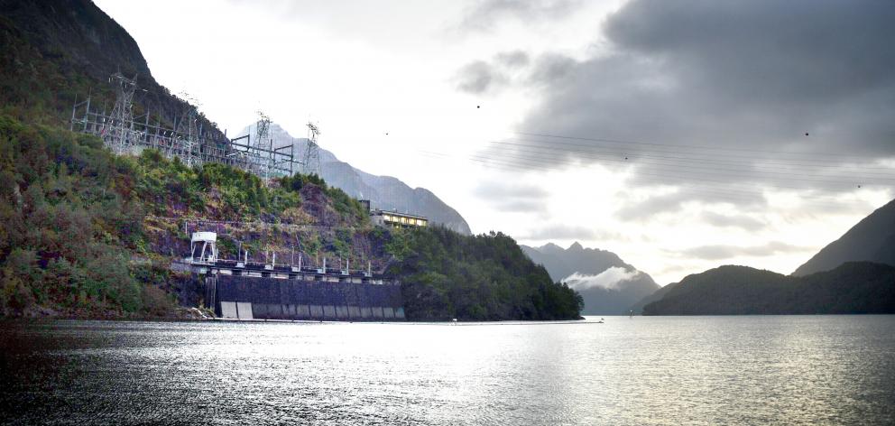
The Manapouri Power Station which produces power for the aluminium smelter at Tiwai Point and may power a hydrogen plant in the South.
PHOTO: LAURA SMITH


Kawasaki vice-executive officer Motohiko Nishimura, told Reuters the next phase of the project, already running, was to build a commercial-scale hydrogen carrier, fuelled by hydrogen, by the mid-2020s, with an aim to going commercial in 2030.

Korea Shipbuilding and Offshore Engineering is designing a tanker too; working with a steelmaker to develop high-strength steel and new welding technology, along with enhanced insulation, to contain the hydrogen and mitigate risks of pipes or tanks cracking.

A Norwegian shipping company is planning a "roll-on/roll-off" hydrogen carrier, and a Canadian company is developing a ship to transport compressed hydrogen gas, rather than liquefied gas, which does not need to be cooled to cryogenic temperatures.

Shipping is not the only concern for the electricity generators.

While New Zealand "green hydrogen" will have the environmental advantage of being made from a renewable source - hydro-electricity - the process is two or three times more expensive than making "blue hydrogen", which is made from fossil fuel such as natural gas.

The International Renewable Energy Agency is a champion of "green" hydrogen saying it is "essential" if aviation, international shipping and heavy industry are to reduce carbon emissions.

Helpfully for the two New Zealand electricity generators, the agency pointed out in a report earlier this year electricity accounts for much of the production cost.

It speculates it will be 10 years before green hydrogen is competitive with other fuels.

How well the proposal for the South stacks up will be the substance of Meridian and Contact’s "technical feasibility study" due to be completed by the end of the year. Mr Flannery said it will not be made public.

The two companies have also called for "registrations of interest" [ROI] from possible partners, and Mr Flannery said the process had confirmed "the significant global interest in using electricity in the lower South Island for hydrogen production".

"Our view is that hydrogen is the best form of new demand as it has the potential to create jobs, grow GDP and decarbonise New Zealand."

The ROIs are due to close at the end of this week.

A decision on whether the outcome will be made public has yet to be made.

There will be interest in whether giant Australian mining company Fortescue wants to join with Contact and Meridian or continue to pursue its own plans for a Southland hydrogen plant.

Radio New Zealand has reported Fortescue telling the Government production could begin as early as 2023.

But how Fortescue would get the hydrogen to overseas markets by that date is unclear, given Japan seems to be leading the way with shipping technology and is signalling it will not have a commercial vessel available until 2030.

Hurricane Ida Continues To Weigh On Gulf Oil Production

More than a week after Hurricane Ida made landfall in Louisiana, nearly 90 percent, or some 1,6 million bpd of U.S. Gulf oil production remains shut-in, more than 80 percent of natural gas production is offline, and less than half of the shut refineries have started to restart some processes. 

Operators in the U.S. Gulf of Mexico have identified damages to offshore facilities and looked to identify the source of an oil spill south off the coast of Port Fourchon, Louisiana, where Hurricane Ida made landfall on Sunday, August 29.  

A week later, as of Sunday, September 5, as many as 1.6 million barrels per day (bpd) of the Gulf of Mexico’s oil production was shut-in, equal to 88.32 percent of total crude output in the region, data from the Bureau of Safety and Environmental Enforcement (BSEE) showed. A total of 82.72 percent of the daily natural gas production in the Gulf was also shut-in as of Sunday evening. 

The shut-in oil production was lower than on Thursday, when 1.7 million bpd, or 93.55 percent, of all daily crude output was offline. 

Based on data from offshore operator reports submitted as of 11:30 CDT on Sunday, personnel have been evacuated from a total of 104 production platforms, or 18.57 percent of the 560 manned platforms in the Gulf of Mexico. 

Gulf of Mexico operators are assessing the situation on offshore facilities, while Port Fourchon remained in Recovery Phase on Saturday, with work progressing to get the port back up and running. 

Operations were restricted for daylight only to ensure the safety of first responders. The port typically handles significant industry traffic from offshore Gulf oil platforms and drilling rigs as well as the Louisiana Offshore Oil Port pipeline. 

Shell said last week that it had identified damage to its West Delta-143 offshore facilities, which serve as the transfer station for all production from the oil giant’s assets in the Mars corridor in the Mississippi Canyon area to onshore crude terminals. 

In the aftermath of Ida, divers hired by Talos Energy found on Sunday the possible source of an oil spill two miles offshore Port Fourchon in an unleased oilfield, Bay Marchand. A foot-long pipeline was bent and open, but none of the damaged pipelines are owned by Talos, the company said in a statement carried by Houston Chronicle. The spill hasn’t had an impact on wildlife or the shoreline, according to Talos. 

Apart from offshore oil and gas production, Hurricane Ida disrupted refinery operations in Louisiana, shutting 13 percent of American oil refining capacity right after the storm made landfall. 

A week later, five out of nine refineries that had shut in ahead of or during the storm remain shut, the U.S. Department of Energy said in its update on Hurricane Ida on Sunday. 

Five refineries in Louisiana remain shut, accounting for about 1.0 million bpd of refinery capacity, or around 6 percent, of U.S. operable refining capacity.

All three refineries in the Baton Rouge area and one near New Orleans—with a combined 1.3 million bpd refinery capacity—have initiated the restart process, but they are not expected to produce fuel at full rates for several days. 

Operations at the shut refineries cannot restart until feedstock supply, power, and other essential third-party utilities are restored, the DOE said. 

Operations also remain suspended at the Louisiana Offshore Oil Port (LOOP), and repairs are underway. LOOP—the only U.S. port capable of receiving very large crude carriers (VLCCs)—suspended operations at its marine terminal a day before Ida’s landfall per standard procedure.  

“Facility assessments and repairs continue,” LOOP said in its latest update Sunday, adding that it “continues to work with shippers to minimize storm-related impacts and is coordinating receipts and deliveries to regional refineries.” 

Gasoline prices in Louisiana spiked by $0.40 a gallon between the day of Ida’s landfall last Sunday, August 29, and this Sunday, September 5, according to AAA data. Gas prices in some counties are above $3 a gallon, while the state’s average price was $2.874/gal on September 5. 

As of early Sunday, 64.4 percent of Baton Rouge gas stations were without fuel, 64.3 percent of those in New Orleans, and 58.4 percent in Lafayette, Patrick De Haan, petroleum analyst for GasBuddy, said.

By Tsvetana Paraskova for Oilprice.com

Hurricane Ida Turned Into a Monster Because of a Giant Warm Patch in the Gulf of Mexico

Nick Shay
Professor of Oceanography, University of Miami
SUNDAY SEPTEMBER 5, 2021

A computer animation reflects the temperature change as eddies spin off from the Loop Current and Gulf Stream along the U.S. Coast.


As Hurricane Ida headed into the Gulf of Mexico, a team of scientists was closely watching a giant, slowly swirling pool of warm water directly ahead in its path.

That warm pool, an eddy, was a warning sign. It was around 125 miles (200 kilometers) across. And it was about to give Ida the power boost that in the span of less than 24 hours would turn it from a weak hurricane into the dangerous Category 4 storm that slammed into Louisiana just outside New Orleans on Aug. 29, 2021.

Nick Shay, an oceanographer at the University of Miami’s Rosenstiel School of Marine and Atmospheric Science, was one of those scientists. He explains how these eddies, part of what’s known as the Loop Current, help storms rapidly intensify into monster hurricanes.

How Do These Eddies Form?

The Loop Current is a key component of a large gyre, or circular current, rotating clockwise in the North Atlantic Ocean. Its strength is related to the flow of warm water from the tropics and Caribbean Sea into the Gulf of Mexico and out again through the Florida Straits, between Florida and Cuba. From there, it forms the core of the Gulf Stream, which flows northward along the Eastern Seaboard.

In the Gulf, this current can start to shed large warm eddies when it gets north of about the latitude of Fort Myers, Florida. At any given time, there can be as many as three warm eddies in the Gulf, slowly moving westward. When these eddies form during hurricane season, their heat can spell disaster for coastal communities around the Gulf.

Subtropical water has a different temperature and salinity than Gulf common water, so its eddies are easy to identify. They have warm water at the surface and temperatures of 78 degrees Fahrenheit (26 C) or more in water layers extending about 400 or 500 feet deep (about 120 to 150 meters). Since the strong salinity difference inhibits mixing and cooling of these layers, the warm eddies retain a considerable amount of heat.

When heat at the ocean surface is over about 78 F (26 C), hurricanes can form and intensify. The eddy that Ida passed over had surface temperatures over 86 F (30 C)

How Did You Know This Eddy Was Going To Be a Problem?


We monitor ocean heat content from space each day and keep an eye on the ocean dynamics, especially during the summer months. Keep in mind that warm eddies in the wintertime can also energize atmospheric frontal systems, such as the “storm of the century” that caused snowstorms across the Deep South in 1993.

To gauge the risk this heat pool posed for Hurricane Ida, we flew aircraft over the eddy and dropped measuring devices, including what are known as expendables. An expendable parachutes down to the surface and releases a probe that descends about 1,300 to 5,000 feet (400 to 1,500 meters) below the surface. It then sends back data about the temperature and salinity.

This eddy had heat down to about 480 feet (around 150 meters) below the surface. Even if the storm’s wind caused some mixing with cooler water at the surface, that deeper water wasn’t going to mix all the way down. The eddy was going to stay warm and continue to provide heat and moisture.

That meant Ida was about to get an enormous supply of fuel.

When warm water extends deep like that, we start to see the atmospheric pressure drop. The moisture transfers, or latent heat, from the ocean to atmosphere are sustained over the warm eddies since the eddies are not significantly cooling. As this release of latent heat continues, the central pressures continue to decrease. Eventually the surface winds will feel the larger horizontal pressure changes across the storm and begin to speed up.

That’s what we saw the day before Hurricane Ida made landfall. The storm was beginning to sense that really warm water in the eddy. As the pressure keeps going down, storms get stronger and more well defined.

When I went to bed at midnight that night, the wind speeds were about 105 miles per hour. When I woke up a few hours later and checked the National Hurricane Center’s update, it was 145 miles per hour, and Ida had become a major hurricane.

Is Rapid Intensification a New Development?

We’ve known about this effect on hurricanes for years, but it’s taken quite a while for meteorologists to pay more attention to the upper ocean heat content and its impact on the rapid intensification of hurricanes.

In 1995, Hurricane Opal was a minimal tropical storm meandering in the Gulf. Unknown to forecasters at the time, a big warm eddy was in the center of the Gulf, moving about as fast as Miami traffic in rush hour, with warm water down to about 150 meters. All the meteorologists saw in the satellite data was the surface temperature, so when Opal rapidly intensified on its way to eventually hitting the Florida Panhandle, it caught a lot of people by surprise.

Today, meteorologists keep a closer eye on where the pools of heat are. Not every storm has all the right conditions. Too much wind shear can tear apart a storm, but when the atmospheric conditions and ocean temperatures are extremely favorable, you can get this big change.

Hurricanes Katrina and Rita, both in 2005, had pretty much the same signature as Ida. They went over a warm eddy that was just getting ready to be shed form the Loop Current.

Hurricane Michael in 2018 didn’t go over an eddy, but it went over the eddy’s filament – like a tail – as it was separating from the Loop Current. Each of these storms intensified quickly before hitting land.

Of course, these warm eddies are most common right during hurricane season. You’ll occasionally see this happen along the Atlantic Coast, too, but the Gulf of Mexico and the Northwest Caribbean are more contained, so when a storm intensifies there, someone is going to get hit. When it intensifies close to the coast, like Ida did, it can be disastrous for coastal inhabitants.

What Does Climate Change Have To Do With It?


We know global warming is occurring, and we know that surface temperatures are warming in the Gulf of Mexico and elsewhere. When it comes to rapid intensification, however, my view is that a lot of these thermodynamics are local. How great a role global warming plays remains unclear.

This is an area of fertile research. We have been monitoring the Gulf’s ocean heat content for more than two decades. By comparing the temperature measurements we took during Ida and other hurricanes with satellite and other atmospheric data, scientists can better understand the role the oceans play in the rapid intensification of storms.

Once we have these profiles, scientists can fine-tune the computer model simulations used in forecasts to provide more detailed and accurate warnings in the futures.

This article is republished from The Conversation under a Creative Commons license. Read the original article.


Divers discover dislodged and broken pipeline that likely triggered Gulf of Mexico oil spill


By Keith Allen, CNN
Mon September 6, 2021


An oil slick is shown on September 2 south of Port Fourchon, Louisiana.

(CNN)Divers using underwater sonar discovered a 12-inch oil pipeline Sunday that had become dislodged and is possibly the source of an oil spill discovered off the coast of Louisiana, officials said

Houston-based Talos Energy said in a statement that it was informed of a potential oil release Tuesday by Clean Gulf Associates, a non-profit oil spill cooperative, because it previously leased the oil block in Bay Marchand off the coast of Port Fourchon, Louisiana.
Talos began sending vessels to the impacted area Wednesday and divers later discovered the damaged pipeline and determined it does not belong to Talos Energy, the company said.


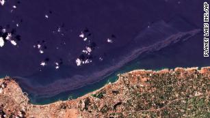
Syrian oil spill spreads across the Mediterranean and could reach Cyprus on Wednesday

The pipeline "appears to be bent and open ended," Talos Energy said.

Talos ended production in the area in 2017 and had its infrastructure removed from the site in 2019, the statement said.

"The source of the release is not proximate to any of the plugged wells, nor to the former locations of Talos subsea infrastructure," Talos said.

Two 95-foot response vessels remained on-site Sunday to assist with oil recovery, according to Talos' statement to CNN.

"The rate of the release appears to have decreased substantially over the last 48 hours and no black oil has been observed over the last 24 hours," Talos said Sunday. "To date, no impacts to shoreline or wildlife have been observed," according to the energy company.

Talos is working with the US Coast Guard and other state and federal agencies to determine ownership of the damaged pipeline and to organize a coordinated response to the spill, the company said


Cleanup boats on scene of large Gulf oil spill off Louisiana following Hurricane Ida

Bay Marchand slick 1 of several environmental hazards reported following storm

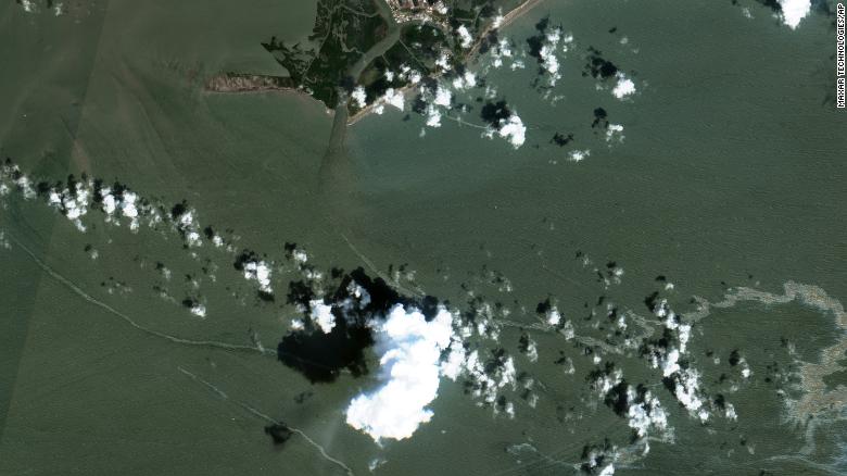
This satellite image taken on Sept. 2 shows an oil slick south of Port Fourchon, La. (Maxar Technologies/The Associated Press)

The U.S. Coast Guard said Saturday that cleanup crews are responding to a sizable oil spill in the Gulf of Mexico off Louisiana following Hurricane Ida.

The spill, which is ongoing, appears to be coming from a source underwater at an offshore drilling lease about three kilometres south of Port Fourchon, La. The reported location is near the site of a kilometres-long brown and black oil slick visible in aerial photos first published Wednesday by The Associated Press.

So far, the growing spill appears to have remained out to sea and has not impacted the Louisiana shoreline. There is not yet any estimate for how much oil was in the water, but recent satellite images reviewed by AP on Saturday appeared to show the slick drifting more than 19 kilometres eastward along the Gulf coast.

Coast Guard spokesperson Lt. John Edwards said response teams are monitoring reports and satellite imagery to determine the scope of the discharge. He said the source of the pollution is located in Bay Marchand, Block 4, and is believed to be crude oil from an undersea pipeline owned by Talos Energy.

Brian L. Grove, spokesperson for the Houston-based energy company, said it had hired Clean Gulf Associates to respond to the spill even though the company believes it is not responsible for the oil in the water.

Clean Gulf Associates, a nonprofit oil-spill response cooperative that works with the energy exploration and production industry, responded to the scene Wednesday. Its workers have placed a containment boom in the area to mitigate further spread of the oil. The company's vessels are also running skimmers that can remove oil from the water, though the Coast Guard said only about 160 litres had been removed so far.

Divers aim to find source of leak

Talos is investigating the cause of the leak, but a statement provided by Grove said that field observations indicate the company's assets are not the source. Talos previously leased Bay Marchand, Block 5, but ceased production there in 2017, plugged its wells and removed all pipeline infrastructure by 2019, according to the company.

Talos said two 29-metre response vessels had been dispatched to the scene to conduct oil recovery operations. A lift boat equipped to conduct dive operations has also been mobilized and was expected to arrive Saturday. The Coast Guard said the company had indicated divers would descend to the bottom on Sunday to determine the source of the leak.

"Talos will continue to work closely with the U.S. Coast Guard and other state and federal agencies to identify the source of the release and coordinate a successful response," the company's statement said. "The company's top priorities are the safety of all personnel and the protection of the public and environment."

Dozens of environmental hazards reported

The Bay Marchand spill is one of dozens of reported environmental hazards state and federal regulators are responding to in Lousiana and the Gulf following the Category 4 hurricane that made landfall at Port Fourchon on Sunday. The region is a major production centre of the U.S. petrochemical industry.

The AP also first reported Wednesday on images from a National Atmospheric and Oceanic Survey that showed extensive flooding and what appeared to be petroleum in the water at the sprawling Phillips 66 Alliance Refinery located along the Mississippi River south of New Orleans.

After AP published the photos, the Environmental Protection Agency tasked a specially outfitted survey aircraft to fly over that refinery on Thursday, as well as other industrial sites in area hardest hit by the hurricane's 240 km/h winds and storm surge.

The Louisiana Department of Environmental Quality said a state assessment team sent to the Alliance Refinery observed a spill of heavy oil being addressed with booms and absorbent pads. A levee meant to protect the plant had breached, allowing floodwaters to flow in during the storm and then back out as the surge receded.

State environmental officials said there was no estimate yet available for how much oil might have spilled from the refinery


Cleanup boats on scene of large Gulf oil spill

following Ida


An black slick drifts between damaged homes in the aftermath of Hurricane Ida 
Lafitte, La., Sept. 1, 2021. 
(AP Photo/Gerald Herbert)

Michael Biesecker
The Associated Press
Saturday, September 4, 2021 

WASHINGTON -- The U.S. Coast Guard said Saturday that cleanup crews are responding to a sizable oil spill in the Gulf of Mexico following Hurricane Ida.

The spill, which is ongoing, appears to be coming from a source underwater at an offshore drilling lease about two miles (three kilometers) south of Port Fourchon, Louisiana. The reported location is near the site of a miles-long brown and black oil slick visible in aerial photos first published Wednesday by The Associated Press.

So far, the growing spill appears to have remained out to sea and has not impacted the Louisiana shoreline. There is not yet any estimate for how much oil was in the water, but recent satellite images reviewed by AP on Saturday appeared to show the slick drifting more than a dozen miles (more than 19 kilometers) eastward along the Gulf coast.

Related Stories
Energy company: Hurricane Ida restoration could take weeks

Coast Guard spokesman Lt. John Edwards said response teams are monitoring reports and satellite imagery to determine the scope of the discharge. He said the source of the pollution is located in Bay Marchand, Block 4, and is believed to be crude oil from an undersea pipeline owned by Talos Energy.

Brian L. Grove, spokesman for the Houston-based energy company, said it had hired Clean Gulf Associates to respond to the spill even though the company believes it is not responsible for the oil in the water.

Clean Gulf Associates, a nonprofit oil-spill response cooperative that works with the energy exploration and production industry, responded to the scene Wednesday. Its workers have placed a containment boom in the area to mitigate further spread of the oil. The company's vessels are also running skimmers that can remove oil from the water, though the Coast Guard said only about 42 gallons (about 160 liters) had been removed so far.

Talos is investigating the cause of the leak, but a statement provided by Grove said that field observations indicate the company's assets are not the source. Talos previously leased Bay Marchand, Block 5, but ceased production there in 2017, plugged its wells and removed all pipeline infrastructure by 2019, according to the company.

Talos said two 95-foot (29-meter) response vessels had been dispatched to the scene to conduct oil recovery operations. A lift boat equipped to conduct dive operations has also been mobilized and is expected to arrive Saturday. The Coast Guard said the company had indicated divers would descend to the bottom on Sunday to determine the source of the leak.

"Talos will continue to work closely with the U.S. Coast Guard and other state and federal agencies to identify the source of the release and coordinate a successful response," the company's statement said. "The company's top priorities are the safety of all personnel and the protection of the public and environment."

The Bay Marchand spill is one of dozens of reported environmental hazards state and federal regulators are responding to in Lousiana and the Gulf following the Category 4 hurricane that made landfall at Port Fourchon on Sunday. The region is a major production center of the U.S. petrochemical industry.

The AP also first reported Wednesday on images from a National Atmospheric and Oceanic Survey that showed extensive flooding and what appeared to be petroleum in the water at the sprawling Phillips 66 Alliance Refinery located along the Mississippi River south of New Orleans.

After AP published the photos, the Environmental Protection Agency tasked a specially outfitted survey aircraft to fly over that refinery on Thursday, as well as other industrial sites in area hardest hit by the hurricane's 150-mph (240-kph) winds and storm surge.

The Louisiana Department of Environmental Quality said a state assessment team sent to the Alliance Refinery observed a spill of heavy oil being addressed with booms and absorbent pads. A levee meant to protect the plant had breached, allowing floodwaters to flow in during the storm and then back out as the surge receded.

State environmental officials said there was no estimate yet available for how much oil might have spilled from the refinery.


OIL COMPANY FORGETS TO MENTION

 LARGE OIL SPILL IN GULF OF MEXICO

THE COMPANIES GOT BUSTED BY

 SATELLITE IMAGERY.


Caught in the Act

A massive oil spill was discovered off the coast of Louisiana on Thursday.

The spill was identified using satellite imagery from space tech companies Planet Labs and Maxar Technologies, according to The New York Times. The images captured showed plumes of oil covering roughly 10 miles of the Gulf of Mexico.

US Coast Guard officials said that the spill likely originated from an old pipeline owned by Talos Energy, a Texas-based oil and gas company. Experts suspect that the pipeline was damaged due to Hurricane Ida.

NOAA Hurricane IDA Aerial Imagery Response
Publicly Available Aerial Imagery

The oil spill’s origin was initially identified by John Scott-Railton, senior researcher at research center The Citizen Lab. He had been using satellite imagery to investigate Hurricane Ida’s destruction.

“The fact that it was possible to find this spill is owed to the fact that NOAA made aerial imagery publicly available,” Scott-Railton told the NYT. “Had NOAA not made that public, it would have been a lot harder to uncover what is clearly an unfolding environmental problem.”

Cleanup Duty

There is currently an operation to clean up the oil spill, with US Coast Guard boats on their way to the site. However, the pipeline is still leaking.

The US Bureau of Safety and Environmental Enforcement released a media update on Friday saying workers from 133 production platforms and six drilling rigs have been evacuated. The bureau intends to inspect the facilities and said that those with no damage “will be brought back online immediately.”

This is yet another example of how one result of manmade climate change (i.e. Hurricane Ida) can cause even more destruction on our environment (i.e. massive oil spills). It also highlights the massive vulnerabilities our energy infrastructure can have in light of disaster — especially when that infrastructure depends on an environmentally harmful resource like oil.


READ MORE: Satellite Images Find ‘Substantial’ Oil Spill in Gulf After Ida [NYT]

More on oil disasters: Oil Company That Caught Ocean on Fire Has Staggeringly Long History of Deaths, Accidents

TotalEnergies Splurges $27 Billion On Iraqi Oil And Solar Projects

TotalEnergies has inked a deal with the Iraqi government to invest $27 billion in the country's energy industry over 15 years, the Wall Street Journal has reported, citing unnamed sources familiar with the deal.

According to the WSJ's sources, among the projects considered would be a seawater injection project aimed at boosting the rate of oil recovery at several fields in southern Iraq as well as a solar farm project. The initial sum TotalEnergies will invest in Iraq is $10 billion.

These projects should help improve Iraq's highly unreliable electricity supply, which is plagued by shortages that cause unrest among the population. It could also reduce its dependence on imports of natural gas from neighbor Iran, for which Baghdad has several times come under fire from the United States.

Currently, Iraq imports a third of the electricity and natural gas that it consumes from Iran and has accumulated debts of some $6 billion for the energy it purchased.

"This is the largest investment in Iraq by a Western company," said Iraqi oil minister Ihsan Abdul Jabbar Ismail, as quoted by the AFP. "Implementing these projects is the challenge we face now."

According to the AFP, the collaboration will see the output from the Artawi field increase from 85,000 bpd to as much as 210,000 bpd. It will also reduce flaring and direct the gas that would have otherwise been flared to electricity production.

The gas recovery project will see associated gas collected from five Basra oil fields, including Ratawi, West Qurna 2, Majnoon, Luhais, and Tuba, and processed at a rate of 600 million cu ft daily, Argus reported. The result will be some 12,000 bpd of condensate and 3,000 tons daily of liquid petroleum gas.

As for the solar project, the AFP cited an unnamed Iraqi source who said the plans are to build a 1-GW solar farm at the Artawi field. According to the Iraqi government, electricity produced at solar farms "costs 45 percent less than that produced by traditional power stations".

By Irina Slav for Oilprice.com

e.e.cummings would approve
Calgary professor won't use capital letters unless it's to acknowledge Indigenous people


Jeremiah Rodriguez
CTVNews.ca Writer
Monday, September 6, 2021 


A photo of linda manyguns, associate vice-president of Indigenization and decolonization at Mount Royal University. (Courtesy of Mount Royal University)

TORONTO -- A Calgary professor says she won’t use capital letters in her name or anything she writes, unless it pertains to Indigenous people.

linda manyguns, associate vice-president of Indigenization and decolonization at Mount Royal University, made the decision to “support the movement for equality,” following the ongoing discoveries of unmarked graves at residential schools in Canada.

CTV News will not be using capital letters for manyguns’ name or quotes attributed to her.

Related Stories
Recovery of children in unmarked graves at the top of First Nations election priorities
Pamela Palmater: How serious are the federal leaders about reconciliation with Indigenous people?
What is National Day for Truth and Reconciliation, and who gets the statutory holiday?

Related Links
See more on linda manyguns' decision here

She is refusing to use capital letters because she said it shows complicity with systems of oppression. She called on people to reject symbols of hierarchies, such as churches and the government, and be more critical of them because “these institutions have been responsible for atrocities.”

“i'm joining that [lower case] movement in order to create a resistance to their oppression; identify and bring attention to the fact that these entities are the oppressors of Aboriginal people,” manyguns told CTVNews.ca in a phone interview on Monday.

So far, there have been more than 1,000 unmarked graves found at the former sites of church and government-run residential schools. The Truth And Reconciliation Commission estimates that between 4,100 to 6,000 children died while they attended these schools.

For decades, more than 150,000 First Nations, Inuit and Metis children were forcibly removed from their families to attend these schools which sought to strip away their culture and languages.

So out of respect for them, manyguns said she’ll only use capital letters when it comes to words, such as “Indigenous,” “Indigeneity,” or references to the “Indigenous struggle for recognition.”

Although her specific university department will follow her example, manyguns doesn’t want to force anything on anyone else. But she did urge institutions pledging to bring in more Indigenous voices or perspectives in their decision-making to first deeply think about de-colonization and how systemic oppression persists today.

Last week, she announced her decision to only use lowercase in a post on the university’s website, where she said, “Indigenous people have been actively engaged in a multidimensional struggle for equality, since time immemorial.”

“we strive for historical-cultural recognition and acknowledgment of colonial oppression that persistently devalues the diversity of our unique cultural heritages,” she wrote.

“these sites of struggle are generally found at blockades, where demonstrations against racism occur, where racialization and cultural domination, and discrimination leave the mark of imbalance and abuses of power.”

--

If you are a former residential school student in distress, or have been affected by the residential school system and need help, you can contact the 24-hour Indian Residential Schools Crisis Line: 1-866-925-4419

Additional mental-health support and resources for Indigenous people are available here.


WE MAY FINALLY KNOW WHERE HIGH-ENERGY COSMIC RAYS COME FROM


High-energy cosmic rays have proven elusive ... but we may have found their source.


Shutterstock


MATT WILLIAMS
9.5.2021 

Roughly a century ago, scientists began to realize that some of the radiation we detect in Earth’s atmosphere is not local in origin.

This eventually gave rise to the discovery of cosmic rays — high-energy protons and atomic nuclei that have been stripped of their electrons and accelerated to relativistic speeds (close to the speed of light).

However, there are still several mysteries surrounding this strange (and potentially lethal) phenomenon. This includes questions about their origins and how the main component of cosmic rays (protons) are accelerated to such high velocity.

Thanks to new research led by the University of Nagoya, scientists have quantified the number of cosmic rays produced in a supernova remnant for the first time. This research has helped resolve a 100-year mystery and is a major step towards determining precisely where cosmic rays come from.

While scientists theorize that cosmic rays originate from many sources — our Sun, supernovae, gamma-ray bursts (GRBs), and active galactic nuclei (sometimes called quasars) — their exact origin has been a mystery since they were first discovered in 1912. Similarly, astronomers have theorized that supernova remnants (the after-effects of supernova explosions) are responsible for accelerating them to nearly the speed of light.


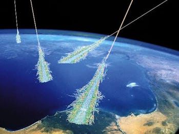
Showers of high-energy particles occur when energetic cosmic rays strike the top of the Earth’s atmosphere. Cosmic rays were discovered unexpectedly in 1912.
Illustration Credit: Simon Swordy (U. Chicago), NASA.

As they travel through our galaxy, cosmic rays play a role in the chemical evolution of the interstellar medium (ISM). As such, understanding their origin is critical to understanding how galaxies evolve.

In recent years, improved observations have led some scientists to speculate that supernova remnants give rise to cosmic rays because the protons they accelerate interact with protons in the ISM to create very high-energy (VHE) gamma rays.

However, gamma-rays are also produced by electrons that interact with photons in the ISM, which can be in the form of infrared photons or radiation from the Cosmic Microwave Background (CMB). Therefore, determining which source is greater is paramount to determining the origin of cosmic rays.

Hoping to shed light on this, the research team — which included members from Nagoya University, the National Astronomical Observatory of Japan (NAOJ), and the University of Adelaide, Australia — observed the supernova remnant RX J1713.7?3946 (RX J1713).

The key to their research was the novel approach they developed to quantify the source of gamma-rays in interstellar space. Past observations have shown that the intensity of VHE gamma-rays caused by protons colliding with other protons in the ISM is proportional to the interstellar gas density, which is discernible using radio-line imaging.

On the other hand, gamma-rays caused by the interaction of electrons with photons in the ISM are also expected to be proportional to the intensity of nonthermal X-rays from electrons.

For the sake of their study, the team relied on data obtained by the High Energy Stereoscopic System (HESS), a VHE gamma-ray observatory located in Namibia (and operated by the Max Planck Institute for Nuclear Physics). They then combined this with X-ray data obtained by the ESA’s X-ray Multi-Mirror Mission (XMM-Newton) observatory and data on the distribution of gas in the interstellar medium.

They then combined all three data sets and determined that protons account for 67 ± 8% of cosmic rays while cosmic-ray electrons account for 33 ± 8% — roughly a 70/30 split. These findings are groundbreaking since they are the first time that the possible origins of cosmic rays have been quantified. They also constitute the most definitive evidence to date that supernova remnants are the source of cosmic rays.

These results also demonstrate that gamma-rays from protons are more common in gas-rich interstellar regions, whereas those caused by electrons are enhanced in the gas-poor regions. This supports what many researchers have predicted, which is that the two mechanisms work together to influence the evolution of the ISM. Said Emeritus Professor Yasuo Fukui, who was the study’s lead author:
“This novel method could not have been accomplished without international collaborations. [It] will be applied to more supernova remnants using the next-generation gamma-ray telescope CTA (Cherenkov Telescope Array) in addition to the existing observatories, which will greatly advance the study of the origin of cosmic rays.”

In addition to leading this project, Fukui has been working to quantify interstellar gas distribution since 2003 using the NANTEN radio telescope at the Las Campanas Observatory in Chile and the Australia Telescope Compact Array.

Thanks to Professor Gavin Rowell and Dr. Sabrina Einecke of the University of Adelaide (co-authors on the study) and the H.E.S.S. team, the spatial resolution, and sensitivity of gamma-ray observatories have finally reached the point where it is possible to draw comparisons between the two.

Meanwhile, co-author Dr. Hidetoshi Sano of the NAOJ led the analysis of archival datasets from the XMM-Newton observatory. In this respect, this study also shows how international collaborations and data-sharing are enabling all kinds of cutting-edge research. Along with improved instruments, improved methods and greater opportunities for cooperation are leading to an age where astronomical breakthroughs are becoming a regular occurrence!

This article was originally published on Universe Today by MATT WILLIAMS. Read the original article here.