Divers discover dislodged and broken pipeline that likely triggered Gulf of Mexico oil spill
By Keith Allen, CNN
Mon September 6, 2021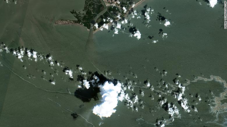
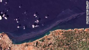
An oil slick is shown on September 2 south of Port Fourchon, Louisiana.
Talos began sending vessels to the impacted area Wednesday and divers later discovered the damaged pipeline and determined it does not belong to Talos Energy, the company said.
Syrian oil spill spreads across the Mediterranean and could reach Cyprus on Wednesday
The pipeline "appears to be bent and open ended," Talos Energy said.
Talos ended production in the area in 2017 and had its infrastructure removed from the site in 2019, the statement said.
"The source of the release is not proximate to any of the plugged wells, nor to the former locations of Talos subsea infrastructure," Talos said.
Two 95-foot response vessels remained on-site Sunday to assist with oil recovery, according to Talos' statement to CNN.
"The rate of the release appears to have decreased substantially over the last 48 hours and no black oil has been observed over the last 24 hours," Talos said Sunday. "To date, no impacts to shoreline or wildlife have been observed," according to the energy company.
Talos is working with the US Coast Guard and other state and federal agencies to determine ownership of the damaged pipeline and to organize a coordinated response to the spill, the company said
Cleanup boats on scene of large Gulf oil spill off Louisiana following Hurricane Ida
Bay Marchand slick 1 of several environmental hazards reported following storm

The U.S. Coast Guard said Saturday that cleanup crews are responding to a sizable oil spill in the Gulf of Mexico off Louisiana following Hurricane Ida.
The spill, which is ongoing, appears to be coming from a source underwater at an offshore drilling lease about three kilometres south of Port Fourchon, La. The reported location is near the site of a kilometres-long brown and black oil slick visible in aerial photos first published Wednesday by The Associated Press.
So far, the growing spill appears to have remained out to sea and has not impacted the Louisiana shoreline. There is not yet any estimate for how much oil was in the water, but recent satellite images reviewed by AP on Saturday appeared to show the slick drifting more than 19 kilometres eastward along the Gulf coast.
Coast Guard spokesperson Lt. John Edwards said response teams are monitoring reports and satellite imagery to determine the scope of the discharge. He said the source of the pollution is located in Bay Marchand, Block 4, and is believed to be crude oil from an undersea pipeline owned by Talos Energy.
Brian L. Grove, spokesperson for the Houston-based energy company, said it had hired Clean Gulf Associates to respond to the spill even though the company believes it is not responsible for the oil in the water.
Clean Gulf Associates, a nonprofit oil-spill response cooperative that works with the energy exploration and production industry, responded to the scene Wednesday. Its workers have placed a containment boom in the area to mitigate further spread of the oil. The company's vessels are also running skimmers that can remove oil from the water, though the Coast Guard said only about 160 litres had been removed so far.
Divers aim to find source of leak
Talos is investigating the cause of the leak, but a statement provided by Grove said that field observations indicate the company's assets are not the source. Talos previously leased Bay Marchand, Block 5, but ceased production there in 2017, plugged its wells and removed all pipeline infrastructure by 2019, according to the company.
Talos said two 29-metre response vessels had been dispatched to the scene to conduct oil recovery operations. A lift boat equipped to conduct dive operations has also been mobilized and was expected to arrive Saturday. The Coast Guard said the company had indicated divers would descend to the bottom on Sunday to determine the source of the leak.
"Talos will continue to work closely with the U.S. Coast Guard and other state and federal agencies to identify the source of the release and coordinate a successful response," the company's statement said. "The company's top priorities are the safety of all personnel and the protection of the public and environment."
Dozens of environmental hazards reported
The Bay Marchand spill is one of dozens of reported environmental hazards state and federal regulators are responding to in Lousiana and the Gulf following the Category 4 hurricane that made landfall at Port Fourchon on Sunday. The region is a major production centre of the U.S. petrochemical industry.
The AP also first reported Wednesday on images from a National Atmospheric and Oceanic Survey that showed extensive flooding and what appeared to be petroleum in the water at the sprawling Phillips 66 Alliance Refinery located along the Mississippi River south of New Orleans.
After AP published the photos, the Environmental Protection Agency tasked a specially outfitted survey aircraft to fly over that refinery on Thursday, as well as other industrial sites in area hardest hit by the hurricane's 240 km/h winds and storm surge.
The Louisiana Department of Environmental Quality said a state assessment team sent to the Alliance Refinery observed a spill of heavy oil being addressed with booms and absorbent pads. A levee meant to protect the plant had breached, allowing floodwaters to flow in during the storm and then back out as the surge receded.
State environmental officials said there was no estimate yet available for how much oil might have spilled from the refinery

An black slick drifts between damaged homes in the aftermath of Hurricane Ida
The Associated Press
Saturday, September 4, 2021
WASHINGTON -- The U.S. Coast Guard said Saturday that cleanup crews are responding to a sizable oil spill in the Gulf of Mexico following Hurricane Ida.
The spill, which is ongoing, appears to be coming from a source underwater at an offshore drilling lease about two miles (three kilometers) south of Port Fourchon, Louisiana. The reported location is near the site of a miles-long brown and black oil slick visible in aerial photos first published Wednesday by The Associated Press.
So far, the growing spill appears to have remained out to sea and has not impacted the Louisiana shoreline. There is not yet any estimate for how much oil was in the water, but recent satellite images reviewed by AP on Saturday appeared to show the slick drifting more than a dozen miles (more than 19 kilometers) eastward along the Gulf coast.
Related Stories
Energy company: Hurricane Ida restoration could take weeks
Coast Guard spokesman Lt. John Edwards said response teams are monitoring reports and satellite imagery to determine the scope of the discharge. He said the source of the pollution is located in Bay Marchand, Block 4, and is believed to be crude oil from an undersea pipeline owned by Talos Energy.
Brian L. Grove, spokesman for the Houston-based energy company, said it had hired Clean Gulf Associates to respond to the spill even though the company believes it is not responsible for the oil in the water.
Clean Gulf Associates, a nonprofit oil-spill response cooperative that works with the energy exploration and production industry, responded to the scene Wednesday. Its workers have placed a containment boom in the area to mitigate further spread of the oil. The company's vessels are also running skimmers that can remove oil from the water, though the Coast Guard said only about 42 gallons (about 160 liters) had been removed so far.
Talos is investigating the cause of the leak, but a statement provided by Grove said that field observations indicate the company's assets are not the source. Talos previously leased Bay Marchand, Block 5, but ceased production there in 2017, plugged its wells and removed all pipeline infrastructure by 2019, according to the company.
Talos said two 95-foot (29-meter) response vessels had been dispatched to the scene to conduct oil recovery operations. A lift boat equipped to conduct dive operations has also been mobilized and is expected to arrive Saturday. The Coast Guard said the company had indicated divers would descend to the bottom on Sunday to determine the source of the leak.
"Talos will continue to work closely with the U.S. Coast Guard and other state and federal agencies to identify the source of the release and coordinate a successful response," the company's statement said. "The company's top priorities are the safety of all personnel and the protection of the public and environment."
The Bay Marchand spill is one of dozens of reported environmental hazards state and federal regulators are responding to in Lousiana and the Gulf following the Category 4 hurricane that made landfall at Port Fourchon on Sunday. The region is a major production center of the U.S. petrochemical industry.
The AP also first reported Wednesday on images from a National Atmospheric and Oceanic Survey that showed extensive flooding and what appeared to be petroleum in the water at the sprawling Phillips 66 Alliance Refinery located along the Mississippi River south of New Orleans.
After AP published the photos, the Environmental Protection Agency tasked a specially outfitted survey aircraft to fly over that refinery on Thursday, as well as other industrial sites in area hardest hit by the hurricane's 150-mph (240-kph) winds and storm surge.
The Louisiana Department of Environmental Quality said a state assessment team sent to the Alliance Refinery observed a spill of heavy oil being addressed with booms and absorbent pads. A levee meant to protect the plant had breached, allowing floodwaters to flow in during the storm and then back out as the surge receded.
State environmental officials said there was no estimate yet available for how much oil might have spilled from the refinery.
THE COMPANIES GOT BUSTED BY
Caught in the Act
A massive oil spill was discovered off the coast of Louisiana on Thursday.
The spill was identified using satellite imagery from space tech companies Planet Labs and Maxar Technologies, according to The New York Times. The images captured showed plumes of oil covering roughly 10 miles of the Gulf of Mexico.
US Coast Guard officials said that the spill likely originated from an old pipeline owned by Talos Energy, a Texas-based oil and gas company. Experts suspect that the pipeline was damaged due to Hurricane Ida.

Publicly Available Aerial Imagery
The oil spill’s origin was initially identified by John Scott-Railton, senior researcher at research center The Citizen Lab. He had been using satellite imagery to investigate Hurricane Ida’s destruction.
“The fact that it was possible to find this spill is owed to the fact that NOAA made aerial imagery publicly available,” Scott-Railton told the NYT. “Had NOAA not made that public, it would have been a lot harder to uncover what is clearly an unfolding environmental problem.”
Cleanup Duty
There is currently an operation to clean up the oil spill, with US Coast Guard boats on their way to the site. However, the pipeline is still leaking.
The US Bureau of Safety and Environmental Enforcement released a media update on Friday saying workers from 133 production platforms and six drilling rigs have been evacuated. The bureau intends to inspect the facilities and said that those with no damage “will be brought back online immediately.”
This is yet another example of how one result of manmade climate change (i.e. Hurricane Ida) can cause even more destruction on our environment (i.e. massive oil spills). It also highlights the massive vulnerabilities our energy infrastructure can have in light of disaster — especially when that infrastructure depends on an environmentally harmful resource like oil.
READ MORE: Satellite Images Find ‘Substantial’ Oil Spill in Gulf After Ida [NYT]
More on oil disasters: Oil Company That Caught Ocean on Fire Has Staggeringly Long History of Deaths, Accidents
No comments:
Post a Comment