Sunday, January 23, 2022


2,500 Americans signatories demand Blinken to stop ethnic cleansing of Al-Naqab

WASHINGTON, Sunday, January 23, 2022 (WAFA) – Nearly 2,500 Americans have signed a petition calling on US Secretary of State Anthony Blinken to intervene to stop the Israeli ethnic cleansing campaign against the Palestinian citizens of Al-Naqab, a region which makes up almost a half of the area of historic Palestine.

Launched by Code Pink, a women's organization that supports Palestinian rights, the petition states that "since 1948, the Jewish National Fund (JNF) has been planting trees to displace Palestinians from their lands. They are currently carrying out an afforestation project in the Negev/Naqab (Southern Israel) on land used by Bedouin communities for agriculture. They aim to drive the Bedouins from their lands. "

The petition asks Blinken to immediately halt the afforestation in the Palestinian communities. It details how the Jewish National Fund was established in 1901 for the purpose of buying and developing land for Jewish settlement in Palestine.

Code Pink noted that the JNF "played a central role in the plans to expel Palestinians from their lands. They meticulously charted topography, roads, land, and water sources and profiled the entire Palestinian population by age, political affiliations, and hostility to the Zionist project. Known as the Village Files, these documents became a crucial military tool for Jewish militias, who in 1948 burned villages, carried out massacres, and drove around 750,000 Palestinians out of their homes and villages, making them refugees."

The petition adds that the Israeli government has been working tirelessly to expel Palestinian Bedouin populations that are Israeli citizens from the Al-Naqab desert, south of occupied Palestine. The community of Al-Araqeeb has been demolished over 100 times since it is situated in Bedouin agricultural areas, where the JNF is currently carrying out its afforestation/ethnic cleansing program.

The petition asks Blinken to use his position as Secretary of State to pressure "Israel" and the JNF to end the afforestation project in Al-Naqab and stop displacing Palestinians from their lands and dwellings.

M.N

Civil society questions Facebook for delaying India human rights impact assessment report
A consortium of 25 civil society organisations Wednesday published a letter sent to Facebook on January 3 2021, against the delayed release of the India Human Rights Impact Assessment (HRIA) report and lack of action towards addressing grave concerns about the company’s human rights record in India.

The letter was sent to the Facebook Director of Human Rights, Miranda Sissons, reminding the company that the HRIA is an important way through which the company can evaluate its role in spreading hate speech and incitement violence on its services in India. India is the company’s largest market and reports of whistleblowers such as Frances Haugen, Sophie Zhang and former Facebook Vice President Brian Boland, have made it clear that Facebook’s platform has been used to target Muslims and other minorities in India.

The organizations stated:

The current perception is that Facebook is not committed to respecting rights in this case…The UN Guiding Principles on Business and Human Rights are clear that transparency is a key aspect of human rights due diligence and that in order to account for how they address human rights impacts, companies should be prepared to communicate this externally, particularly when concerns are raised by or on behalf of the affected stakeholders.

In 2020, Facebook (now Meta) had commissioned the law firm Foley Hoag to conduct a Human Rights Impact Assessment (HRIA) for India. The Wall Street Journal recently reported civil society apprehensions about Facebook narrowing the scope of the report by making technical objections and demanding more data. Facebook has yet to respond to the letter or issue any date for the full publication of the HRIA report.

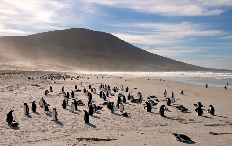
Let us celebrate Penguin Awareness Day with Falklands one of the world's great penguin capitals

Friday, January 21st 2022 -
As many as a million penguins nest in the Falklands every summer, representing five of the world’s eighteen species, King, Gentoo, Rockhopper, Magellanic and Macaroni

Penguin Awareness Day is celebrated annually on the 20th of January and this year was on Thursday. The founder of Penguin Awareness Day is unknown, and there is no information on when this day was first celebrated.

However, it is known Penguin Awareness Day is celebrated to help raise awareness about the dwindling of numbers of these beautiful black and while creatures, primarily due to human activity. Emperor Penguins are the tallest… about 4 feet tall, the smallest, Little Blue, stand about 16 inches. Awareness Day hopes to shine a light on the importance of conservation of penguin habitats, and also intends to communicate the impacts of climate change on the region.

Scientific reports indicate that penguin populations, particularly Emperor Penguin populations, are declining and research shows that the world's second-largest Emperor penguin colony has declined by 88%.

Penguin Awareness Day gives people the opportunity to learn about these incredible animals, such as how they have managed to survive in harsh climate conditions for over 65 million years, and understand how climate change is impacting them.

Some facts about penguins,

In the water, a group of penguins is called a raft. But when they are on land, they are called a waddle. They nest in rookeries.

Penguins' distinctive black and white markings are a form of camouflage called 'counter-shading'.

Penguins love a cuddle! Or rather, a huddle, which keeps them warm and safe from predators.

Penguins are great divers, Emperor Penguins can dive 530 meters deep. Not only are they great swimmers, up to about 22 mph, they're also great walkers and can walk up to 60 miles across sea ice.

But penguins are also an iconic feature of the Falkland Islands, represented in crests, symbols and in colored prints of all kinds, and have become one of the great attractions of the South Atlantic archipelago.

In effect the Falkland Islands are considered one of the world’s great penguin capitals: as many as a million penguins nest in the Falklands every summer, representing five of the world’s eighteen species – King, Gentoo, Rockhopper, Magellanic and Macaroni. Actually for the Gentoo, Falklands are home to the largest population on Earth.

It must also be mentiones that there is another celebratory date for penguins, April 25th, World Penguin Day, which coincides with the annual northern migration of Adelie penguins. This intrinsic migration pattern is conserved across generations. Native to Antarctica are six breeding species, Emperor, King, Chinstrap, Adelie, Gentoo and Macaroni penguins.


Most penguins are monogamous and have distinct calls, enabling them to locate their mates in large groups. Penguin species lay up to two eggs per mating season with the Emperor and King penguins laying only one egg. Alarmingly, of the 18 recognized living species, 11 have been listed as Vulnerable or Endangered.

National Penguin Day began in 1972 when Gerry Wallace wrote the event on his wife’s (Aleta’s) calendar in Alamogordo, California. They later brought the celebration to the US Naval Weapons Center in Ridgecrest, California where the Penguin Patrol made the news.

As climate change melts Antarctic ice, gentoo penguins venture further south

by Mongabay.com on 21 January 2022

Researchers have discovered a new colony of gentoo penguins in Antarctica previously unknown to science.

The colony was found on Andersson Island on the east side of the Antarctic Peninsula, which is the furthest south the species has ever been found in that region.

Scientists say climate change played a key role in the penguins’ presence on the island, as warming temperatures and record ice melt make new locations habitable for the species.

Scientists and conservationists are making renewed calls to establish a network for marine protected areas in Antarctica to help safeguard the region as the climate rapidly changes.

The crew of the M/V Arctic Sunrise, an icebreaker vessel owned by Greenpeace, were sailing through Antarctica’s Weddell Sea this month when they saw something they didn’t expect.

“One of the scientists on board, Alex Borowicz … was looking through the binoculars from the bridge of our ship,” Louisa Casson, an ocean campaigner with Greenpeace UK currently on board the Arctic Sunrise, told Mongabay in a video interview. “He spotted what he thought looked like a penguin colony, where we had seen no previous records.”

As the ship drew near, the crew discovered a colony of gentoo penguins (Pygoscelis papua) consisting of about 75 chicks living on Andersson Island on the east side of the Antarctic Peninsula, previously unknown to science. Scientists say this is the furthest south the species has ever been seen in this part of Antarctica, and posit their presence here to the impacts of climate change
.

Researchers just discovered a new colony of gentoo penguins on Andersson Island on the east side of the Antarctic Peninsula. Image © Tomás Munita / Greenpeace.

“It’s may be a cliché at this point, but they’re the canary in the coal mine for climate change because they’re so closely tied to those sea ice conditions,” Heather Lynch, an Antarctic penguin expert at Stony Brook University in New York and the remote leader of the expedition, told Mongabay in a video interview.

Gentoo penguins are generally found across the sub-Antarctic region, with the largest colonies on the Falkland Islands, South Georgia and parts of the Antarctic Peninsula. Unlike other penguin species that migrate to feed or breed, gentoo penguins will stay in the same place in both summer and winter, so conditions have to be ideal for them to survive year-round in a given location.

“They’re very opportunistic, so any chance they get, they’re going to colonize rock as the glaciers retreat,” Lynch said. “So they’re the thing that we tend to use to see how far climate change has gone in terms of turning the Antarctic Peninsula into a more sub-Antarctic or more temperate climate.”

Glacial ice around Antarctica has been melting at an alarming rate as climate change heats up the planet. A 2019 study found that Antarctica’s ice was melting six times faster than it was in the 1970s. Scientists have been keeping a particularly close eye on the Thwaites Glacier, known as the “Doomsday Glacier,” which, if it melted entirely, could raise global sea levels by several meters.

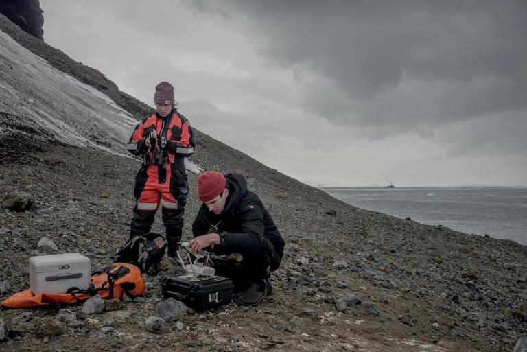
Scientists Clare Flynn and Michael Wethington fly a drone over a penguin colony on Andersson Island, Antartica. Image © Tomás Munita / Greenpeace.

But it’s not just sea level rise that would be impacted by the melting of Antarctica’s ice — it could change ocean currents, influence weather patterns as far as the tropics, and disturb krill populations that many species depend upon, including penguins, whales and fish.

Scientists and conservationists have been advocating for the establishment of three new marine protected areas (MPAs) in the Antarctic region, including East Antarctica, the Antarctic Peninsula and the Weddell Sea, which would cover about 4 million square kilometers (1.5 million square miles) of the Southern Ocean, arguing that such a move is essential in helping the region withstand the innumerable impacts of climate change, as well as the additional pressure of industrial krill fishing. The international body responsible for making such a decision is the Commission for the Conservation of Antarctic Marine Living Resources (CCAMLR), but it has repeatedly failed to agree upon the establishment of these MPAs.

Casson said the CCAMLR originally set itself a deadline of 2012 to set up the network of MPAs “precisely to protect penguins because they’re experiencing all of this change” — but nothing has happened in the nearly 10 years since.

“We know that marine protected areas are a really important tool in helping wildlife adapt to and build resilience to ongoing changes,” Casson said.

The Arctic Sunrise is halfway through its expedition of the Weddell Sea. In addition to surveys of gentoo penguins, it will be looking at Adélie (Pygoscelis adeliae) and chinstrap penguin (Pygoscelis antarcticus) populations.

“We hope to make a stronger scientific case for why these areas should be protected,” Casson said, “and to also raise public pressure on governments so that they finally reach agreement and get the Antarctic protected as it should be, and as it should have been long ago.”

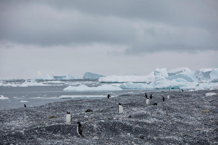
Gentoo and Adélie penguins on Andersson Island in Antarctica. Image © Tomás Munita / Greenpeace.

Citations:

Armitage, T. W., Manucharyan, G. E., Petty, A. A., Kwok, R., & Thompson, A. F. (2020). Enhanced eddy activity in the Beaufort gyre in response to sea ice loss. Nature Communications, 11(1). doi:10.1038/s41467-020-14449-z

Fuentes, V., Alurralde, G., Meyer, B., Aguirre, G. E., Canepa, A., Wölfl, A., … Schloss, I. R. (2016). Glacial melting: An overlooked threat to Antarctic krill. Scientific Reports, 6(1). doi:10.1038/srep27234

Rignot, E., Mouginot, J., Scheuchl, B., van den Broeke, M., van Wessem, M. J., & Morlighem, M. (2019). Four decades of Antarctic Ice Sheet mass balance from 1979–2017. Proceedings of the National Academy of Sciences, 116(4). doi:10.1073/pnas.1812883116

Banner image caption: Gentoo penguins on Andersson Island in Antarctica. Image © Tomás Munita / Greenpeace.
The drifting giant A68 iceberg released billions of tons of fresh water in South Georgia ecosystem

Saturday, January 22nd 2022 -
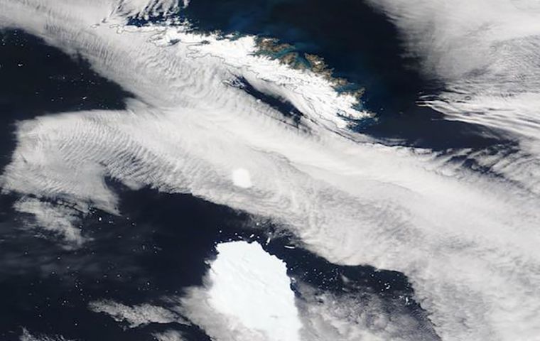
Satellite images shows A68a heading towards the sub-Antarctic island of South Georgia. Credit: MODIS from NASA Worldview Snapshots

Scientists monitoring the giant A68a iceberg from space reveal that a huge amount of freshwater was released as it melted around the sub-Antarctic island of South Georgia. An estimated 152 billion tons of freshwater – equivalent to 20 x Loch Ness or 61 million Olympic sized swimming pools, entered the seas around the sub-Antarctic island of South Georgia when A68a melted over three months in 2020/2021, according to a new study published this month by the British Antarctic Survey.

In July 2017, A68a calved off the Larsen-C Ice Shelf on the Antarctic Peninsula and began its epic three-and-a-half year, 4.000 km journey across the Southern Ocean. At 5719 square kilometers – about a quarter the size of Wales – it was the biggest iceberg on Earth when it formed and the sixth largest on record. Around Christmas 2020, the berg received widespread attention as it drifted worryingly close to South Georgia, raising concerns it could harm the island’s fragile ecosystem.

A team from Center for Polar Observation and Modeling and BAS used satellite measurements to chart the iceberg’s area and thickness change throughout its life cycle. The authors show that the iceberg had melted enough as it drifted to avoid damaging the sea floor around South Georgia by running aground. However, a side effect of the melting was the release of a colossal 152 billion tons of fresh water in close proximity to the island – a disturbance that could have a profound impact on the island’s marine habitat.

For the first two years of its life, A68a stayed close to Antarctica in the cold waters of the Weddell Sea and experienced little in the way of melting. However, once it began its northwards journey across the Drake Passage it traveled through increasingly warm waters and began to melt. Altogether, the iceberg thinned by 67 meters from its initial 235 m thickness, with the rate of melting rising sharply as the berg drifted around South Georgia.

Laura Gerrish, GIS and mapping specialist at BAS and co-author of the study said, “A68 was an absolutely fascinating iceberg to track all the way from its creation to its end. Frequent measurements allowed us to follow every move and break-up of the berg as it moved slowly northwards through an area called ‘iceberg alley’, a route in the ocean which icebergs often follow, and into the Scotia Sea where it then gained speed and approached the island of South Georgia very closely.”


If an iceberg’s keel is too deep it can become grounded on the sea floor. This can be disruptive in several different ways; the scour marks can destroy fauna, and the berg itself can block ocean currents and predator foraging routes. All of these potential outcomes were feared when A68a approached South Georgia. However, this new study reveals that it collided only briefly with the sea floor and broke apart shortly afterwards, making it less of a risk in terms of blockage. By the time it reached the shallow waters around South Georgia, the iceberg’s keel had reduced to 141 meters below the ocean surface, shallow enough to avoid the seabed which is around 150 meters deep.

Nevertheless, the ecosystem and wildlife around South Georgia will certainly have felt the impact of the colossal iceberg’s visit. When icebergs detach from ice shelves, they drift with the ocean currents and wind while releasing cold fresh melt-water and nutrients as they melt. This process influences the local ocean circulation and fosters biological production around the iceberg. At its peak, the iceberg was melting at a rate of 7 meters per month, and in total it released a staggering 152 billion tons of fresh water and nutrients.

“This is a huge amount of melt water, and the next thing we want to learn is whether it had a positive or negative impact on the ecosystem around South Georgia. Because A68a took a common route across the Drake Passage, we hope to learn more about icebergs taking a similar trajectory, and how they influence the polar oceans,” said Anne Braakmann-Folgmann, a researcher at CPOM and PhD candidate at the University of Leeds’ School of Earth and Environment, and lead author of the study.

The journey of A68a has been charted using observations from five different satellites. The iceberg’s area change was recorded using a combination of Sentinel-1, Sentinel-3, and MODIS imagery. Meanwhile, the iceberg’s thickness change was measured using CryoSat-2 and ICESat-2 altimetry. By combining these measurements, the iceberg’s area, thickness, and volume change were determined.

Tommaso Parrinello, CryoSat Mission Manager at the European Space Agency pointed out that “Our ability to study every move of the iceberg in such detail is thanks to advances in satellite techniques and the use of a variety of measurements. Imaging satellites record the location and shape of the iceberg and data from altimetry missions add a third dimension as they measure the height of surfaces underneath the satellites and can therefore observe how an iceberg melts.”

“Observing the Disintegration of the A68A Iceberg from Space” is published in the journal Remote Sensing of Environment at https://doi.org/10.1016/j.rse.2021.112855.
Brexit: Think lorry queues are bad now? It’s going to get a lot worse – here’s why

"How long until portable toilets are out on the A20 ? There are NO facilities for drivers waiting for hours. Forced to p*ss in bottles like animals."

by Joe Mellor
2022-01-22 13:11


Huge lorry queues building up at the Port of Dover have been blamed “entirely” on extra controls which have come into force from Brexit, and it is only going to get worse

It comes as National Highways rejected claims they deliberately switched off traffic cameras showing Brexit-related lorry queues.

The government company released a comment following backlash on Twitter.

One person tweeted: “THIS IS INSANE… 17km Brexit lorry queue on the M20, but the government have seemingly turned off the traffic cameras so you can’t see it!!”

Actor David Schneider shared his tweet, added: “If you want to know how the sunlit uplands are looking they’re literally turning off cameras on the M20 so people can’t see the damage.”
Going to get worse?

Sadly it looks like it will be getting worse later this year.

At the end of September, the European Union’s new Entry/Exit System (EES) comes into effect, reports ITV news.

Passengers from non-EU countries will have to carry out biometric checks at the border.

“I’m worried about EES,” says Doug Bannister, the chief executive of the Port of Dover.

“It works great at airports, where you have single passengers presenting themselves one at a time in an orderly fashion in a nice well-lit hall.

“Where it doesn’t work here, is there is no process, no technology, no design for a car-load of passengers transiting a busy ferry terminal on a dark stormy night. It just doesn’t not exist.”

Between them, the Channel Tunnel and Port of Dover carry more than 30 million passengers a year.

They also account for more than £260 billion of trade. 59% of all trade in goods between the UK and the EU.

“All the dire predictions of what would happen in a hard Brexit scenario didn’t happen,” says Mr Bannister.

“Now what’s at stake though is a repeat of that. EES could create the same challenges.”
Power theories in political ecology

September 2018
Journal of Political Ecology 25(1):350
DOI:10.2458/v25i1.23044

Abstract
Power plays a key role in definitions of political ecology. Likewise, empirical studies within this field tend to provide detailed presentations of various uses of power, involving corporate and conservation interventions influencing access to land and natural resources. The results include struggle and conflict. Yet, there is a lack of theoretical elaboration showing how power may be understood in political ecology. In this article, we start to fill this gap by reviewing the different theoretical perspectives on power that have dominated this field. There are combinations of influences, two of them being actor-oriented and neo-Marxist approaches used from the 1980s. Typically, case studies are presented of environmental interventions by a broad range of actors at various scales from the local to the global. The focus has been on processes involving actors behind these interventions, as well as the outcomes for different social groups. Over the last two decades, in political ecology we have increasingly seen a move in power perspectives towards poststructuralist thinking about "discursive power", inspired by Foucault. Today, the three approaches (actor-oriented, neo-Marxist and Foucauldian) and their combinations form a synergy of power perspectives that provide a set of rich and nuanced insights into how power is manifested in environmental conflicts and governance. We argue that combining power perspectives is one of political ecology's strengths, which should be nurtured through a continuous examination of a broad spectrum of social science theories on power.

The Political Economy and Political Ecology of the Hydro-Social Cycle

We are witnessing something unprecedented: Water no longer flows downhill. It flows towards money

(Robert F. Kennedy Jr.).

Geographers have been engaged in research into access to safe drinking water for years. In fact, Abel Wolman helped chlorinate the world's water. Over the past few years and in the wake of the resurgence of the environmental question on the political agenda, a growing body of work has emerged on the political-economy and political-ecology of water and water circulation (Gandy 1997Loftus 2005Kaika 2005Castro 2006). This is re-defining the contours of water resources research and opening up an exciting and vitally important research agenda for the years to come.

Political-ecological perspectives on water suggest a close correlation between the transfor-mations of, and in, the hydrological cycle at local, regional and global levels on the one hand and relations of social, political, economic, and cultural power on the other (Swyngedouw 2004). In a sustained attempt to transcend the modernist nature – society binaries, hydro-social research envisions the circulation of water as a combined physical and social process, as a hybridized socio-natural flow that fuses together nature and society in inseparable manners (Swyngedouw 2006a). It calls for revisiting traditional fragmented and interdisciplinary approaches to the study of water by insisting on the inseparability of the social and the physical in the production of particular hydro-social configurations (Bakker 2003Heynen et al. 2005).

Such a perspective opens all manner of new and key research issues and urges considering a transformation in the way in which water policies are thought about, formulated, and implemented. In what follows, an outline is provided of some of the vital issues and socio-natural properties of the hydro-social cycle and charts the terrain for future research.

Metabolizing the Global/Local Hydro-Social Cycle: The Connection to Struggles for Power

Changes in the use, management, and socio-political organization of the water cycle and social changes co-determine each other (Norgaard 1994). Combined with the transformation of water's terrestrial and atmospheric circulation, they produce distinct forms of hydro-social circulation and new relationships between local water circulations to global hydrological circuits. In other words, hydraulic environments are socio-physical constructions that are actively and historically produced, both in terms of social content and physical-environmental qualities. There is, therefore, nothing apriori unnatural about constructed environments such as dams, irrigation systems, hydraulic infrastructures, and so forth (Harvey 1996).

Produced environments are specific historical results of socio-biophysical processes. Most social processes and socio-ecological conditions (cities, agricultural or industrial production systems and the like) are invariably sustained by and organized through a combination of social processes on the one hand (such as capital/labor relations and forms of organization of labor) and metabolic-ecological processes (that is the biological, chemical or physical transformation of ‘natural’ resources, usually organized through a series of interlinked technologies) on the other (Heynen et al. 2005). These metabolisms (for example, the production of potable water, agricultural products or computer chips) produce a series of both enabling and disabling social and environmental conditions. While environmental (both social and physical) qualities may be enhanced in some places and for some people, this often leads to a deterioration of social and physical conditions elsewhere (Peet and Watts 1996Keil 2000). Processes of socio-environmental change are, therefore, never socially or ecologically neutral. This results in conditions under which particular trajectories of socio-environmental change undermine the stability or coherence of some social groups or environments, while the sustainability of others elsewhere might be enhanced. Consider, for example, how the provision of water to large cities often implies carrying water over long distances from other places or regions. The mobilization of water for different uses in different places is a conflict-ridden process and each techno-social system for organizing the flow and transformation of water (through dams, canals, pipes, and the like) shows how social power is distributed in a given society (Swyngedouw 1999). For example, access to potable water in the megacities of the Global South is precarious for a large number of people despite the fact that the rich and powerful generally have more than enough water available for necessary and luxury use. In sum, the political-ecological examination of the hydro-social process reveals the inherently conflict-ridden nature of the process of socio-environmental change and teases out the inevitable conflicts (or the displacements thereof) that infuse socio-environmental change. Particular attention, therefore, needs to be paid to social power relations (whether material, economic, political, or cultural) through which hydro-social transformations take place. This would also include the analysis of the discourses and arguments that are mobilized to defend or legitimate particular strategies. It is these power geometries and the social actors carrying them that ultimately decide who will have access to or control over, and who will be excluded from access to or control over, resources or other components of the environment. In sum, it will be vital to examine how hydro-social transformations are imbedded in and infused by class, gender, ethnic or other power struggles. These struggles will undoubtedly intensify in the near future as environmental change accelerates and this requires urgent scholarly attention.

Water Scarcities or Water Surpluses?

One of the pivotal terrains of environmental social struggle unfolds over access to, control over, and distribution of parts of the hydro-social cycle. Powerful arguments have been mobilized in recent years that frame water as a fundamentally scarce resource in some places on the one hand, and as posing immanent or real dangers due to overabundance in areas prone to flooding, hurricanes, and the like on the other (Bakker 2000Kaika 2003). This area requires immediate and urgent attention, especially given impacts of climate change. Forms of relative scarcity in relation to existing socio-physical conditions can be observed in particular historical-geographical contexts. And, water power can wreck considerable socio-climatologic havoc (e.g., in New Orleans in 2005 or in the UK in 2007). Just as importantly, the positive and negative socio-environmental consequences of such conditions are socially highly unevenly distributed, and are generated through the particular political and institutional organization of the hydro-social cycle. While hegemonic neoliberal arguments claim that the market offers the optimal mechanism for the allocation of presumably scarce water resources, and the literature on water-related hazards charts the uneven distribution of the social effects engendered by such water crises, a political-ecological perspective insists on, and traces, the fundamentally socially produced character of such inequitable hydro-social configurations (Swyngedouw 2006b, 2007). There is an urgent need, therefore, to theorize and empirically substantiate the processes through which particular socio-hydrological configurations become produced that generate inequitable socio-hydrological conditions. Put simply, interventions in the organization of the hydrological cycle are always political in character and therefore contested and contestable. This intrinsically social character of water resources management and organization needs to be teased out and clarified.

Whose Waters?

The above implies the need to address the question of who is entitled to what quality, kind and what volumes of water and who should control, manage and/or decide how the hydro-social cycle will be organized. While social movements often invoke principles of universal water rights on the basis of the biological necessity of access to minimum volumes of sufficient quality of water in order to sustain bodily metabolisms and social reproduction, such calls for universal water rights are systematically undermined by equally powerful calls related to property rights and the exclusive usage associated with them. In fact, uneven access to or control over water is invariably the outcome of combined geographical conditions, technical choices and politico-legal arrangements and water inequalities have to be understood increasingly as the outcome of the mutually constituted interplay between these three factors. Water research has for too long concentrated on either the physical side or the managerial side of the water problematic, often tiptoeing around the vexed question of how political economic power relations fuse the physical and the managerial together in particular and invariably socially uneven ways.

As Aristotle pointed out a long time ago, when two equal rights meet, power decides. Indeed, under the current neo-liberal hegemony, water rights are increasingly articulated via dynamics of commodification of water, private appropriation of water resources, dispossession tactics, and the like (Bakker 2003). Consider, for example, how in former socialist states or in China publicly owned water facilities and infrastructure have been transferred, often without much compensation, to private actors and capital, or how financial investment funds (of the kind that produced, in 2008, the greatest financial crisis in a century) have been investing in water facilities as a purely financial asset. Macquarie, the Australian investment fund, for example, bought Thames Water, London's water supply system, in 2006. In other words, the hydro-social circulation process is increasingly articulated via the financial nexus (see Swyngedouw 2009).

There is an urgent need to analyze how common or public water rights are socially, politically, and economically transformed into exclusive property rights whose access is choreographed though market mechanisms. There is significant urban-rural tension in this scenario, evident in cities such as Las Vegas (for more see the article by Smith, Jr. in this same volume). Accumulation by dispossession and the systematic inclusion of parts of the hydro-social cycle in accumulation tactics of private actors is rapidly reshaping the mechanisms and procedures that regulate and organize access to, and exclusion from access, to water, and is, consequently, altering the social mechanisms that shape water entitlements and water rights (Harvey 2003). Increasingly, access to water is understood and seen as organized through market mechanisms and the power of money, irrespective of social, human or ecological need.

An understanding of the above is vital in light of the failure of the international community to move decisively towards fulfilling the “Millennium Goal” of halving the number of people worldwide that have inadequate access to water and sanitation by 2015. It can now be confidently predicted that these objectives will not be met, largely because of the hegemony of the neo-liberal model that makes public subsidies unacceptable, while privatizing water delivery systems have systematically failed to alleviate significantly the water crisis in the Global South in places such as Manila, Jakarta, or Lagos (see Swyngedouw 2009). Inadequate access to water services, particularly in the less-wealthy world's megacities, is the prime cause of premature mortality and this human and environmental cost outweighs massively the predicted negative human consequences of global climate change.

Of course, it is invariably the poor and powerless that die of inadequate sanitation (Gleick 2004Gleick and Cooley 2006). True scarcity does not reside in the physical absence of water in most cases, but in the lack of monetary resources and political and economic clout. Poverty and governance that marginalizes makes people die of thirst, not absence of water. It is these urban political-ecological perspectives that bring out the economic and political power relations through which access to, control over, and distribution of water is organized. While choices regarding what technology is ‘appropriate,’ in terms of being physically, culturally, and economically sustainable and equitable, also play a major role in determining access to safe water in less-wealthy settings (Smith, Jr. 2008), the consideration and implementation of these choices is a decidedly political process and should be analyzed as such.

Governing Hydro-Social Configurations

Hydro-social configurations, of course, generally reflect hegemonic political, social, and cultural preferences. Ever since Karl Wittfogel's seminal work on the relationship between autocratic power and hydrological systems, it has become clear that social power becomes articulated through socio-technical systems (Wittfogel 1957). This is as true for the Three Gorges Dam in China as for the management of the Upper and Lower Colorado River, or irrigation of vineyards in California. There is an urgent need, therefore, to explore the intricate relationship between political systems, and the use, management, and distribution of water and organization of the hydro-social system. In particular, questions arise as to the relationship between democratic governance on the one hand and water management on the other. It is now commonly recognized that many large hydro-social systems are associated with autocratic political and institutional organizations (Worster 1985Swyngedouw 2006b). The present debate over water resources often sacrifices democratic governance on the altar of technological or economic efficiency, while safeguarding existing power relations. Exploring the relationship between democracy, water governance and social power is a vitally important research question. There are also quality questions to be asked regarding the capacity of democratic and other systems to deal with crises that can be associated with drought, floods, and disease. This is particularly acute as water-related crises are bound to increase both in number and in scale. There is an urgent need, therefore, to consider democratic modes of water governance on a variety of interrelated geographical scales. This is particularly acute in regions with strongly competing water demands (e.g., urban vs. rural demand regarding scarce water) on the one hand, or where significant socio-political tensions propel water to be used as a formidable geo-political weapon (e.g., in the recent threat by Israel to cut off Gaza's water supply).

Imagining Different Hydro-Social Metabolisms

To summarize, there are intricate and multidimensional relationships between the socio-technical organization of the hydro-social cycle, the associated power geometries that choreograph access to and exclusion from water, as well as the uneven political power relations that affect flows of water. There is an urgent need to explore the various ways in which social power in its different economic, cultural, and political expressions fuse together with water management principles, choice of technological systems, and structures of supply, delivery, and evacuation of water. To the extent that there is indeed a close relationship between hydro-social ordering and political-economic configurations or, in other words, between the “nature of society” and the “nature of its water flows,” every hydro-social project reflects a particular type of socio-environmental organization. Imagining different, more inclusive, sustainable and equitable forms of hydro-social organization implies imagining different and more effective, assumingly democratic, forms of social organization. This challenge is probably the most pressing one, and one that requires a sustained intellectual endeavor and the mobilization of significant creative energies of all those who make water their terrain of scholarly work.

Author Bio and Contact Information

Erik Swyngedouw is Professor of Geography at the School of Environment and Development of Manchester University. He previously taught at Oxford University and was Fellow of St. Peter's College. He is the author of, among others, Social Power and the Urbanization of Water (Oxford University Press 2004) and co-editor of In the Nature of Cities (Routledge 2006). He has written extensively on the political ecology and the political economy of water. He can be contacted at erik.swyngedouw@manchester.ac.uk.