Saturday, April 27, 2024

Ancient Maya Royals’ Remains Were Burned in a Public Ceremony to Mark a New Political Regime

Archaeologists discovered charred remains of former rulers tossed “haphazardly” into a tomb in present-day Guatemala, suggesting they had been removed from their original burial sites

Christian Thorsberg
Daily Correspondent
SMITHSONIAN
April 25, 2024 11:49 a.m.
A carved pendant plaque of a human head found at the Ucanal burial site. C. Halperin


In the ancient Maya kingdom of K’anwitznal—a lowland city located in present-day Guatemala—dead royals weren’t always treated with reverence, archaeologists say.

New research, published last week in the journal Antiquity, suggests some former rulers’ treasure-filled tombs were raided and their corpses were burned, with the remains thrown unceremoniously into a new pyramid as part of a symbolic—and likely public—political ritual.

“The finding of the burnt royal human remains was a total surprise,” Christina Halperin, an archaeologist at the University of Montreal and the lead author of the research, tells Art Newspaper’s Garry Shaw. “Although it would not be surprising to find a royal tomb within a temple pyramid, we were not expecting to find a thick deposit of fine soot, carbon, burnt bone and thousands upon thousands of burnt, fire-cracked and spalled ornaments.”

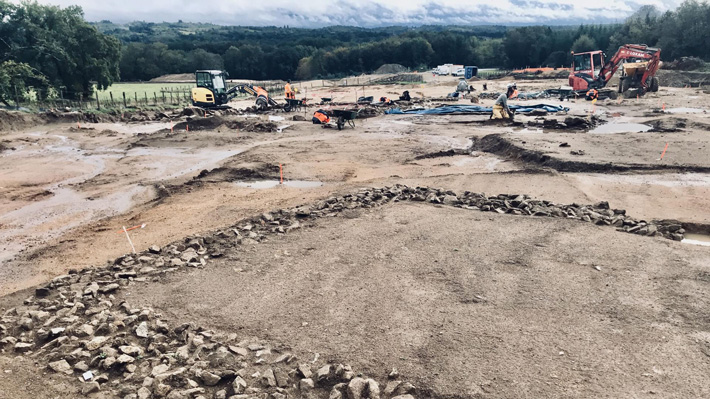
In 2022, Halperin led a team of archaeologists to a temple-pyramid in Ucanal, an archaeological site within the former Maya kingdom. In 800 C.E., the temple’s upper levels would have stood some 150 feet tall. The team excavated various layers of limestone construction blocks until they came upon a burial chamber. While filled with valuable artifacts that signaled royalty—such as a greenstone mask usually buried with rulers—the tomb was arranged unexpectedly

.
Archaeologists found more than   1,500 fragments of objects including greenstone ornaments, pendants and diadems at the burial site. C. Halperin

Unlike the burial sites of other Maya royals, this chamber wasn’t designed for people to enter and share offerings. The remains were buried beneath stone materials typical of facade construction, not places of burial. And the items inside—including surviving fragments of human bones, delicate diadems, stones and pendants—were haphazardly strewn.

Even the ground itself, the team noticed, was infused with odd material. “This soil was so sooty and full of carbon,” Halperin tells Science’s Rodrigo PĂ©rez Ortega. “You couldn’t excavate… you couldn’t be clean.”

Report this ad

It soon became clear to Halperin and the team that these royals and their objects had been exhumed from another site, burned and then dumped here. Because of the setup of the room, they concluded the burning had been an act of desecration rather than reverence.

“The burnt remains were deposited haphazardly and with little care,” Halperin tells Newsweek’s Aristos Georgiou. “Unlike cremation burials placed in urns, no effort was made to protect the remains. Construction fill was thrown on top of it, causing bone and ornament fragments to scatter during the process of its burial.”

They counted at least four adult bodies—three were male, and all were likely related—along with more than 10,000 beads made from ocean shells and some 1,500 pieces of jade, obsidian, plaques and mosaics.

More than 10,000 beads and discs made from marine shells were found at the site. C. Halperin

Radiocarbon dating suggests the blaze was hotter than 1,472 degrees Fahrenheit and was set between the years 773 and 881 C.E. The chamber itself did not have any scorch marks, suggesting the burning occurred elsewhere—either in the rulers’ original tombs or in a public place.

But at the time they were burned, the royals had already been dead for decades, archaeologists found, which led them to hypothesize the burning—which was likely part of a rite called och-i k’ak’ t-u-muk-il, which in the Mayan language means “the fire entered his/her tomb”—was an intentional desecration to celebrate a change in regime.


Scholars have already established that around the time of this fire, the Maya military leader Papmalil was ascending into power. It is possible, the team writes, that setting fire to old royals was a symbolic gesture amid a changing society. Under Papmalil, myriad architectural projects—including new canals, homes and a ball court—were pursued, and new alliances with nearby leaders were forged.

In many ways, the researchers write, the 9th century ruler differed greatly from his predecessors. This discovery offers new evidence of how political changes can be preserved in archaeological records.

“The burning of human remains to erase [the memory of a Maya] dynasty, with all its ornaments—I have not seen that before,” Francisco Estrada-Belli, an archaeologist at Tulane University who was not involved in the new research, tells Science.

“To be able to recognize something like this in the complexity of building fill, instead of it being a formal burial, is a technical achievement in itself,” Thomas Garrison, an archaeologist at the University of Texas who did not participate in the study, tells National Geographic’s Tom Metcalfe. “And I think the argument for it being connected to this specific shift in power is very coherent.”
Mining Watch Romania demands in court suspension of exploitation license for Rosia Montana

Author: Mirea Andreea
Published: 25/04/2024 19:52
Sursa foto: Inquam 
Photos / Ovidiu Dumitru Matiu

The environmental activists of the Mining Watch Romania network request that the judges of the Cluj Court of Appeal suspend the mining license of Rosia Montana Gold Corporation (RMGC), in an effort to definitively stop any possible mining operation in area.

"After the decision of the Washington Court, we should have breathed a sigh of relief that Rosia Montana was saved. It's just that RMGC insists on the request to extend the exploitation license. So, if this license is not suspended by the judges, we risk that the Agency National for Mineral Resources extends it again in June 2024. Extending this license could irreparably damage the valuable Roman, medieval and modern archeological remains of the area and could block any rehabilitation initiative due to the conflict between the mining license and UNESCO regulations," Roxana Pencea Bradasan, from Mining Watch, was quoted as saying in a press release.

Through the filed lawsuit, the members of the Mining Watch network are suing both the RMGC and the National Agency for Mineral Resources (ANRM), requesting the court to suspend the administrative documents for license extension issued in 2019 and to block the current license extension procedures no. 47/1999. The file will have its first trial date on May 9, 2024.

"The Mining Watch network shows, in the notification submitted to the court, that the RMGC license must be suspended for two reasons. First of all, because the administrative acts of extension were 'approved' by an incompetent authority, i.e. ANRM. Lack of a Government Decision of approval implies their non-existence. In fact, the challenged administrative documents never entered into force. Secondly, more than 210 days have passed since the extension documents were issued in 2019, and this is an express reason for revocation, provided for in Law No. 85/2003. The license for Rosia Montana was granted to the state company Minvest in 1999. A year later, it was transferred to the private company Rosia Montana Gold Corporation (formerly Euro Gold Resources). The renewal of this license would perpetuate the illegalities, but also the underdevelopment in which the locality of Apuseni is kept, due to the toxic pressures of the mining company," the organization says.

 Sacred Spring Unearthed Beneath Roman Ruins in France\

Thursday, April 25, 2024

France Chamboret Roman Ruins Neolithic Spring
(© INRAP)

PARIS, FRANCE—According to a Live Science report, near the village of ChamborĂȘt north of the French city of Limoges, archaeologists have uncovered a freshwater spring likely dating to between 4,500 and 6,000 years ago below the remnants of a Roman-era pool. The Roman ruins, which date to the third century A.D., probably formed a landscaped basin surrounded by a wall of granite stones. A team of archaeologists from the French National Institute of Preventive Archaeological Research (INRAP) have also recovered Late Roman pottery sherds, coins, and a ceramic fragment that potentially depicts the face of Medusa or a water deity. Prior to Roman occupation, the earliest evidence of structures at the site includes a rectangular dry-stone building, postholes, sandpits, and what may have been a wood building. Such structures, they believe, were likely part of a home and farm that had been abandoned for several centuries before its revival during the Roman era. An ancient pit found beneath the pool alongside several objects date to the site’s earliest occupation during the Neolithic period. Artifacts from that era include fragments of flint, bricks and tiles singed from a fire, and pieces of a Grand Pressigny dagger—named for another Neolithic site in France. The discoveries, according to the team, offer a glimpse into regional life during Late Antiquity and the transition to the early Middle Ages. For more on the archaeology of Roman Gaul, go to “Off the Grid: Vienne, France.” 

Herculaneum papyri unveil more than location of Plato's tomb in Athens

The papyrus was found in the remains of a luxurious ancient Roman villa with an impressive library in Ancient Herculaneum, in southern Italy's Campania region, which had been buried in the eruption of Mount Vesuvius in 79 A.D. that had also destroyed

"That Plato's tomb was located in his Academy was not something unknown to archaeologists. Diogenes Laertius mentions, in the 3rd century A.D., that Plato was buried at the Academy where he lived for most of his life. So does Pausanius, namely that Plato was, in fact, buried not far from the Academy. What is important is that we have a technology by which people succeeded in reading 1,000 more words than those who had previously read the text on the same papyrus using a different technology," said archaeologist Dr. Kostas Paschalidis, head of the Association of Greek Archaeologists, in statements to the Athens-Macedonian News Agency (ANA) on Wednesday.
"Also, that we may live to learn of hitherto unknown texts from the library of Peisonus - the rich owner of the villa - which will be philosophical because he was chiefly interested in philosophy and especially epicurean [philosophy]," added Paschalidis, in response to the news that there had been a new reading of a papyrus containing the writings of Philodemus the Epicurean, found at the "Villa of the Papyri" at Ercolano in Italy, in what used to be ancient Herculaneum.
"The papyrus appears to say that Plato's grave was near the Temple of the Muses in his Academy. Olympiodorus the Alexandrian, in his commentary on Plato, is reported to say that, upon reaching Athens, Plato founded a school in the Academy and in part of this a temple for the Muses. In reality, the entire Academy is considered a temple of the Muses, a place of learning, so to speak," Paschalidis noted.
For this reason, he added, the archaeologists' association considers that there is a need to protect and supervise every possible project in a zone that has been listed, as is the zone of Akadimia Platonos, that there is a need for staff and that it is hugely significant to respect and provide precautionary protection for such areas.

Deciphered Herculaneum papyrus reveals precise burial place of Plato

Various imaging methods comprised a kind of "bionic eye" to examine charred scroll.


JENNIFER OUELLETTE - 4/25/2024, 

Enlarge / Imaging setup for a charred ancient papyrus recovered from the ruins of Herculaneum; 30 percent of the text has now been deciphered.
CNR – Consiglio Nazionale delle Ricerche56

Historical accounts vary about how the Greek philosopher Plato died: in bed while listening to a young woman playing the flute; at a wedding feast; or peacefully in his sleep. But the few surviving texts from that period indicate that the philosopher was buried somewhere in the garden of the Academy he founded in Athens. The garden was quite large, but archaeologists have now deciphered a charred ancient papyrus scroll recovered from the ruins of Herculaneum, indicating a more precise burial location: in a private area near a sacred shrine to the Muses, according to Constanza Millani, director of the Institute of Heritage Science at Italy's National Research Council.

As previously reported, the ancient Roman resort town Pompeii wasn't the only city destroyed in the catastrophic 79 AD eruption of Mount Vesuvius. Several other cities in the area, including the wealthy enclave of Herculaneum, were fried by clouds of hot gas called pyroclastic pulses and flows. But still, some remnants of Roman wealth survived. One palatial residence in Herculaneum—believed to have once belonged to a man named Piso—contained hundreds of priceless written scrolls made from papyrus, singed into carbon by volcanic gas.

The scrolls stayed buried under volcanic mud until they were excavated in the 1700s from a single room that archaeologists believe held the personal working library of an Epicurean philosopher named Philodemus. There may be even more scrolls still buried on the as-yet-unexcavated lower floors of the villa. The few opened fragments helped scholars identify various Greek philosophical texts, including On Nature by Epicurus and several by Philodemus himself, as well as a handful of Latin works. But the more than 600 rolled-up scrolls were so fragile that it was long believed they would never be readable, since even touching them could cause them to crumble.Advertisement

FURTHER READINGAI helps decipher first text of “unreadable” ancient Herculaneum scroll

Scientists have brought all manner of cutting-edge tools to bear on deciphering badly damaged ancient texts like the Herculaneum scrolls. For instance, in 2019, German scientists used a combination of physics techniques (synchrotron radiation, infrared spectroscopy, and X-ray fluorescence) to virtually "unfold" an ancient Egyptian papyrus.

Brent Seales' lab at the University of Kentucky has been working on deciphering the Herculaneum scrolls for many years. He employs a different method of "virtually unrolling" damaged scrolls, using digital scanning with micro-computed tomography—a noninvasive technique often used for cancer imaging—with segmentation to digitally create pages, augmented with texturing and flattening techniques. Then they developed software (Volume Cartography) to virtually unroll the scroll.

The older Herculaneum scrolls were written with carbon-based ink (charcoal and water), so one would not get the same fluorescing in the CT scans, but the scans can still capture minute textural differences indicating those areas of papyrus that contained ink compared to the blank areas, and it's possible to train an artificial neural network to do just that.


Enlarge / Infrared and X-ray scanners have deciphered more than 1,000 words of Philodemus' History of the Academy text that were previously illegible.
D.P. Pavone

This latest work is under the auspices of the "GreekSchools" project, funded by the European Research Council, which began three years ago and will continue through 2026. This time around, scholars have used infrared, ultraviolet optical imaging, thermal imaging, tomography, and digital optical microscopy as a kind of "bionic eye" to examine Philodemus' History of the Academy scroll, which was also written in carbon-based ink. Nonetheless, they were able to extract over 1,000 words, approximately 30 percent of the scroll's text, revealing new details about Plato's life as well as his place of burial.

Most notably, the historical account of Plato being sold into slavery in his later years after running afoul of the tyrannical Dionysius is usually pegged to around 387 BCE. According to the newly deciphered Philodemus text, however, Plato's enslavement may have occurred as early as 404 BCE or shortly after the death of Socrates in 399 BCE.

"Compared to previous editions, there is now an almost radically changed text, which implies a series of new and concrete facts about various academic philosophers," Graziano Ranocchia, lead researcher on the project, said. "Through the new edition and its contextualization, scholars have arrived at unexpected interdisciplinary deductions for ancient philosophy, Greek biography and literature, and the history of the book.”

Other deciphering efforts are also still underway. For instance, last fall we reported on the use of machine learning to decipher the first letters from a previously unreadable ancient scroll found in an ancient Roman villa at Herculaneum—part of the 2023 Vesuvius Challenge. And earlier this year tech entrepreneur and challenge co-founder Nat Friedman announced via X (formerly Twitter) that they had awarded the grand prize of $700,000 for producing the first readable text.

When the Vesuvius Challenge co-founders started the challenge, they thought there was less than a 30 percent chance of success within the year since, at the time, no one had been able to read actual letters inside of a scroll. However, the crowdsourcing approach proved wildly successful. That said, it's still just 5 percent of a single scroll.

So there is a new challenge for 2024: $100,000 for the first entry that can read 90 percent of the four scrolls scanned thus far. The primary goal is to perfect the auto-segmentation process since doing so manually is both time-consuming and expensive (more than $100 per square centimeter). This will lay the foundation for one day being able to scan and read all 800 scrolls discovered so far, as well as any additional scrolls that are unearthed should the remaining levels of the villa finally be excavated.


JENNIFER OUELLETTEJennifer is a senior reporter at Ars Technica with a particular focus on where science meets culture, covering everything from physics and related interdisciplinary topics to her favorite films and TV series. Jennifer lives in Baltimore with her spouse, physicist Sean M. Carroll, and their two cats, Ariel and Caliban.


Archaeologists try to answer new questions about first humans in Southeast Alaska

underwater archaeology
A team of scientists and Alaska Native community members use an autonomous underwater vehicle to explore the continental shelf west of Prince of Wales Island in southeast Alaska, seeking submerged caves and rock shelters that would have been accessible to early inhabitants of the region. (From NOAA)

A few years ago, a set of 20,000-year-old human footprints in a dry lakebed in New Mexico set scientists reeling. Those fossilized footprints, originally discovered in 2009, called into question what we thought we knew about when people first showed up in North America. Archaeologists thousands of miles away in Alaska felt the scientific impact especially strongly.

recent paper published in the journal Nature attempts to set a new timeframe of when the first humans might have appeared along the coast of Southeast Alaska, using cave remains and animal fossils from the region.

But it’s just one piece of a much bigger puzzle.

The Nature article caught the attention of Nick Schmuck, an archaeologist with the Alaska Department of Natural Resources. He said how and when people showed up in Alaska and the Americas is a debate that may never be settled in the scientific community.

“It doesn’t take long getting into the literature on this topic to realize that this is really a heated debate,” Schmuck said. “You’ve got folks who are diehards for one idea. You can think about it as paradigms, you know, we all think about a topic in a certain way for a while.”

According to Schmuck, there are many theories in this debate but currently, the most commonly held belief is in the Coastal Migration Theory.

Remember learning about the Bering land bridge in middle school? That’s part of the Coastal Migration Theory, which suggests that after the last Ice Age, early humans migrating from Asia crossed the land bridge between Russia and Alaska in search of food. Then they traveled, either by foot or by boat, down along the coast of Alaska and into the rest of the Americas.

“These people coming into the Americas – doesn’t matter how far back we go – they’re just as capable as you and I. So, they can figure out how to use boats. They were no strangers to rivers and things like that, so, why not the coast?” Schmuck said.

For his own part, Schmuck is a bit of a pluralist. He believes this is one of many potential routes early humans took. 

The recent Nature article, “New age constraints for human entry into the Americas on the north Pacific coast” by Martina Steffen, attempts to tighten the parameters of the coastal migration debate. The paper looks at gaps in dates of animal fossils and archaeological sites, including 18 caves and sites in Southeast Alaska.

During the iciest part of the last Ice Age, a massive ice sheet advanced across the western part of the continent and over Prince of Wales Island, the largest island in Southeast. All of that now dry land, buried under thousands of tons of ice. Archaeologists believe that at its peak — known as the “glacial maximum” — about 18,000 years ago, that giant wall of ice would have blocked off any land routes down the coastline. Think of it like a gate that closed for over 1,000 years. 

So, the commonly held belief is that people showed up after that, as the glaciers melted from the outside in, revealing land and food to eat.

For Schmuck, it isn’t just the fossil record that supports this post-glacial theory, it’s the spoken record of the descendants of these first people. 

“They sound like people coming to an early post-glacial Southeast Alaska,” Schmuck said, describing oral histories. “They talk about coming to a land that’s just a narrow strip of land between the ice and the sea. Like, holy cow! That’s what Southeast Alaska would have been before the trees came in.”

“I think the important thing to remember is that we know that we have been here for at least 12,000 years. We know that from DNA science,” said KaahĂĄni Rosita Worl, a Lingit anthropologist and president of the Sealaska Heritage Institute. 

Worl is a descendant of those first people.

“To me, it affirms our oral traditions that say we’ve been here since time immemorial,” she said.

If the carbon dating was done correctly, and most archaeologists now agree it was, the New Mexico footprints are much older than the signs of human life found in Southeast Alaska. That means the footprints were from someone who was in North America before those giant ice sheets sealed the land shut, which, in turn, means that either the humans that left the New Mexico footprints didn’t cross the Bering land bridge at all or people were here much earlier than Western scientists had thought.

“There had to be another route,” said Worl. “And the coastal route – it opens up and you have resources available that people could live on.”

The footprints changed everything, according to Bryn Letham, an archaeologist at Simon Fraser University in Vancouver. And of course, he says, there were skeptics. Some made a plausible argument that the carbon-dating was wrong. But as time went on, that didn’t seem to be the case. The White Sands team kept testing the fossils and every time got the same result: that footprint was from someone 21,000-23,000 years ago.

In a 2024 article for PaleoAmerica, Letham wrote that it was breathtaking, but it also raised an existential question for him and his colleagues: “What have we been spending our careers doing?”

Had they been searching in the wrong places? The wrong times?

The footprints in New Mexico started a race among those studying the Pacific Northwest coast. Most of the geologists and archaeologists are united by a common goal — to find the oldest sites of human occupation.

Currently, the earliest signs of life in Southeast Alaska is ShukĂĄ KĂĄa – a human skeleton and set of tools from about 10,300 years ago in a cave on Prince of Wales Island.

It’s possible archaeologists just haven’t found older evidence yet, because of the challenges of searching in the forest-covered region.

“I mean, you’ve been in the Tongass, it’s big trees. It’s hard to see very far ahead of you and it’s hard to imagine what the landscape looked like,” said Nick Schmuck, adding though that the technology is improving. Specifically, a method called LiDAR that can map the earth’s topography using pulsed lasers.

“It takes all the trees off and gives you a new map based on the surface. All of the sudden, beach terraces pop out like you wouldn’t believe. And you can just look at the image and say, ‘Oh, there’s an ancient shoreline right here.’ And you can hike right to it. And boom, there’s your 10,000 year old beach with a 10,000 year old site on it.”

Another factor in Southeast Alaska is what one scientist refers to as almost a tectonic seesaw effect. During that glacial maximum, the massive ice sheet that covered the mainland was so heavy that it literally pushed the land down. That caused the outlying islands and land masses further off the mainland to rise up above sea level, like a seesaw.

What this means for Southeast Alaska is that a lot of the oldest evidence of humans is probably either at the top of a mountain or the bottom of the ocean — which is where Kelly Monteleone, an underwater archaeologist with Sealaska Heritage Institute, comes in.

“There’s this huge, vast area that we haven’t explored yet. And so there’s so much we can find,” Monteleone said.

According to Monetleone, her profession is pretty much the same thing as a regular archaeologist. It just involves some extra work.

“Nothing changes between the terrestrial answer and the underwater answer, we just have a much more complicated step every step of the way,” she laughed.

What Monetleone and her team have found on the seafloor, including a fish weir that would have been at sea level more than 10,000 years ago, changes the “when” of coastal migration.

“I see myself as having the resources to help answer the questions of the Indigenous people of Southeast Alaska. So I have the skills as an underwater archaeologist to go out and look in areas to help them learn about their past,” she said.

As Bryn Letham put it, the current people of the coastal First Nations are the descendants of those first post-glacial humans.

Schmuck agreed, saying that in Southeast Alaska, “we’re talking about the ancestors of people who’ve been here for a really long time.”

He acknowledged that archaeology as a profession hasn’t always been a positive force in that regard.

“We don’t want to get too abstract about the people in the past,” he said. “We don’t want to get back into the old faults of archaeology, where we’re just looking at rocks and forgetting to think about people. These are people’s ancestors.”

Letham, Worl, Schmuck, and Monteleone all point out that the Indigenous peoples along the Northwest Coast are strikingly diverse. There are so many languages and cultures in such a condensed area and they are so isolatedly different from each other that it seems like people would’ve had to have been here a lot longer than other parts of the Americas. In other words, it takes a lot of long, sustained time in one place for entire languages and cultures to develop.

On the northwest Pacific coast, there are dozens in close proximity, each distinctly different from the next, which tells anthropologists that people got to Southeast Alaska after the last Ice Age and stayed, splintering off into tribes and isolate cultures over many thousands of uninterrupted years. 

These origins are older than people can generally comprehend, predating known forms of agricultural civilization.

“The concept of time at 12,000 years is not a concept that humans can usually digest,” said Moneteleone. “Time immemorial, the beginning of time: 12,000 years ago, 16,000, 20,000 years ago – those are all the beginning of time.”

And while the rest of the world chases after New Mexico’s footprints, Monteleone says that understanding the history of the people of the Northwest Coast is an archaeological field of study that is still in its infancy.

Get in touch with the author at jack@krbd.org.

Metal Detectorists Unearth Tiny Bronze Portrait of Alexander the Great in Denmark

Researchers think the 1,800-year-old artifact could be linked to a Roman emperor who was “obsessed” with the Macedonian conqueror


Julia Binswanger
Daily Correspondent
SMITHSONIAN
April 25, 2024 
The newly discovered bronze disc depicts Alexander the Great with wavy hair and ram horns. M. Petersen, Museum VestsjĂŠlland

A one-inch bronze portrait of Alexander the Great dating to around 200 C.E. has been unearthed on an island in Denmark.

Two metal detectorists, Finn Ibsen and Lars Danielsen, were searching a field outside of Ringsted, a city on the island of Zealand, when Ibsen came across the unusual object.

“I stand and jump on the spot and … wave Lars over,” Ibsen recalls to Kristoffer Koch of the Danish news outlet TV2 Øst, per Google Translate. “He comes running, and we can see that it is unique. It is a face.”

The friends handed the portrait over to Denmark’s Museum West Zealand. Archaeologists aren’t certain about the small disc’s function, but they say it could have been a decoration attached to a shield or sword belt.

Freerk Oldenburger, an archaeologist at the museum, tells Live Science’s Jennifer Nalewicki that the disc is “almost identical” to a silver artifact found several years ago in Jutland, Denmark.

“It’s quite a remarkable piece,” he says. “When it showed up on my desk, I nearly fell out of my chair because it’s almost the exact same portrait as the other, but this one is a little more coarse and is made of cast bronze and not gilded silver.”

Oldenburger called the metal detectorists and explained what he’d pieced together. Ibsen was thrilled to hear more about his discovery. As he tells TV2 Øst, “Being taken 2,000 years back in time gives a huge rush.”

Alexander the Great was an ancient Macedonian king who ruled in the fourth century B.C.E. His empire was one of the largest in the ancient world, spanning multiple continents and stretching from Greece and Egypt to India. According to a statement from Museum West Zealand, researchers recognized the ruler’s visage from the figure’s signature wavy hair and decorative crown of twisted ram horns.

The metal disc was made some 500 years after Alexander’s reign, and researchers speculate that it may be linked to the Roman Empire. According to the museum, Alexander was a “great role model” for Roman leaders—and a particularly influential figure for the emperor Caracalla, who reigned from 198 to 217 C.E.

The disc dates to “around the same time as Caracalla,” Oldenburger tells Live Science. “We know that he was completely obsessed with Alexander the Great and was interested and inspired by him, since he was the greatest conqueror of that time period.”

Caracalla was so consumed with him that he even “dressed with the same style and believed he was Alexander the Great reincarnated,” Oldenburger adds. “Caracalla is also the only emperor of his time to be depicted with a shield containing a portrait of Alexander the Great.”

If the disc is connected to ancient Rome, how did it travel all the way to Denmark? Researchers aren’t sure, but they note that trade routes likely connected the two societies.

“[The bronze disk] shows that even the smallest archaeological objects can hide absolutely incredible stories,” says Oldenburger in the statement. “This is a unique find in Scandinavia with connections to one of the most famous personalities in world history.”

 Teotihuacan's Pyramids Damaged By Ancient Earthquakes

Thursday, April 25, 2024

Teotihuacan Feathered Serpent Temple
(PĂ©rez-LĂłpez et al. 2024, Journal of Archaeological Science: Reports)


MADRID, SPAIN—A new study of pyramids at the ancient city of Teotihuacan by a team of Spanish geologists has documented damage to the structures caused by five devastating megathrust earthquakes that hit the site between about A.D. 100 and 600, Live Science reports. At its height, the population of Teotihuacan, which is located northeast of Mexico City, reached some 100,000 residents. Megathrust earthquakes occur at subduction zones of tectonic plates, and though they tend to happen more infrequently than other seismic events, their magnitude is much greater. The researchers recorded the effects of immense ground shaking on the Temple of the Feathered Serpent, the Pyramid of the Sun, and the Pyramid of the Moon. The structural damage included fracturing and dislodging of large masonry blocks used to construct the buildings, as well as chipping of blocks that comprised the pyramids' outer stairs. "The initial response by the Teotihuacanos was to reinforce the Sun Pyramid, the largest structure in their city, along its north-south axis in an attempt to fortify it against future earthquakes," said geologist RaĂșl PĂ©rez-LĂłpez of the Geological and Mining Institute of Spain. "Additionally, they repurposed and removed other elements damaged by seismic activity. Interestingly, they opted to conceal one of the most conspicuous signs of earthquake damage: the rotation and displacement of the west staircase of the Temple of the Feathered Serpent." Despite these efforts, he said, the earthquakes were likely a contributing factor to the city's precipitous population decline and later abandonment at the end of the seventh century. "The disruption caused by a devastating earthquake not only shakes the physical foundations of a society but also destabilizes its social and political structures," PĂ©rez-LĂłpez concluded. "This creates fertile ground for unrest, potentially sparking rebellions fueled by neighboring cities and exacerbating existing tensions." Read the original scholarly article about this research in Journal of Archaeological Science: Reports. To read about liquid mercury found beneath the Feathered Serpent Pyramid, go to "Mythological Mercury Pool," one of ARCHAEOLOGY's Top 10 Discoveries of 2015.

 Rare Turtle Statue Found in Angkor

Thursday, April 25, 2024

Cambodia Turtle Sculpture
(Cambodian Heritage Protection Police)

SIEM REAP, CAMBODIA—A rare sandstone sculpture of a turtle has been found at Bayon Temple in the Angkor Archaeological Park in Siem Reap, according to a report in The Phnom Penh Post. The Bayon temple was built in the late twelfth and early thirteenth century A.D. during the reign of the Khmer ruler Jayavarman VII (reigned 1181–1220) and is best known for the many enormous carved faces of the Buddha that adorn its highly decorated exterior. The sculpture was found beneath a previously unknown pond by archaeologists from the Apsara National Authority (ANA), which oversees the park. “While many believed there was nothing left to find, our archaeological research has uncovered evidence that Bayon Temple actually boasted two ponds on its eastern side,” says ANA spokesperson Long Kosal. “This necessitates a reassessment of the historical significance of these sites.” Bayon Temple is just one of hundreds of structures built by the Khmer rulers from the ninth to fifteenth century, including Angkor Wat and Angkor Thom, that are now inside the 155-square-mile park. To read about a lidar survey of 900 square miles of the greater Angkor region, go to "Angkor Urban Sprawl," one of ARCHAEOLOGY's Top 10 Discoveries of 2017.

New rock art discoveries in Eastern Sudan tell a tale of ancient cattle, the ‘green Sahara’ and climate catastrophe


THE CONVERSQTION
Published: April 25, 2024 4.02pm EDT

The hyper-arid desert of Eastern Sudan, the Atbai Desert, seems like an unlikely place to find evidence of ancient cattle herders. But in this dry environment, my new research has found rock art over 4,000 years old that depicts cattle.

In 2018 and 2019, I led a team of archaeologists on the Atbai Survey Project. We discovered 16 new rock art sites east of the Sudanese city of Wadi Halfa, in one of the most desolate parts of the Sahara. This area receives almost no yearly rainfall.

Almost all of these rock art sites had one feature in common: the depiction of cattle, either as a lone cow or part of a larger herd.

On face value, this is a puzzling creature to find carved on desert rock walls. Cattle need plenty of water and acres of pasture, and would quickly perish today in such a sand-choked environment.

Written by academics, edited by journalists, backed by evidence.Get newsletter

In modern Sudan, cattle only occur about 600 kilometres to the south, where the northernmost latitudes of the African monsoon create ephemeral summer grasslands suitable for cattle herding.

The theme of cattle in ancient rock art is one of most important pieces of evidence establishing a bygone age of the “green Sahara”.
New sites discovered on surveys in Eastern Sudan. © The Atbai Survey Project
The ‘green Sahara’

Archaeological and climatic fieldwork across the entire Sahara, from Morocco to Sudan and everywhere in between, has illustrated a comprehensive picture of a region that used to be much wetter.

Climate scientists, archaeologists and geologists call this the “African humid period”. It was a time of increased summer monsoon rainfall across the continent, which began about 15,000 years ago and ended roughly 5,000 years ago.


The wastes of the Atbai Desert, north-east Sudan – a very different landscape to the ‘green Sahara’. Julien Cooper

This “green Sahara” is a vital period in human history. In North Africa, this was when agriculture began and livestock were domesticated.

In this small “wet gap”, around 8,000–7,000 years ago, local nomads adopted cattle and other livestock such as sheep and goats from their neighbours to the north in Egypt and the Middle East.

Read more: The Sahara Desert used to be a green savannah – new research explains why
A close human-animal connection

When the prehistoric artists painted cattle on their rock canvasses in what is now Sudan, the desert was a grassy savannah. It was brimming with pools, rivers, swamps and waterholes and typical African game such as elephants, rhinos and cheetah – very different to the deserts of today.

Cattle were not just a source of meat and milk. Close inspection of the rock art and in the archaeological record reveals these animals were modified by their owners. Horns were deformed, skin decorated and artificial folds fashioned on their neck, so-called “pendants”
.
A strong relationship between human and animal: a cow with a modified ‘neck’ pendant and horns. Julien Cooper

Cattle were even buried alongside humans in massive cemeteries, signalling an intimate link between person, animal and group identity.
The perils of climate change

At the end of the “humid period”, around 3000 BCE, things began to worsen rapidly. Lakes and rivers dried up and sands swallowed dead pastures. Scientists debate how rapidly conditions worsened, and this seems to have differed greatly across specific subregions.

Local human populations had a choice – leave the desert or adapt to their new dry norms. For those that left the Sahara for wetter parts, the best refuge was the Nile. It is no accident that this rough period also eventuated in the rise of urban agricultural civilisations in Egypt and Sudan.


The most common image in the local rock art was of cattle. Julien Cooper

Some of the deserts, such as the Atbai Desert around Wadi Halfa where the rock art was discovered, became almost depopulated. Not even the hardiest of livestock could survive in such regions. For those who remained, cattle were abandoned for hardier sheep and goats (the camel would not be domesticated in North Africa for another 2,000–3,000 years).

This abandonment would have major ramifications on all aspects of human life: diet and lack of milk, migratory patterns of herding families and, for nomads so connected to their cattle, their very identity and ideology.
New phases of history

Archaeologists, who spend so much time on the ancient artefacts of the past, often forget our ancestors had emotions. They lived, loved and suffered just like we do. Abandoning an animal that was very much a core part of their identity, and with whom they shared an emotional connection, cannot have been easy for their emotions and sense of place in the world.

For those communities that migrated and lived on the Nile, cattle continued to be a symbol of identity and importance. At the ancient capital of Sudan, Kerma, community leaders were buried in elaborate graves girded by cattle skulls. One burial even had 4,899 skulls.

Today in South Sudan and much of the Horn of Africa, similar practices regarding cattle and their cultural prominence endure to the present. Here, just as in ancient Sahara, cattle are decorated, branded and have an important place in funeral traditions, with cattle skulls marking graves and cattle consumed in feasts.

As we move into a new phase of human history subject to rapid climate oscillations and environmental degradation, we need to ponder just how we will adapt beyond questions of economy and subsistence.

One of the most basic common denominators of culture is our relationship to our shared landscape. Environmental change, whether we like it or not, will force us to create new identities, symbols and meanings.

Read more: Innovations on the Nile over millennia offer lessons in engineering sustainable futures


Author
Julien Cooper
Honorary Lecturer, Department of History and Archaeology, Macquarie University
Disclosure statement
Julien Cooper receives funding from the Australian Research Council and Macquarie University.

Plattsburgh discusses raising Revolutionary War ship ‘Spitfire’ out of Lake Champlain

By Alek LaShomb
Published: Apr. 25, 2024

PLATTSBURGH, N.Y. (WCAX) - Talks continue over raising the “Spitfire,” a gunboat under Benedict Arnold’s command during the Battle of Valcour Island in 1776.

Underwater archaeologist Art Cohn was on the team in 1997 that discovered the boat’s location at the bottom of Lake Champlain. Back in 2017, the idea of raising the ship was floated around and now he says those talks are ramping up.

“I have been doing this work for over 40 years, I have never recommended a boat be recovered until now. We have identified four studies we are ready to do, four contracts to do our due diligence,” said Cohn.

He says the studies include engineering, a business plan, conservation for when the boat is removed from the lake, and a look at an exhibition facility for a permanent display. All four studies, he says, are primed and ready for funding. But first, he says researchers want to take another dive into the lake to inspect the American treasure.

”We have just applied for a permit to inspect the boat again this year, film it, and determine what the state of the mussels are,” said Cohn.

He says it would take another 15 years to raise the ship and more than $40 million stretched out over time. Cohn also reaffirms his belief that the ship should remain in the North Country where it was built and faced battle, something Plattsburgh Mayor Chris Rosenquest says would be a big boost for the area.

“It is a major attraction and whenever we have new things like this, it will be a boost to the local economy and attract more tourists here,” said Rosenquest.

Cohn says it would keep the past alive for posterity. “It would be our legacy for preserving that, the foundation days of this country, and I think that would be a great thing to do,” he said.

Copyright 2024 WCAX. All rights reserved.