Wednesday, October 07, 2020


A factor limiting recovery from bleaching in corals


by National Institutes of Natural Sciences
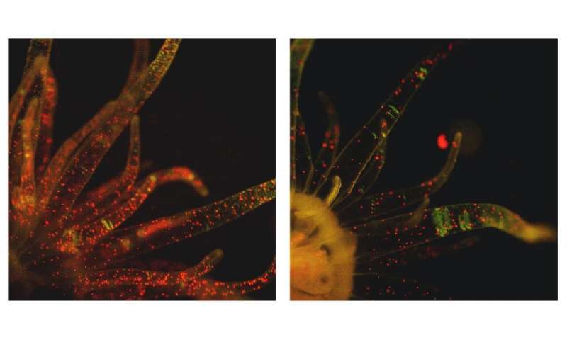
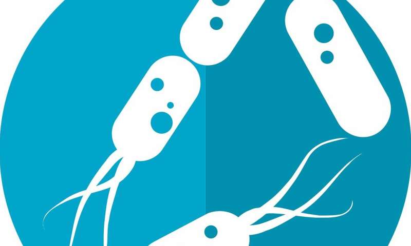
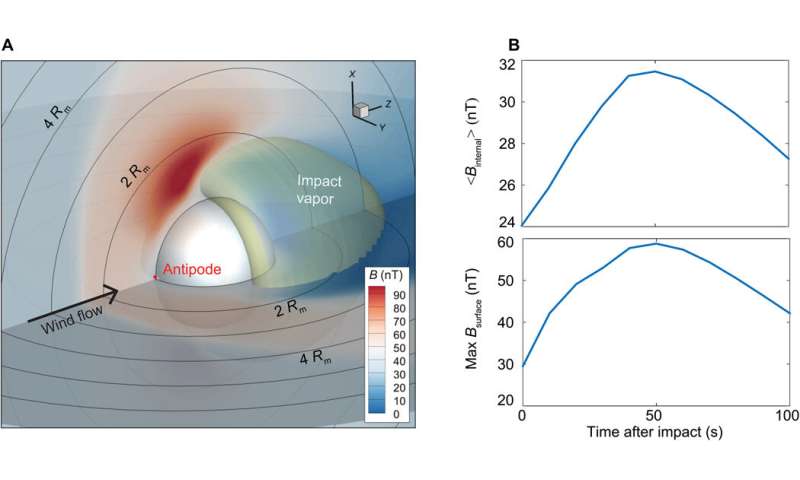
Fluorescent photographs of Aiptasia polyps 3 days after culturing with symbiont cells in different treatments, neither symbionts nor polyps exposed to high temperature (32?°C) for 3 days (left), only symbionts exposed to high temperature (right). Credit: NIBB

Increases in seawater temperature can cause coral bleaching through the loss of symbiotic algae. Corals can recover from bleaching by recruiting algae into host cells from the residual symbiont population or from the external environment. However, the high coral mortality that often follows mass-bleaching events suggests that recovery is limited in the wild.


A joint research team from the National Institute for Basic Biology (NIBB), Tohoku University in Japan, and James Cook University in Australia has examined the effect of pre-exposure to heat stress on the capacity of symbiotic algae to infect cnidarian hosts using the Aiptasia (sea-anemone)-zooxanthellae (algae) model system. They discovered that the symbiotic algae lose their capacity to infect the host once they are exposed to heat stress. These results suggest that recovery from bleaching can be limited by the loss of symbiont infectivity following bleaching-inducing heat stress.

Coral reefs are the cornerstone of biologically enriched coral reef ecosystems, but their existence is in danger due to global change and warming. Coral-algae symbiosis is sensitive to increased seawater temperature, resulting in coral bleaching through loss of the algal symbionts, zooxanthellae. Corals can recover from bleaching by recruiting algae into their cells from the residual symbiont population or from the external environment. However, in the field, recovery from bleaching is often limited, resulting in mortality of corals due to starvation.

In a study published in The ISME Journal, graduate student of the National Institute for Basic Biology, Mariko Kishimoto, focused on the ability of symbiotic algae to infect the host following to heat stress and identified a factor limiting recovery from bleaching.

"In this study, we used Aiptasia (sea-anemone), instead of corals, as Aiptasia are very easy to maintain and use for experiments in the laboratory. And importantly, Aiptasia form the symbiotic relationship with the symbiotic algae, zooxanthellae, and also show bleaching under heat stress like corals do." Ms. Kishimoto said.

Symbiotic algae (CS-164) were cultured at 25 ºC or 32 ºC for 3 days and then their infectivity was tested at 25 ºC by counting the number of symbiotic algae in Aiptasia tentacles.

"The infectivity of algae was apparently lost after culturing at 32 ºC."

"Importantly, culturing Aiptasia, instead of algae, at 32 ºC did not influence infectivity."

"So our results showed that recovery from bleaching can be limited by the loss of symbiont infectivity following bleaching-inducing heat stress.", Ms. Kishimoto said.

Further study showed incubation at 32 ºC was non-lethal for the symbiotic algae which showed recovery of the loss of infectivity after culturing at optimal growth conditions.

The team also found that a different algal strain (CCMP2459) did not lose their infectivity after exposure to heat stress.

Associate Professor Shunichi Takahashi of the National Institute for Basic Biology, who led the research team, said, "Our findings suggest that heat tolerant algal symbionts might give a chance for bleached corals to recover".


Explore further Who controls whom: Algae or sea anemone?

More information: Mariko Kishimoto et al, Loss of symbiont infectivity following thermal stress can be a factor limiting recovery from bleaching in cnidarians, The ISME Journal (2020). DOI: 10.1038/s41396-020-00742-8 

Journal information: ISME Journal

Provided by National Institutes of Natural Sciences
Could a poo transplant one day be the secret of eternal youth?

by University of East Anglia
Credit: CC0 Public Domain

Fecal transplants could one day be used as a therapy to restore cognitive function in the elderly—according to new research from the University of East Anglia, the University of Florence and the Quadram Institute.

A new study published today shows how fecal transplants from older to younger mice altered their gut microbiome, which in turn impacted their spatial learning and memory.

The research team hope that reversing the procedure could one day see fecal transplantation used to combat cognitive decline among the elderly.

Dr. David Vauzour, from UEA's Norwich Medical School, said: "Aging is an inevitable process that starts immediately after birth and ultimately leads to physical health problems as well as a decline in psychological well-being and cognitive function.

"Research has shown that the aging process may be linked with age-related changes in our gut microbiota. Recently, the existence of two-way communication between the gut and the brain—known as the 'gut-brain axis' – has emerged as an important player in shaping aspects of behavior and cognitive function. We wanted to see whether transferring gut microbes from older to younger mice could affect parts of the central nervous system associated with aging."

The research team performed fecal transplants from older adult mice to younger adult mice and then assessed the young adults for markers such as anxiety, exploratory behavior and memory.

After the transplantation, the team found significant differences in the young mice's microbial profiles.

While the young adults showed no significant changes in markers of anxiety, explorative behavior or locomotor activity, they did show impaired spatial learning and memory as measured in a maze test.

These changes were paralleled by alterations in the expression of proteins associated with synaptic plasticity and neuro transmission, and changes to cells in the hippocampus part of their brains—responsible for learning and memory.

Dr. Vauzour said: "Our research shows that a fecal transplantation from an old donor to a young recipient causes an age-associated shift in the composition of gut microbiota. The procedure had an impact on the expression of proteins involved in key functions of the hippocampus—an important part of the brain that has a vital role in a variety of functions including memory, learning but also in spatial navigation and emotional behavior and mood. In short, the young mice began to behave like older mice, in terms of their cognitive function."


Prof Claudio Nicoletti, from the University of Florence, Italy, said: "While it remains to be seen whether transplantation from very young donors can restore cognitive function in aged recipients, the findings demonstrate that age-related shifts in the gut microbiome can alter components of the central nervous system." This work highlights the importance of the gut-brain axis in aging and provides a strong rationale to devise therapies aiming to restore a young-like microbiota to improve cognitive functions and quality of life in the elderly, he added.

"Manipulating the microbiome is increasingly being seen as a way of improving or maintaining human health, and these results are an exciting indication of its potential for helping us age healthily," said Prof Arjan Narbad from the Quadram Institute.

"We have established an FMT service on the Norwich Research Park to treat serious gut infections and now want to explore in humans its effectiveness in combating a number of age-related conditions, including cognitive decline."

The research was led by a team at UEA and the University of Florence, in collaboration with colleagues at the University of Milan, the Earlham Institute, University of Siena, the Quadram Institute, and Nottingham Trent University.

It was funded by the Fondazione Cassa di Risparmio, the University of Florence and the Medical Research Council.

"Fecal microbiota transplant from aged donor mice affects spatial learning and memory via modulating hippocampal synaptic plasticity- and neurotransmission-related proteins in young recipients" is published in the journal Microbiome.

Study finds gut microbiome plays important role in sleep regulation
More information: Alfonsina D'Amato et al. Fecal microbiota transplant from aged donor mice affects spatial learning and memory via modulating hippocampal synaptic plasticity- and neurotransmission-related proteins in young recipients, Microbiome (2020). 

Past tropical forest changes drove megafauna and hominin extinctions


by Max Planck Society
Artist's reconstruction of a savannah in Middle Pleistocene Southeast Asia. In the foreground Homo erectus, stegodon, hyenas, and Asian rhinos are depicted. Water buffalo can be seen at the edge of a riparian forest in the background Credit: Peter Schouten

In a paper published today in the journal Nature, scientists from the Department of Archaeology at MPI-SHH in Germany and Griffith University's Australian Research Centre for Human Evolution have found that the loss of southeast Asian grasslands was instrumental in the extinction of many of the region's megafauna, and probably of ancient humans too.


"Southeast Asia is often overlooked in global discussions of megafauna extinctions," says Associate Professor Julien Louys, who led the study, "But in fact, it once had a much richer mammal community full of giants that are now all extinct."

By looking at stable isotope records in modern and fossil mammal teeth, the researchers were able to reconstruct whether past animals predominately ate tropical grasses or leaves, as well as the climatic conditions at the time they were alive. "These types of analyses provide us with unique and unparalleled snapshots into the diets of these species and the environments in which they roamed," says Dr. Patrick Roberts of the MPI-SHH, the other corresponding author of this study.

The researchers compiled these isotope data for fossil sites spanning the Pleistocene, the last 2.6 million years, as well as adding over 250 new measurements of modern Southeast Asian mammals representing species that had never before been studied in this way.

They showed that rainforests dominated the area from present-day Myanmar to Indonesia during the early part of the Pleistocene but began to give way to more grassland environments. These peaked around 1 million years ago, supporting rich communities of grazing megafauna such as the elephant-like stegodon that, in turn, allowed our closest hominin relatives to thrive. But while this drastic change in ecosystems was a boon to some species, it also lead to the extinction of other animals, such as the largest ape ever to roam the planet: gigantopithecus.
A collection of mammal skulls of species endemic to Southeast Asia. Credit: Julien Louys

However, as we know today, this change was not permanent. The tropical canopies began to return around 100,000 years ago, alongside the classic rainforest fauna that are the ecological stars of the region today.

The loss of many ancient southeast Asian megafauna was found to be correlated with the loss of these savannah environments. Likewise, ancient human species that were once found in the region, such as Homo erectus, were unable to adapt to the re-expansion of forests.

"It is only our species, Homo sapiens, that appears to have had the required skills to successfully exploit and thrive in rainforest environments," says Roberts. "All other hominin species were apparently unable to adapt to these dynamic, extreme environments."
Modern day rainforest in Southeast Asia. Credit: Julien Louys

Ironically, it is now rainforest megafauna that are most at risk of extinction, with many of the last remaining species critically endangered throughout the region as a result of the activities of the one surviving hominin in this tropical part of the world.

"Rather than benefitting from the expansion of rainforests over the last few thousand years, Southeast Asian mammals are under unprecedented threat from the actions of humans," says Louys. "By taking over vast tracts of rainforest through urban expansion, deforestation and overhunting, we're at risk of losing some of the last megafauna still walking the Earth."


Explore further  Seeking ancient rainforests through modern mammal diets

More information: Environmental drivers of megafauna and hominin extinction in Southeast Asia, Nature (2020). DOI: 10.1038/s41586-020-2810-y

Journal information: Nature


Provided by Max Planck Society
#FRACKQUAKE
Unusually shallow earthquake ruptures in Chinese fracking field

by Seismological Society of America
Credit: Unsplash/CC0 Public Domain

An unusually shallow earthquake triggered by hydraulic fracturing in a Chinese shale gas field could change how experts view the risks of fracking for faults that lie very near the Earth's surface.

In the journal Seismological Research Letters, Hongfeng Yang of The Chinese University of Hong Kong and colleagues suggest that the magnitude 4.9 earthquake that struck Rongxian County, Sichuan, China on 25 February 2019 took place along a fault about one kilometer (0.6 miles) deep.

The earthquake, along with two foreshocks with magnitudes larger than 4, appear to be related to activity at nearby hydraulic fracturing wells. Although earthquakes induced by human activity such as fracking are typically more shallow than natural earthquakes, it is rare for any earthquake of this size to take place at such a shallow depth.

"Earthquakes with much smaller magnitudes, for example magnitude 2, have been reported at such shallow depths. They are understood by having small scale fractures in such depths that can slip fast," said Yang. "However, the dimensions of earthquakes are scale-dependent. Magnitude 4 is way bigger than magnitude 2 in term of rupture length and width, and thus needs a sizeable fault as the host."

"The results here certainly changed our view in that a shallow fault can indeed slip seismically," he added. "Therefore, we should reconsider our strategies of evaluating seismic risk for shallow faults."

Two people died and twelve were injured in the 25 February earthquake, and the economic loss due to the event has been estimated at 14 million RMB, or about $2 million. There have been few historic earthquakes in the region, and before 2019 there had been no earthquakes larger than magnitude 3 on the fault where the main earthquake took place.

Since 2018, there have been at least 48 horizontal fracking wells drilled from 13 well pads in the region, with three well pads less than two kilometers (1.2 miles) from the Molin fault, where the main earthquake took place.

Yang and his colleagues located the earthquakes and were able to calculate the length of the main rupture using local and regional seismic network data, as well as InSAR satellite data.

It is unusual to see clear satellite data for a small earthquake like this, Yang said. "InSAR data are critical to determine the depth and accurate location of the mainshock, because the ground deformation was clearly captured by satellite images," he noted. "Given the relatively small size of the mainshock, it would not be able to cause deformation above the 'noise' level of satellite data if it were deeper than about two kilometers."

The two foreshocks took place on a previously unmapped fault in the area, the researchers found, underscoring how difficult it can be to prevent fracking-induced earthquakes in an area where fault mapping is incomplete.

The researchers note that the Molin fault is separated from the geologic formation where fracking took place by a layer of shale about 800 meters (2625 feet) thick. The separating layer sealed off the fault from fracking fluids, so it is unlikely that the pressures of fluid injected into rock pores around the fault caused the fault to slip. Instead, Yang and colleagues suggest that changes in elastic stress in rock may have triggered the main earthquake on the Molin fault, which was presumed to be stable.

"The results here certainly pose a significant concern: we cannot ignore a shallow fault that was commonly thought to be aseismic," Yang said, who said more public information on fracking injection volume, rate and duration could help calculate safe distances for well placement in the future.


Explore further
The Le Teil earthquake provides new insights on seismic risk in France and Western Europe
More information: Hongfeng Yang et al, A Shallow Shock: The 25 February 2019 ML 4.9 Earthquake in the Weiyuan Shale Gas Field in Sichuan, China, Seismological Research Letters (2020). DOI: 10.1785/0220200202

Paleontologists identify new species of mosasaur


by Michael Brown, University of Alberta
Artist's rendering of Gavialimimus almaghribensis, a newly discovered species of mosasaur that ruled the seas of what is now Morocco some 72 to 66 million years ago. Credit: Tatsuya Shinmura

A new species of an ancient marine reptile evolved to strike terror into the hearts of the normally safe, fast-swimming fish has been identified by a team of University of Alberta researchers, shedding light on what it took to survive in highly competitive ecosystems.

Gavialimimus almaghribensis, a new type of mosasaur, was cataloged and named by an international research team led by master's student Catie Strong, who performed the research a year ago as part of an undergrad honors thesis guided by vertebrate paleontologist Michael Caldwell, professor in the Faculty of Science, along with collaborators from the University of Cincinnati and Flinders University.

More than a dozen types of mosasaur—which can reach 17 meters in length and resemble an overgrown komodo dragon—ruled over the marine environment in what is now Morocco at the tail end of the Late Cretaceous period between 72 and 66 million years ago.

What differentiates Strong's version, however, is that it features a long, narrow snout and interlocking teeth—similar to the crocodilian gharials, a relative of crocodiles and alligators.

Strong said this discovery adds a layer of clarity to a diverse picture seemingly overcrowded with mega-predators all competing for food, space and resources.

"Its long snout reflects that this mosasaur was likely adapted to a specific form of predation, or niche partitioning, within this larger ecosystem."

Strong explained there is evidence that each species of the giant marine lizard shows adaptations for different prey items or styles of predation.
The fossilized skull of the newly identified mosasaur features a long, narrow snout and interlocking teeth, which suggest it adapted to hunt particular prey in a highly competitive ecosystem. Credit: University of Alberta

"For some species, these adaptations can be very prominent, such as the extremely long snout and the interlocking teeth in Gavialimimus, which we hypothesized as helping it to catch rapidly moving prey," she said.

She added another distinctive species would be Globidens simplex—described last year by the Caldwell lab—which has stout, globular teeth adapted for crushing hard prey like shelled animals.

"Not all of the adaptations in these dozen or so species are this dramatic, and in some cases there may have been some overlap in prey items, but overall there is evidence that there's been diversification of these species into different niches," Strong noted.

Alternatively, the main contrasting hypothesis would be a scenario of more direct competition among species. Strong said given the anatomical differences among these mosasaurs, though, the idea of niche partitioning seems more consistent with the anatomy of these various species.

"This does help give another dimension to that diversity and shows how all of these animals living at the same time in the same place were able to branch off and take their own paths through evolution to be able to coexist like that," she said.

The remains of the G. almaghribensis included a meter-long skull and some isolated bones. There was nothing to explain the cause of death of the specimen, which was uncovered in a phosphate mine in Morocco that is rich in fossils.

"Morocco is an incredibly good place to find fossils, especially in these phosphate mines," Strong said. "Those phosphates themselves reflect sediments that would have been deposited in marine environments, so there are a lot of mosasaurs there."

Explore further Did mosasaurs hunt like killer whales?

More information: Catherine R. C. Strong et al. A new species of longirostrine plioplatecarpine mosasaur (Squamata: Mosasauridae) from the Late Cretaceous of Morocco, with a re-evaluation of the problematic taxon 'Platecarpus' ptychodon, Journal of Systematic Palaeontology (2020). DOI: 10.1080/14772019.2020.1818322
City dwellers found to be just as helpful to strangers in need as country folk

by Bob Yirka , Phys.org
Credit: CC0 Public Domain

A pair of researchers at University College London has found via experimentation that city dwellers are just as likely to help a stranger in need as people living in the country. In their paper published in the journal Proceedings of the Royal Society B, Elena Zwirner and Nichola Raihani describe three types of experiments they conducted to test people's willingness to help a stranger and what they found.

For many years, television, movies and books have portrayed people living in the country as easygoing, friendly and always ready to lend a hand when needed. In sharp contrast, people living in the city have often been portrayed as aloof and suspicious of strangers. In this new effort, Zwirner and Raihani sought to discover whether such portrayals are accurate.

The work consisted of conducting three kinds of experiments in small towns and cities across the U.K. over the years 2014 to 2017. The first involved watching to see if people would post a lost letter (some of which included a note asking for it to be posted), the second involved observing the actions of people who witnessed someone dropping an item (a set of cards) and the third involved watching to see if drivers would stop to let pedestrians cross a street. In all of the experiments, the researchers recorded what they saw.

After 1,367 trials, the researchers found that help was given approximately 47 percent of the time overall—55.1 percent of letters were posted, 32.7 percent of people helped pick up dropped cards, and 31.1 percent of cars stopped to let a pedestrian cross a street. They also found no evidence of people being more or less willing to help based on location—country folk and city dwellers were equally likely to help a stranger. One factor that did influence willingness to help was economic conditions. People living in affluent areas or neighborhoods were more likely to help than were people living in poor areas. The researchers acknowledge that their experiments were limited—they dropped the cards and tried to cross the roads themselves. Thus, they were not able to tell whether race or gender might have played a role in their findings.


Explore further Study shows city rats eat better than country rats

More information: Elena Zwirner et al. Neighborhood wealth, not urbanicity, predicts prosociality towards strangers, Proceedings of the Royal Society B: Biological Sciences (2020). DOI: 10.1098/rspb.2020.1359

Journal information: Proceedings of the Royal So
Was the moon magnetized by impact plasmas?

by Thamarasee Jeewandara , Phys.org
Plasma flow and magnetic field evolution following a basin-forming impact on the Moon. Snapshots are extracted at 10, 50, 150, and 300 s after impact in the plane containing the impact vector (−z direction), solar wind flow (+z direction), and the IMF (+x direction). The impact location is at (x, y, z) = (0, 0, 1) Rm. The left panels show the plasma density (color contours) and velocity (white arrows, scaled to the speed and pointing in flow direction). The middle panels show the magnetic field magnitude (color contours) and vector (black arrows, scaled to magnitude and pointing in field direction). The right panels show diagrams highlighting the factors controlling the field evolution at each snapshot. The arrows marked by U and B are the solar wind velocity and IMF direction, respectively. Credit: Science Advances, doi: 10.1126/sciadv.abb1475

The moon, Mercury and many meteorite parent bodies contain a magnetized crust, which is commonly credited to an ancient core dynamo. A longstanding alternative hypothesis suggests the amplification of the interplanetary magnetic field and induced field of the crust (crustal field) via plasma generated through meteoroid impacts. In a new report now published on Science Advances, Rona Oran and a research team in the Departments of Earth and Planetary Sciences, Geosciences and Space Science in the U.S., Germany and Australia showed that although impact plasmas can transiently enhance the field inside the moon, the resulting fields were at least three orders of magnitude too weak to explain magnetic anomalies of the lunar crust. The team used magnetohydrodynamic and impact simulations alongside analytical relationships in this work to show the core dynamo (and not plasmas generated by asteroid impact) to be the only possible source of magnetization on the moon.


The lunar dynamo and lunar crust


The inductively generated magnetic fields in a fluid planetary interior is generated via the dynamo process. The moon presently lacks a core dynamo magnetic field, but as of the Apollo era, scientists have shown that the lunar crust contained remnant magnetization. According to studies, the magnetizing field likely reached tens of microteslas more than 3.56 billion years ago, however, the origin of the strongest lunar crustal anomalies and their source of magnetization remain long-standing mysteries. Preceding studies imply the existence of a fundamentally different non-convective dynamo mechanism on the moon.

More specifically, the hypervelocity resulting from asteroid impacts can vaporize and ionize lunar crustal materials to directly release plasma into the wind. Since the strongest and largest anomalies of the lunar crust are directly located at the antipodes (geographical sites) of four young large basins, researchers hypothesize impact plasmas to have engulfed the moon and compressed the interplanetary magnetic field (IMF) to cause an enhanced crustal field at the antipode. Oran et al. addressed the existing gaps by introducing self-consistent modeling of post-impact plasmas and magnetic fields to explain field diffusion and dissipation inside the moon—alongside revised analytical considerations. To accomplish this, the team combined shock physics simulations of basin excavation and vapor generation with magnetohydrodynamic (MHD) simulations.

Time-dependent plasma flow and magnetic field evolution following a basin forming impact on the Moon. The movie shows the evolution after the impact described in Case 1 (baseline scenario) in a plane containing the impact vector (–z direction), solar wind flow (+z direction) and the IMF (+x direction). The impact location is at (x, y, z) = (0, 0, 1) Rm. The left panel shows the plasma density (color contours) and velocity (white arrows, scaled to the speed and pointing in flow direction). The right panel shows the magnetic field magnitude (color contours) and vector (black arrows, scaled to magnitude and pointing in field direction). Credit: Science Advances, 
doi: 10.1126/sciadv.abb1475Simulating the Imbrium basin

The scientists used the shock physics code iSALE-2-D to perform impact basin-forming simulations, a multimaterial, multirheology code in two dimensions (2-D). They also drove 3-D MHD (magnetohydrodynamic) simulations including the interaction of the moon, the solar wind and the vapor. During MHD simulations, Oran et al. used the Block Adaptive Tree Solar-Wind Roe Upwind Scheme (abbreviated BATS-R-US) code, capable of modeling the magnetic field evolution inside resistive bodies. They then focused on the Imbrium basin of the moon—also known as the right eye of the fabled man in the moon; formed via an asteroid or protoplanet collision. The antipodal region of the Imbrium currently contains some of the strongest magnetic anomalies observed from orbit. They simulated the impactor-based basin formation method, including vapor generation and basin excavation. The expanding impact plasma of the simulation created a magnetic cavity and enhanced the interplanetary magnetic field (IMF) at its periphery, causing the IMF carried by the wind to pile up against the vapor.
Magnetic field at the time of maximum field for the simulation. (A) 3-D view at 50 s after impact. The spherical surface at the center is the lunar surface. The transparent yellow surface is an iso-surface of density of 107 cm−3, approximating the shape of the cloud periphery. The color contours show the magnetic field on the lunar surface and in the x-z and y-z planes, and the black contours show the Moon-centric distance in lunar radii, Rm. The point of view was chosen to overlook the area antipodal to the impact (red cross). (B) Magnetic field as a function of time. (Top) Mean field inside the Moon as a function of time. (Bottom) Maximum field found inside the crust (upper 5% of radius of Moon) as a function of time. Credit: Science Advances, doi: 10.1126/sciadv.abb1475

Studying the parameter space of different impact scenarios


At first, the moon's resistive outer layers destroyed the magnetic flux at a rate comparable to the rate of vapor expansion. This rate of loss of the magnetic field was consistent with theoretical estimations that contributed to remove magnetic energy from the system. The 3-D diffusion of the field in the mantel and crust allowed the field to slip around the core instead of being anchored within. The results did not indicate the conservation of magnetic energy or field convergence. The work further indicated that plasma amplified fields cannot account for crustal magnetization and the strongest amplification occurred far above the surface of the moon. An additional mechanism that could have limited the antipodal effect was magnetic reconnection, although the phenomenon did not occur due to the absence of antiparallel field geometry. Any magnetic flux pushed toward the antipode either dissipated inside the moon or was advected away by vapor.
Plasma flow and magnetic field evolution following four different impact scenarios (cases 2, 4, 6, and 7). Snapshots from 50 s after launch of the vapor into the MHD simulations (table S1) are shown. The right column depicts the initial conditions, where U and B are the solar wind velocity and IMF direction, respectively. (A) Impact on upwind side (case 2). (B) IMF parallel to that of the solar wind flow (case 4). (C) Lunar crust and mantle with enhanced conductivities (case 6). (D) Colder vapor and faster wind (case 7). Credit: Science Advances, doi: 10.1126/sciadv.abb1475

Oran et al. simulated seven additional choices for IMF (interplanetary magnetic field) detection including solar wind speed, impact location and impact cloud physical properties, with different combinations of parameters. They used several cases to explore alternative impact locations and relative orientations of the IMF and solar wind velocity. The largest overall amplification in the crest occurred in cases where the impact location and relative orientation of the IMF and solar wind velocity were similar.

Field enhancement due to vapor expansion into the solar wind

The MHD (magnetohydrodynamic) simulations showed how vapor expansion enhanced the interplanetary magnetic field (IMF) carried by the solar wind, presenting an obstacle to the wind, and causing de-acceleration and piling up. The source of the compressed IMF magnetic energy contained bulk kinetic energy of the upstream wind and the level of amplification was consistent with pile-up regions on comets and the ionosphere of Venus, while lower than the IMF compression ratio estimated for impact plasmas on the moon. The team also found the resistivity of the crust to be the main factor inhibiting magnetic field enhancement inside the moon. The magnetic field evolution occurred on a complex structure as reflected in the simulations, leading to the removal of flux from the crust and upper mantle, where the moon crust effectively reduced the magnetic energy on exposure to a magnetic cavity. This unexpected outcome was due to vapor expansion that occurred after impact, causing the incoming interplanetary magnetic field to change direction and gradually magnetically isolate the moon from the interplanetary magnetic field.
The maximum predicted crustal amplified field compared to the paleointensities of the fields that magnetized the Moon. Red arrows mark the maximum enhanced fields for each of the eight simulation cases, each of which differs by one or two parameters from the baseline (case 1). From left to right, these are baseline simulation (case 1), impact location on upwind side of Moon (case 2), colder impact vapor (case 3), IMF parallel to solar wind velocity (case 4), faster solar wind (case 5), higher conductivity of crust and mantle (case 6), faster solar wind and colder impact vapor (case 7), and no solar wind flow (case 8). The blue solid line marks the minimum required paleointensities. The black solid line marks the initial induced internal field used in the simulations (30 nT; an extreme upper limit). The black dashed line marks the more plausible initial value (1 nT) based on the vector mean of a realistic IMF at 3.9 Ga ago. Credit: Science Advances, doi: 10.1126/sciadv.abb1475

The impact-amplified magnetic field hypothesis is a leading alternative to a core dynamo origin of crustal magnetization in the moon and other interplanetary bodies. However, this work showed how such fields are too weak to explain the strong lunar crustal anomalies and paleointensities of Apollo samples. Oran et al. therefore support the proposal of lunar paleomagnetism as a record of dynamo action on the moon. Impact plasmas may still be a viable mechanism to magnetize some regions of the crust if they are formed in the presence of a pre-existing core-dynamo field on the moon, such interactions remain to be further investigated with magnetohydrodynamic simulations.


Explore further 
Magma ocean may be responsible for the moon's early magnetic field
More information: Rona Oran et al. Was the moon magnetized by impact plasmas?, Science Advances (2020). DOI: 10.1126/sciadv.abb1475

Benjamin P. Weiss et al. The lunar dynamo, Science (2014). DOI: 10.1126/science.1246753

C. A. Dwyer et al. A long-lived lunar dynamo driven by continuous mechanical stirring, Nature (2011). DOI: 10.1038/nature10564

Journal information: Science Advances , Science , Nature

© 2020 Science X Network
Evidence found of massacre in Iron Age village

by Bob Yirka , Phys.org
Sharp force trauma on: a) the amputated distal right ulna and radius, wearing five copper-alloy bracelets; b) a left rib of individual LHY6; scale bar lengths are 20mm (photographs by T. Fernández-Crespo). Credit: Antiquity (2020). DOI: 10.15184/aqy.2020.161

A team of researchers from the University of Oxford, Arkikus, Vitoria-Gasteiz and Instituto Alavés de Arqueología, has found evidence of an ancient massacre in an Iron Age village. In their paper published in the journal Antiquity, the group describes their study of the skeletal remains at a dig site in Spain.


There are many examples of brutality doled out by soldiers of the Roman Empire in early Europe, but little evidence exists of similar acts of brutality before their arrival. In this new effort, the researchers have found evidence of a massacre that suggests people living on the Iberian Peninsula during the Iron Age were every bit as brutal as the Romans.

The work by the team involved studying skeletal remains found at a dig site of a settlement once known as La Hoya, in what is now Spain. The dig site was discovered in 1935, but only recently have the remains unearthed there been studied.

In all, the researchers examined the skeletal remains of 13 people—nine adults, two adolescent girls, a child and an infant girl, all of whom had died sometime between 365 and 195 BC. What was most striking was the means by which the people met their death. One of the adults had been decapitated—and one of the adolescent girls had been killed after an arm was cut off. The severed limb was found several meters away with copper bracelets encircling the arm bones. The researchers also found no evidence indicating that the victims had been buried—instead, they had been left where they fell. Some of the remains also had evidence of burns of the kind often suffered by house fire victims.

The researchers suggest the nature of the injuries to the people in the village are evidence of a massacre—an enemy had arrived and killed everyone in the village. Prior research has shown that the village never recovered. Such an action, the researchers note, suggests that the Iron Age on the Iberian Peninsula was a violent period. They further suggest that the Iron Age in Europe might have been more brutal than researchers have thought.


Explore further
Skeletal tests suggest sacrificial victims during Shang Dynasty were held for a time
More information: Teresa Fernández-Crespo et al. Make a desert and call it peace: massacre at the Iberian Iron Age village of La Hoya, Antiquity (2020). 
DOI: 10.15184/aqy.2020.161
Journal information: Antiquity


© 2020 Science X Network
Rising waters threaten Great Lakes communities

by Alex Brown

Credit: CC0 Public Domain

Along a shoreline that stretches farther than the combined length of the Atlantic and Pacific coasts, waters driven by climate change have risen as much as 6 feet in less than a decade, washing away houses, destroying roads and threatening critical infrastructure such as water treatment plants in towns large and small.


The ongoing disaster striking the coastal communities of the Great Lakes hasn't captured national attention like hurricanes and wildfires in other parts of the country. But from Duluth to Chicago to Cleveland to Buffalo, leaders are reeling from untold billions in damage - and the prospect that climate change will make things worse in the years to come.

In the eight Great Lakes states, officials at every level along 4,500 miles of coastline are scrambling to save what they can from the rising water, competing for scarce state and federal dollars and rubber-stamping permits to build private seawalls at an unprecedented pace.

Scientists say the only long-term solution, as climate change causes erosion and higher highs - and lower lows - in lake levels, is to retreat from the shoreline. But few in the region are willing to have that conversation.

"People are always looking for a technical fix so they don't have to change the way they're behaving," said Paul Roebber, an atmospheric science researcher at the University of Wisconsin at Milwaukee.

There are no easy answers. Communities don't have the money to buy out properties that are threatened by the lakes - especially as they try to save their own infrastructure - and there's little appetite to use public money to help private landowners. But without a government-backed plan to retreat from the eroding coast, property owners have a legal right to defend their homes and continue armoring the shoreline.

"The best solution is to start planning ahead and basically put shoreline property owners on notice," said Dick Norton, a professor of urban and regional planning at the University of Michigan. "'You have built in a place that's naturally giving into the lake. There will come a time that you need to pick up your structure and move it back.' It's easy to talk about in theory, but it's really hard to do in practice."


Up And Down

Water levels in the Great Lakes have always fluctuated, rising and falling in years-long patterns. But those complex natural cycles are changing. Over the past five years, the region has seen massive amounts of rainfall. Even before that surge, the basin had a 10% increase in precipitation since 1900.

But warming temperatures - and dwindling ice cover during the winter - can also speed up and prolong evaporation cycles. In other words, climate change is turning up the dials on the factors that both increase and decrease water levels, making the shoreline much more volatile as tens of trillions of gallons come and go.

When the Great Lakes reached record lows in 2013, many thought the depleted lakeshore would be the new normal. Now, with houses teetering and roads flooded, they're waiting for the day the water recedes again.

"We're starting to recognize that if we can go from record low to record high in six or seven years, we have to adjust our thinking," said Deanna Apps, a scientist with the Detroit District of the U.S. Army Corps of Engineers.

Hanging On

While climate experts are working to understand the long-term implications of the increasingly volatile Great Lakes, most coastal communities are just trying to make it through the year.

The water treatment plant in Ludington, Michigan, once 100 feet from the shoreline, is now just 8 feet from the breaking waves of Lake Michigan. If the plant is swamped, the city would lose its water supply. The city also needs to repair an intersection that's flooded so frequently it's been closed for a year, and there are several private properties that are threatened.

"It would be a third of our total budget for the year just to deal with the issues we know of right now," said city manager Mitch Foster. "That's not realistic. We're assuming the worst, that these (water) cycles are going to be short, aggressive and extreme, but at the same time these immediate issues are so massive that trying to figure out the ancillary impacts is a tough chore."

Two hours south of Ludington, South Haven is looking at a $20 million price tag to save its wastewater and water filtration plants, a crucial drawbridge, a river walkway and the city marina. With an annual budget of $48 million, it's unclear how the city will find money to make the repairs.

"There's no great plan," said Kate Hosier, city manager. "The plan is to see what we can fix at the moment and deal with it if the money's there."

Sheboygan, Wisconsin, is looking at costs of more than $30 million to replace water intake and sewer lines near Lake Michigan. Lake County, Ohio, needs $20 million to $30 million in erosion control work on public and private land along Lake Erie. Duluth, Minnesota, has seen $26 million in damage as storms on Lake Superior have struck the city's signature 8-mile lake walk and water treatment plant.

"It's hard for me to provide all of the essential city services and also be moving the needle on a really expensive undertaking like climate change," said Duluth Mayor Emily Larson, a Democrat. "So many communities are stuck band-aiding and doing their best, because no one has set the table to talk about it honestly."

In fact, no one even has a ballpark figure for the ongoing high-water damage throughout the Great Lakes. Across state and city jurisdictions, leaders are grappling with their own problems as best they can. But no one has yet convened all parties to get a comprehensive view of the scale of the damage - let alone the number of roads, water plants, houses and parks that could be in danger in decades to come. A federal study that was supposed to provide that assessment has been stalled for several years because of a lack of funding.

"This is where the layers of government are letting us down," said Dan Gilmartin, executive director of the Michigan Municipal League, a nonprofit association of local communities and their leaders. "We need a larger scale focus on this that typically has come from the feds and often through the states."

Gilmartin's group surveyed three dozen communities in Michigan and found $70 million in needed repairs. The Great Lakes and St. Lawrence Cities Initiative, a coalition of 131 mayors in the region, has pulled together its own estimate of costs to local governments in the U.S. and Canada. The group says its members are spending more than $450 million on short-term fixes, with another $865 million needed for future planning and mitigation.

Those figures don't include costs on state, federal and private land, which make up most of the lakeshore. Fewer estimates exist for the damage across those lands, but most agree that it's well into the billions of dollars.

National Park Service sites along the lakes have seen campgrounds, docks and parking lots submerged. State roads and parks have suffered extensive damage. And thousands of homeowners on beaches and bluffs are watching the water come closer and closer to their back porch.

In a study published in 2000, long before the volatile lake levels of recent years, the Federal Emergency Management Agency found that 16,000 structures along the Great Lakes would be susceptible to erosion by 2060.

"There does not seem to be a coherent conversation about this," said Foster, the Ludington city manager. "It's too much of a patchwork approach."

Not Enough Money

Water levels on the Great Lakes have begun falling ever so slightly, as they typically do during the fall, although erosion is likely to continue as winter storms pound the lakeshore. As leaders and residents hang on by their fingernails, no one has a clear idea of the scale of the damage, let alone where the money will come from to fix it. Cities say they're trying to cobble together state and federal funding where they can, but not nearly enough is available.

"It is exhausting to take what is a known need and try to patch it together with every single funding opportunity," said Larson, the Duluth mayor. "So much human capital is being spent on a patchwork approach to something that is imminently dangerous. We need something that is more consistent."

The COVID-19 pandemic has slashed city and state revenue, making the necessary investments even less likely.

"Some communities are going to be pulling back on investing in projects that were on the books because they have to fund their operating expenses," said Mike Vandersteen, the Republican mayor of Sheboygan, Wisconsin, and chair of the Great Lakes and St. Lawrence Cities Initiative.

Several leaders complained that the Federal Emergency Management Agency hands out huge sums of money to help communities rebuild from disasters but does not provide the same funding to prevent imminent destruction from happening.

"We need the relief to come before the treatment plant is overwhelmed and leaks into the water or the road floods and cuts off emergency access," said John LaMacchia, assistant director of state and federal affairs for the Michigan Municipal League.

Ronda Wuycheck, coastal program manager at the Michigan Department of Environment, Great Lakes and Energy, said the state has not been able to access FEMA funding for high-water damage, unlike the states hit by Superstorm Sandy in 2012. She said the federal government should make money for flood-damage work available through the Great Lakes Restoration Initiative, a $300 million annual fund that has traditionally focused on cleaning up pollutants and curtailing invasive species.

Armoring The Shore

While cities say they're not getting the help they need, some states have at least taken steps to help homeowners. In Michigan, where 80% of the shoreline is privately owned, state and federal regulators have seen a surge in shoreline protection permits from residents who want to build seawalls.

Through the third quarter of 2020, nearly 1,800 applications had been submitted. That's quadruple the amount for the same period of 2019, when the lakes were already hitting record levels. The permits must be approved by both the state and feds, who have worked to cut the turnaround time from 60 days to 10.

"We're just barely keeping our head above water," said Don Reinke, who heads compliance and enforcement with the U.S. Army Corps of Engineers' Detroit District.

Ohio has a similar percentage of private shoreline along Lake Erie. Amid a dramatic increase in calls for help, the state has cut its permitting process for shoreline protection from three to five months to about a week.

But experts say the rush to armor the shoreline is exactly the wrong approach. Seawalls perpendicular to the shoreline trap sand and compound the erosion problem elsewhere. Those parallel to the shore can multiply the force of the waves, causing the same problem. In other words, efforts to stop erosion simply redirect erosion elsewhere, creating a need for even more armor.

"The more protection you put in, the less sand is available to the system," said Scudder Mackey, chief of Ohio's Office of Coastal Management. "You're cutting off the sediment supply that creates and maintains the beaches. We're in a vicious cycle."

Regulators know these structures are making the problem worse, but they have little choice but to rubber-stamp an application when a home is threatened.

"Because a landowner has the general right to protect property from erosion, applications get favorable consideration," Reinke said. "Our regulations pretty much instruct us not to tell people, 'Sorry, you have to pick up and move your house.'"

Breaking The Cycle

Experts say the biggest disaster in the long run may be the human "fixes" being installed today, rather than the high water itself.

"Putting in structures like seawalls and revetments (retaining walls) is not a permanent solution, because the lakes will keep pounding on them and taking them out," said Norton, the University of Michigan professor. "You're buying in for a lot of ongoing cost, and there's no engineered solution that works without destroying the beach."

Shoreline protection structures can cost $1,000 to $4,000 per foot, and their lifespan is typically 25-30 years - assuming conditions don't change. Leaders acknowledge they're on an unsustainable course, but as they work to save properties in the near term, no level of government has taken responsibility to blaze the path out of the armoring cycle.

Norton noted that many lakefront properties are owned by wealthy and politically connected residents, who are important to a city's property tax base. That makes it difficult for small, cash-strapped towns to make unpopular decisions on whether such development is sustainable. He added that there's little appetite to work on solutions when lake levels go down and the threat is less imminent.

Only a few cities in the basin have limited development along the shoreline. One of them, St. Joseph, Michigan, has blocked new construction within 200 feet of Lake Michigan along part of its shoreline. The ordinance passed during a low-water period in 2012, after one home was built on the edge of the lake. Neighbors complained that a proposed seawall to protect the home would cause erosion on their properties, and many were relieved to see the city put a stop to such unsustainable development. Still, some raised objections that the change infringed on the rights of property owners to build on their own land.

In some parts of Michigan, the state says there's irrefutable data that the lakeshore is moving inland. And while it's providing guidance to communities about the unsustainable course they're on, the state maintains it's the responsibility of each city to set its own development rules.

"We are looking at a potential of higher highs than we've known in the past," Wuycheck said. "We are trying to tell communities they need to take these scenarios into account when they make (development) decisions. (But) local government is where we believe wise management should happen."

Local governments say they're looking at changing their guidelines, but given their limited expertise and resources, they need states to play a bigger role.

"Zoning can be strengthened, but zoning is frequently challenged by developers," said Hosier, the South Haven city manager. "If there was a more solidified message from (the state), that would help."

There's even less political will to address existing properties in the path of the advancing shoreline. Duluth's Park Point neighborhood is among those threatened by the high waters, but Larson said residents are not yet ready to discuss retreating from the area - nor does the city have the money to buy out 3,000 homes. But the alternatives aren't much better.

"What's hard about climate change is the anticipation of what comes next," Larson said. "There is no amount of system we can put in place that feels like it will eventually be enough. I cannot bully Mother Nature into behaving."

Many other Great Lakes leaders offered similar thoughts, saying a buyout plan would be political suicide, as well as a futile effort without the money to back it up. Still, experts say the least costly long-term solution - for both the landscape and local budgets - is to retreat and allow a "living shoreline" that fluctuates with the lakes.

"What's the plan for a resilient shoreline, not one that can resist the damage but one that lives with the lakes?" said Joel Brammeier, president and CEO of the Alliance for the Great Lakes, a Chicago-based nonprofit that works to protect the lakes. "That's the elusive goal that not a lot of people are talking about, because it leads to uncomfortable places. The alternative is walling up the sides of the lake. That's not workable and it's not healthy for the Great Lakes."


Explore further
Great Lakes continue to rise; Lakes Michigan, Huron likely to top records September

©2020 Stateline.org
Distributed by Tribune Content Agency, LLC.


Sicker livestock may increase climate woes

by Washington University in St. Louis
Researchers identified a potential feedback loop arising from interactions among climate, infectious diseases and methane emissions. (Image courtesy of Trends in Ecology & Evolution) Credit: Trends in Ecology & Evolution

Climate change is affecting the spread and severity of infectious diseases around the world—and infectious diseases may in turn be contributing to climate change, according to a new paper in Trends in Ecology & Evolution.

The research, led by Vanessa Ezenwa, a professor of ecology at the University of Georgia, and funded by the Living Earth Collaborative at Washington University in St. Louis, describes how parasites can cause animals to produce more methane, a powerful greenhouse gas.

"There is evidence that climate change, and warming temperatures in particular, are impacting some infectious diseases and increasing their prevalence," Ezenwa said. "If that's happening for livestock diseases, and simultaneously higher prevalence is triggering increased methane release, you could end up with what we call a vicious cycle."

Methane is a greenhouse gas with an effect on global warming 28-36 times more potent than carbon dioxide. In the past 10 years, atmospheric methane concentrations have increased rapidly, with about half of the increase attributed to emissions from livestock.

Here, the researchers—a team of ecologists, veterinarians and One Health experts—formed a working group led by Amanda Koltz, senior scientist in biology in Arts & Sciences at Washington University, to study the effects of parasites on ecosystems—including their impacts on climate.

"Infectious diseases impact all animals, but our understanding of how their effects extend to the broader ecosystem is still limited," Koltz said. "For example, parasite-host interactions can shape host physiology, behavior and population dynamics—some of those impacts are likely to have widespread, cascading effects on ecosystem-level processes."

The review focused on ruminant livestock, a group that includes cows, sheep and goats. These animals are known to be major contributors to global methane emissions and host to many parasites and pathogens as well. They are also an important part of the global food supply.


The researchers examined data from studies of sheep that showed that animals infected with intestinal worms produced up to 33% more methane per kilogram of feed than uninfected animals. The methane is released through normal body functions of ruminants. Infection also causes sheep to grow more slowly, increasing the time to slaughter and thereby increasing total methane emitted by the infected animals.

They also reviewed studies of dairy cattle suffering from mastitis, a common disease caused by bacterial infections. These studies revealed that cows with mastitis release up to 8% more methane per kilogram of milk produced than uninfected cows.

The authors calculated that infectious diseases in ruminant livestock could lead to a sizable increase in methane released into the atmosphere.

For example, the Food and Agriculture Organization of the United Nations projects that global livestock production will increase by 2.7% annually, and that methane emissions will increase by more than 20%, from 2017 to 2050. But when the effects of parasitic worm infections are incorporated into these calculations, the study's authors estimate that methane emissions from livestock could increase instead by as much as 82% over the same period.

"With human consumption of meat increasing four- to five-fold since the 1960s along with the ever-increasing impacts from climate change, this vicious climate-disease cycle is one more example of the interconnection of our greatest planetary ills—climate change and emerging infectious diseases," said Sharon Deem, the director of the Saint Louis Zoo Institute for Conservation Medicine and a co-author of the paper.

The team's findings highlight the need to take infectious diseases into account when modeling future climate scenarios to ensure that they don't underestimate methane emissions.

"The vicious cycle between climate impacts on disease and disease impacts on climate is striking," said co-author Aimée Classen, a professor of ecology and evolutionary biology and director of the University of Michigan Biological Station. "Our study highlights that scientists need to incorporate both animals and disease into the experiments and models used to predict future carbon emissions."


Explore further  
Mitigation of greenhouse gases in dairy cattle through genetic selection
More information: Vanessa O. Ezenwa et al. Infectious Diseases, Livestock, and Climate: A Vicious Cycle?, Trends in Ecology & Evolution (2020). DOI: 10.1016/j.tree.2020.08.012
Journal information: Trends in Ecology & Evolution


Provided by Washington University in St. Louis