Monday, January 18, 2021

European Union urges Israel to halt settlement expansion in West Bank


The European Union has urged Israel to halt its settlement expansion in the occupied West Bank.

AhlulBayt News Agency (ABNA): The European Union has urged Israel to halt its settlement expansion in the occupied West Bank.

On Sunday, the anti-settlement monitoring group Peace Now said Israeli authorities advanced plans for the construction of 780 new illegal settler units in the occupied West Bank.

“Israel's latest decision to advance plans for the approval and construction of almost 800 new settlement units in the West Bank is contrary to international law and further undermines the prospects of a viable two-state solution,” the European Commission’s spokesperson on foreign affairs said in a statement.

The statement also called on the Israeli regime “to suspend the ongoing bidding process for the construction of new housing units for an entirely new settlement in Givat Hamatos”.

The latest settlement announcements came after Israeli prime minister Benjamin Netanyahu last Monday ordered construction plans advanced for the 800 new settler units in the occupied West Bank, days before the pro-settlements US President Donald Trump's administration leaves office.

Also on Sunday, the Jordanian Ministry of Foreign Affairs and Expatriate strongly condemned the Israeli regime’s new settlement expansion plan.

The ministry’s spokesman Dhaifullah al-Fayez said in a statement that the move marks a flagrant and grave violation of the international law and resolutions, most notably the UN Security Council Resolution 2334.

More than 600,000 Israelis live in over 230 settlements built since the 1967 Israeli occupation of the Palestinian territories of the West Bank and East Jerusalem al-Quds.

All Israeli settlements are illegal under international law as they are built on occupied land.

Palestinians want the West Bank as part of their future independent state with East Jerusalem al-Quds as its capital.

After Trump took office in December 2016, Israel stepped up its settlement expansion in defiance of Resolution 2334, which pronounces settlements in the West Bank and East Jerusalem al-Quds “a flagrant violation under international law.”

Israeli warplanes launch attacks on besieged Gaza Strip
January 18, 2021 - 12:42 PM News Code : 1106955 Source : PressTVLink:
Israel's military says its warplanes have carried out air raids on the besieged Gaza Strip.


AhlulBayt News Agency (ABNA): Israel's military says its warplanes have carried out air raids on the besieged Gaza Strip.

The aircraft “struck military targets” belonging to the Hamas resistance movement in Gaza, it said in a statement on Monday.

It claimed that the attack took place in response to an alleged rocket attack launched from Gaza towards the coast near the city of Ashdod in the occupied territories.

There were no reports of any damage.

Israeli military sources said the rockets had landed in the Mediterranean Sea.

The Palestinian Information Center cited local sources as saying that an Israeli warplane fired two rockets at a position as well as a farmland east of the city of Rafah in southern Gaza, causing material damage.

According to the report, another Israeli fighter jet fired two rockets at a position east of Khan Yunis city, destroying it and private properties nearby.

The Israeli regime every so often launches strikes against positions in the blockaded enclave, accusing the resistance groups there of launching rockets.

Gaza has been under a crippling Israeli siege since June 2007. The blockade has caused a decline in living standards as well as unprecedented levels of unemployment and unrelenting poverty in the Gaza Strip.

Since 2008, Israel has waged three wars against Gaza, killing thousands of Palestinians.
What the dark web can tell us about the future of social networks

The landscape of social media is becoming increasingly fractured. The dark web offers clues as to what happens next

Monday 18 Jan 2021

This week, Donald Trump leaves his post as US President to make way for Joe Biden. The inauguration comes just two weeks after the storming of the US Capitol, after which Twitter announced that it had permanently suspended Donald Trump “due to the risk of further incitement of violence”. Facebook, Instagram, Snapchat and Twitch similarly blocked Trump from posting new content.

Trump’s social media ban was followed by a rush in new users to Parler – a social networking site that markets itself as an unbiased, free speech alternative to mainstream platforms. However, accusations that Parler had been used to orchestrate the Capitol storming led to the platform being removed from the Apple and Google app stores, and from Amazon Web Services, forcing Parler offline.

Soon after, other alternative social media apps such as MeWe and CloudHub rapidly rose up the app store rankings. The big question now is whether users will gradually go back to mainstream platforms like Facebook and Twitter, or disperse into a myriad of smaller, less regulated services. I think that the ‘dark web’ can provide some useful insights.
In the shadows

The dark web is a hidden part of the Internet that’s only accessible through specialised, anonymising web browsers. Illegal activity is rife on the dark web, such as in dark ‘marketplaces’, where users trade goods, mainly using Bitcoin. Silk Road, regarded as the first dark marketplace, launched in 2011 and mostly sold drugs. Shut down by the FBI in 2013, it was followed by tens of dark marketplaces which also traded in weapons, fake IDs and stolen credit cards.

In research carried out with colleagues in the UK, US and Denmark, part-funded by The Alan Turing Institute’s ‘Economic data science’ programme, we looked at what happens after a dark marketplace is shut down by a police raid or an exit scam (where the moderators of a marketplace suddenly close the website and disappear with the users’ funds). We focused on ‘migrating’ users, who move their trading activity to a different marketplace after a closure.

We found that most users (on average, 66%) moved their activity to a single marketplace (typically the one with the highest amount of trading). User migration happened within a few days, possibly coordinated via a discussion forum such as Reddit or Dread, and the overall amount of trading across the marketplaces quickly recovered. So although individual marketplaces can be fragile, with participants regularly making large losses due to scams and shutdowns (just last week, a huge marketplace called DarkMarket was taken offline in an international operation involving the UK’s National Crime Agency), this coordinated user migration guarantees the marketplaces’ overall resilience, so that new ones continue to flourish.

This has striking parallels with what’s currently happening on social media.
User migrations following dark marketplace closures. The arrow points in the direction of migration, and the arrow width represents the number of users. Marketplaces are ordered clockwise according to their closure dates, starting from Silk Road (diagram: ElBahrawy et al., 2020)


The fractured web

Just as Silk Road was pivotal in sparking illicit online trade, Facebook and Twitter were the seeds of social networking. They enabled faraway individuals with shared interests to meet and start a conversation. Their centralised nature was a key feature. Users were able to discover communities that they did not know they belonged to: crowds of like-minded souls available to communicate with 24/7.

But we are now witnessing the evolution of a new, more fragmented social media ecosystem. When one platform – however big – experiences censorship or a shutdown, users are quick to coordinate their migration to another platform.

In the dark web, after a closure, users tend to migrate to the same place. The same is true of the social web, with user migration driven by like-mindedness on specific themes, chiefly politics. We are familiar with echo chambers developing within one platform, where users are presented with content and opinions that agree with and reinforce their own belief systems. Soon, we might see these echo chambers each developing their own, individual platform.

What does all this mean for social giants such as Facebook and Twitter? Our research has shown that dark web communities have a remarkable resilience, even when threatened with frequent shutdowns. If the same is true of the emerging constellation of alternative social networks, then we might see a shift in power away from the bigger platforms as they lose users permanently to the smaller ones. The increasing number of platforms, and the ability of users to coordinate mass migrations, will make it harder than ever for regulators to keep track of the content being posted online. What this will mean for the influence of controversial users such as Trump remains to be seen.


Reference: ElBahrawy, A., Alessandretti, L., Rusnac, L. et al. (2020). Collective dynamics of dark web marketplaces. Scientific Reports 10, 18827.


Visiting Researcher

Derelict, dangerous and debarred: Millions in PPP funds given to banned companies

NBC News got loan data under the Freedom of Information Act after a court ruling and identified at least 60 debarred businesses that got PPP loans.

In 2007, the U.S. Environmental Protection Agency ordered HPI Products Inc., a Missouri-based pesticide company, to stop illegally storing hazardous waste in corroded drums and leaking in its warehouse. Google Maps


Jan. 16, 2021
By Andrew W. Lehren and Emily R. Siegel

Scattered among the industrial brick buildings in St. Joseph, Missouri — once the starting point for the pony express — lies the story of government pandemic spending gone awry. Among nearly a half-dozen crumbling structures, some with signs posted that warn of conditions that “may present an imminent and substantial endangerment to human health or the environment" are lingering reminders about HPI Products Inc. That’s the local pesticide company that still has not cleaned up a mess it made over a decade ago.

St. Joseph endured 25 years of HPI workers discharging industrial wastewater into the city’s sewer system. In 2007, the U.S. Environmental Protection Agency ordered HPI to stop illegally storing hazardous waste in corroded drums and leaking in its warehouse. In 2009, the Department of Justice secured a guilty plea from HPI owner William Garvey in federal court for violating the Clean Water Act and hazardous waste storage laws. Garvey was sent to prison. The following year, the EPA obtained a consent decree against the company to pay cleanup costs. After the EPA violations, HPI Products Inc. was debarred — meaning it cannot seek federal contracts or financial assistance from the federal government — on Jan. 1, 2010.

Despite its long history of mismanagement and eventual debarment, HPI was approved this spring for a $441,580 loan through the U.S. Small Business Administration Paycheck Protection Program, part of the federal government’s massive pandemic economic relief package, according to a review by NBC News.

Companies debarred by the federal government are not supposed to receive these low-interest federally backed loans, according to the requirements for the PPP program. But the House Select Subcommittee on the Coronavirus Crisis reported in September that it found more than 600 loans totaling over $96 million went to companies that were excluded from doing business with the government. Then on Jan. 11, the SBA’s inspector general reported the number of loans to debarred firms appears to be more than 950. But neither report named those companies.

NBC News, which obtained the loan data under the Freedom of Information Act after a federal court ruling, was able to identify at least 60 debarred businesses worth $32.4 million that were approved for PPP loans. NBC News was among a dozen news organizations that together sued the SBA for release of the information under FOIA. House staffers were able to find more companies because they were given additional identifying information not provided by the SBA to news organizations.

The SBA’s inspector general’s latest report said it found “serious concerns about improper payments” in the PPP program, including money going to debarred companies. It said enough still has not been done by the SBA to prevent these companies from getting loans and to prevent their loans from being forgiven.

U.S. Rep. James E. Clyburn, D-S.C., chair of the House Select Subcommittee, said in a statement to NBC News, “The troubling findings by the SBA Office of the Inspector General are unfortunately consistent with the Select Subcommittee’s report in September that SBA approved hundreds of PPP loans to ineligible borrowers who had been debarred or suspended from federal contracting.”

“Treasury and SBA must immediately improve oversight and accountability to ensure that taxpayer dollars are not squandered,” he added. “I’m hopeful that the incoming Administration will implement timely measures to improve oversight.”
Dodging requirements


Since the PPP program began, it has required companies seeking loans to confirmthey have not been debarred. An SBA spokesman said the burden is on companies to provide accurate information, not on banks or on the agency to verify that information.

The agency can consider federal criminal or civil prosecution for misrepresentations on government loan application forms like not disclosing being debarred. But Justice Department records show no such cases yet, and the SBA was unable to point to any actions that have cited debarment as a reason for legal action.

But the SBA said it is examining loan forgiveness applications and would reject requests from any debarred company it finds. “Debarment is one of those items that makes a borrower ineligible” for forgiveness, and they would need to repay the loan, an SBA spokesman said.

With the latest round of PPP loans, approved Dec. 27 as part of a $900 billion economic package, SBA officials say they are trying harder to root out fraud. This time, the SBA is running a computerized check of each company seeking a loan. Applications will be screened by the agency through Treasury Department data systems to confirm the identity of the businesses. These computerized checks that should take less than a day would include confirming tax identification numbers and other information, according to an agency representative.

Following the release of the inspector general’s report this week, the SBA said its efforts to better track fraud include working with the Treasury Department’s Do Not Pay team to flag debarred firms. While the inspector general reported those steps are not yet fully in place, an SBA representative disagreed and said, “The guardrails are in place.”
Debarment triggers


Many of the companies NBC News identified were debarred by the EPA for violations of the Clean Air or Clean Water acts. Others were debarred by the Department of Homeland Security, Department of Labor and the General Services Administration.

In Missouri, HPI has continued to prompt a variety of violations for the small city of St. Joseph. According to a lawsuit filed by the city on Nov. 30, 2020, separate from the EPA actions, HPI has not come into compliance with city code and continues to mix and store pesticides in its “increasingly derelict facilities.”

“He has been so successful not complying,” said Janet Storts, a local activist. Told about HPI’s PPP loan, she noted that the company “just got another $400,000 for not doing it right.”

EPA confirmed HPI is debarred following the criminal conviction under the Clean Water Act. In the case of HPI, the debarment is specific to the St. Joseph location where the offense occurred, the same location listed for the approved PPP loan.

HPI did not respond to requests for comment.

Pollutant problems


Among other companies NBC News identified as receiving PPP loans and being debarred for EPA violations are Nupro Industries Corporation, an oil and lubricant manufacturer in Philadelphia whose Neatsfoot Oil products are used for caring for items like baseball mitts and horse riding saddles. It was approved for a $300,000 PPP loan even though it has been debarred since 2012.

The company is required to monitor pollutants in its industrial wastewater by taking samples and testing for pollutants like pH and ethylbenzene, which can cause respiratory issues and dizziness with acute exposure. From 2006 to 2007, Nupro watered down its test samples to appear in compliance with the pollutant limits, according to EPA records. Nupro was criminally prosecuted and pleaded guilty and paid a $200,000 fine.

A.J. Berg, director of operations at Neatsfoot Oil Refineries Corporation, a subsidiary of Nupro, told NBC News the issue had been resolved. But he did not clarify which issue and did not respond to follow-up questions.
Continued headaches


In the meantime, the city of St. Joseph is still struggling to clean up the mess that HPI has left. Garvey still owns at least 11 buildings in St. Joseph. A third building the company previously owned was in disrepair, and the city spent two years trying to get the company to repair the roof to no avail. After a storm in 2017, the facade of the building collapsed.

HPI did not pay for the demolition of the building and instead the city dug into its own funds, spending $390,000. Money was pulled from three funds including the state’s casino gaming initiative, which goes toward Save Our Heritage grants. These grants help owners of historic buildings in the city to make structural and exterior repairs.

But the city keeps hoping for some justice. Aimee Davenport, the attorney representing St. Joseph in its current suit against HPI, said in the lawsuit the city is asking for past damages and fees associated with city compliance violations.

“It’s an economic harm, public safety issue, and environmental issue. All of it,” Davenport said. “We’re trying to get them back into compliance for the protection of all of it as soon as possible.”
Marie Tharp’s groundbreaking maps brought the seafloor to the world

Her deep understanding of geology made for gorgeous and insightful views


Barred from ocean expeditions for most of her career, Marie Tharp poured all of her energy into mapping the seafloor — creating the most comprehensive views available.

GRANGER COLLECTION


By Betsy Mason
JANUARY 13, 2021 

Walk the halls of an academic earth sciences department, and you’ll likely find displayed on a wall somewhere a strikingly beautiful map of the world’s ocean floors. Completed in 1977, the map represents the culmination of the unlikely, and underappreciated, career of Marie Tharp. Her three decades of work as a geologist and cartographer at Columbia University gave scientists and the public alike their first glimpse of what the seafloor looks like.

In the middle of the 20th century, when many American scientists were in revolt against continental drift — the controversial idea that the continents are not fixed in place — Tharp’s groundbreaking maps helped tilt the scientific view toward acceptance and clear a path for the emerging theory of plate tectonics.

Tharp was the right person in the right place at the right time to make the first detailed maps of the seafloor. Specifically, she was the right woman. Her gender meant certain professional avenues were essentially off-limits. But she was able to take advantage of doors cracked open by historical circumstances, becoming uniquely qualified to make significant contributions to both science and cartography. Without her, the maps may never have come to be.

“It was a once-in-a-lifetime — a once-in-the-history-of-the-world — opportunity for anyone, but especially for a woman in the 1940s,” Tharp recalled in a 1999 perspective. “The nature of the times, the state of the science, and events large and small, logical and illogical, combined to make it all happen.”
With funding from the U.S. Navy, Marie Tharp and Bruce Heezen produced this 1977 map with Austrian painter Heinrich Berann. It has become iconic among cartographers and earth scientists.
LIBRARY OF CONGRESS, GEOGRAPHY AND MAP DIVISION

Tharp’s cartographic roots ran deep. She was born in Michigan in 1920 and as a young girl would accompany her father on field trips to survey land and make maps for the U.S. Department of Agriculture’s Bureau of Soils, a job that kept the family on the move. “By the time I finished high school I had attended nearly two dozen schools and I had seen a lot of different landscapes,” Tharp recalled. “I guess I had map-making in my blood, though I hadn’t planned to follow in my father’s footsteps.”

Tharp was a student at the University of Ohio in 1941 when the attack on Pearl Harbor emptied campuses of young men, who were joining the military in droves. This sudden scarcity of male students prompted the University of Michigan’s geology department to open its doors to women. Tharp had taken a couple of geology classes and jumped at the opportunity. “There were 10 or 12 of us that appeared from all over the United States, girls. With a sense of adventure,” she recalled in an oral history interview in 1994. Tharp earned a master’s degree in 1943, completing a summer field course in geologic mapping and working as a part-time draftsperson for the U.S. Geological Survey along the way. Upon graduating she took a job with an oil company in Oklahoma but was bored by work that involved neither fieldwork nor research. So she enrolled in night classes to earn a second master’s degree in mathematics from the University of Tulsa. 


To celebrate our upcoming 100th anniversary, we’re launching a series that highlights some of the biggest advances in science over the last century. For more on the story of plate tectonics, visit Century of Science: Shaking up Earth.

Looking for more excitement, she moved to New York City in 1948. When she walked into the Columbia University geology department looking for a job, her advanced degrees got her an interview, but the only position available to a woman was that of a draftsperson assisting male graduate students working toward a degree in geology that she had already earned. Still, it seemed more promising than the other job she had inquired about — studying fossils at the American Museum of Natural History — so she took it.

The following year Tharp became one of the first women employed by Columbia’s newly founded Lamont Geological Observatory and soon was working exclusively with geologist Bruce Heezen, a newly minted Ph.D. Like many of the male scientists at Lamont, Heezen was primarily occupied with collecting ocean data, which Tharp would then analyze, plot and map — work she was more than qualified to do.

“These men considered it glamorous and pleasurable to go to sea, far more so than staying at home to analyze [the data],” writes science historian Naomi Oreskes of Harvard University in her forthcoming book Science on a Mission: How Military Funding Shaped What We Do and Don’t Know About the Ocean. “This is one reason data analysis was often left to women.” In fact, women often weren’t allowed on the research ships at all.

To generate the seafloor maps, Marie Tharp started with two-dimensional ocean profiles (top) and then used her extensive geologic knowledge to decipher landforms and fill in the blank spaces (bottom).
B.C. HEEZEN, M. THARP, AND M. EWING/LAMONT-DOHERTY EARTH OBSERVATORY/GEOLOGICAL SOCIETY OF AMERICA SPECIAL PAPER 1965

Barred from ocean expeditions, Tharp poured all of her energy into mapping the seafloor starting with the North Atlantic, work that would lead to two important discoveries. To make a map, she first translated the echo soundings gathered by ships crossing the ocean into depths and then created two-dimensional vertical slices of the terrain beneath the ships’ tracks. These ocean-floor profiles showed a broad ridge running down the middle of the Atlantic. Though the feature had been roughly mapped in the 19th century, Tharp noticed a notch near the top of the ridge in each of the profiles. She believed the notches represented a continuous, deep valley running down the center of the mid-ocean ridge. If she was right, the valley might be a rift where molten material came up from below, forming new crust and pushing the ocean floor apart — evidence that could support continental drift.

The idea that the continents were not fixed in place had gained traction in Europe, but Heezen, like most U.S. scientists at the time, “considered it to be almost a form of scientific heresy,” Tharp later wrote in Natural History magazine. It took her a year or so to convince Heezen that the rift was real, and it took the two several more years to finish their first map of the North Atlantic in 1957.

In order to publish that first map and share their work with other scientists, Tharp and Heezen had to get around the U.S. Navy’s Cold War–inspired decision to classify detailed topographic maps that used contour lines to indicate depths. This was one of the reasons the pair chose to adapt a relatively new cartographic style known as a physiographic diagram, a sort of three-dimensional sketch of terrain as if seen from an airplane window. To do this, Tharp had to use her training as a geologist and experience with mapping on land — knowledge and skills that a typical research assistant or draftsperson wouldn’t have had.

Physiographic maps had previously been used to represent continental landforms with standardized symbols. Each type of mountain, valley, plain and desert was sketched in a specific way. Tharp and Heezen were the first to use the technique to show what unknown, unseeable terrain might look like. Tharp first sketched a strip of seafloor along each profile, deciphering what type of landform each bump and dip was likely to be. Then she identified patterns to fill in the blank spaces between the profiles.
Bruce Heezen and Marie Tharp’s physiographic maps, this one of the North Atlantic first published in 1957 and again in 1959, gave scientists a compelling visual comparison to continental landforms they understood.
PHYSIOGRAPHIC DIAGRAM OF THE NORTH ATLANTIC OCEAN (1959) BY HEEZEN AND THARP; REPRODUCED BY PERMISSION OF MARIE THARP MAPS LLC AND THE LAMONT-DOHERTY EARTH OBSERVATORY

“The amount of work involved in taking it from just from those soundings and being able to create that is just amazing,” says historian Judith Tyner, author of Women in American Cartography.

As Tharp was creating her map, an unrelated project was taking shape on the drafting table next to hers. Heezen had hired a recent art school graduate to plot thousands of earthquake epicenters in the Atlantic Ocean to help Bell Labs find the safest places to lay transoceanic cables. The epicenters he was plotting lined up with Tharp’s rift valley. The correlation lent weight to the idea that the rift was where the crust was pulling apart, and gave Tharp a way to accurately locate the rift between the ship tracks.

Heezen and Tharp’s 1957 diagram of the north Atlantic Ocean was by far the most exhaustive seafloor map ever produced.

“The marvelous thing about that map is how comprehensive it looked on rather limited data,” says science historian Ronald Doel of Florida State University in Tallahassee. “But the earthquake data also helped to make clear just where the ridges are oriented and where the associated geological features are.”

The American scientific community was initially skeptical, wary of the speculative nature of their map. But as the pair continued mapping the rest of the Atlantic and moved on to other oceans, evidence accumulated for a continuous ridge, with a rift valley at its center, stretching for some 60,000 kilometers across the globe.

Tharp and Heezen’s innovative use of the physiographic method gave scientists a compelling visual comparison to continental landforms they understood. This helped convince them that just as the East African Rift was splitting that continent, the submarine rift valley marked where the continents on either side of the Atlantic had pulled away from each other.

“That’s why her map is so powerful,” says historian of geology David Spanagel of Worcester Polytechnic Institute in Worcester, Mass. “It allows people to see the bottom of the ocean as if it were a piece of land, and then reason about it. That’s a transformative thing that she’s able to accomplish.”

National Geographic also took notice of the maps and invited Heezen and Tharp to collaborate on some ocean illustrations with the Austrian painter Heinrich Berann, who would become famous for his mountain panoramas. The gorgeous ocean-floor depictions were included as poster-sized supplements in issues of National Geographic magazine between 1967 and 1971. The magazine had a circulation of 6 million or 7 million at the time, giving a sizable swathe of the public a window into the ocean.

In 1973, Heezen and Tharp received a grant from the U.S. Navy to work with Berann on a complete map of the world’s ocean floors. It took the trio four years to create their iconic cartographic masterpiece, an unparalleled, panoramic visualization that continues to shape how both scientists and the public think about the seafloor.

The map was finished just weeks before Heezen died of a heart attack at age 53, while in a submarine exploring the mid-ocean ridge near Iceland. His death left Tharp without a source of funding and data, essentially ending her remarkable career. It would be decades before her contributions were fully recognized. But unlike many other unsung figures in the history of science, the accolades began rolling in before she died of cancer in 2006. During the last decade of her life, Tharp received prestigious awards from several institutions including Lamont — now known as the Lamont-Doherty Earth Observatory — and the Library of Congress, which named her one of the four greatest cartographers of the 20th century.

“Can you imagine what heights she would have risen to in her profession,” says Tyner, “if she’d been a man?”

Though hers was always the second name, after Heezen’s, on the maps they made, and doesn’t appear at all on many of the papers her work contributed to, Tharp never expressed any regrets about her path. “I thought I was lucky to have a job that was so interesting,” she recalled in 1999. “Establishing the rift valley and the mid-ocean ridge that went all the way around the world for 40,000 miles — that was something important… You can’t find anything bigger than that, at least on this planet.”

CITATIONS

Naomi Oreskes. Science On a Mission: How Military Funding Shaped What We Do and Don’t Know About the Ocean. University of Chicago Press, 2020.

Marie Tharp. “Connect the Dots: Mapping the Seafloor and Discovering the Mid-ocean Ridge.” Lamont-Doherty Earth Observatory of Columbia Twelve Perspectives on the First Fifty Years 1949-1999. Lamont-Doherty Earth Observatory, 1999.

Judith Tyner. Women in American Cartography: An Invisible Social History. Lexington Books, 2019.

Marie Tharp and Henry Frankel. “Mappers of the Deep.” Natural History. October 1986.


About Betsy Mason is a freelance science journalist based in the San Francisco Bay Area. She is coauthor of All Over the Map and the cartography website Map Dragons.
How the Earth-shaking theory of plate tectonics was born

Pure insights plus a boom in data transformed our understanding of Earth


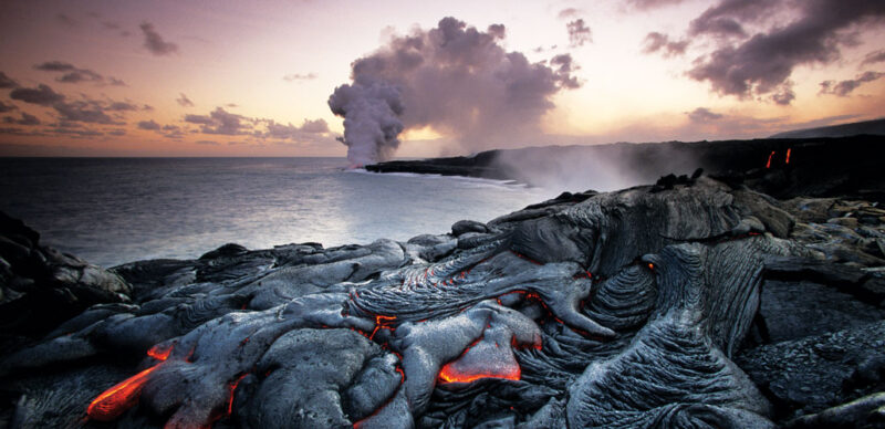
Scientists have peppered the planet with seismometers that can detect the rumble of moving magma within a volcano, and GPS stations can spot changes in land elevation as magma swells below. But anticipating eruptions remains tricky.

BRUCE DAVIDSON/NATURE PICTURE LIBRARY/ALAMY

By Carolyn Gramling
JANUARY 13, 2021 AT 11:00 AM

Some great ideas shake up the world. For centuries, the outermost layer of Earth was thought to be static, rigid, locked in place. But the theory of plate tectonics has rocked this picture of the planet to its core. Plate tectonics reveals how Earth’s surface is constantly in motion, and how its features — volcanoes, earthquakes, ocean basins and mountains — are intrinsically linked to its hot interior. The planet’s familiar landscapes, we now know, are products of an eons-long cycle in which the planet constantly remakes itself.

When plate tectonics emerged in the 1960s it became a unifying theory, “the first global theory ever to be generally accepted in the entire history of earth science,” writes Harvard University science historian Naomi Oreskes, in the introduction to Plate Tectonics: An Insider’s History of the Modern Theory of the Earth. In 1969, geophysicist J. Tuzo Wilson compared the impact of this intellectual revolution in earth science to Einstein’s general theory of relativity, which had produced a similar upending of thought about the nature of the universe. 
 

This article is an excerpt from a series celebrating some of the biggest advances in science over the last century. For an expanded version of the story of plate tectonics, visit Century of Science: Shaking up Earth.

Plate tectonics describes how Earth’s entire, 100-kilometer-thick outermost layer, called the lithosphere, is broken into a jigsaw puzzle of plates — slabs of rock bearing both continents and seafloor — that slide atop a hot, slowly swirling inner layer. Moving at rates between 2 and 10 centimeters each year, some plates collide, some diverge and some grind past one another. New seafloor is created at the center of the oceans and lost as plates sink back into the planet’s interior. This cycle gives rise to many of Earth’s geologic wonders, as well as its natural hazards.

“It’s amazing how it tied the pieces together: seafloor spreading, magnetic stripes on the seafloor … where earthquakes form, where mountain ranges form,” says Bradford Foley, a geodynamicist at Penn State. “Pretty much everything falls into place.”

With so many lines of evidence now known, the theory feels obvious, almost inevitable. But the conceptual journey from fixed landmasses to a churning, restless Earth was long and circuitous, punctuated by moments of pure insight and guided by decades of dogged data collection.

Continents adrift

In 1912, German meteorologist Alfred Wegener proposed at a meeting of Frankfurt’s Geological Association that Earth’s landmasses might be on the move. At the time, the prevailing idea held that mountains formed like wrinkles on the planet as it slowly lost the heat of formation and its surface contracted. Instead, Wegener suggested, mountains form when continents collide as they drift across the planet’s surface. Although now far-flung, the continents were once joined together as a supercontinent Wegener dubbed Pangaea, or “all-Earth.” This would explain why rocks of the same type and age, as well as identical fossils, are found on either side of the Atlantic Ocean, for example.


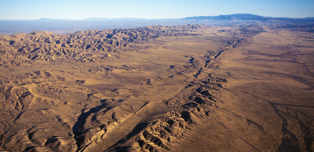
The San Andreas Fault (shown) is the boundary between the Pacific and North American plates.KEVIN SCHAFER/ALAMY

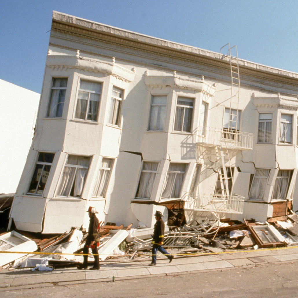
In 1989, a slip of the San Andreas Fault triggered a magnitude 6.9 earthquake that rocked the San Francisco Bay area, causing 63 deaths and billions of dollars in damage (shown).DAVID WEINTRAUB/SCIENCE SOURCE

This idea of drifting continents intrigued some scientists. Many others, particularly geologists, were unimpressed, hostile, even horrified. Wegener’s idea, detractors thought, was too speculative, not grounded enough in prevailing geologic principles such as uniformitarianism, which holds that the same slow-moving geologic forces at work on Earth today must also have been at work in the past. The principle was thought to demand that the continents be fixed in place.

German geologist Max Semper disdainfully wrote in 1917 that Wegener’s idea “was established with a superficial use of scientific methods, ignoring the various fields of geology,” adding that he hoped Wegener would turn his attention to other fields of science and leave geology alone.“O holy Saint Florian, protect this house but burn down the others!” he wrote sardonically.

The debate between “mobilists” and “fixists” raged on through the 1920s, picking up steam as it percolated into English-speaking circles. In 1926, at a meeting in New York City of the American Association of Petroleum Geologists, geologist Rollin T. Chamberlin dismissed Wegener’s hypothesis as a mishmash of unrelated observations. The idea, Chamberlin said, “is of the foot-loose type, in that it takes considerable liberty with our globe, and is less bound by restrictions or tied down by awkward, ugly facts than most of its rival theories.”

One of the most persistent sticking points for Wegener’s idea, now called continental drift, was that it couldn’t explain how the continents moved. In 1928, English geologist Arthur Holmes came up with a potential explanation for that movement. He proposed that the continents might be floating like rafts atop a layer of viscous, partially molten rocks deep inside Earth. Heat from the decay of radioactive materials, he suggested, sets this layer to a slow boil, creating large circulating currents within the molten rock that in turn slowly shift the continents about.

Holmes admitted he had no data to back up the idea, and the geology community remained largely unconvinced of continental drift. Geologists turned to other matters, such as developing a magnitude scale for earthquake strength and devising a method to precisely date organic materials using the radioactive form of carbon, carbon-14.

Data flood in


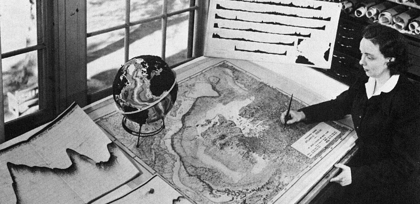
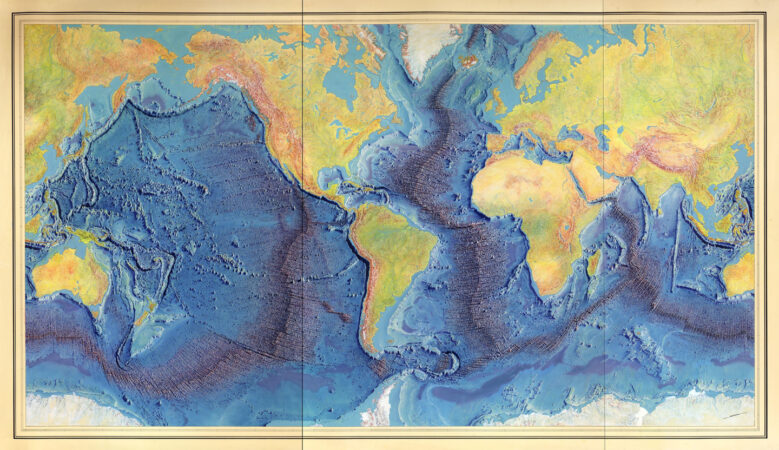
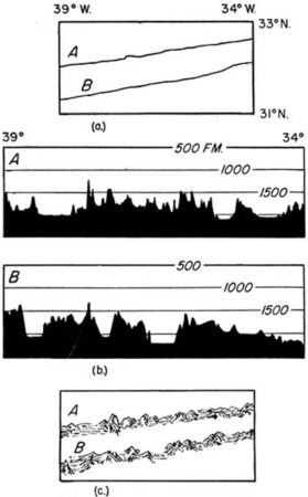
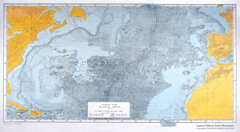
Rekindled interest in continental drift came in the 1950s from evidence from an unexpected source — the bottom of the oceans. World War II had brought the rapid development of submarines and sonar, and scientists soon put the new technologies to work studying the seafloor. Using sonar, which pings the seafloor with sound waves and listens for a return pulse, researchers mapped out the extent of a continuous and branching underwater mountain chain with a long crack running right down its center. This worldwide rift system snakes for over 72,000 kilometers around the globe, cutting through the centers of the world’s oceans.


Armed with magnetometers for measuring magnetic fields, researchers also mapped out the magnetic orientation of seafloor rocks — how their iron-bearing minerals are oriented relative to Earth’s field. Teams discovered that the seafloor rocks have a peculiar “zebra stripe” pattern: Bands of normal polarity, whose magnetic orientation corresponds to Earth’s current magnetic field, alternate with bands of reversed polarity. This finding suggests that each of the bands formed at different times. 

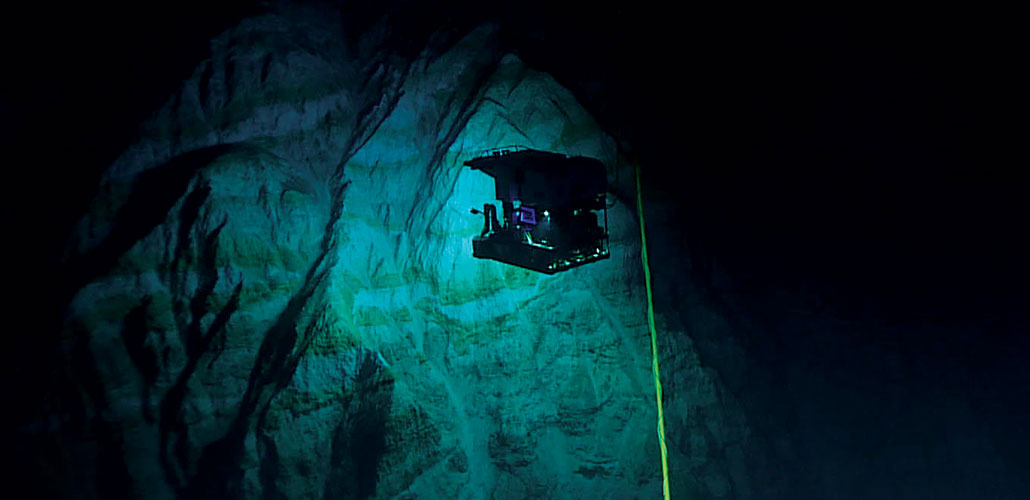
The Pacific Ocean’s Mariana Trench is the deepest known subduction zone, where a tectonic plate sinks back into Earth’s interior. Here, the Deep Discoverer explores the trench at a depth of 6,000 meters in 2016.NOAA OFFICE OF OCEAN EXPLORATION AND RESEARCH

Meanwhile, growing support for the detection and banning of underground nuclear testing also created an opportunity for seismologists: the chance to create a global, standardized network of seismograph stations. By the end of the 1960s, about 120 different stations were installed in 60 different countries, from the mountains of Ethiopia’s Addis Ababa to the halls of Georgetown University in Washington, D.C., to the frozen South Pole. Thanks to the resulting flood of high-quality seismic data, scientists discovered and mapped rumbles along the mid-ocean rift system, now called mid-ocean ridges, and beneath the trenches. The quakes near very deep ocean trenches were particularly curious: They originated much deeper underground than scientists had thought possible. And the ridges were very hot compared with the surrounding seafloor, scientists learned by using thin steel probes inserted into cores drilled from shipboard into the seafloor.

In the early 1960s, two researchers working independently, geologist Harry Hess and geophysicist Robert S. Dietz, put the disparate clues together — and added in Holmes’ old idea of an underlying layer of circulating currents within the hot rock. The mid-ocean ridges, each asserted, might be where circulation pushes hot rock toward the surface. The powerful forces drive pieces of Earth’s lithosphere apart. Into the gap, lava burbles up — and new seafloor is born. As the pieces of lithosphere move apart, new seafloor continues to form between them, called “seafloor spreading.”

 
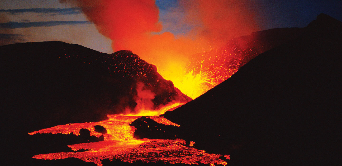
Research suggests that volcanic island chains form as plates move over upwellings of magma. But the origin of the Hawaiian Islands (Kilauea volcano shown) and other similar chains remains something of a geologic puzzle.ART WOLFE/GETTY IMAGES

The momentum culminated in a two-day gathering of perhaps just 100 earth scientists in 1966, held at the Goddard Institute for Space Studies in New York. “It was quite clear, at this conference in New York, that everything was going to change,” University of Cambridge geophysicist Dan McKenzie told the Geological Society of London in 2017 in a reflection on the meeting.

But going in, “no one had any idea” that this meeting would become a pivotal moment for the earth sciences, says seismologist Lynn Sykes of Columbia University. Sykes, then a newly minted Ph.D., was one of the invitees; he had just discovered a distinct pattern in the earthquakes at mid-ocean ridges. This pattern showed that the seafloor on either side of the ridges was pulling apart, a pivotal piece of evidence for plate tectonics.

At the meeting, talk after talk piled data on top of data to support seafloor spreading, including Sykes’ earthquake data and those symmetrical patterns of zebra stripes. It soon became clear that these findings were building toward one unified narrative: Mid-ocean ridges were the birthplaces of new seafloor, and deep ocean trenches were graves where old lithosphere was reabsorbed into the interior. This cycle of birth and death had opened and closed the oceans over and over again, bringing the continents together and then splitting them apart.

The evidence was overwhelming, and it was during this conference “that the victory of mobilism was clearly established,” geophysicist Xavier Le Pichon, previously a skeptic of seafloor spreading, wrote in 2001 in his retrospective essay “My conversion to plate tectonics,” included in Oreskes’ book.
Plate tectonics emerges

The whole earth science community became aware of these findings the following spring, at the American Geophysical Union’s annual meeting. Wilson laid out the various lines of evidence for this new view of the world to a much larger audience in Washington, D.C. By then, there was remarkably little pushback from the community, Sykes says: “Right away, they accepted it, which was surprising.”

Scientists now knew that Earth’s seafloor and continents were in motion, and that ridges and trenches marked the edges of large blocks of lithosphere. But how were these blocks moving, all in concert, around the planet? To plot out the choreography of this complex dance, two separate groups seized upon a theorem devised by mathematician Leonhard Euler way back in the 18th century. The theorem showed that a rigid body moves around a sphere as though it is rotating around an axis. McKenzie and geophysicist Robert Parker used this theorem to calculate the dance of the lithospheric blocks — the plates. Unbeknownst to them, geophysicist W. Jason Morgan independently came up with a similar solution

 
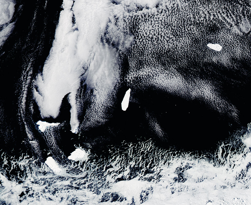
Shifting landmasses — such as the opening of the Drake Passage between South America and Antarctica (icebergs around Elephant Island shown) — can alter currents, and climates.NASA IMAGE BY JEFF SCHMALTZ, LANCE/EOSDIS RAPID RESPONSE

With this last piece, the unifying theory of plate tectonics was born. The hoary wrangling over continental drift now seemed not only antiquated, but also “a sobering antidote to human self-confidence,” physicist Egon Orowan told Science News in 1970.

People have benefited greatly from this clearer vision of Earth’s workings, including being able to better prepare for earthquakes, tsunamis and volcanoes. Plate tectonics has also shaped new research across the sciences, offering crucial information about how the climate changes and about the evolution of life on Earth.

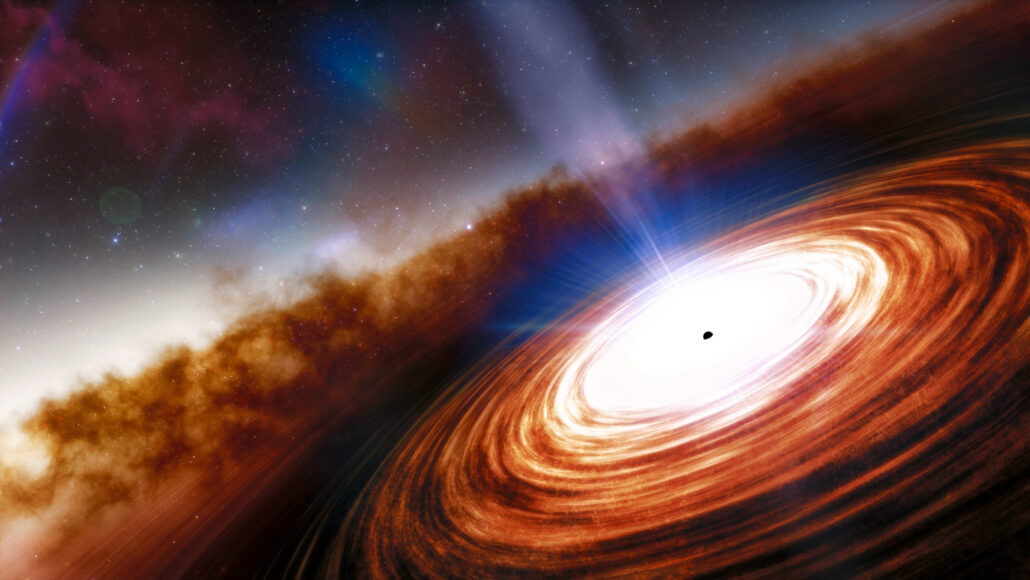
And yet there’s still so much we don’t understand, such as when and how the restless shifting of Earth’s surface began — and when it might end. Equally puzzling is why plate tectonics doesn’t appear to happen elsewhere in the solar system, says Lindy Elkins-Tanton, a planetary scientist at Arizona State University in Tempe. “How can something be a complete intellectual revolution and also inexplicable at the same time?”

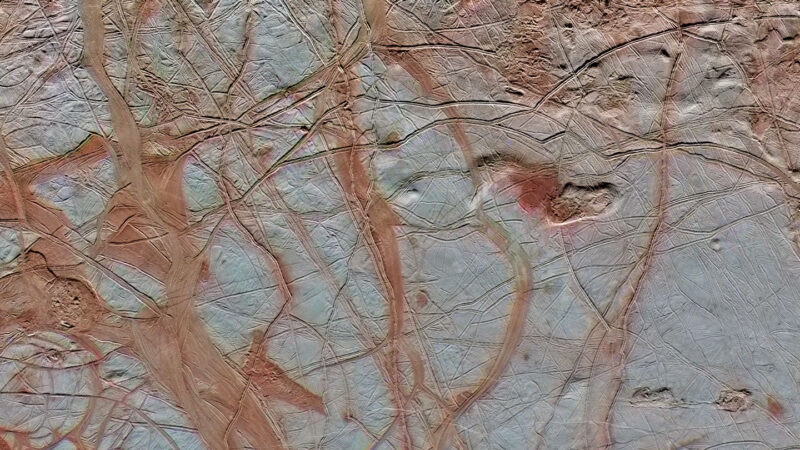
Jupiter’s frozen moon Europa (shown) has its own form of icy plate tectonics.NASA, JPL-CALTECH, SETI INSTITUTE

Crucible of life


Earth is the only known world with plate tectonics. It’s also the only one known to harbor life.

Planetary scientists puzzle over whether and how these two facts might be related — and what it means for just how unusual Earth really is, says Lindy Elkins-Tanton, a planetary scientist at Arizona State University in Tempe. “Nobody knows how plate tectonics began on Earth, and why it didn’t begin elsewhere,” she adds. “It’s a mystery that connects to a lot of other mysteries, and one of those is habitability.”

We know plate tectonics plays a powerful role in keeping Earth habitable, primarily by moving carbon around. “It’s responsible for mediating the climate on long geological time scales, making sure the climate is more or less temperate for life,” says Roger Fu, a geophysicist at Harvard University.

When two tectonic plates collide, one can slide beneath the other, carrying rocks bearing carbon deep into the planet’s interior. The subducting plate begins to melt, and volcanoes bloom on the overlying plate, belching carbon dioxide and other gases into the atmosphere. As carbon dioxide builds up, it warms the planet through the greenhouse effect.

This warmer atmosphere then speeds up weathering of rocks on Earth’s surface, by boosting the chemical reaction between carbon dioxide–rich rainwater and the rocks. Those reactions draw the gas out of the atmosphere to form new carbon minerals. The minerals wash into the ocean, where tiny ocean creatures use the carbon to build their calcium carbonate shells. Ultimately those creatures die, their shells sinking to the ocean floor and becoming carbonate rocks themselves. As more and more carbon dioxide gets sequestered away from the atmosphere in this way, the planet cools — until, eventually, the slow grind of plate tectonics carries the carbonate into the planet’s interior with a subducting plate

.
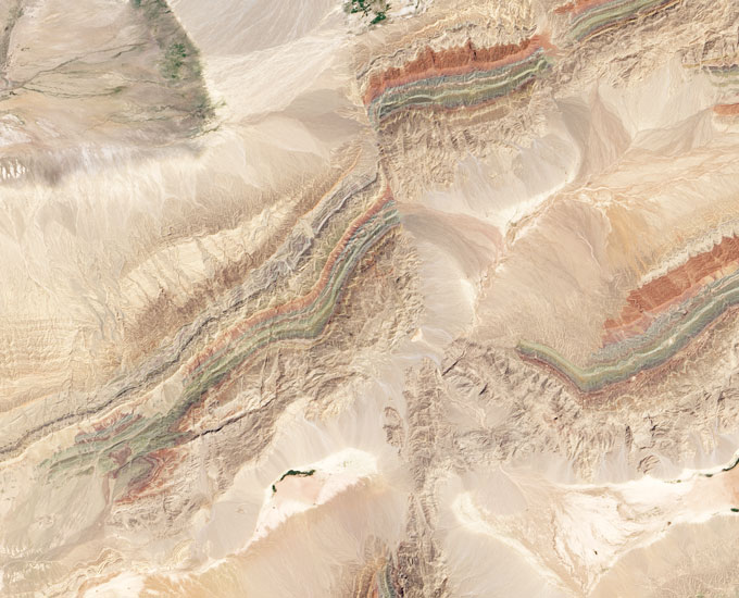
Signs of plate tectonics are clearly visible on Earth’s surface (Piqiang Fault in China’s Xinjiang Province shown). Scientists wonder whether similar features on other planets could be clues to habitability.NASA

This cycle, playing out over many millions of years, doesn’t just keep temperatures mild. The churning also keeps oxygen, nitrogen, phosphorus and other nutrients cycling through the atmosphere, oceans and rocks — and chemically transforms them into forms that living organisms can use.

“That’s not to say that life wouldn’t happen without plate tectonics,” Fu says. “But it would be very different.”

In fact, the first life on Earth may predate the onset of plate tectonics. The planet’s ancient rocks bear traces of life dating to at least 3.4 billion years ago, several hundred million years before the earliest known evidence for any plate motions, in the form of fossilized stromatolites, layered structures made of microbes and minerals. Similar microbial communities exist in modern times at hot springs, such as those of Yellowstone National Park. Some scientists to speculate that hot springs — which contain the biochemical recipe for life, including chemical elements, water and energy — may have set the stage for Earth’s earliest life.

It’s certainly theoretically possible for planets without plate tectonics — like the early Earth — to have livable atmospheres and liquid water, as well as abundant heat, says Bradford Foley, a geodynamicist at Penn State. Foley has simulated how much carbon dioxide could seep out from the interior of “stagnant lid” planets — planets like Mars and Mercury that have a single, continuous piece of lithosphere that sits like a cold, heavy lid over the hot interior. Even on these planets, Foley says, “we still have volcanism,” because there’s still hot rock circulating beneath that heavy lid. Those eruptions release carbon dioxide to the atmosphere and produce fresh new rock for weathering.

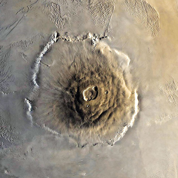
Mars shows signs of volcanic activity (Olympus Mons shown) but no known plate tectonics.JPL, NASA

Volcanism on a climate-altering scale might not last as long as it does when plate tectonics keeps things churning along, but it theoretically could persist for 1 billion or 2 billion years, Foley says. That means that some stagnant lid planets could create an atmosphere and even have temperate climates with liquid water, at least for a time.

Then there’s Europa, Jupiter’s icy moon. The surface of the moon is broken into a mosaic of plates of ice that slide past and over and under one another, much like those on Earth. “Instead of subduction, it’s referred to as subsumption,” Fu says. But the result of this icy cycle may be similar to the hard-rock recycling on Earth, moving nutrients between surface ice and liquid ocean below, which in turn could help support life on the moon.

“What exactly plate tectonics is isn’t an answered question,” Fu says. The term, he says, has become a catchall that encompasses numerous physical features on Earth — mid-ocean ridges, subduction, moving continents — as well as geochemical processes like nutrient cycling. “But there’s no guarantee they always have to happen together.”

Scientists instinctively turn to Earth as a template for studying other worlds, and as an example of what to look for in the search for habitability, Elkins-Tanton says. “So many of the things we try to explain in the natural sciences relies on us being in the middle of the bell curve,” she says. “If it turns out we’re unusual, we’re a bit of an outlier, then explaining things is much harder.”

It may be that each world has its own eclectic history, she says. Earth’s happens to include the powerful cycle of plate tectonics. But life elsewhere might have found another way. — Carolyn Gramling


A version of this article appears in the January 16, 2021 issue of Science News.

About Carolyn Gramling
 is the earth & climate writer. She has bachelor’s degrees in geology and European history and a Ph.D. in marine geochemistry from MIT and the Woods Hole Oceanographic Institution.
‘The New Climate War’ exposes tactics of climate change ‘inactivists’

Climate scientist Michael Mann argues outright denialism has morphed into inactivism

Outright denial of climate change is giving way to subtler efforts to delay action on reducing fossil fuel emissions, argues climate scientist Michael Mann. One tactic, he says, is to shift responsibility away from fossil fuel companies (a gas flare at a North Dakota oil well site, shown) and to individuals.
ANDREW BURTON/GETTY IMAGES

By Carolyn Gramling

JANUARY 15, 2021 


The New Climate War
Michael E. Mann
Public Affairs, $29

Sometime around the fifth century B.C., the Chinese general and military strategist Sun Tzu wrote in his highly quotable treatise The Art of War, “If you know the enemy and know yourself, you need not fear the result of a hundred battles.”

In The New Climate War, climate scientist Michael Mann channels Sun Tzu to demystify the myriad tactics of “the enemy” — in this case, “the fossil fuel companies, right-wing plutocrats and oil-funded governments” and other forces standing in the way of large-scale action to combat climate change. “Any plan for victory requires recognizing and defeating the tactics now being used by inactivists as they continue to wage war,” he writes.

Mann is a veteran of the climate wars of the 1990s and early 2000s, when the scientific evidence that the climate is changing due to human emissions of greenhouse gases was under attack. Now, with the effects of climate change all around us (SN: 12/21/20), we are in a new phase of those wars, he argues. Outright denial has morphed into “deception, distraction and delay.”

Such tactics, he says, are direct descendants of earlier public relations battles over whether producers or consumers must bear ultimate responsibility for, say, smoking-related deaths. When it comes to the climate, Mann warns, an overemphasis on individual actions could eclipse efforts to achieve the real prize: industrial-scale emissions reductions.

He pulls no punches, calling out sources of “friendly fire” from climate advocates who he says divide the climate community and play into the “enemy’s” hands. These advocates include climate purists who lambaste scientists for flying or eating meat; science communicators who push fatalistic visions of catastrophic futures; and idealistic technocrats who advocate for risky, pie-in-the-sky geoengineering ideas. All, Mann says, distract from what we can do in the here and now: regulate emissions and invest in renewable energy.

The New Climate War’s main focus is to combat psychological warfare, and on this front, the book is fascinating and often entertaining. It’s an engrossing mix of footnoted history, acerbic political commentary and personal anecdotes. As far as what readers can do to assist in the battle, Mann advocates four strategies: Disregard the doomsayers; get inspired by youth activists like Greta Thunberg; focus on educating the people who will listen; and don’t be fooled into thinking it’s too late to take action to change the political system.

Buy The New Climate War from Amazon.com. Science News is a participant in the Amazon Services LLC Associates Program. Please see our FAQ for more details.


About Carolyn Gramling  is the earth & climate writer. She has bachelor’s degrees in geology and European history and a Ph.D. in marine geochemistry from MIT and the Woods Hole Oceanographic Institution
The most ancient supermassive black hole is bafflingly big

The black hole doesn’t fit theories of how the cosmic beasts grow so massive


A quasar is a supermassive black hole in the core of a galaxy, wrapped in a bright disk of material. The most distant quasar now known is J0313-1806 (illustrated), which dates back to when the universe was a mere 670 million years old.

NOIRLAB/NSF/AURA/J. DA SILVA


By Maria Temming


The most ancient black hole ever discovered is so big it defies explanation.

This active supermassive black hole, or quasar, boasts a mass of 1.6 billion suns and lies at the heart of a galaxy more than 13 billion light-years from Earth. The quasar, dubbed J0313-1806, dates back to when the universe was just 670 million years old, or about 5 percent of the universe’s current age. That makes J0313-1806 two times heavier and 20 million years older than the last record-holder for earliest known black hole (SN: 12/6/17).

Finding such a huge supermassive black hole so early in the universe’s history challenges astronomers’ understanding of how these cosmic beasts first formed, researchers reported January 12 at a virtual meeting of the American Astronomical Society and in a paper posted at arXiv.org on January 8.

Supermassive black holes are thought to grow from smaller seed black holes that gobble up matter. But astronomer Feige Wang of the University of Arizona and colleagues calculated that even if J0313-1806’s seed formed right after the first stars in the universe and grew as fast as possible, it would have needed a starting mass of at least 10,000 suns. The normal way seed black holes form — through the collapse of massive stars — can only make black holes up to a few thousand times as massive as the sun.

A gargantuan seed black hole may have formed through the direct collapse of vast amounts of primordial hydrogen gas, says study coauthor Xiaohui Fan, also an astronomer at the University of Arizona in Tucson. Or perhaps J0313-1806’s seed started out small, forming through stellar collapse, and black holes can grow a lot faster than scientists think. “Both possibilities exist, but neither is proven,” Fan says. “We have to look much earlier [in the universe] and look for much less massive black holes to see how these things grow.”

AMERICAN PROTESTANT
Spiritual advisor to Barack Obama and George W. Bush sentenced to 6 years for multi-million dollar China bonds fraud

© David J. Phillip/AP Photos File photo of Kirbyjon H. Caldwell, former spiritual advisor to Barack Obama and George W. Bush and former Senior Pastor of Windsor Village United Methodist Church, during an interview in Houston on July 31, 2000. 

The spiritual advisor for both Barack Obama and George W. Bush during their time as President has been sentenced to six years for his role in a multi-million dollar investment fraud schem
Kirbyjon H. Caldwell, 67, was sentenced by US District Judge S. Maurice Hicks on Wednesday in Shreveport, Louisiana, where he and his co-defendant, Gregory Alan Smith, were indicted in 2018.

He spoke at the 2000 Republican National Convention, delivered the benediction at Bush's 2005 inauguration, and officiated his daughter Jenna's 2008 wedding, the New York Times reported

The spiritual advisor for both Barack Obama and George W. Bush during their time as President has been sentenced to six years for his role in a multi-million dollar investment fraud scheme.

Kirbyjon H. Caldwell, 67, was sentenced by US District Judge S. Maurice Hicks on Wednesday in Shreveport, Louisiana where he and his co-defendant, Gregory Alan Smith, were indicted in 2018.

Caldwell was formerly the Senior Pastor of Windsor Village United Methodist Church, a mega-church in his native Houston, Texas, which has around 14,000 members, the Associated Press reported.

According to the New York Times, he spoke at the 2000 Republican National Convention, delivered the benediction at Bush's 2005 inauguration, and officiated his daughter Jenna's wedding in 2008.

Caldwell supported Obama's 2008 presidential run and was part of a group of Christian pastors who would pray with him as well as being on his healthy fatherhood and family task force, the NYT added.

Through Smith, a 55-year-old, Shreveport-based investment advisor, he began using his influence to persuade people to invest in historical Chinese bonds in early 2013, the Associated Press added.

They were told that they would gain partial bond ownership and would very quickly receive large returns on their investments.

Additionally, they were given "participation agreements" which said if the sale failed then their funds would be returned within a certain period of time, and were told to wire funds into one of the many bank accounts he owned or control.

However, the bonds were historical Chinese ones, issued by the former Republic of China before it lost power to the communist government in 1949.

The bonds aren't recognized by China's current government and have no investment value whatsoever. In fact, they are considered to be collectibles by the Securities and Exchange Commission.

Between 2013 and 2014, they made $3.5 million from the scheme. The profits were divided between Caldwell, Smith, and others. The former pastor received $900,000 which he used to maintain his lifestyle and pay down credit cards and mortgages.

In a statement provided by the Department of Justice, Acting US Attorney Alexander C. Van Hook said: "The defendants in this case abused the trust that the victims had placed in them."

"This defendant used his status as the pastor of a mega-church to help convince the many victim investors that they were making a legitimate investment but instead he took their hard-earned money from them and used it for his own personal gain," he continued.

Caldwell was ordered to report to the Bureau of Prisons on June 22, 2021, for conspiracy to commit wire fraud.

Caldwell was also ordered to pay $3,588,500 restitution and a $125,000 fine while his co-defendant, Gregory Alan Smith, was sentenced to six years in prison in November.

Hundreds of Parler videos from Capitol riot republished in chronological timeline

Jon Porter THE VERGE

ProPublica has published a new interactive resource of over 500 videos taken in Washington, DC on January 6th, the day of the Capitol riots, offering an unfiltered look at the day’s events. The videos were sourced from Parler, the social network popular with Trump’s supporters, whose database of over one million videos was archived before the service was taken offline.
© Photo Illustration by Thiago Prudêncio/SOPA Images/LightRocket via Getty Images

We’ve covered previous attempts to organize these videos into easy-to-view online resources, like this interactive map from Patr10tic. But what’s notable about ProPublica’s site is how easily you can scrub through a timeline of videos and sort by general location: Around DC, Near Capitol, and Inside Capitol. You can start by watching videos of crowds attending President Trump’s inflammatory speech at midday, before seeing events turn violent over the course of the afternoon.
© Screenshot: ProPublica Videos are organized chronologically, and can be filtered based on location.

It’s an eye-opening resource which captures videos of the mob’s violent actions, including vandalism and threats against lawmakers. Since the videos are organized chronologically, you’ll often see the same scene captured from multiple angles, making it much easier to see what’s actually happening despite the chaos.

In an accompanying writeup, ProPublica outlines how it ended up with the over 500 videos contained in the resource. It says it originally got the videos from an anonymous programmer who archived over 1 million clips from Parler before it went offline. ProPublica then pulled out around 2,500 videos based on the time they were uploaded and their location data. From these, its staff selected over 500 videos which they believed to be newsworthy and relevant to the day’s events.

Despite the amount of videos contained in the resource, ProPublica notes that there are some notable blindspots. For example, it only has one video from inside the Senate or House chambers, despite media footage that suggests rioters were filming inside the rooms.