Monday, August 02, 2021


PLANET IN PERIL
SATELLITE IMAGES REVEAL A CLIMATE CRISIS NIGHTMARE IN SIBERIA


Understanding this study’s findings “may make the difference between catastrophe and apocalypse.”

Dimitar Dilkoff/Getty Images

TARA YARLAGADDA


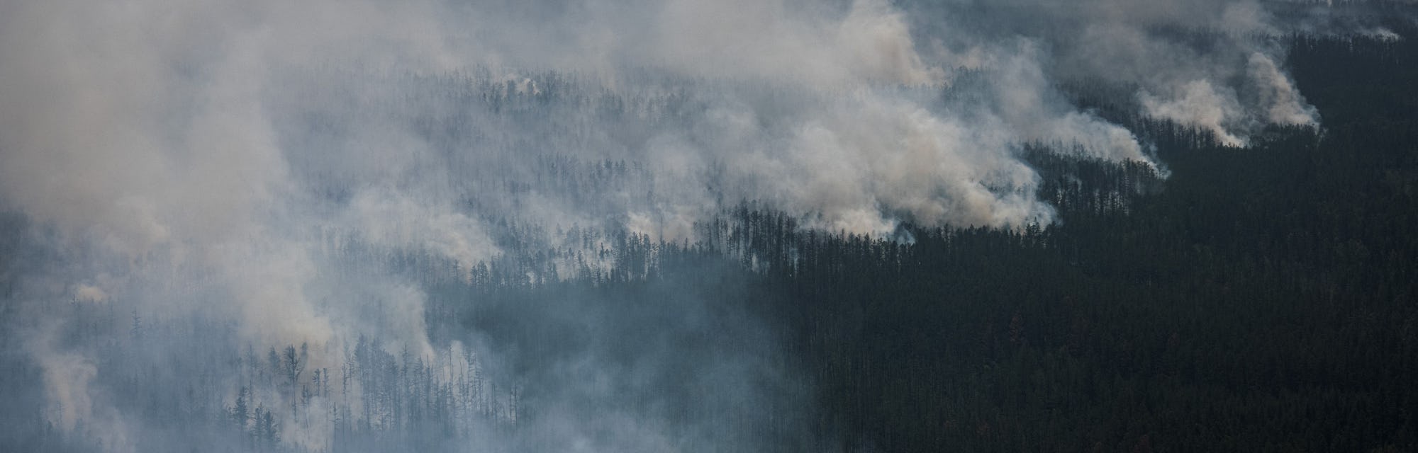
TRAVERSE DEEP INTO NORTHERN SIBERIA, and you’ll find the Yenisey-Khatanga Basin. As of late, this remote part of the world is predominantly known for two things: its untapped potential as a massive source of oil and gas, and its proximity to the wildfires that have raged in Siberia this summer.

Now, scientists suggest another factor that demands our attention: According to a study published Monday in the journal Proceedings of the National Academy of Sciences, considerable amounts of methane are being released from a previously unexplored source.

Arctic methane is typically connected to two sources: organic matter in permafrost and methyl clathrate (molecules of methane frozen in ice crystals). This study spotlights a third — one released from fractures and pockets in the permafrost zone that’s become unstable due to warming.

As the climate crisis worsens, understanding this study’s findings “may make the difference between catastrophe and apocalypse,” lead author Nikolaus Froitzheim, a professor at the University of Bonn’s Institute of Geosciences in Germany, tells Inverse.


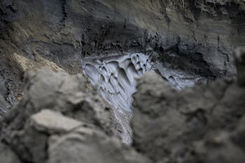
Permafrost melts into the Kolyma River in Siberia during July 2019. Record-breaking heat waves increase permafrost thaw, triggering the release of methane and contributing to global warming. Getty

WHAT YOU NEED TO KNOW FIRST — The thawing of the Siberian permafrost — a mixture of rock, ice, soil, and the organic remains of animals and plants — is associated with the release of methane in the atmosphere. Global warming has led to an increased thawing of the permafrost.


Methane is a potent greenhouse gas emission with 84 to 86 times the warming power of carbon dioxide over a 20-year period.

After conducting a satellite analysis of the Yenisey-Khatanga Basin, Froitzheim and colleagues found we’ve been overlooking another crucial source of methane emissions from the Siberian permafrost: sites of “thermogenic methane.”

HOW THE DISCOVERY WAS MADE— The researchers used an interactive satellite mapping technology, known as PULSE, to calculate methane emissions in the air above the Yenisey-Khatanga Basin in Siberia.
“THERE IS A LOT OF NATURAL GAS IN THE SUBSURFACE OF SIBERIA.”

The researchers looked specifically at methane emissions following a heat wave in Siberia in June 2020, as well as methane emissions in the area in spring 2021. They also compared the methane emissions on the satellite map to a geological map showing where certain rock formations occur.

The researchers then made an alarming discovery:

“We found that two elongated areas of elevated methane concentration on the PULSE map perfectly coincide with two stripes where limestone formations occur in the subsurface,” Froitzheim says.


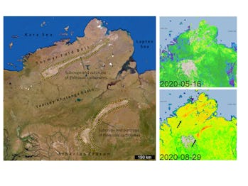
Satellite imagery shows atmospheric methane concentrations during May and August 2020 over the Taymyr Peninsula in Northern Siberia. Nikolaus Froitzheim, Dmitry Zastrozhnov, and GHGSAT.


WHAT’S NEW — Those limestone formations are likely sites of “thermogenic methane” or natural gas deposits of methane hidden deep underneath the permafrost. Natural gas, the team writes, can be “trapped under or within the permafrost layer and released when it thaws.”

The methane couldn’t have come from the usual microbes breaking down organic matter in the soil, since there is very little soil in these limestone formations.
HEAT “MADE THIS MIXTURE UNSTABLE AND OPENED PATHWAYS.”

Instead, Frotzheim suspects record-breaking temperatures disturbed fractures in the limestone, providing an opportunity for natural gas from deeper within the permafrost to escape into the atmosphere.

“Our hypothesis is that the heat made this mixture unstable and opened pathways through which natural gas from depth could reach the surface,” Frotzheim says. “There is a lot of natural gas in the subsurface of Siberia, and some of these reservoirs may have been tapped.”

Comparing maps over a one-year period between May 2020 and May 2021, the scientists found that “atmospheric methane concentrations have increased considerably during and after the 2020 heat wave.”

“After” is key: The increase in methane was highest in June/August 2020 as well as in March/April 2021, demonstrating how warming can trigger methane release long after the initial heat wave.

WHY IT MATTERS — The events in Northern Siberia are all, in a way, connected: the fires, the hunt for natural fuel, and the release of a powerful greenhouse gas.


Methane traps heat in the atmosphere and plays a major role in climate change. The heat wave that ignited Siberia’s wildfires is part of a trend driven by human-induced climate change — so is the thawing of Siberia’s permafrost. The extraction of oil and gas also releases methane. These factors are all connected.

It’s a domino effect that doesn’t appear to be slowing down: Record-breaking temperatures hit Siberia in 2020 and once again in the summer of 2021.


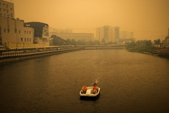
In July 2021, a couple attempts to evade smoke hanging over the city of Yakutsk, in Siberia. Dimitar Dilkoff/Getty Images

As temperatures continue to skyrocket due to the climate crisis, the permafrost thaw may unleash unknown quantities of this deep methane gas into the atmosphere. In 2018, NASA predicted a possible “future boost” of methane from Arctic permafrost — that prediction is coming true.

Based on their findings, the researchers conclude: “As a result, the permafrost–methane feedback may be much more dangerous than suggested by studies accounting for microbial methane alone.”


WHAT’S NEXT — Methane may be coming from deep within the Siberian ice, but scientists are still scratching the surface of permafrost research.

Froitzheim and his colleagues still aren’t sure why methane emissions began spiking more than half a year after the summer 2020 heat wave.

The team calls on more scientists to conduct research to “find out how fast and how much methane may be emitted this way,” including an analysis of methane in air samples and calculations of methane gas destabilization in the rocks.

While these measures are a way for scientists to better understand the exact amount of methane released due to permafrost, they’re not a solution.

These findings don’t necessarily mean the permafrost is beyond repair, the scientists suggest. The amount of methane being released from these deep methane reserves are relatively small compared to, say oilfields in Libya or wetlands in India, Froitzheim says. To have any chance of halting the release of methane from the permafrost we need to immediately begin reducing greenhouse gas emissions from fossil fuels and other industries.

“I do not think that these particular observations mean that we have passed a point of no return,” Frotzheim says.

Abstract: 

Anthropogenic global warming may be accelerated by a positive feedback from the mobilization of methane from thawing Arctic permafrost. There are large uncertainties about the size of carbon stocks and the magnitude of possible methane emissions. Methane cannot only be produced from the microbial decay of organic matter within the thawing permafrost soils (microbial methane) but can also come from natural gas (thermogenic methane) trapped under or within the permafrost layer and released when it thaws. In the Taymyr Peninsula and surroundings in North Siberia, the area of the worldwide largest positive surface temperature anomaly for 2020, atmospheric methane concentrations have increased considerably during and after the 2020 heat wave. Two elongated areas of increased atmospheric methane concentration that appeared during summer coincide with two stripes of Paleozoic carbonates exposed at the southern and northern borders of the Yenisey-Khatanga Basin, a hydrocarbon-bearing sedimentary basin between the Siberian Craton to the south and the Taymyr Fold Belt to the north. Over the carbonates, soils are thin to nonexistent and wetlands are scarce. The maxima are thus unlikely to be caused by microbial methane from soils or wetlands. We suggest that gas hydrates in fractures and pockets of the carbonate rocks in the permafrost zone became unstable due to warming from the surface. This process may add unknown quantities of methane to the atmosphere in the near future.

Methane release from carbonate rock formations in the Siberian permafrost area during and after the 2020 heat wave

 See all authors and affiliations

  1. Edited by Thure E. Cerling, The University of Utah, Salt Lake City, UT, and approved July 2, 2021 (received for review April 22, 2021)

Abstract

Anthropogenic global warming may be accelerated by a positive feedback from the mobilization of methane from thawing Arctic permafrost. There are large uncertainties about the size of carbon stocks and the magnitude of possible methane emissions. Methane cannot only be produced from the microbial decay of organic matter within the thawing permafrost soils (microbial methane) but can also come from natural gas (thermogenic methane) trapped under or within the permafrost layer and released when it thaws. In the Taymyr Peninsula and surroundings in North Siberia, the area of the worldwide largest positive surface temperature anomaly for 2020, atmospheric methane concentrations have increased considerably during and after the 2020 heat wave. Two elongated areas of increased atmospheric methane concentration that appeared during summer coincide with two stripes of Paleozoic carbonates exposed at the southern and northern borders of the Yenisey-Khatanga Basin, a hydrocarbon-bearing sedimentary basin between the Siberian Craton to the south and the Taymyr Fold Belt to the north. Over the carbonates, soils are thin to nonexistent and wetlands are scarce. The maxima are thus unlikely to be caused by microbial methane from soils or wetlands. We suggest that gas hydrates in fractures and pockets of the carbonate rocks in the permafrost zone became unstable due to warming from the surface. This process may add unknown quantities of methane to the atmosphere in the near future.

In a warming world, the release of CO2 and methane from thawing permafrost to the atmosphere may lead to a positive feedback by increasing the concentration of greenhouse gases (13). Methane is particularly critical because of its high global warming potential per mass unit. In review articles on this subject, the focus is mainly on organic matter stored in frozen soils and its microbial decay and release as microbial methane upon thawing (13). However, thermogenic methane, i.e., natural gas from the deeper subsurface, may also contribute to the feedback. A proportion of thermogenic methane in addition to the dominant microbial methane was found in gas emission craters in Western Siberia (4). For the subsea permafrost in the East Siberian Arctic Shelf, it was argued that thawing can make the permafrost layer permeable for gas stored as hydrates or as free gas within the permafrost layer and also for subpermafrost gas (5). Isotopic signatures of methane released in the East Siberian Arctic Shelf are consistent with an origin as old, deep, and likely thermogenic methane (6).

In 2020, Siberia saw an extreme heat wave (7). The maximum of the annual surface temperature anomaly, of up to 6 °C above the 1979–2000 baseline, was located on the Taymyr Peninsula in North Siberia (https://climatereanalyzer.org/). The atmospheric concentrations of methane in northern Siberia show a marked increase since June 2020, revealed by the PULSE map of methane concentrations (https://pulse.ghgsat.com/). The increase was strongest in July/August 2020 and in March/April 2021. During summer, 2020, two conspicuous elongated areas of increased methane concentration (in the following: “elongated maxima”) appeared (Fig. 1), approximately parallel to each other, several hundred kilometers long, and trending SW–NE. In early 2021, methane concentration increased over the entire area. In the present communication, we demonstrate the geological significance of these maxima and discuss possible reasons for the increased methane concentrations, as well as consequences for the permafrost–methane feedback.

Fig. 1.

Atmospheric methane concentrations in North Siberia during 2020–2021, from PULSE map (https://pulse.ghgsat.com/). Note two elongated maxima of methane concentration (arrows) coinciding with carbonate outcrop areas (Fig. 2), and region-wide concentration increase in March to April 2021. See Fig. 2 for location. Curve shows monthly means of 2-m temperature in Siberia (55°N–76°N, 70°E–180°E) during the study period (https://climatereanalyzer.org/).

Results

The two elongated methane concentration maxima correlate well with two stripes characterized by outcrops and stone runs of carbonate rocks (Fig. 2). In these two areas, soil is thin to nonexistent, i.e., the carbonate rocks crop out at the surface, vegetation is scarce, and the proportion of wetlands is low. The northern lineament coincides with the Early Paleozoic Siberian passive-margin carbonate succession. The southern lineament mimics outcrops of Paleozoic carbonates covering the rim of the Siberian Craton. The area between the two lineaments is occupied by Late Paleozoic and Mesozoic, predominantly clastic sedimentary rocks of the Yenisey-Khatanga Basin (8). The region is underlain by continuous permafrost about 700 m thick in the Yenisey-Khatanga Basin (9).

Fig. 2.

Geology of the Taymyr Peninsula in North Siberia. (A) Satellite image (ArcGIS World Imagery). Carbonate rock formations on both sides of the Yenisey-Khatanga Basin visible as light-colored stripes. Outlines of atmospheric methane concentration anomalies (Fig. 1) indicated as yellow dashed lines. (B) Simplified geological map (modified from ref. 8). Note close coincidence of carbonate formations and methane anomalies.

We studied the evolution of methane concentrations using PULSE, an interactive map of atmospheric methane concentrations launched in 2020 and based on satellite spectroscopy. PULSE shows monthly concentration averages with a 2 × 2-km resolution. The map for a certain date shows concentration averaged over the preceding month. Absolute concentrations are only approximate, but spatial and temporal concentration gradients are well displayed. In May 2020, methane concentrations were low (∼1,800 ppb) and rather uniform in the area of interest. On June 26, near the climax of the heat wave (T curve in Fig. 1), the southern lineament was for the first time clearly visible as an elongated maximum in methane concentration.

In August, the southern maximum was strongest and the northern maximum appeared, and in the following became approximately as strong as the southern one. The situation remained unchanged until March 2021, when concentration started rising across the entire area and the two maxima partly disappeared in the increased background concentrations. On April 10, 2021, almost the entire area showed concentrations around 1,900 ppb. Comparison of the maps for May 16, 2020, and May 15, 2021, shows the significant increase of methane concentration within 1 y, focused on northern Siberia.

Discussion

The almost perfect coincidence between the stripes where carbonate rocks crop out and the elongated concentration maxima strongly suggests that the maxima result from geologically controlled methane emissions from the ground. These cannot represent microbial methane from the decay of soil organic matter because soils are thin to nonexistent, nor can they come from wetlands because there are relatively few wetlands on the carbonate rocks, nor from vegetation because there is hardly any. Consequently, the source must be thermogenic methane from the subsurface. The Paleozoic carbonates are potential hydrocarbon reservoir rocks (10). This opens the possibility that methane was emitted from gas stored in the carbonates, probably in the form of gas hydrate. The permafrost in North Siberia contains pockets and layers of gas hydrate, which have caused blowouts during drilling. Hydrates also exist metastably above the hydrate stability zone (11). The shallowest gas blowouts occurred at only 20-m depth (11). Eruption of gas from the mobilization of gas hydrates is assumed to have caused the formation of a gas eruption crater in the Patom hills, further south in Siberia but still in the permafrost zone (12). Importantly, this crater is on Neoproterozoic carbonate rocks, showing that the process of gas eruption does occur in carbonate rocks.

Ice-bonded permafrost is virtually impermeable for gases, leading to permafrost-capped gas reservoirs (9). In the hydrate stability zone, comprising the lower part of the permafrost and several 100 m below, methane and water form gas hydrate. Hydrates located above the present-day stability zone either formed due to ice load during glaciations, which raised the upper boundary of the stability zone to the ground surface, or because of a pressure increase due to freezing of water in pores and closed cavities (511). We suggest that the mobilization of gas hydrate in fractures at shallow level, caused by warming from above during the heat wave, reduced the pressure on deeper gas hydrate, which was then mobilized, and so on, opening vents for increasingly deeper-seated gas. This process can occur in any fractured rock but is expected to be much faster in carbonate rocks, with their network of interconnected fractures and karst cavities, than in other rock types. This may explain why the maxima over the limestone appeared soon after the beginning of the heat wave. Rock composition may also play a role: Increased temperature in the gas-hydrate–hosting carbonates may mobilize hydrous fluid carrying dissolved CO2, which would cause CH4–CO2 replacement in analogy to the guest gas replacement technique applied to hydrate reservoirs, additionally speeding up the methane mobilization process.

The spring 2021 concentration increase is unusual because the area was still snow-covered and temperatures were low (curve in Fig. 1). Methane emissions during spring thaw are known from Arctic permafrost but these occur generally later, around end of May (13). The area of maximum spring 2021 concentration increase coincides with the maximum of 2020 temperature anomaly, i.e., the Taymyr Peninsula and surroundings, making a link between summer 2020 heat wave and spring 2021 methane emission plausible. The spring concentration increase, which is not restricted to the carbonates but occurred in the entire Yenisey-Khatanga Basin and surroundings, may at least partly also reflect gas hydrates from the permafrost. The reason for the delay of approximately half a year is unclear and requires further research.

To conclude, our observations hint at the possibility that permafrost thaw does not only release microbial methane from formerly frozen soils but also, and potentially in much higher amounts, thermogenic methane from reservoirs below and within the permafrost. As a result, the permafrost–methane feedback may be much more dangerous than suggested by studies accounting for microbial methane alone. Gas hydrates in Earth’s permafrost are estimated to contain 20 Gt of carbon (14). Additionally, subpermafrost natural gas reservoirs may be tapped. To clarify how fast methane from these sources can be transferred to the atmosphere, further research is urgently required, including monitoring of air composition, tracking of air movement, collection of air samples for analysis of tracers of thermogenic venting, and modeling of the hydrate destabilization process.

Materials and Methods

We used freely accessible online resources, the PULSE map for methane concentrations (https://pulse.ghgsat.com/) and the Climate Reanalyzer (https://climatereanalyzer.org/) for temperature and snow cover data.

Data Availability

All study data are included in the article and/or supporting information.

Acknowledgments

We thank the editors and two anonymous reviewers for constructive comments.

Footnotes

  • Author contributions: N.F. designed research; N.F., J.M., and D.Z. performed research; D.Z. analyzed data; and N.F. and J.M. wrote the paper.

  • The authors declare no competing interest.


Conservatives may be willing to take on climate change — if you call it something else

Fires are raging in their backyards. 
But many still scoff at global warming

By KATE YODER
SALON
PUBLISHED AUGUST 2, 2021 
Bleached coral on the Great Barrier Reef outside Cairns Australia during a mass bleaching event, thought to have been caused by heat stress due to warmer water temperatures as a result of global climate change. (Getty Images/Brett Monroe Garner

Grist is a nonprofit, independent media organization dedicated to telling stories of climate solutions and a just future.


On July 6, lightning sparked a fast-spreading wildfire in southern Oregon that's now the largest in the country and the state's third-largest on record. The Bootleg Fire, only recently getting contained after a period of cooler weather, has led more than 2,400 people to evacuate, destroyed at least 161 homes, and sent toxic smoke traveling across the country. The heat of the flames was so intense that it spawned a fire tornado.

Drought and extreme heat have plagued the West this year, combining with a century's worth of wildfire suppression for an unprecedented fire season. A warming planet makes these giant fires more likely, and people around the world are seeing the flames and smoke, coming months ahead of schedule, as a wake-up call. So what did locals in the largely rural, conservative parts of Oregon's wildfire country think about the most recent conflagration? Recent reports suggest that many people living near the Bootleg Fire don't see any connection to rising temperatures.

For those who accept the scientific consensus around climate change, this sounds like a denial of reality. But new research suggests that many conservatives won't link extreme weather with global warming no matter how extreme the weather gets in their backyards. Some experts argue that the phrase "climate change" has become so polarizing that you'd be better off avoiding those words altogether if you really want to address the planetary crisis.

"We get so hung up on forcing people to agree with us on the facts that I think we miss the bigger picture," said Brianne Suldovsky, an assistant professor of communication at Portland State University. "You know, I want my conservative uncle to accept that climate science is real and valid and that humans are causing climate change. Fine, but we've tried that, and it's not working."

It's not just conservatives who are ignoring the local evidence about their weather. It's liberals, too. In a working paper, Suldosvky and a statistics researcher at Portland State surveyed people in Oregon, asking them if certain kinds of weather events were getting more or less frequent in their area, and more or less extreme. Then they looked at the ZIP codes that the participants lived in and compared their responses to local data on precipitation rates and temperature.

People who accepted the scientific consensus around climate change saw adverse weather events as being more frequent in their area — even when they weren't. Likewise, people who denied climate change didn't see extreme weather as extreme, even when it was happening right in front of them. People of all political persuasions often choose to see what they want to see.

"What is predicting people's weather perceptions has nothing to do with their actual weather," Suldovsky said. "It really is just whether or not they think climate change is happening, and whether or not they're concerned about it." Suldovsky attributes this to a mental quirk called "motivated reasoning," a tendency people have to look for explanations to justify their preexisting conclusions, rather than weighing the evidence and drawing a conclusion.

The Washington Post recently spoke with locals in the small towns near the Bootleg Fire and found that many conservatives aren't talking about the overheating planet — except maybe to scoff at the idea. They tended to point the finger for the supercharged blazes elsewhere, at environmentalists who have stopped logging efforts, for example. "Now the top end of the Forest Service are a bunch of flower children," one resident of the town of Lakeview, southeast of the fire, told the Post. "That's what the real problem is. It's not that much hotter. It's environmentally caused mismanagement."

Suldovsky grew up in a very conservative household in a rural town in Idaho, and she didn't use to accept the science behind climate change or evolution. She remembers coming to a high school science class prepared with Bible verses, arguing with her teacher that the Earth was only 6,000 years old. Nothing would change her mind — until later on, when she discovered a love of philosophy and questioned her beliefs. She says that "shoving more information" at people, or calling them stupid or anti-science, usually backfires.

"I deeply empathize with feeling like experts aren't on your side, and that science isn't on your side," Suldovsky said. "And that position isn't remedied by being told more science, right?"

Suldovsky recently co-authored another study, published in the journal Climatic Change, that looked at how liberal and conservative Oregonians think differently about climate change. Through surveys, she found that liberals see climate science as simple and certain, and they tend to defer to the experts on climate change, even if what scientists are saying contradicts their personal experience. On the other hand, conservatives see climate science as complex and uncertain and tend to prioritize their own life experience over expert opinion. That's why Suldovsky recommends leveraging conservatives' experiences when talking to them about issues related to our overheating planet (without using the words "climate change," of course).

There's a growing sense among some experts in communication that it's best to avoid the phrase. The American Meteorological Society has recommended talking about more frequent floods, worsening seasonal allergies, and extreme heat without mentioning the root of the problem. Sometimes that means using a byword, like "future-proofing" or "resilience." Other times, it means changing your argument from one focused on climate change to an issue that conservatives tend to care more about, like the economy or energy independence. That approach works better for addressing the root of the problem — reducing carbon dioxide emissions and switching to renewables.

"There are lots of things we can gather support for that … don't necessarily require us to convince people that human-caused climate change is real," Suldovsky said. For example, consider the 115-degree heat wave that melted streetcar cables in Portland, buckled roads in Seattle, and killed more than 1,000 in Oregon, Washington, and British Columbia. It'll be easier to convince conservatives in the Pacific Northwest that they need to be more prepared for super-hot temperatures in the future than to get them to say that the extreme heat was linked to global warming.

There's evidence that this approach works: Towns along the coast of North Carolina have adopted rules that restrict new construction to higher ground, mentioning "flood damage" but ignoring the hot-button topic "sea-level rise." In the Great Plains, local governments have paved the way for bike paths and required tree planting on new developments in the name of outdoor recreation and clean air.

Suldovsky gets that the pragmatic advice to gloss over "climate change" is controversial. But in the end, she said, it's better to get something done than to keep arguing about a mostly lost cause.

"Do you want to prove that you're correct, or do you want to adapt for climate change? It kind of feels like at this point, we need to choose between one or the other."


Monitoring Fukushima radiation on land and sea

30 July 2021


Japanese laboratories monitoring radionuclides in seawater, marine sediment and fish near the damaged Fukushima Daiichi nuclear power plant continue to produce reliable data, according to a new International Atomic Energy Agency (IAEA) report. Meanwhile, Tokyo Electric Power Company plans to rear fish in treated radioactive water from the plant to demonstrate its safety. A University of Georgia study has shown that radioactive contamination in the Fukushima Exclusion Zone can be measured through its resident snakes.

Seawater samples being taken near the Fukushima Daiichi plant (Image: IAEA)

The IAEA has since 2014 organised missions to support the collection of marine samples for interlaboratory comparisons of radioactivity analyses. The first phase of the Marine Monitoring Confidence Building and Data Quality Assurance project covered the years 2014 to 2016. It found that Japan produced reliable data on marine samples near Fukushima Daiichi plant.

In this second phase of the project, the IAEA carried out a range of activities focused on marine monitoring data quality, including interlaboratory comparisons (ILCs) of seawater, sediment and fish samples collected in four sampling missions conducted from 2017 to 2020 near the Fukushima Daiichi plant.

ILCs involve different laboratories separately testing and analysing samples and then comparing results and procedures to determine their reliability and accuracy. The samples in the second phase of the project were analysed at 12 laboratories in Japan, at the IAEA Environment Laboratories in Monaco and two laboratories in other Member States (in Canada and Switzerland) that are part of the network of Analytical Laboratories for the Measurement of Environmental Radioactivity.

"Following these ILCs, the IAEA can confidently report that Japan's sample collection procedures follow the appropriate methodological standards required to obtain representative samples," the new report states. It added that "the results obtained demonstrate a continued high level of accuracy and competence on the part of the Japanese laboratories involved in the analyses of radionuclides in marine samples for the (country's) Sea Area Monitoring Plan".

"It can be concluded that over 97% of the results were not significantly different from each other, and this shows that the participating Japanese laboratories have the capacity to accurately analyse the samples," said Florence Descroix-Comanducci, director of the IAEA's environment laboratories in Monaco. "The results also demonstrate a high level of consistency among the Japanese laboratories and with laboratories in other countries and the IAEA."

The IAEA Marine Monitoring Confidence Building and Data Quality Assurance collaboration with Japan has been extended for a further two years in order to conduct additional ILCs and proficiency tests and build on the already completed work.

Impact on marine life


At the Fukushima Daiichi site, contaminated water is treated by the Advanced Liquid Processing System (ALPS), which removes most of the radioactive contamination, with the exception of tritium. This treated water is currently stored in tanks on-site. The total tank storage capacity amounts to about 1.37 million cubic metres. As of 15 July, almost 1.27 million cubic metres of treated water were being held in the storage tanks. All the tanks are expected to be full around the summer of 2022.

In April, the Japanese government announced its formal decision that the treated water stored at the Fukushima Daiichi site will be discharged into the sea. The basic policy calls for the ALPS-treated water to be discharged "on the condition that full compliance with the laws and regulations is observed, and measures to minimise adverse impacts on reputation are thoroughly implemented".

Japan intends to start releasing the treated water in early 2023, and the entire operation could last for decades.

Tokyo Electric Power Company yesterday announced plans to rear fish, shellfish and seaweed in seawater containing ALPS-treated water. The test is aimed at aimed at easing safety concerns about the release of the water into the sea.

Information will be gathered on the occurrence of health-related abnormalities, as well as the hatching rate of eggs and the survival rate of matured fish. A comparison will also be made of the concentration of radioactive materials, including tritium, in the water used for the trial and the subjects' bodies.

The test is due to begin in the second quarter of 2022. "Rearing is planned to be continued for a while after discharge has been initiated," the company said.

Reptilian receptors


Meanwhile, a study from the University of Georgia (UGA) has shown that radioactive contamination around the Fukushima plant can be measured through tracking snakes. Rat snakes, it says, travel short distances and can accumulate high levels of radionuclides, making them an effective bioindicator of residual radioactivity.

According to the researchers, the snakes' limited movement and close contact with contaminated soil are key factors in their ability to reflect the varying levels of contamination in the area. Tracked snakes were found to move an average of just 65 metres per day.

The team tracked nine rat snakes using a combination of GPS transmitters and manual very-high frequency tracking. The researchers identified 1718 locations of the snakes while tracking them for over a month in the Abukuma Highlands, approximately 15 miles northwest of the Fukushima Daiichi plant.

The new study's findings reinforce the team's previous study published in 2020, which indicated the levels of radiocaesium in the snakes had a high correlation to the levels of radiation in the soil where the snakes were captured.

"Snakes are good indicators of environmental contamination because they spend a lot of time in and on soil," said James Beasley, associate professor at of UGA's Savannah River Ecology Laboratory (SERL) and the Warnell School of Forestry and Natural Resources. "They have small home ranges and are major predators in most ecosystems, and they’re often relatively long-lived species."

"Our results indicate that animal behaviour has a large impact on radiation exposure and contaminant accumulation," said Hanna Gerke, an alumna of SERL and Warnell. "Studying how specific animals use contaminated landscapes helps increase our understanding of the environmental impacts of huge nuclear accidents such as Fukushima and Chernobyl."

Researched and written by World Nuclear News


Scientists researching strange appearance of Arctic salmon asking fishers to send in their catches

Salmon in the Arctic have increased a lot since 2016, says researcher

Atlantic salmon found in the North. The Arctic Salmon Project has been documenting unusual fish caught by community-based harvesters. (Derwin Parr)

Scientists looking at salmon found in Arctic waters are still asking northern harvesters and fishers to submit any unusual catches in exchange for compensation.

It's part of the Arctic Salmon Project, which is a collaborative effort involving Fisheries and Oceans Canada, scientists from the South and local hunters and trappers organizations. 

The idea of the project, said Darcy McNicholl, a biologist with the fisheries and oceans department, is to document the unusual fish being caught by community-based harvesters.

"We encourage fishermen who catch something that they've never seen before to turn it in for a gift cards so that we can dissect it and answer questions that the communities might have," McNicholl said.

That could include questions about what they're eating, where they're coming from and whether they carry diseases. 

Salmon can be a good indicator of change in the Canadian Arctic, McNicholl said.

Fisheries and Oceans Canada has been studying salmon populations in the Arctic since 2000, and collects samples every year as part of the Arctic Salmon Project. In 2019, 2,400 salmon were submitted to the department. The year before, less than 100 salmon were collected.

Darcy McNicholl is a biologist with Fisheries and Oceans Canada. (Submitted by Darcy McNicholl)

McNicholl said prior to 2016, on average there would be maybe a couple 100 each year.

But the work of a masters student doing traditional knowledge work in the N.W.T. suggests there were large numbers of salmon around the 1960s, she said. 

"So, salmon harvest has been occurring in the Northwest Territories before."

Warmer waters

Salmon have been around the Arctic for a number of years but the number has increased a lot since 2016, and 2019 was a busy year, said McNicholl. She said it could be partly because of the rising temperature of water in the South.

"It's pushing salmon into cooler waters, where their eggs can rear, and they can tolerate the cooler temperatures," she explained. "Or they could be following their food, or both."

In any case, McNicholl said the increase in salmon in the last several years is new and scientists are still working out what exactly is driving salmon up North.

As part of the project, locals in various communities — like Ooloosie Aningmiuk and her husband in Kinngait, Nunavut — were trained to collect and receive salmon in various communities. The pair has been helping the department for the past two years.

Aningmiuk said they help monitor the fish that are caught, and the temperature and salt level of the water.

"Being Inuit, we would like to know what we eat, what the water condition is, what the food is like," she said.

"We would like to know how the food is, if they are evolving, or if there are new species."

'Unusual' fish appearances

McNicholl said salmon might not be the only creatures making their way North.

Once, one of the project's conservationists reported this sighting of a salmon shark — normally only found in Alaska — in Kuglutuk, Nunavut.

"That was very unusual," McNicholl said. "Somehow this one made it all the way into western Nunavut." 

She added that pink salmon are expanding in all directions across the Canadian North.

McNicholl said the work to learn more about fish species in the Arctic is important because sometimes they aren't new — they just haven't often been spotted.

"We're still learning all the different species that occur, and some of them are really rare," she said.

"It's important for us to work with the communities to find out, you know, is this brand new to the Arctic? Or is this just a rare species that isn't often found? Because it's an important distinction to make."