Thursday, September 10, 2020

EXCERPT

Observed Impacts of Anthropogenic Climate Change on Wildfire in California

Abstract

Recent fire seasons have fueled intense speculation regarding the effect of anthropogenic climate change on wildfire in western North America and especially in California. During 1972–2018, California experienced a fivefold increase in annual burned area, mainly due to more than an eightfold increase in summer forest‐fire extent. Increased summer forest‐fire area very likely occurred due to increased atmospheric aridity caused by warming. Since the early 1970s, warm‐season days warmed by approximately 1.4 °C as part of a centennial warming trend, significantly increasing the atmospheric vapor pressure deficit (VPD). These trends are consistent with anthropogenic trends simulated by climate models. The response of summer forest‐fire area to VPD is exponential, meaning that warming has grown increasingly impactful. Robust interannual relationships between VPD and summer forest‐fire area strongly suggest that nearly all of the increase in summer forest‐fire area during 1972–2018 was driven by increased VPD. Climate change effects on summer wildfire were less evident in nonforested lands. In fall, wind events and delayed onset of winter precipitation are the dominant promoters of wildfire. While these variables did not change much over the past century, background warming and consequent fuel drying is increasingly enhancing the potential for large fall wildfires. Among the many processes important to California's diverse fire regimes, warming‐driven fuel drying is the clearest link between anthropogenic climate change and increased California wildfire activity to date.

Plain Language Summary

Since the early 1970s, California's annual wildfire extent increased fivefold, punctuated by extremely large and destructive wildfires in 2017 and 2018. This trend was mainly due to an eightfold increase in summertime forest‐fire area and was very likely driven by drying of fuels promoted by human‐induced warming. Warming effects were also apparent in the fall by enhancing the odds that fuels are dry when strong fall wind events occur. The ability of dry fuels to promote large fires is nonlinear, which has allowed warming to become increasingly impactful. Human‐caused warming has already significantly enhanced wildfire activity in California, particularly in the forests of the Sierra Nevada and North Coast, and will likely continue to do so in the coming decades.

1 Introduction

In the western United States, annual area burned increased substantially in recent decades due to increased frequency and size of large wildfires (Abatzoglou & Williams, 2016; Balch et al., 2018; Dennison et al., 2014; Westerling, 2016). It is well established that this observed increase in wildfire activity was promoted in many areas by reduced fuel moisture due to warming‐induced increases in evaporative demand, reduced snowpack, and reduced warm‐season precipitation frequency (Abatzoglou & Williams, 2016; Holden et al., 2018; Kitzberger et al., 2017; Westerling, 2016). These recent climate trends are broadly consistent with those expected from anthropogenic climate change (Abatzoglou & Williams, 2016), but anthropogenic climate effects on wildfire can vary greatly across space and time due to confounding factors such as natural climate variations, land and fire management practices, ignitions from humans, spatial diversity in vegetation type, and the complex ways in which these processes interact (Williams & Abatzoglou, 2016). Therefore, location‐specific adaptation responses to wildfire require understanding how climate affects wildfire locally, how the key climate variables have changed over the past several decades, and whether these climate changes are likely to continue.

Perhaps nowhere on Earth has received more attention regarding recent wildfire trends and their causes than California. One reason for the attention is that increases in statewide burned area over the last several decades were dramatically punctuated in 2017 and 2018 by particularly extreme wildfire activity with substantial loss of life and property. In 2017, modern state records were set for the largest individual wildfire (Thomas Fire: 114,078 ha) and the most structures destroyed by an individual wildfire (Tubbs Fire: 5,636 structures), which led to 22 fatalities (CalFire, 2018). The total area burned in 2017 was also nearly a state record at the time (505,293 ha), behind 2007. In 2018, state records were set for total area burned (676,312 ha), largest individual wildfire (Mendocino Complex Fire: 185,800 ha), and most destructive wildfire (Camp Fire: 18,804 structures destroyed, 85 fatalities). In these 2 years, California spent over $1.5 billion on fire suppression, far more than any previous 2‐year period (CalFire, 2018).

California is a particularly difficult place to disentangle the drivers of changing wildfire activity. California's climate, vegetation cover, and human settlement patterns are highly diverse, causing the influences of these factors on fire activity to be spatially heterogeneous and complex (Jin et al., 2014; Jin et al., 2015; Keeley & Syphard, 2017; Swetnam & Baisan, 2003; Westerling & Bryant, 2008). Humans dominate the wildfire regime across much of the state by altering land cover (Sleeter et al., 2011; Syphard et al., 2018), supplying the vast majority of ignitions (Balch et al., 2017; Nagy et al., 2018), and attempting to suppress essentially all fires. Fire suppression over the past century allowed for artificial buildup of fuels in many regions that historically experienced frequent low‐intensity fires, reducing fuel limitation as a constraint on fire activity and putting many areas into a so‐called fire deficit (Higuera et al., 2015; Marlon et al., 2012; Minnich et al., 1995; Parks et al., 2015). Even under constant climate conditions, changes in California's fire activity over the past century would be expected as populations increased and cities expanded into surrounding wildlands (Radeloff et al., 2018), fire suppression strategies evolved (Stephens & Ruth, 2005), and frequency and type of human‐ignited wildfires changed (Balch et al., 2017; Keeley & Syphard, 2018). Changes in these nonclimatic factors may also promote nonstationarity in fire‐climate relationships, confounding efforts to isolate the influence of climate change on fire activity (Higuera et al., 2015; Hurteau et al., 2019; Littell, 2018; Mann et al., 2016; Marlon et al., 2012; Taylor et al., 2016).

The effect of climate on wildfire in California is highly seasonal and variable across vegetation gradients. In summer, when fires are most frequent in California, large burned areas are promoted by the cumulative drying effects of atmospheric aridity and precipitation deficits mainly in forest ecosystems where fuel availability is not a limiting factor (Abatzoglou & Kolden, 2013; Jin et al., 2014; Keeley & Syphard, 2016; Swetnam, 1993; Swetnam & Betancourt, 1998; Westerling et al., 2003; Williams et al., 2018). In fall, many of California's most destructive fires occur in coastal shrublands and are driven by often extreme offshore downslope wind events, where synoptic conditions advect dry air masses often originating from the continental interior high desert westward and southward across topographic barriers such as the Transverse, Peninsular, and Coastal Ranges (Conil & Hall, 2006; Guzman‐Morales et al., 2016; Hughes & Hall, 2010; Moritz et al., 2010; Nauslar et al., 2018). The most widely studied offshore wind events, termed Santa Ana winds in southern California, increase in frequency in the fall and peak in winter (Abatzoglou et al., 2013; Raphael, 2003). Strong offshore winds with very low relative humidity can quickly dry fuels and spread large wildfires when they occur prior to the onset of the winter precipitation season in California's Mediterranean climate (Billmire et al., 2014; Keeley, 2004; Moritz et al., 2010; Westerling et al., 2004).

The effects of anthropogenic climate change on California's fire regimes are likely to be diverse and complex, varying by region and season (Liang et al., 2017; Pierce et al., 2018; Syphard et al., 2019; Westerling, 2018). Climate model projections of warming and increased atmospheric aridity in California are strong and robust across models (Pierce et al., 2013). It is well established that warming promotes wildfire throughout the western United States, particularly in forested regions, by enhancing atmospheric moisture demand and reducing summer soil moisture as snowpack declines (Abatzoglou & Williams, 2016; Westerling et al., 2006). By contrast, model projections of precipitation in California are highly uncertain but with a tendency toward increased precipitation annual totals, particularly in northern California during winter (Maloney et al., 2013). However, many climate models have systematic biases in North Pacific storm tracks and tropical Pacific sea surface temperatures that should lead to strong skepticism regarding model simulations of future precipitation in California (Seager et al., 2019; Simpson et al., 2016). Climate models also project precipitation frequency declines in spring through fall that would partly offset winter increases, resulting in increased precipitation variability (AghaKouchak et al., 2018; Pierce et al., 2018; Polade et al., 2014; Polade et al., 2017; Swain et al., 2018). In fall, models project reduced frequency and intensity of Santa Ana wind events (Guzman‐Morales & Gershunov, 2019; Hughes et al., 2011). However, concurrent warming and decreased fall precipitation may, to some degree, counteract the effects of reduced offshore winds on fall fire risk in southwestern California (Hughes et al., 2011; Pierce et al., 2018), possibly extending the fire season towards the winter peak of the downslope wind season (Guzman‐Morales & Gershunov, 2019; Syphard et al., 2018).

While much has been published on projected changes in wildfire activity due to climate change (e.g., Barbero et al., 2015; Hurteau et al., 2019; Krawchuk & Moritz, 2012; Littell et al., 2018; Westerling, 2018; Westerling et al., 2011; Westerling & Bryant, 2008), less has been done to evaluate observed seasonal trends in fire‐relevant climate variables and whether these trends are consistent with those expected to arise from anthropogenic climate change. Here we provide a comprehensive empirical assessment of the observed effects of climate variability and change on California wildfire by season, region, and land cover. We first use wildfire and climate data within California to evaluate trends in seasonal burned area by region during 1972–2018, resolve the distinct seasonal and regional influences of climate and weather factors, and assess the stationarity of the dominant fire‐climate relationships over the past five decades. We then use climate model simulations to determine whether observed trends in the climate variables most pertinent to regional wildfire activity are consistent with expectations of anthropogenic climate change. A thorough and nuanced understanding of how, when, and where anthropogenic climate change has or has not affected wildfire in California over the past several decades is critical to guide sustainable societal decisions ranging from where to develop housing to how limited resources can be optimized for landscape management.

4 Conclusions

California has been the geographic focus of extensive speculation among scientists, politicians, and media as to the biophysical and societal factors that have contributed to recent exceptional wildfires and large increases in wildfire activity in recent decades (e.g., Krieger, 2018; Pierre‐Louis, 2018; Vore, 2018). Anthropogenic climate change is commonly debated as a driver of these recent wildfire changes, but there are many ways in which anthropogenic climate change could conceivably affect wildfire and many variables that wildfire in California is sensitive to. A nuanced understanding of how, when, where, and why California wildfire activity has increased in recent decades is critical for sustainable environmental and development decisions that specifically take into account how anthropogenic climate change is likely to proceed and affect wildfire across California's diverse landscapes. Our methods should be increasingly applicable to other regions globally, as governmental and satellite‐based records of wildfire activity are steadily alleviating observational duration as a major limiting factor for empirical studies of wildfire.

In this study we evaluated the various possible links between anthropogenic climate change and observed changes in California wildfire activity across seasons, regions, and land cover types since the early 1970s. The clearest link between California wildfire and anthropogenic climate change thus far has been via warming‐driven increases in atmospheric aridity, which works to dry fuels and promote summer forest fire, particularly in the North Coast and Sierra Nevada regions. Warming has been far less influential on summer wildfire in nonforest areas. In fall, the drivers of wildfire are particularly complex, but warming does appear to enhance the probability of large fall wildfires such as those in 2017 and 2018, and this effect is likely to grow in the coming decades.

Importantly, the effects of anthropogenic warming on California wildfire thus far have arisen from what may someday be viewed as a relatively small amount of warming. According to climate models, anthropogenic warming since the late 1800s has increased the atmospheric vapor‐pressure deficit by approximately 10%, and this increase is projected to double by the 2060s. Given the exponential response of California burned area to aridity, the influence of anthropogenic warming on wildfire activity over the next few decades will likely be larger than the observed influence thus far where fuel abundance is not limiting.

Below, we conclude with executive summaries of our primary findings for summer wildfire in forests, summer wildfire in nonforests, and fall wildfire.

4.1 Summer, Forest

Annual statewide burned area increased significantly during 1972–2018, largely due to an eightfold increase in annual summer forest‐fire extent, most of which occurred in the heavily forested North Coast and Sierra Nevada regions. Summer forest‐fire extent is strongly dictated by heat and atmospheric aridity, which reduce snowpack and dry out fuels. Warm‐season atmospheric aridity (vapor‐pressure deficit) increased significantly across California since the late 1800s, driven largely by daytime warming of approximately 1.8 °C (1.4 °C since the early 1970s). Based on a regression analysis, the vast majority of the observed increase in summer forest‐fire extent since 1972 is accounted for by observed significant increases in warm‐season vapor‐pressure deficit (caused by warming). Importantly, the sensitivity of burned area to aridity is modulated by background conditions such as fuel abundance and connectivity, ignition frequency, and resources dedicated toward suppression, all of which changed over the past century. However, the statistical relationship between vapor‐pressure deficit and forest fire area remained stable during 1972–2018, supporting the interpretation that increased aridity was the primary driver of the increase in summer forest‐fire area during this time. The observed rates of warming and increasing vapor‐pressure deficit are consistent with those simulated by climate models when forced by anthropogenic emissions, indicating that these trends are extremely likely to continue for decades to come. The large increase in California's annual forest‐fire area over the past several decades is very likely linked to anthropogenic warming.

4.2 Summer, Nonforest

Annual summer burned area did not increase in nonforest lands in the Central and South Coast regions, and increases in nonforest burned area were weak in the North Coast and Sierra Nevada. Summer nonforested burned area is most strongly promoted by high precipitation total in the year or two prior to the fire year, reflecting the necessity of precipitation for growth of fine fuels that can facilitate fire spread in the subsequent year. Fire‐year precipitation deficit and atmospheric aridity also appear to promote summer wildfire in these regions, but this effect is relatively weak. Over the past century, the frequency of wet years followed by dry years increased, which should have promoted nonforest summer wildfire. The lack of large increases in nonforest summer burned area may reflect the counteracting effects of the other factors such as human fire suppression, reduced ignitions, and reduced vegetation cover due to drought. Climate models do not represent the observed increase in interannual swings from wet to dry years as a robust result of anthropogenic climate change thus far. The link between anthropogenic climate change and summer wildfire in nonforest appears weak thus far.

4.3 Fall

Large fall wildfires became more frequent in California over the past several decades, mainly due to increases in the North Coast and Sierra Nevada regions. In all regions, large fall wildfires often occur when strong offshore wind events coincide with dry fuels. These conditions were extreme throughout California in 2017 and 2018, driving very large fall wildfires in all regions in one or both years. The character of offshore wind events did not change since records began in the mid‐1900s. Climate models project these wind events to decrease in frequency and intensity in the future. Fall fuel moisture is dictated largely by fall precipitation, but nonetheless is calculated to have declined significantly since the mid‐1900s due to warming. This warming‐induced drying was likely caused by a combination of anthropogenic forcing and natural multidecade variability and caused an 8‐day increase in the number of days per October–December with a high probability of large wildfires. This exemplifies an important secondary effect of background warming, which is projected to continue, on fall wildfires. In the South Coast, fall drying was also promoted by a small reduction in the frequency of fall precipitation, consistent with climate model projections. The link between anthropogenic climate change and fall wildfire appears weaker than in summer thus far but is likely to strengthen if continued warming and possibly delayed onset of winter precipitation counteract projected decreases in the intensity and frequency of offshore wind events.

Acknowledgments

All data sets used are publicly available, and the sources are listed in Table S1. A.P.W. was funded by Columbia University's Center for Climate and Life and the Zegar Family Foundation. We also acknowledge support from University of California Office of the President MRPI grant MRP‐17‐446315 (D.L., A.G., and J.G.M.), from NOAA via the CNAP RISA (D.L. and A.G.), from DOI via the Southwest Climate Adaptation Science Center grant G18AC00320 (A.G. and J.G.M.), the Visiting Scholar Program and Fire Centre Research Hub at the University of Tasmania (J.T.A.), Earth Lab through CIRES and the University of Colorado, Boulder's Grand Challenge Initiative (J.K.B.), and the USGS North Central Climate Adaptation Science Center (J.K.B.). LDEO publication 8332.

 

The Challenges of Fieldwork for LGBTQ+ Geoscientists

A new survey reveals the unique issues that traveling for research poses for LGBTQ+ scientists. The data should help us create solutions that foster safety and inclusion.

By  and Matthew R. Downen 

Fieldwork is often framed as central to geoscience research. What fieldwork comprises varies across geoscience disciplines and can encompass everything from wilderness treks, oceanographic cruises, and class field trips to museum and laboratory visits, trips to research centers, and attending conferences around the world. What varies just as widely, unfortunately, is how safe field research and work-related travel are to the geoscientists who must perform it.

There is increasing awareness of the hazards of sexual harassment and assault in the field-based sciences and a growing understanding that fieldwork is not always accessible for geoscientists with varying physical abilities or young families. However, there has not been a deliberate focus on challenges faced by the lesbian, gay, bisexual, transgender, and queer (LGBTQ+) community in the geosciences with respect to fieldwork.

This is not to say that interventions for other discrete groups cannot help members of the LGBTQ+ community. People are complex, and their identities intersect many realms—there are, of course, LGBTQ+ geoscientists with disabilities and those with young children. However, it is often assumed that interventions intended to help one minoritized group will help all such groups—“a rising tide lifts all boats” approach. For instance, in the seminal study on harassment in the field [Clancy et al., 2014], the authors noted that “our results cannot adequately speak to the experiences of people of color or [LGBTQ+] individuals because they are under-represented in our fields and therefore our dataset, but the experiences reported by our respondents are likely reflective of a broader climate for members of various minority groups.”

But without data, this widely held assumption cannot be assessed. One of the biggest barriers to supporting the LGBTQ+ geoscientist community is that to date, there have not been many systematic attempts to describe and understand this community. Individual geologists have shared their stories in places like 500 Queer Scientists or in the media, which is a crucial way of increasing visibility, but storytelling does not help assess the needs and challenges of the community as a whole.

This lack of information is not limited to the geosciences. Every 2 years the National Science Foundation publishes reports on the state of “women, minorities and persons with disabilities” in science and engineering but has not yet collected information on LGBTQ+ scientists. There have been some efforts to collect data about LGBTQ+ scientists in physics and chemistry, as well as across all science, technology, engineering, and mathematics (STEM) fields. One 2016 study surveyed 1,603 LGBTQA STEM professionals, including 108 geoscientists, although the data were only published in aggregate [Yoder and Mattheis, 2016].

First, Quantify the Community

To better understand the needs and struggles of LGBTQ+ geoscientists, we launched a survey in fall 2019 that grew out of one author’s (M.R.D.) attempt earlier that year to connect with his own community. As part of a presentation to an on-campus branch of the organization Out in STEM, he tweeted an informal survey trying to understand the concerns of other LGBTQ+ paleontologists. The results revealed that many of these scientists felt unseen, unheard, and unsupported in their field. The responses to the informal survey prompted us to conduct an official survey of geoscientists, modeling ours on that of Yoder and Mattheis [2016]. Once we were granted permission from the human subjects board at our university, we conducted the survey online, as studies have shown that this is the best way to collect information related to identity [McInroy, 2016].

On the basis of 261 responses, we found that the geosciences contain a diverse LGBTQ+ community. Most participants identified as cisgender women (47%) or as transgender (an umbrella term that includes transgender man, transgender woman, nonbinary, genderqueer/genderfluid, agender, and other identifiers for people whose gender does not strictly match the gender they were assigned at birth; 31%), with 22% identifying as cisgender men. Diverse sexualities are also represented, dominated by bisexual/pansexual/queer identities (52%), followed by gay/lesbian identities (34%), and then asexual/demisexual/romantic-spectrum identities (14%).

These results also revealed that the composition of the LGBTQ+ community in the geosciences is different from what has been found in STEM in aggregate, as well as in physics in the United States and the United Kingdom. By comparison, there are fewer gay men and a higher proportion of women and nonbinary/genderqueer and bisexual people in the geosciences. The racial demographics of LGBTQ+ participants in our survey were similar to those of the geosciences as a whole, as 83% of the respondents were white, 8% were Asian, and 7% were Hispanic/Latinx, while the remaining 3% were Black, Native American, or Pacific Islander.

Then Quantify the Problem

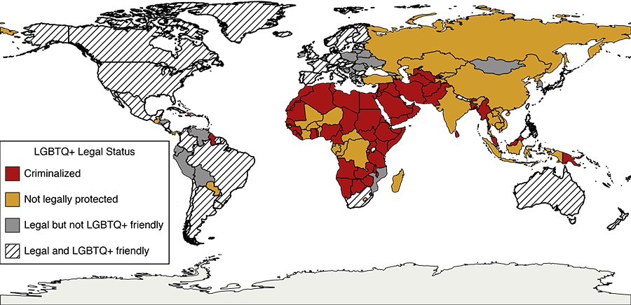
Although the survey asked about many experiences in the geosciences track, we were particularly struck by the data we collected on fieldwork and remote research. When asked about experiences with fieldwork or remote research, almost 55% of respondents indicated that they had been in an area where they did not feel safe because of their identity, expression, or presentation. Furthermore, about a third of the respondents indicated that they have refused to do fieldwork because of concerns for personal safety related to their identity. The need for these concerns becomes clear when looking at a world map highlighting where LGBTQ+ identities are not protected or are even criminalized (Figure 1). Even in places where these identities are not categorized as unlawful, the dominant culture may not be LGBTQ+ friendly.

A map showing areas in the world where LGBTQ+ status is criminalized or not legally protected, as well as countries in which residents do not believe the country is a hospitable place for LGBTQ+ people.
Fig. 1. This map shows areas in the world where LGBTQ+ status is criminalized (red) or not legally protected (yellow), as well as countries in which residents do not believe the country is a hospitable place for LGBTQ+ people. (Individuals in Antarctica are each covered by the laws of their own country.) Credit: Alison N. Olcott

These findings are striking, both in their scale and in how widespread they are. For instance, Clancy et al. [2017] conducted a methodologically similar study of astronomers and planetary scientists identifying those likely to feel unsafe in their workplaces because of gender (women, 35%; men, 1%) and race (women of color, 28%; men of color, 1.5%; white men and women, <1%). Our data show that a majority of individuals in all demographic groups identified by Clancy et al. who also identify as LGBTQ+ have felt unsafe with fieldwork or remote research experiences, and 34% refuse to do fieldwork over fears related to their identity. In fact, 62% of cisgender white men reported feeling unsafe in the field due to their LGBTQ+ identity; the only group that reported feeling more unsafe was cisgender women of color (75%). Cisgender women of all races and transgender people of color reported the highest rates of refusing to do fieldwork because of safety issues (50% and 46%, respectively).

Support Is Lacking for Graduate Students

Another troubling finding of our survey is that LGBTQ+ graduate students (29%) are significantly less likely than professors (57%) to have opted out of fieldwork in a specific locality because of safety fears. This is not surprising given the power imbalances present in graduate programs; a graduate student’s research is often done in consultation with faculty advisers as part of a larger research agenda, which means that relative to faculty, students typically have far less control over their field site selection.

This power imbalance speaks to the need for graduate programs to develop adequate support and mentorship for LGBTQ+ graduate students, a need that is echoed in the survey responses. Most respondents (87%) reported that increased LGBTQ+ mentorship would have been helpful during their time as a student. Responses indicated that faculty support for the LGBTQ+ community was low both inside and outside the classroom, with 85% and 69% of respondents, respectively, reporting rarely or never experiencing such support. These two metrics are correlated: A student who experiences in-class support is likely also to have experienced out-of-class support.

Compounding the lack of available support, the overwhelming majority (85%) of respondents felt that other LGBTQ+ people in geology were not visible during their time as a student, presenting a challenge to them to even seek out and solicit mentorship. An even greater majority (91%) expressed that greater visibility and representation of LGBTQ+ people in geology would have been helpful during their time as a student, both in the field and at their home institution.

Using Data to Support LGBTQ+ Geoscientists

Given that almost all respondents wished for visible representation and that individuals in all demographic groups have felt unsafe doing fieldwork or remote research, it’s clear that existing interventions to make the geosciences more inclusive are not sufficient for LGBTQ+ geoscientists. These findings are key for developing solutions for challenges faced by the LGBTQ+ geoscientist community.

Advisers, employers, and institutions need to be aware of safety issues associated with fieldwork and to educate themselves about potential dangers to LGBTQ+ geoscientists at field sites. However, the need for support and mentorship goes beyond the field [Mulcahy et al., 2016]. In the classroom, support for LGBTQ+ students starts with professors confronting homophobia, using inclusive language, and using students’ preferred pronouns. Out of the classroom, faculty and staff can engage in supportive academic advising, visible allyship, and diversity training. Such gestures may seem small but are, in fact, tremendously meaningful. LGBTQ+ students report that a crucial part of their overall success is having a mentor to whom they are comfortable disclosing their identity.

Over the past few years, the geosciences community has been trying to broaden participation by making fieldwork and conferences more accessible and welcoming. Our survey makes clear that we need to reach out further to explicitly support the LGBTQ+ community. An important place to start is with education and awareness that allow our LGBTQ+ colleagues to be safe and feel supported in the field.

Acknowledgments

The authors thank Patrick Getty, T. K. Morton, Khye Blue, and Colleen Wynn for feedback on the initial survey and A. Bradley for providing additional data. We received approval from the Human Research Protection Program at the University of Kansas (IRB ID: STUDY00144586) for human subject testing for the survey.

References

Clancy, K. B. H., et al. (2014), Survey of academic field experiences (SAFE): Trainees report harassment and assault, PloS One9(7), e102172, https://doi.org/10.1371/journal.pone.0102172.

Clancy, K. B. H., et al. (2017), Double jeopardy in astronomy and planetary science: Women of color face greater risks of gendered and racial harassment, J. Geophys. Res. Planets, 122(7), 1,610–1,623, https://doi.org/10.1002/2017JE005256.

McInroy, L. B. (2016), Pitfalls, potentials, and ethics of online survey research: LGBTQ and other marginalized and hard-to-access youths, Social Work Res.40(2), 83–94, https://doi.org/10.1093/swr/svw005.

Mulcahy, M., et al. (2016), Informal mentoring for lesbian, gay, bisexual, and transgender students, J. Educ. Res.109(4), 405–412, https://doi.org/10.1080/00220671.2014.979907.

Yoder, J. B., and A. Mattheis (2016), Queer in STEM: Workplace experiences reported in a national survey of LGBTQA individuals in science, technology, engineering, and mathematics careers, J. Homosexuality63(1), 1–27, https://doi.org/10.1080/00918369.2015.1078632.

Author Information

Alison N. Olcott (olcott@ku.edu) and Matthew R. Downen, University of Kansas, Lawrence

Citation: Olcott, A. N., and M. R. Downen (2020), The challenges of fieldwork for LGBTQ+ geoscientists, Eos, 101, https://doi.org/10.1029/2020EO148200. Published on 28 August 2020.
Text © 2020. The authors. CC BY-NC-ND 3.0


Record Locust Swarms Hint at What’s to Come with Climate Change

Warming oceans that feed cyclones have also bred record-breaking swarms of desert locusts. Such plagues could grow bigger and more widespread with climate change.

By Rina S. Khan 

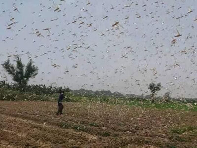
In mid-June, the United Nations Food and Agriculture Organization (FAO) issued a threat level warning to countries across East Africa and southwest Asia: Desert locusts (Schistocerca gregaria) are swarming. A severe outbreak that started in 2019 has spread across the Horn of Africa and the Middle East before moving on to western Asia. Scientists say climate change has played a role in this invasion.

Usually solitary, locusts become gregarious, or swarm, when there are heavy rains in an arid region. Desert locust swarms are highly destructive, sparing no greenery in sight.

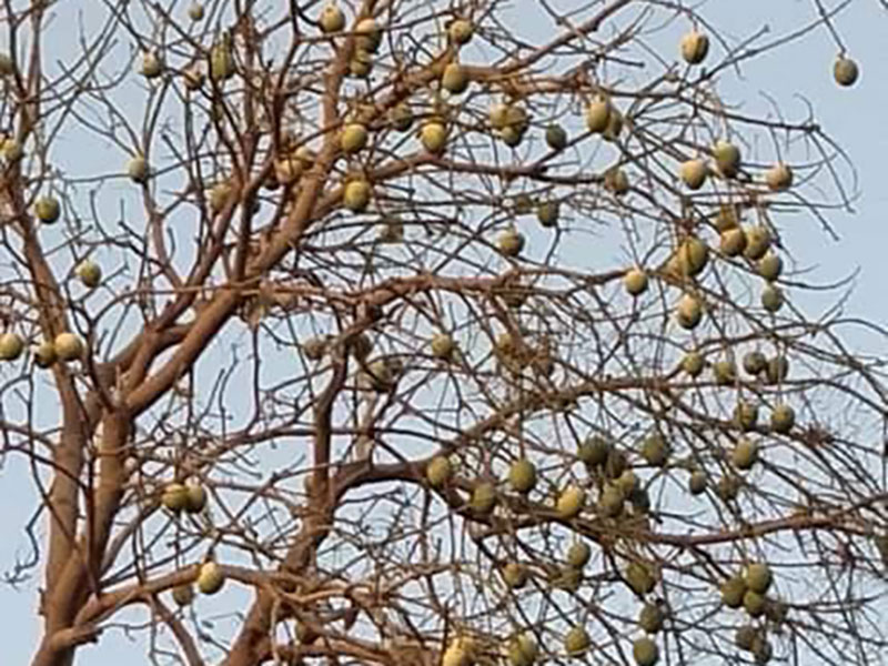
A mango tree is devoid of its leaves, which have been eaten by desert locusts
This mango tree in Hyderabad, Pakistan, is devoid of its leaves, which were consumed by a swarm of desert locusts. Credit: Sarwar Panhwar

This year’s locust attacks, which spread from Kenya to Pakistan and India, are the worst in the past 30 years and may be the most economically destructive since the 1960s, said Chaudhry Inayatullah, a former research scientist at the International Centre of Insect Physiology and Ecology in Nairobi, Kenya. The swarms are expected to peak this month, as a wetter-than-normal monsoon arrives, and to flourish as the rains continue through October.

Inayatullah and other locust experts fear that these attacks will only get worse. Climate change is altering the dynamics of pest control and reproduction, said Keith Cressman, the FAO’s senior locust forecaster. Changes in climate have led to increases in cyclones, which feed locust swarms with water and warmth.

Recent research also shows that human-induced warming may be intensifying a regional variability in an Indian Ocean pattern of warming and cooling called the Indian Ocean Dipole (IOD), sometimes nicknamed the “Indian Niño.” A more intense IOD could cause more frequent tropical storms and heavy rains. These rains create perfect conditions for locust breeding, with more water and warmth ideal for increased plant biomass to feed the locusts—which is what happened in 2019, when a record IOD led to above-average rainfall in the coastal areas of Somalia, Yemen, and some regions bordering the Red Sea.

During droughts, locust outbreaks do not occur in the region, mostly because of a lack of plants for the insects to eat. But higher temperatures associated with climate change coupled with increased availability of plants for food could speed up the locusts’ maturation and incubation during spring, Inayatullah said. This year, warmer temperatures have already allowed an extra generation of breeding to occur in northwest Africa, the Arabian Peninsula, and southwest Asia, amplifying the overall risk of a locust plague, the most serious category of locust threat identified by the FAO.

Perfect Storms for Locusts

“If this trend of increased frequency of cyclones in [the] Indian Ocean continues, then certainly, that’s going to translate to an increase in locust swarms in the Horn of Africa,” said Cressman. An increased number of cyclones in the past 3 years in the Indian Ocean played a role in the current upsurge. “In 2018, two cyclones dumped heavy rain on the uninhabited portion of the Arabian Peninsula known as the Empty Quarter. There, locusts can breed and reproduce freely. Three generations of breeding occurred in 9 months in the Empty Quarter, causing locust numbers to increase by 8,000 times.” Cressman said that outbreak is the source of the East Africa upsurge the FAO is warning about now.

The swarms can jump oceans, and they leapt over the Red Sea and Gulf of Aden to the Horn of Africa late last year. “There, another cyclone in December 2019 triggered yet another spasm of reproduction that could give rise to two more generations of breeding—400 times the locusts,” Cressman said.

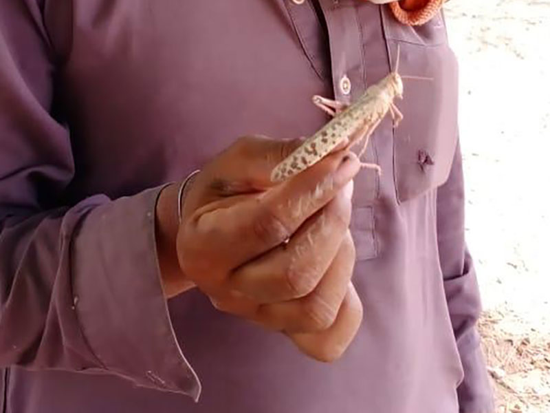
Close-up of a desert locust
Climate anomalies have allowed desert locust populations to have “reproductive spasms” several times this year. Credit: Sarwar Panhwar

Heavy rains in Yemen and Saudi Arabia prompted the spread of locusts into Iran and Pakistan. They have also managed to breed in Pakistan’s Balochistan Province adjacent to Iran, are currently sweeping across the country’s southern agricultural belt, and have entered India across the Rajasthan desert. Drifting with the wind, some individuals have even been captured in Nepal. The FAO says the spring-bred swarms along both sides of the Indian-Pakistan border were poised to mature and lay eggs in early July, and new swarms will arrive from the Horn of Africa in mid-July.

Already, some farmers in Pakistan have reported up to 50% losses of their cotton crops. Ghulam Sarwar Panhwar, who owns two farms on around 120 hectares of land in the Hyderabad District of Sindh, said three locust attacks hit his farm in the past 3 months.

“Each time it is like a black cloud descending from the sky. There are millions of them, and they attack the cotton and other crops, eating all the green leaves in just 3–4 hours’ time before moving on,” Panhwar said. “Half of my cotton crop is gone. We chase them off by beating drums and banging metal plates. What else can we do?”

Aside from eating cash crops, the locusts are also consuming fodder plants, which will affect livestock.

Climate Controls

Meanwhile, the FAO has asked Pakistan and India to remain on high alert. India, Pakistan, Iran, and Afghanistan are all part of FAO’s Commission for Controlling the Desert Locust in South-West Asia. “Intercountry cooperation is needed to tackle the locust threat. Where they fly next depends on wind direction, speed, and other weather parameters,” Inayatullah said.

Man holds a large locust between forefinger and thumb in a village near Hyderabad
A farmer holds one locust out of the thousands that have ravaged crops in Pakistan. Credit: Sarwar Panhwar

Accurate wind forecasts could be helpful to understand possible new landing sites, where aerial and ground spraying operations for pesticide applications could be readied in advance. Spraying in desert breeding areas in Pakistan has been underway since February, the region’s early spring, and could have its own set of ecological impacts.

The locust swarms eventually will dwindle in the cooler and drier winter months. No longer gregarious, “they will change back to their solitary phase,” Inayatullah said, “but by then they would have spread over vast areas and would have enough fat in them to stay alive even without food—until warmer weather arrives. This would be the ideal time to monitor and control them.”

—Rina Saeed Khan (@rinasaeed), Science Writer

Citation: Khan, R. S. (2020), Record locust swarms hint at what’s to come with climate change, Eos, 101, https://doi.org/10.1029/2020EO146954. Published on 14 July 2020.
Text © 2020. The authors. CC BY-NC-ND 3.0