Thursday, December 30, 2021

CALDERA CHRONICLES

Caldera chronicles: Why drilling the Yellowstone volcano to stop eruptions or generate power is a bad idea

Dec 24, 2021

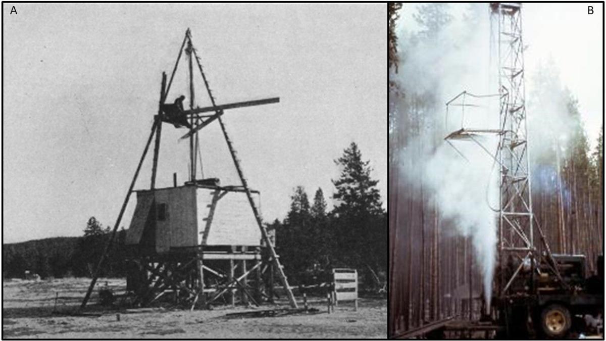
Research drilling in Yellowstone National Park. (A) is an image from Fenner (1936) of the drilling setup in the Upper Geyser Basin during the 1929 field season. (B) is an image from White et al. (1975) of the USGS drill rig set up in the Norris Geyser Basin in 1967-68 during a steam eruption.

Courtesy photos


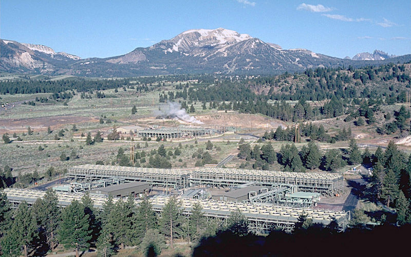
Mammoth Mountain, on the edge of Long Valley caldera (California), is the dominant peak on the skyline, and the jagged peaks to the right of Mammoth Mountain are the Minarets. The Casa Diablo Hot springs are just beyond the power facility along the western edge of a down-faulted block at the southwestern margin of the caldera’s resurgent dome. The low ridge in the middle right of the photo marks the western edge of the down-faulted block.

Yellowstone Caldera Chronicles is a weekly column written by scientists and collaborators of the Yellowstone Volcano Observatory. This week's contribution is from Michael Poland, geophysicist with the U.S. Geological Survey and scientist-in-charge of the Yellowstone Volcano Observatory.


It’s a common question – why not just drill into Yellowstone to relieve the pressure? And it seems like a reasonable idea given the way that magma chambers are often depicted: as caverns of expanding liquid magma that just need to be tapped, like letting air out of a balloon.

Magma reservoirs are much more complex than this simple depiction, however. Instead of huge balls of liquid magma, they are a mushy mix of rock, melt, crystals and various fluids and gases, with poor interconnectivity and often no sharp boundary between the reservoir and the surrounding rock.

Yellowstone provides an excellent example. Seismic imaging techniques (like taking an MRI of the Earth) have revealed two huge magma reservoirs beneath the caldera system: one at 5–17 kilometers (3–10.5 miles) beneath the surface, and a deeper one at 20–50 kilometers (12.5–31 miles). The speed of seismic waves through these reservoirs suggests they are mostly solid – the upper reservoir appears to be only 5-15% molten, and the deeper 2-5% molten.

Pressure within this type of system is not like air in a balloon, and it cannot be easily dissipated by poking a hole, or even a hundred holes, into the complex structure. Within a magmatic system, pressure accumulates because magma and associated fluids are accumulating. It would be as if a balloon were filling with mostly solid cement, with some poorly connected regions that were wet and contained some gases. Poking a hole in that balloon would not cause the cement to disappear, nor would it reach all parts of the poorly connected “wet” part of the system. Moreover, the drill holes intended to tap the gases in a magma reservoir would plug shut with dense taffy-like magma without constant intervention.

But what about cooling the magma reservoir by pumping water into the subsurface? This was the subject of a 2015 report by Jet Propulsion Laboratory engineers, who calculated that the magma chamber could be cooled if a sufficient supply of water were pumped through the subsurface over the course of thousands of years, generating geothermal energy in the process.

While this proposal might seem to make some sense, the calculation overlooked a number of complicating factors. For example, the hotspot fueling volcanism at Yellowstone provides a steady supply of heat. Cooling the magma body by pumping water into the subsurface would be like attempting to cool a pot of boiling water by steadily adding droplets of cold water but leaving the burner on.

For all of these magma quenching and tapping concepts, there is also the issue of unintended consequences. Rapid depressurization and freezing are factors that can drive magma toward the surface by stimulating dissolved gases to come out of solution – like opening a can of soda or putting a can of soda in the freezer (please don’t try this unless you enjoy cleaning up messes!) – so attempts at cooling and depressurizing magma systems might even make an eruption more likely.

But what about power generation, which usually involves drilling into areas often near magma reservoirs and extracting hot water that becomes steam and can be used to drive turbines? Geothermal power is used in many places worldwide – in Iceland, it accounts for about 30% of all power generated in the country.

Geothermal power exploitation in Yellowstone, however, is illegal by act of Congress – the Geothermal Steam Act of 1970 (amended in 1988). This act requires the Department of Interior to preserve and monitor hydrothermal features, like Old Faithful, in units of the National Park Service. There is a good reason the law exists. In many places – including California, Nevada, Chile, New Zealand, and Iceland – geothermal power production has altered the behavior of nearby hydrothermal features. There is still quite a lot we don’t understand about how water moves beneath the surface in the Yellowstone area, and it is likely that even geothermal development outside the park would impact features within the park.

Drilling does have a role to play, however, in better understanding how volcanoes work, including at Yellowstone. In 1929-30, and again in 1967-68, limited drilling was done in some of the geyser basins of the park, to a maximum depth of about 330 meters (1,080 feet), to better understand the shallow hydrothermal system. And in 2007-08, boreholes up to about 250 meters (820 feet) deep were drilled in several locations to host sensitive monitoring instruments. These studies have been invaluable in better understanding how Yellowstone’s hydrothermal and magmatic systems work.

At other volcanoes, drilling has accidentally penetrated active magma bodies. In 2005, drilling in Hawaii encountered magma along the East Rift Zone of Kīlauea Volcano. The hole rapidly closed as liquid magma flowed in and froze. A similar process occurred when magma was unexpectedly encountered during drilling at Krafla volcano, Iceland, in 2009, and in Kenya in 2011. These encounters have motivated a research project – an international magma observatory – that aims to drill into the magma body at Krafla that was encountered in 2009, and to install equipment that will help scientists better understand the conditions in and around magma reservoirs.

Drilling has an important role to play in better understanding and monitoring volcanoes, and in some places it can be a means of generating geothermal power. But as a means of stopping or slowing an eruption, drilling is very unlikely to be helpful. In any case, there is no concern of impending eruptive activity at Yellowstone, so drilling to stop an eruption is an example of a non-solution for a non-problem.
NZ
Mud volcano erupting on Gisborne farm threw large rocks 50 metres


Marty Sharpe
Dec 20 2021

A mud volcano that burst to the surface on a farm near Gisborne threw large rocks 50 metres and is continuing to “bubble away”, 10 days after it erupted.

Gisborne District Council scientist Murry Cave​ said the mud volcano appeared on Monowai Station in the head of the Waimata Valley, about 25km north of Gisborne, about 7.45pm on December 10.

“It was accompanied by a sound that the landowners initially thought was thunder,” Cave said.

He said mud volcanoes were a natural but rare phenomenon in New Zealand, and Gisborne/Tairawhiti had quite a few. This latest one is about 2km from the last mud volcano eruption in the area, which occurred in December 2018.


MURRY CAVE
The mud volcano on Monowai Station spewed large rocks 50metres.

“This latest one is a bit smaller than that one. It happened over about an hour, but is still bubbling away. There's quite a bit of bubbling going on, but it’s not ejecting any more mud at this stage,” he said.

This mud volcano is on farmland a long way from any houses or structures, unlike the 2018 one, which was only 150 metres from the nearest house.

“Despite their name, they are not related to volcanoes or to geothermal mud pools such as at Rotorua. Instead, they relate to faults and often have a delayed reaction to major earthquakes. This event is probably a delayed response to the March 5th Te Araroa earthquake,” Cave said.


MURRY CAVE
The mud volcano near Gisborne.

Mud volcano eruptions eject gas, water and rocks into the air “and in this instance quite large rocks were thrown around 50m clear of the mud volcano itself”, he said.

“The rocks ejected can come from many kilometres underground and is generally a mix of many types of rocks not typically seen at the surface.

“The gas associated with the mud volcano is dominated by methane, but can include other gases such as ethane, propane and butane. Sometimes, there is oil associated with such eruptions but not in this case.”
Kilauea Volcano Summit Eruption Resumes Overnight

image from USGS webcam at night showing the west vent in Halemaʻumaʻu crater

by Big Island Video News
on Dec 28, 2021 

STORY SUMMARY


HAWAIʻI VOLCANOES NATIONAL PARK - The summit eruption of Kīlauea Volcano resumed on Monday evening, ending a 2-day pause in activity.


thermal image from USGS webcam showing Halemaʻumaʻu and lava lake

(BIVN) – Kilauea volcano is again erupting lava at the summit in Halemaʻumaʻu crater, ending a two-day pause in eruptive activity.

“New breakouts on the surface of the Halemaʻumaʻu lava lake appeared at 7:10 PM last night following a resumption of strong volcanic tremor around 6:50 PM,” reported the USGS Hawaiian Volcano Observatory on Tuesday morning. “About half an hour after the lava breakouts appeared, the summit began to deflate, reversing the strong inflationary episode of the prior day leading up to the return of eruptive activity.”

Lava lake activity “resembles that observed prior to the recent eruptive pause”, the scientists say, and remains confined within Halemaʻumaʻu crater in Hawaiʻi Volcanoes National Park.

“There are no indications of activity migrating elsewhere on Kīlauea,” the USGS said. “No unusual activity has been noted in the Kīlauea East Rift Zone.”

From the Tuesday’s USGS Halemaʻumaʻu lava lake observations:

New breakouts of lava began issuing from the western vent in Halemaʻumaʻu at 7:10 PM last night. The renewed input of lava has rejuvenated the lava lake that was active prior to the recent eruptive pause, occupying the same footprint as before. However, the newly reactivated lake has also been overflowing and feeding substantial lava flows to the north and south over inactive, crusted portions of the lake surface. The lake has seen a total rise of about 70 meters (230 feet) since lava emerged on September 29. Measurements from a helicopter overflight on December 21 indicated that the total lava volume effused since the beginning of the eruption was approximately 38 million cubic meters (10.0 billion gallons) at that time.

The Kilauea USGS Volcano Alert Level remains at WATCH, and the current Aviation Color Code remains at ORANGE.
How a volcano and flaming red sunsets led an amateur scientist in Hawaii to discover jet streams

The eruption of Krakatoa in 1883 sent volcanic dust and gases circling the Earth, creating spectacular sunsets captured by artists. William Ashcroft via Houghton Library/Harvard University

On the evening of Sept. 5, 1883, people in Honolulu witnessed a spectacular sunset followed by a period of extended twilight described as a “singular lurid after sunset glow.” There were no signs of anything else out of the ordinary, but these exceptional twilight glows returned each morning and evening over the following weeks.

Among the mystified Honolulu citizens was 56-year-old Rev. Sereno Edwards Bishop, who in his varied career in Hawaii had been a chaplain, school principal and surveyor, and who had a keen interest in science. Over the subsequent weeks and months, the exceptional twilight glows occurred around the whole globe. Remarkably, as scientists first grappled with understanding the origin of the twilight glows, Bishop’s efforts would lead to the first convincing explanation.

Rev. Sereno Edwards Bishop (1827–1909) Wikipedia

His discoveries led to scientific investigations of the winds high above the ground and ultimately yielded information that today is used to forecast weather over extended periods.

I am a meteorologist in Hawaii who helped revive appreciation of Bishop’s seminal contribution to the scientific exploration of the upper atmosphere.
A volcanic eruption half a world away

Today we know that the 1883 glows were caused by the sun below the visible horizon illuminating a mist of small liquid droplets in the atmosphere high above the ground.

The mist was made of sulfuric acid droplets that were formed by reactions of the massive amounts of sulfur dioxide gas produced by the explosive eruption of Mount Krakatoa close to the equator in Indonesia on Aug. 27, 1883. The eruption sent the droplets high into the atmosphere, where the winds transported them around the world. They spread gradually, and it was November before people in London began to notice the glow.

Much later, scientists observed similar effects after the June 1991 eruption of Mount Pinatubo in the Philippines. The material Pinatubo injected into the upper atmosphere could be followed in detail with satellite observations, and their connection with spectacular sunsets and twilight glows was clearly established.

Sketches of twilight and afterglow on one evening in 1883 in London following the Krakatoa eruption. William Ashcroft via Houghton Library/Harvard University

In 1883, Bishop had no idea that there had been a volcanic eruption until the San Francisco newspapers arrived. Very quickly, he formulated a hypothesis that he published as a letter in his local newspaper.

“I am disposed to conjecture that some very light element among the vapors of the Java eruptions has continued at a very great height in the atmosphere, and has been borne … across the Pacific into this region,” Bishop wrote.

He realized that he could connect the eruption to the glowing skies most credibly by gathering reports of the first appearance of the glows elsewhere and tracking the initial spread of the “vapor” from Krakatoa. Bishop continued his letter: “I earnestly invite, in behalf of science, all shipmasters and mates to publish what they may have observed at sea.”

Bishop assembled a dozen such reports over the first three weeks after the eruption and was able to show that the “vapor” that produced the glows had moved westward from Krakatoa, along the equator to reach Honolulu 10 days later. This implied that there was a wind high in the atmosphere blowing steadily with an extreme speed that, at ground level, is seen only in hurricanes.

Tracking the red sunsets following the Krakatoa eruption. The stars mark the initial reports and dates of seeing the exceptional twilight colors in 1883.

Bishop published his observations in The Hawaiian Monthly, concluding that there was “a vast stream of smoke due west with great precision along a narrow equatorial belt with an enormous velocity, around the globe.”

The equatorial jet stream


Bishop called the motion of the volcanic aerosol a “smoke stream.” In fact, the equatorial winds transporting the aerosol were the first discovery of what meteorologists now call a jet stream.

A half-century would pass before the experiences of pilots flying at heights of several miles revealed the existence of the extratropical jet streams lower down in the atmosphere that are now familiar from TV newscasts. Jet streams are strong, typically narrow bands of wind. The more familiar lower atmospheric jet streams move weather systems in the middle latitudes from west to east. By contrast, Bishop’s jet stream circles the equator at high altitudes and actually can blow from east to west.

Bishop’s work opened further exploration of the equatorial jet stream that culminated in the 1961 discovery that the equatorial jet stream varied from strong east winds to strong west winds roughly every other year. This so-called Quasi-biennial Oscillation has been shown to connect with weather near the ground, particularly in Europe and the North Atlantic, a fact that is now routinely exploited in making long range forecasts for the weather.

Bishop’s contribution was acknowledged by the scientists who first followed him, and he won a prize from New York’s Warner Observatory in a contest for essays explaining the post-Krakatoa glows. Bishop even merited a brief obituary in an American meteorological science journal.

Bishop, who was the son of missionaries, could also be a divisive figure in Hawaii. He supported the U.S. annexation of the islands, and his religious views opposed some native Hawai'ian traditions, such as the hula dance. His contributions to science were largely forgotten in the 20th century.

An international scientific committee’s celebration of the 60th anniversary of the Quasi-biennial Oscillation discovery is an opportunity to remember Bishop and his discovery.

August 16, 2021
Author
Kevin Hamilton
Emeritus Professor of Atmospheric Sciences, University of Hawaii
How Do You See Inside a Volcano? Try a Storm of Cosmic Particles.

Muography, a technique used to peer inside nuclear reactors and Egyptian pyramids, could help map the innards of the world’s most hazardous volcanoes.


Volcanic lightning over Mount Sakurajima as it erupted in Kagoshima prefecture, Japan, 
in December. Researchers have used muography to peer inside.
Credit...Kyodo, via Reuters

By Robin George Andrews
Nov. 10, 2021

The next time the sun is shining, go outside. There may not be a cloud in the sky, but you will be standing in the middle of a spectral rainstorm.

Cosmic rays, emanating from all sorts of high-energy entities, constantly bombard Earth’s atmosphere. Their collisions with gases make tiny particles named pions, which speedily decay into muons, subatomic blobs more than 200 times heavier than electrons. Trillions of muons are shooting toward the ground at close to the speed of light every single second.

When muons encounter an object, some pass right through while others get stopped in their tracks. That means muons can be used to see inside things that would otherwise be inaccessible, from nuclear reactors to the depths of Egypt’s pyramids.

Scientists have long suspected that this technique, named muography, could be applied to volcanoes, whose anatomies determine when and how they will erupt. And researchers show in a paper, published Wednesday in the Proceedings of the Royal Society A, that muons have been used to successfully map out some of the arteries and organs of volcanoes across the world, including some of the world’s most hazardous magmatic mountains.

One day, volcanic muography could become the “ultimate detection system for magma,” said Giovanni Leone, a geophysicist at the University of Atacama in Chile and the study’s lead author. He and his colleagues say if you can use muons to track the movement of molten rock in real time, you should be able to forecast when an eruption is about to transpire.

When muons zip through material, their momentum is sapped. The denser the material is, the more likely these muons will lose all their energy, grind to a halt and decay into neutrinos and electrons.

Objects are rarely equally dense throughout. That includes volcanoes, which are made of either magma-filled or vacant passageways, a diversity of rock types and countless cracks, crevasses and chasms. To perceive these features, volcanologists could use muon detectors, which range from the size of a suitcase to the area of a small apartment. Scientists could place detectors around a volcano’s flanks, or even fly one around the volcano with a helicopter.

A multi-wire proportional chamber-based muography observation system in the Sakurajima Muography Observatory.
Credit...Leone et al., Proceedings of the Royal Society A, 2021


The endless muon rainstorm will shower the volcano at an angle. Some of the muons passing through one side of the volcano’s flanks will reach detectors on the other side; those that don’t will cast subatomic shadows on the detectors, revealing which parts of the mountain’s insides are denser and which are more vacuous.

With one detector, you can get a two-dimensional image of a volcano’s innards, “similar to a medical X-ray,” said David Mahon, a muography researcher at the University of Glasgow who was not involved with the study. “By using multiple detectors positioned around the object, it’s possible to build up a crude 3-D image.”

After using muography to see inside an innocuous Japanese mountain in 1995, the technique was eventually deployed at active volcanoes. One of the first successful campaigns was Mount Asama in Japan, where researchers found a buried lava mound sitting atop a Swiss cheese-like magmatic passageway. It has since been used to see into, among others, Italy’s Etna and Stromboli volcanoes, Japan’s hyperactive Sakurajima volcano and the La Soufrière de Guadeloupe volcano in the Caribbean.

Muons have found weaknesses that hint at the site of future flank collapses, landslides and lava escape routes. They have also found fresh pockets of magma that may be primed to erupt and that were overlooked by other instruments.

Volcanic muography isn’t flawless. The detectors can only see the parts of the volcano that the muons are penetrating. “You can only watch from below towards the sky,” said Marina Rosas-Carbajal, a volcano geophysicist at the Paris Institute of Earth Physics who was not involved with the study. Muons are unable to penetrate deeper parts of the volcano, leaving those areas largely off-limits to muographers.

Placing detectors around dozens more volcanoes, and subjecting volcanic rocks to muons in laboratories, will improve the technique’s precision as it vies for mainstream use. But even if it does become commonplace, it won’t solve all our volcanic woes.

“Volcanoes are super complex,” said Dr. Rosas-Carbajal. Their labyrinthine innards and complex chemistries mean their magma will occasionally evade even the savviest of detectors. Unpredictable eruptions will remain a fact of life, no matter how well scientists wield the magic of muons.

And muography is unlikely to make obsolete the other various instruments used to study volcanoes, like seismic waves and satellite observation. “It may not replace existing techniques,” said Vitaly Kudryavtsev, a particle physicist at the University of Sheffield who was not involved with the study. “But it may complement them.”


We’re Barely Listening to the U.S.’s Most Dangerous Volcanoes
Sept. 9, 2019


A version of this article appears in print on Nov. 16, 2021, Section D, Page 2 of the New York edition with the headline: Molten Innards: To Get a Glimpse Inside a Volcano, Think Cosmically.


Inner Workings: The hidden lives of volcanic plumes provide clues about eruption activity

 See all authors and affiliations

Volcanoes can pave their surroundings with lava, send clouds of hot ash downslope to smother cities, and even generate massive tsunamis. The most recent high-profile eruption on the Canary Islands spawned viral videos of slow, steady folds of smoldering lava enveloping houses and swimming pools.

But the perils volcanoes pose aren’t limited to ground level: Their ash plumes threaten aircraft passing overhead, even those flying at cruise altitude. In the case of a sudden and explosive eruption, those clouds of ash—which are in fact small bits of rock—can reach elevations of 10,000 meters in just a few minutes.

Despite these impressive displays, volcanic eruptions, especially remote ones situated far away from seismic instruments, can be hard to detect. There are some clues: Plume-induced lightning often betrays the presence of ash clouds once they’ve reached high altitude. But recent studies suggest that a different kind of electrical discharge—one generated near the base of a volcanic plume and nowhere else—could provide researchers with a heads-up that an eruption has commenced. Another analysis hints that other unseen signals, the low-frequency warbles known as infrasound, could help researchers monitor changes in ongoing eruptions that signal danger for people nearby.

Danger in the Air

Dozens of aircraft have had run-ins with plumes of volcanic ash, although none of these encounters has been fatal. One of the most dramatic encounters occurred in December 1989 when KLM flight 867 from Amsterdam ran into an ash cloud as it approached its destination in Anchorage, AK. Ash sandblasted the plane’s windshields; airspeed sensors began to give false readings and then failed. All four engines died; the plane lost more than 3 kilometers of altitude before pilots could restart them. Although the pilots landed the 747 safely, it took more than $80 million to replace the engines and rehab the plane.

The eruption of a volcano on the Canary Island of La Palma, in Todoque, Spain, seen here in late September, is the latest volcanic event to cause widespread destruction and garner worldwide media attention. Image credit: Reuters/Nacho Doce (photographer).

Researchers have long noted that many volcanic plumes, especially large ones, generate lightning. And strokes of lightning—especially the long, powerful ones—are often detected by the same network of sensors that meteorologists use, explains Stephen McNutt, a volcanic seismologist at the University of South Florida in Tampa. As a result, this lightning has often served as a sign of an eruption. Of course, that lightning could just as easily serve as a sign of a garden-variety thunderstorm.

But volcanoes produce other sorts of electrical discharges too—some of which are, as far as researchers know, unique to volcanoes, says McNutt. In recent years, this type of lightning has intrigued researchers.

All Charged Up

Whatever the type of discharge, it stems from phenomena taking place at the base of the ash plume. There, ash particles get electrically charged in two ways. One occurs when the particles first form. As molten rock spews into the air at high speed, it breaks into droplets, just as a turbulent stream of water from a garden hose does. Although the torrent of molten rock starts out electrically neutral overall, individual particles of ash that solidify can end up either positively or negatively charged as they break apart, occasionally carrying unequal numbers of charges with them. A second way that ash particles get charged is by rubbing against each other at high speed—a geological version of shuffling one’s shoes on the carpet.

Lab studies have suggested that larger particles of ash tend to gain positive charges, whereas smaller ones end up negatively charged (1). And in the chaotic jumble of an ash plume, those charged particles can get separated. Researchers found that smaller particles tend to end up on the periphery of the plume, whereas the large ones tend toward the center. Also, lighter, negatively charged particles are buoyed more effectively than the heavier, positively charged ones. In portions of the plume far from the volcano, charges can spread far apart, says McNutt. At the base of the plume, charged particles are necessarily close together. Regardless of the distance, however, electrical fields can grow only so strong before they overwhelm the air’s ability to prevent discharges.

At distances of one kilometer or more from the volcano, researchers have noted, these discharges typically take the form of full-fledged lightning bolts that can extend several kilometers or more. The discharges also generate brief yet prodigious pulses of radio waves—which anyone who listens to AM radio near a thunderstorm can recognize as loud bursts of static. Large numbers of aptly named “vent discharges” occur much closer to the volcano at the base of an ash plume and generate a near-constant crackle of radio waves, which researchers have dubbed continual radio frequency (CRF) emissions. In 2014, McNutt and a colleague described how lightning observations, both of large bolts and CRF, could be used to monitor volcanic eruptions (2). Whereas large bolts emit a lot of low-frequency energy and can be detected over long distances, says McNutt, CRF emissions occur at higher frequencies and can only be discerned by line-of-sight observations.

Since then, researchers have learned much more about volcanic lightning. Field work around Japan’s Sakurajima volcano in 2015 showed that individual CRF discharges are extremely brief, typically lasting no longer than 160 nanoseconds—which, in turn, indicates that the discharges extend no more than 10 meters (3). Subsequent analyses of data gathered during 97 small eruptions from the volcano during one 7-day stretch showed that, in general, lightning bolts were generated at higher altitudes during eruptions that spewed a lot of material (4). CRF emissions, on the other hand, were generally produced during high-speed eruptions at altitudes much closer to the vent, says Cassandra Smith, a geoscientist at the Alaska Volcano Observatory in Anchorage.

Although CRF discharges are readily betrayed by their radio emissions, it’s not clear whether they’re visible or not. No one has captured any of them in photos or on video, says Smith—the discharges are small, brief, and likely almost always well hidden inside the ash-rich plume.

Because these mysterious CRF emissions occur at the base of volcanic ash plumes and nowhere else, they could play an important role in providing early warning for explosive eruptions. Lightning detectors that are set up within 100 kilometers of an erupting volcano and have a direct line of sight to the peak should be able to detect CRF, Smith notes.

The ultimate goal is to use existing networks of seismic and other instruments to guide researchers’ placement of CRF sensors near peaks that show initial signs of rumbling to life, says Alexa van Eaton, a volcanologist at the Cascades Volcano Observatory in Vancouver, WA. Detecting CRF emissions would signify the beginning of an eruption, and if those signals continue for a lengthy period, this would suggest that an ash plume may be rising to altitudes where aircraft fly.

The Sound of Silence

Erupting volcanoes have another intriguing, hidden characteristic that may not only provide insight into eruptions but perhaps also help researchers monitor ongoing volcanic activity. Eruptions produce prodigious amounts of infrasound—frequencies that lie below 20 Hertz, the threshold below which the human ear can’t detect sound. Nevertheless, these warbles can provide researchers with plenty of clues about what’s going on in or near an erupting volcano.

In late 2016 and early 2017, an undersea volcano in the Aleutian Islands erupted more than 70 times over the course of 9 months. Owing to the lack of seismometers on the submerged peak, researchers at the Alaska Volcano Observatory depended on infrasound data, gathered at six sites ranging from 59 to more than 800 kilometers from the peak, to monitor its activity, says Matthew Haney, a geophysicist at the facility. Unlike the radio waves generated by lightning and other discharges, infrasound travels relatively slowly: It took about 3 minutes for sound to travel from the volcano to the nearest array of microphones. And as a result of varying weather conditions and wind speeds, none of the eruptions was detected by all six infrasound arrays, Haney notes.

But the team’s observations nevertheless yielded first-of-their-kind insights into Bogoslof’s volcanic activity. Early in the series of eruptions, when the peak lay beneath several tens of meters of seawater, infrasound generated by the eruptions was dominated by frequencies between 0.1 and 1 Hertz, the researchers reported (5). That low-frequency infrasound largely stemmed from the growth, oscillation, and rupture of giant gas bubbles as they broke the surface of the sea, says Haney. But after the peak breached the surface of the ocean, eruptions spewing directly into the atmosphere generally produced higher-frequency infrasound.

“We can learn a lot about the processes going on inside ash plumes even for small eruptions. But for now, the part we want to know is right outside our grasp.”

—Stephen McNutt

Field work at Italy’s Stromboli volcano during eruptions in 2018 and 2019 has reinforced the utility of sonic observations. There, a team used high-speed video and recording of low-frequency sound, as well as infrasound, to study vortex rings within an ash plume generated by sudden bursts of volcanic activity (see, for example, https://www.youtube.com/watch?v=2vUIzcvkaec). These swirling, doughnut-shaped vortices look something like the smoke rings puffed toward the ceiling by a cigarette smoker, explains Jacopo Taddeucci, a volcanologist at Italy’s National Institute of Geophysics and Volcanology in Rome.

Altogether, the team analyzed 26 vortex rings. Using data captured at speeds up to 1,000 frames per second, the researchers could pin down the position of flying lava blobs within a couple of centimeters or less, says Taddeucci. By pairing these data with images gathered by a drone flying over the peak, the researchers found that they could use the smoke ring data alone to estimate both the diameter of the vent as well as the speed of material spewing from it—and this can then be used to estimate the distance that lava bombs might travel from the vent (6).

Besides providing a better understanding of the basic physics of volcanoes, the new findings can improve safety for researchers as well as tourists hiking near an erupting peak, says Taddeucci. When there are people nearby, he notes, “it is important to notice changes in eruptions very quickly.”

Regardless of whether researchers focus on volcanic lightning or infrasound, “we need more field data from more eruptions,” says McNutt. That, in turn, will require more active peaks to be surrounded by broader networks of sensors of all types, he notes.

Published under the PNAS license.

I’ll Drink to That: Erin and the Volcano

 
I'LL DRINK TO THAT
Episode 488 of I’ll Drink to That! features a tour of Pico Island, a part of the Azores archipelago in the Atlantic Ocean. Erin Scala leads the audio tour and takes listeners along as she speaks with numerous people living and working on the island.

Erin Scala packs big, sturdy boots and heads to Pico Island, a land known for mysterious and intricate vineyard sites, razor-blade lava stones, whale watching, a marshmallow-like cheese, spiritual soups, “The Year of the Noise”, and one particularly giant volcano. As she travels across the island she comes across some distinctive indigenous grape varieties, a wide range of wine styles, and a full-blown, dynamic wine renaissance reverberating across the whole place. Indeed, numerous newly formed and revitalized wineries have come onto the scene on Pico. She also tracks down the history of why winemaking on the island, which had once been producing on a massive scale, dwindled and seemingly faded away until only recently. While discussing Pico, Erin gives a clear sense of her own fondness for it, as well as a compelling case for why you should be paying more attention to the wines and the cultural history they are a part of. If you want to head out into parts unknown and engage with a mysterious landscape, but can’t because of travel woes, let Erin be your guide for this one-of-a-kind tour.

Episode 488 features commentary from (listed in order of appearance):
Vanda Supa, Director of Environment and Climate Change of Pico
Monica Silva Goulart, Architectural Expert of the Pico Island Vineyards
Paulo Machado, Insula and Azores Wine Company
Dr. Joy Ting, Enologist at the Winemaker’s Research Exchange
António Maçanita, Azores Wine Company
Catia Laranjo, Etnom
André Ribeiro and Ricardo Pinto, Entre Pedras
Lucas Lopez Amaral (translated by Paulo Machado), Adega Vitivinícola Lucas Amaral
Tito Silva (translated by Fortunato Garcia), Cerca dos Frades
Jose Eduardo and Luisa Terra, Pocinho Bay
Fortunato Garcia, Czar Winery
Bernardo Cabral, Picowines Co-op
Filipe Rocha, Azores Wine Company
Christina Cunha (for her uncle Leonardo da Silva), Santo Antonio Carcarita
Marco Faria, Curral Atlantis Winery

Photo above by Erin Scala.