Monday, October 10, 2022


The wild weather of La Niña could wipe out vast stretches of Australia's beaches and sand dunes
The wild weather of La Niña could wipe out vast stretches of Australia's beaches and sand dunes
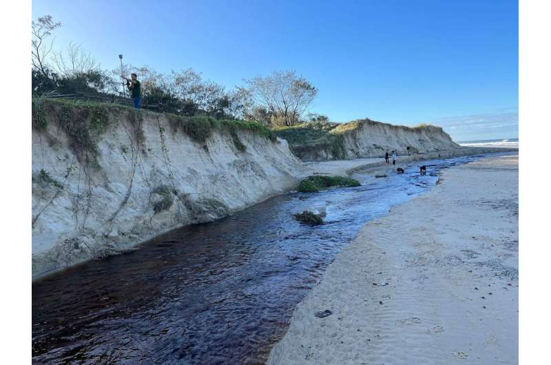
Dune scarps at a beach in Noosa. Credit: Javier Leon, Author provided

Australians along the east cost are bracing for yet another round of heavy rainfall this weekend, after a band of stormy weather soaked most of the continent this week.

The Bureau of Meteorology has alerted southern inland Queensland, eastern New South Wales, Victoria and northern Tasmania to ongoing flood risks, as the rain falls on already flooded or saturated catchments.

This widespread wet weather heralds Australia's rare third back-to-back La Niña, which goes hand-in-hand with heavy rain. There is, however, another pressing issue arising from La Niña events: .

The wild weather associated with La Niña will drive more  along Australia's east coast—enough to wipe out entire stretches of beaches and dunes, if all factors align. So, it's important we heed lessons from past storms and plan ahead, as  will only exacerbate future coastal disasters.

How La Niña batters coastlines

La Niña is associated with warmer waters in the western Pacific Ocean, which increase storminess off Australia's east coast. Chances of a higher number of tropical cyclones increase, as do the chances of cyclones traveling further south and further inland, and of more frequent passages of east coast lows.

Australians had a taste of this in 1967, when the Gold Coast was hit by the largest storm cluster on record, made up of four cyclones and three east coast lows within six months. 1967 wasn't even an official La Niña year, with the index just below the La Niña threshold.

Such frequency didn't allow beaches to recover between storms, and the overall erosion was unprecedented. It forced many local residents to use anything on hand, even cars, to protect their properties and other infrastructure.

Official La Niña events occurred soon after. This included a double-dip La Niña between 1970 and 1972, followed by a triple-dip La Niña between 1973 and 1976.

These events fueled two cyclones in 1972, two in 1974 and one in 1976, wreaking havoc along the entire east coast of Australia. Indeed, 1967 and 1974 are considered record years for storm-induced coastal erosion.

Studies show the extreme erosion of 1974 was caused by a combination of large waves coinciding with above-average high tides. It took over ten years for the sand to come back to the beach and for dunes to recover. However, recent studies also show single extreme storms can bring back considerable amounts of sand from deeper waters.

La Niña also modifies the direction of waves along the east coast, resulting in waves approaching from a more easterly direction (anticlockwise).

This subtle change has huge implications when it comes to erosion of otherwise more sheltered north-facing beaches. We saw this during the recent, and relatively weaker, double La Niña of 2016–18.

In 2016, an east coast low of only moderate intensity produced extreme erosion, similar to that of 1974. Scenes of destruction along NSW—including a collapsed backyard pool on Collaroy Beach—are now iconic.

This is largely because wave direction deviated from the average by 45 degrees anticlockwise, during winter solstice spring tides when  are higher.

Ongoing flood risk for eastern Australia. Credit: Bureau of Meteorology.

All ducks aligned?

The current triple-dip La Niña started in 2020. Based on Australia's limited record since 1900, we know the final events in such sequences tend to be the weakest.

However, when it comes to coastal hazards, history tells us smaller but more frequent storms can cause as much or more erosion than one large event. This is mostly about the combination of storm direction, sequencing and high water levels.

For example, Bribie Island in Queensland was hit by relatively large easterly waves from ex-Tropical Cyclone Seth earlier this year, coinciding with above-average high tides. This caused the island to split in two and form a 300-meter wide passage of seawater.

Further, the prolonged period of easterly waves since 2020 has already taken a toll on beaches and dunes in Australia.

Traditionally, spring is the season when sand is transported onshore under fair-weather waves, building back wide beaches and tall dunes nearest to the sea. However, beaches haven't had time to fully recover from the previous two years, which makes them more vulnerable to future erosion.

Repeated elevation measurements by our team and citizen scientists along beaches in the Sunshine Coast and Noosa show shorelines have eroded more than 10m landwards since the beginning of this year. As the photo below shows, 2–3m high erosion scarps (which look like small cliffs) have formed along dunes due to frequent heavy rainfalls and waves.

On the other hand, we can also see that the wet weather has led to greater growth of vegetation on dunes, such as native spinifex and dune bean.

Experiments in laboratory settings show dune vegetation can dissipate up to 40–50% of the water level reached as a result of waves, and reduce erosion. But whether this increase in dune vegetation mitigates further erosion remains to be seen.

A challenging future

The chances of witnessing coastal hazards similar to those in 1967 or 1974 in the coming season are real and, in the unfortunate case they materialize, we should be ready to act. Councils and communities need to prepare ahead and work together towards recovery if disaster strikes using, for example, sand nourishment and sandbags.

Looking ahead, it remains essential to further our understanding about coastal dynamics—especially in a changing climate—so we can better manage densely populated coastal regions.

After all, much of what we know about the dynamics of Australia's east coast has been supported by coastal monitoring programs, which were implemented along Queensland and NSW after the 1967 and 1974 storms.

Scientists predict that La Niña conditions along the east  of Australia—such as warmer waters, higher sea levels, stronger waves and more waves coming from the east—will become the norm under climate change.

It's crucial we start having a serious conversation about coastal adaptation strategies, including implementing a managed retreat. The longer we take, the higher the costs will be.

Coastal erosion may force retreat from the sea

Provided by The Conversation 

This article is republished from The Conversation under a Creative Commons license. Read the original article.The Conversation

Uganda's Owen Falls dam: A colonial legacy that still stings, 67 years later

Uganda's Owen Falls dam: A colonial legacy that still stings, 67 years later
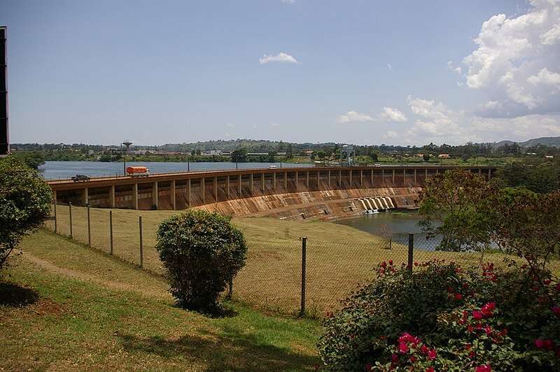
Owen Falls Dam, Uganda. Credit: Nao Iizuka from Tokyo, Japan/Wikimedia Commons, CC BY

Uganda's Owen Falls hydropower plant has a rich history that predates the country's independence in 1962. The plant is located across the White Nile and sits between the towns of Jinja and Njeru on the shores of Lake Victoria. It is about 85 kilometers east of Kampala.

Uganda was a protectorate of the British empire from 1894 to 1962. In 1947, English engineer Charles Redvers Westlake recommended the construction of a hydroelectric dam at Owen Falls that was supposed to be East Africa's largest power project.

The governor of the Protectorate of Uganda, Sir Andrew Cohen, wrote at the time that the Owen Falls dam would open new horizons of opportunity and prosperity for Uganda and all who lived there. Cohen went on to note: "Despite its technical complexity and the fact that we have had to draw upon skill and experience from many parts of the world, it belongs to Uganda and to Uganda's people. The power which the dam will provide and the industries it will make possible will bring solid benefit to everybody in the shape of increased wealth; above all, it will bring new opportunities to Africans."

At its completion in 1954, the dam immediately expanded Uganda's electricity supply capacity from 1MW to 150MW. But the expected boom in electricity consumption didn't happen. One textile mill and a copper smelter were the only industrial establishments to crop up.

The Uganda Electricity Board (UEB)—which was established on 15 January 1948—resorted to selling between one third and one half of the electricity generated to Kenya.

The institutional arrangements for constructing the dam left a damaging legacy that is still felt today. The British established governance arrangements for Nile waters that effectively granted Egypt veto power over all  on the Nile. This legal regime continues to cause conflict between Nile riparian states to this day.

Owen Falls' construction has to be seen as part of a racist colonial project, the sole objective of which was the exploitation of peoples and their resources to maximize British interests.

Empire's twisted logic

At the end of World War II there were protests throughout the British empire as demands for independence began picking up pace.

In Uganda, the country's new colonial governor, Sir John Hathorn Hall, was forced to take action. Some of the steps he took were informed by the need for the colonial government to show restless and poverty-stricken Ugandans that it was interested in promoting , industrialisation and development.

The dam was supposed to help Ugandans utilize their own natural resource—the water in Lake Victoria—to provide themselves with a significant level of energy independence.

But, in the twisted logic of the empire, achieving this goal was constrained by London trying to achieve interests elsewhere. In this case, British agricultural interests in Egypt.

In 1929, Egypt and Britain had signed the Anglo-Egyptian Treaty, which was designed to harness the waters of the Nile River and its tributaries to produce raw materials, notably cotton, for British industries.

The treaty, which created what are today known as historically acquired rights, was concluded without input from Uganda or other Nile riparian states.

These rights allocate virtually all Nile waters to Egypt and Sudan. They also grant Egypt veto power over all construction projects on the Nile River and its tributaries.

As Ugandans would later find out, the British had, without their permission, placed Egyptian officials in a position to veto development projects in Uganda and other upstream Nile Basin states.

Despite the fact that the Owen Falls dam was to be constructed on the White Nile in Uganda, Uganda was forced to obtain permission for its construction from Egypt.

Source of tension and conflict

The 1929 Anglo-Egyptian Treaty and the 1959 Nile Treaty—which was a bilateral agreement between Egypt and Sudan—continue to fuel conflict between the downstream and upstream states in the Nile Basin.

In fact, Ethiopia's refusal to abide by and be bounded by these colonial anachronisms has forced officials in Cairo to threaten to go to war to maintain Egypt's acquired rights.

In accordance with the spirit of the 1929 Anglo-Egyptian Treaty, colonial Uganda was forced to submit the documents for constructing the Owen Falls dam to Cairo for approval.

The construction of the dam would be the responsibility of the UEB, which was also to administer and maintain the project. However, the interests of Egypt were to be represented at the  by an Egyptian resident engineer, who would instruct the UEB on the discharges to be passed through the dam.

It is no wonder that when Ethiopia announced its intention in 2011 to construct a dam on the Blue Nile, Egypt sought similar concessions. Just as it had demanded of colonial Uganda, Egypt sought to maintain technical staff at the site of Ethiopia's dam to monitor its operations.

Racism on site

The racist foundations of colonialism were quite evident at the Owen Falls dam site. For example, after estimating that the job would require a  of 2,000, the UEB built labor quarters for Europeans and Asians, complete with a club, community center and swimming pool, at the Amberly Estate north of Jinja.

But it chose to house all African staff in quarters located across the bridge in Njeru.

These discriminatory economic and social policies would spill into the post-independence period and be exploited by dictator Idi Amin for his personal interests.

When she died on 8 September 2022, some Ugandans remembered Queen Elizabeth II as the young monarch who, in 1954, inaugurated the Owen Falls dam as a symbol of energy independence and ushered in a new era of industrialization and economic development in Uganda.

But others remember her as the person who, over 70 years, presided over a country that reminds them of brutal exploitation, including the theft of their resources

Ethiopia's controversial mega-dam

Provided by The Conversation 

This article is republished from The Conversation under a Creative Commons license. Read the original article.The Conversation

A new field of research: Crystal traces in fossil leaves

A new field of research: Crystal traces in fossil leaves
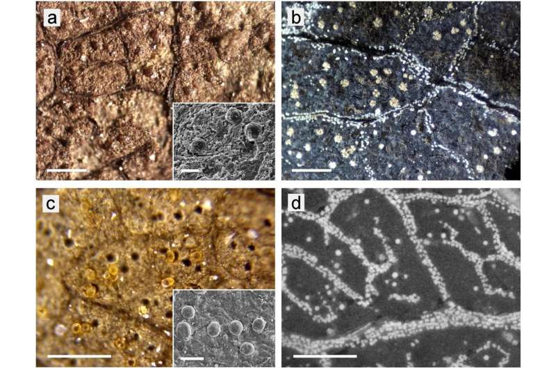
Globular structures in fossil leaves in comparison with CaOx druses of fresh leaves. 
LM images; surface illumination, 10 × objective. (a) Fossil sample Ro-90_1 
(Quercus neriifolia) with large brown globules; the inserted SEM image shows globules in 
detail. (b) druses of various size and small crystals in a burnt leaf of Quercus variabilis.
 (c) Fossil sample Ro-100_5 (Salix longa) with yellow transparent globules and many
 empty cavities, which remained when globules were pulled out during splitting the fossil. 
(d) Druses and crystals in a burnt leaf of Salix miyabeana. Scale bars: (ad) = 200 µm;
 insets (a,c) = 40 µm. Credit: Scientific Reports (2022). DOI: 10.1038/s41598-022-20144-4

In fossil leaves, puzzling structures are often visible under the microscope. Researchers at the University of Bonn have now been able to show for the first time that they originate from calcium oxalate crystals. On the one hand, their discovery facilitates the identification of the ancient plant remains. But it also provides answers as to how the ability to form such crystals arose and what function they presumably perform. The results have now been published in the journal Scientific Reports.

Fossil specimen Ro-59.9 is littered with microscopic cavities. Some of them look as if tiny raspberries had once slumbered inside them, each of them just two hundredths of a millimeter in size. The fossilized  comes from the Rott fossil site near Bonn and is more than 20 million years old. At the moment, it is not possible to say to which  it belongs.

Perhaps that will change soon. Because the position and shape of the cavities are like a kind of fingerprint: they can be used to identify fossil plant remains.

"Until now, it was not known how these cavities were formed," explains Mahdieh Malekhosseini from the Institute of Geosciences at the University of Bonn.

"For example, it was believed that they came from algae or pollen from other plants that somehow got onto the leaf during fossilization. But after analyzing hundreds of these structures, we can rule that out. Instead, we were able to show that calcium oxalate crystals are responsible for the depressions."

Microlenses for better photosynthesis?

Calcium oxalate is formed by very many living plants; it is considered one of the most common biominerals. What functions it fulfills has not yet been conclusively clarified. However, it is suspected that the crystals serve as calcium stores. In addition, because they are formed in the leaf but often penetrate the leaf surface as they grow, they probably repel pests.

"Many insects have an aversion to calcium oxalate—they don't like to walk on it," explains Prof. Dr. Jes Rust, who supervised the study. "Some plants also seem to use the crystals as microlenses to use sunlight more efficiently for photosynthesis."

The crystals are very sensitive to acid. They therefore dissolve during fossilization and can no longer be detected in the millions of years old finds. Often, however, imprints remain in the places where they have sat (in biology one speaks of "druses"). Sometimes  or other minerals also accumulate in these depressions, which then sit like tiny beads in the fossil leaf.

"We studied the microstructure of the pits and their distribution on  whose species affiliation we knew," Malekhosseini explains. "In addition, we looked at calcium oxalate crystals in the leaves of present-day plants. We found clear parallels in closely related species. For example, the crystal imprints in a fossil ginkgo leaf strongly resemble the calcium oxalate deposits of a present-day ginkgo in distribution and structure."

Important insights into evolution

It was already known from the fossils of bare-seeded plants such as firs or pines that they sometimes show imprints of calcium oxalate crystals. However, this was not known of angiosperms—which are most flowers and deciduous trees. "This is a completely new field of research," explains Jes Rust. "Among other things, we now want to investigate how the ability to form  crystals has developed over the course of evolution."

In doing so, the researchers want to focus on periods when  changed rapidly—such as temperature or the intensity of UV radiation. "If the distribution of the drusen also changes after such incisions, then we can draw conclusions about the biological function of the crystals," says Rust.

Q and A: Kidney stones and calcium

More information: Mahdieh Malekhosseini et al, Traces of calcium oxalate biomineralization in fossil leaves from late Oligocene maar deposits from Germany, Scientific Reports (2022). DOI: 10.1038/s41598-022-20144-4

Journal information: Scientific Reports 

Provided by University of Bonn 

Green hydrogen: Faster progress with modern X-ray sources

Green hydrogen: Faster progress with modern X-ray sources
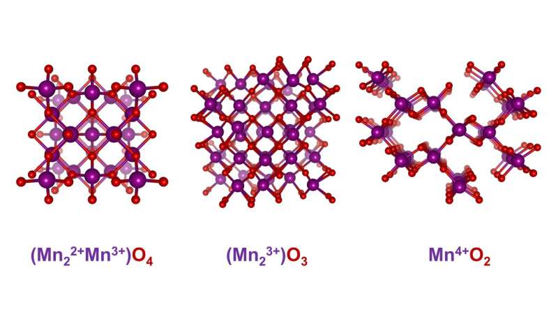
Manganese oxides come in many different structural variants. They are an exciting class of materials for electrocatalysts. Credit: M. Risch/HZB

Green hydrogen is an energy carrier with a future. It is obtained by electrolytically splitting water with energy from wind or sun and stores this energy in chemical form. To make the splitting of water molecules easier (and to reduce the energy input), the electrodes are coated with catalytically active materials.

Dr. Marcel Risch and his Young Investigator Group "Oxygen Evolution Mechanism Engineering" are investigating oxygen evolution in the electrocatalysis of water. Oxygen evolution in particular must run more efficiently for economical hydrogen production.

Exciting class of materials

An exciting class of materials for electrocatalysts are , which occur in many different structural variants. "A decisive criterion for suitability as an electrocatalyst is the  number of the material and how it changes in the course of the reaction," explains Risch.

In the case of manganese oxides, there is also a great diversity in possible oxidation states. X-ray  spectroscopy (XAS) provides information about the : X-ray quanta with suitable energy excite electrons on the innermost shells, which absorb these quanta. Depending on the oxidation number, this absorption can be observed at different excitation energies. Risch's team has constructed an electrolysis cell that enables XAS measurements during electrolysis.

X-ray absorption spectroscopy

"With X-ray absorption spectroscopy, we can not only determine the oxidation numbers, but also observe corrosion processes or phase changes in the material," says Risch.

Combined with electrochemical measurements, the measurement data thus provide a much better understanding of the material during electrocatalysis. However, the required high intensity of the X-rays is only available at modern synchrotron light sources. In Berlin, HZB operates BESSY II for this purpose. There are about 50 such light sources for research worldwide.

Time scales from short to long

Risch still sees great potential for the application of X-ray absorption spectroscopy, especially with regard to the time scales of observation. This is because typical measurement times are a few minutes per measurement. Electrocatalytic reactions, however, take place on shorter time scales.

"If we could watch electrocatalysis as it happens, we could better understand important details," says Risch. With this knowledge, cheap and environmentally friendly catalysts could be developed more quickly. On the other hand, many "aging" processes take place within weeks or months. "We could, for example, examine the same sample again and again at  to understand these processes," Risch advises. This would also make it possible to develop electrocatalysts with long term stability.

The research was published in Angewandte Chemie.Green hydrogen: Why do certain catalysts improve in operation?

More information: Marcel Risch et al, What X‐Ray Absorption Spectroscopy Can Tell Us About the Active State of Earth‐Abundant Electrocatalysts for the Oxygen Evolution Reaction, Angewandte Chemie (2022). DOI: 10.1002/ange.202211949

Journal information: Angewandte Chemie 

Provided by Helmholtz Association of German Research Centres 

Scientists peel back ancient layers of banana DNA to reveal 'mystery ancestors'

Scientists peel back ancient layers of banana DNA to reveal 'mystery ancestors'
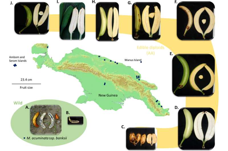
Map of New Guinea Island and examples of fruits of M. acuminata ssp. banksii.
 Credit: Frontiers in Plant Science (2022). DOI: 10.3389/fpls.2022.969220

Bananas are thought to have been first domesticated by people 7,000 years ago on the island of New Guinea. But the domestication history of bananas is complicated, while their classification is hotly debated, as boundaries between species and subspecies are often unclear.

Now, a study in Frontiers in Plant Science shows that this history is even more complex than previously thought. The results confirm that the genome of today's domesticated varieties contains traces of three extra, as yet unknown, .

"Here we show that most of today's diploid cultivated bananas that descend from the wild banana M. acuminata are hybrids between different subspecies. At least three extra wild 'mystery ancestors' must have contributed to this mixed genome thousands of years ago, but haven't been identified yet," said Dr. Julie Sardos, a scientist at The Alliance of Bioversity International and CIAT in Montpellier, France, and the study's first author.

Complex domestication history

Domesticated bananas (except for the Fei bananas in the Pacific) are thought to be descended from a cluster of four ancestors ̶ either subspecies of the wild banana Musa acuminata, or distinct but closely M. acuminata seems to have evolved in the northern borderlands between India and Myanmar, and to have existed across Australasia approximately 10m years before it was first domesticated. A further complication is that domesticated varieties can have two ('diploid'), three ('triploid'), or four ('tetraploid') copies of every chromosome, and that many are also descended from the wild species M. balbisiana.

Recent smaller-scale studies suggested that even this already complex scenario might not be the whole story, and that further ancestors related to M. acuminata could have been involved in the domestication. The new results not only confirm that this is indeed the case, they also show for the first time that that these gene pools are common in domesticated banana genomes.

Banana collecting missions

The authors sequenced the DNA in 226 extracts leaf extracts from the world's largest collection of banana samples at The Alliance of Bioversity International and CIAT's 'Musa Germplasm Transit Center' in Belgium. Among these samples, 68 belonged to nine wild subspecies of M. acuminata, 154 to diploid domesticated varieties descended from M. acuminata, and four more distantly related wild species and hybrids as comparisons. Many had previously been gathered in dedicated 'banana collecting missions' to Indonesia, the island of New Guinea, and the autonomous region of Bougainville.

The researchers first measured the levels of relatedness between cultivars and wild bananas and made ´family trees´ based on the diversity at 39,031 Single Nucleotide Polymorphisms (SNPs). They used a subset of these—evenly spread across the genome, with each pair demarcating a block of approximately 100,000 'DNA letters'—to statistically analyze the ancestry of each block. For the first time they detected traces of three further ancestors in the genome of all domesticated samples, for which no matches are yet known from the wild.

Mystery ancestors might survive somewhere

The mystery ancestors might be long since extinct. "But our personal conviction is that they are still living somewhere in the wild, either poorly described by science or not described at all, in which case they are probably threatened," said Sardos.

Sardos et al. have a good idea where to look for them: "Our genetic comparisons show that the first of these mystery ancestors must have come from the region between the Gulf of Thailand and west of the South China Sea. The second, from the region between north Borneo and the Philippines. The third, from the island of New Guinea."

Could help breed better bananas

Which useful traits these mystery ancestors might have contributed to domesticated bananas is not yet known. For example, the crucial trait of parthenocarpy, fruit setting without the need for pollination, is thought to have been inherited from M. acuminata, while cooking bananas owe a large chunk of their DNA to the subspecies (or perhaps separate species) M. acuminata banksii.

Second corresponding author Dr. Mathieu Rouard, likewise at Bioversity International, said: "Identifying the ancestors of cultivated bananas is important, as it will help us understand the processes and the paths that shaped the banana diversity observed today, a crucial step to breed bananas of the future."

"Breeders need to understand the genetic make-up of today's domesticated diploid bananas for their crosses between cultivars, and this study is a major first step toward the characterization in great detail of many of these cultivars."

Sardos said: "Based on these results, we will work with partners to explore and genotype wild banana diversity in the three  that our study pinpointed, with the hope to identify these unidentified contributors to cultivated bananas. It will also be important to investigate the different advantages and traits that each of these contributors provided to cultivated ."

On the hunt for wild bananas in Papua New Guinea

More information: Julie Sardos et al, Hybridization, missing wild ancestors and the domestication of cultivated diploid bananas, Frontiers in Plant Science (2022). DOI: 10.3389/fpls.2022.969220

Journal information: Frontiers in Plant Science 

Provided by Frontiers 

Slight shifts in magnetic field preceded California earthquakes

Slight shifts in magnetic field preceded California earthquakes
The magnitude 6 South Napa earthquake in California in August 2014 caused the ground to rupture in places, including in this vineyard. Credit: U.S. Geological Survey, Public Domain

Researchers studying intermediate to large earthquakes in California have discovered detectable changes in the local magnetic field that occur 2–3 days before an earthquake. In a study now published in Journal of Geophysical Research: Solid Earth, William Heavlin and his team found that the signal of the magnetic field change is faint but statistically significant, and the seismologists hope their technique can be refined to eventually help forecast earthquakes.

"It's a modest signal," said Dan Schneider, director of QuakeFinder, an earthquake research department in Stellar Solutions, a systems engineering services company. "We are not claiming that this signal exists before every earthquake," said Schneider, a coauthor of the study, "but it is very intriguing."

The idea that the magnetic field may shift before earthquakes has been around for a while, but it's always been controversial. The U.S. Geological Survey states that "despite decades of work, there is no convincing evidence of electromagnetic precursors to earthquakes."

In collaboration with the Google Accelerated Science team, the scientists tapped into magnetic field data from an array of magnetometers at 125 sensor stations along major faults in California. They gathered data from 2005 to 2019, during which time 19 earthquakes of magnitude 4.5 or greater occurred on the faults.

Their multi-station analysis accounted for other kinds of processes that might affect the magnetometers but have nothing to do with earthquakes, such as rush hour traffic. Differentiating this kind of noise from potential -related signals is the tallest barrier to interpret these data, Schneider said. After training their algorithms on half the data set, the researchers identified a signal indicating changes in the magnetic field between 72 and 24 hours before the earthquakes.

Schneider said that in the future, he'd like to further hone the models to eliminate more  from the magnetometers. In this study, for example, accounting for the average influence of  substantially improved the results. In continuing work, the team will use remote station data to further eliminate noise due to solar activity.

The work suggests "there may be regular detectable changes in the  that with further study and isolation, could actually support the construction of a forecasting system in the future," Schneider said.Can magnitude 4 earthquake rates be used to forecast large earthquake events?

More information: William D. Heavlin et al, Case‐Control Study on a Decade of Ground‐Based Magnetometers in California Reveals Modest Signal 24–72 hr Prior to Earthquakes, Journal of Geophysical Research: Solid Earth (2022). DOI: 10.1029/2022JB024109

Journal information: Journal of Geophysical Research: Solid Earth 

Provided by Eos

This story is republished courtesy of Eos, hosted by the American Geophysical Union. Read the original story here.

Reign of Papua New Guinea's megafauna lasted long after humans arrived

Reign of PNG's megafauna lasted long after humans arrived
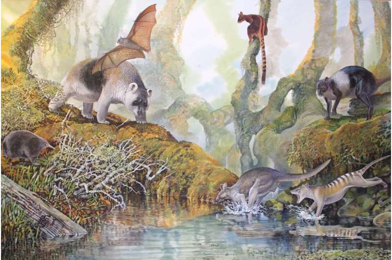
Illustration of PNG megafauna Hulitherium, Thylacine, Protemnodon, Tree Kangaroo, 
Bulmer's Flying Fox and Bruijn's Long-beaked Echidna (left to right) species: Hulitherium 
thomasetti, Thlacinus sp. cf. T. cynocephalus, Protemnodon nombe, Protemnodon 
tumbuna, Dendrolagus noibano, Aproteles bumerae (extant), Zaglossus bruijni (extant) in 
New Guinea, Upper Montane forest. Credit: Peter Schouten (End of the Megafauna)

A giant kangaroo that once roamed on four legs through remote forests in the Papua New Guinea Highlands may have survived as recently as 20,000 years ago—long after large-bodied megafauna on mainland Australia went extinct, new research indicates.

Flinders University paleontologists, working with Australian National University archaeologists and geoscientists, have used new techniques to re-examine megafauna bones from the rich Nombe Rock Shelter fossil site in Chimbu Province in a bid to better understand the intriguing natural history of PNG.

The fresh analysis produced revised ages of the bones and suggests that several large mammal species, including the extinct thylacine and a panda-like marsupial (called Hulitherium tomasettii) still lived in the PNG Highlands when people first arrived, possibly around 60,000 years ago.

Remarkably, two large extinct kangaroo species, including one that bounded on four legs rather than hopping on two legs, may have persisted in the region for another 40,000 years.

"If these megafaunal species did indeed survive in the PNG Highlands for much longer than their Australian equivalents, then it may have been because people only visited the Nombe area infrequently and in low numbers until after 20,000 years ago," says ANU Professor of Archaeological Science Tim Denham, co-lead author in the new study published in the journal Archaeology in Oceania.

"Nombe rock shelter is the only site in New Guinea known to have been occupied by people for tens of thousands of years and preserves remains of extinct megafaunal species, most of them unique to New Guinea.

"New Guinea is a forested, mountainous, northern part of the formerly more extensive Australian continent called 'Sahul' but our knowledge of its faunal and human history is poor compared with that of mainland Australia," says Professor Denham who initially undertook fieldwork in the PNG Highlands in 1990.

Reign of PNG's megafauna lasted long after humans arrived
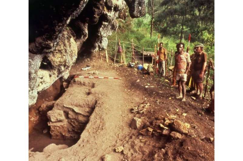
Excavations at the Nombe rock shelter taken in 1979 during early fieldwork led by the Australian National University. Credit: Barry Shaw (ANU) / Archaeology in Oceania journal.

Research co-author Professor Gavin Prideaux, from the Flinders University Palaeontology Laboratory, says the latest Nombe study is consistent with similar evidence from Kangaroo Island, previously produced by Flinders paleontologists and published in the Journal of Quaternary Science in 2015, that also suggests megafaunal kangaroos may have persisted to around 20,000 years ago in some of the less accessible areas of the continent.

He says many general assumptions about megafaunal extinction timelines have been "more harmful than helpful".

"Although it is often assumed that all of the megafaunal species in Australia and New Guinea became extinct coast to coast by 40,000 years ago, this generalization is not based on very much actual evidence," says Professor Prideaux. "It is probably more harmful than helpful in resolving exactly what happened to the dozens of large mammals, birds and reptiles that were living on the continent when people first arrived."

The Nombe rock shelter, located in the vicinity of the Nongefaro, Pila and Nola communities in PNG, would have been infrequently visited by nomadic groups of Highlands peoples in prehistoric times.

The hidden rock shelter was first excavated by archaeologists in the 1960s, but the most intensive phase of fieldwork was conducted 1971 and 1980 by ANU archaeologist Dr. Mary-Jane Mountain, who is also an author on the latest paper. Her initial research yielded the first detailed description and interpretation of the Nombe site and played a pivotal role in shaping our understanding of the  of the PNG Highlands.

"Mary-Jane (Mountain) initially hypothesized that megafauna at the site may have survived for tens of millennia after human colonization, but this has only been confirmed with the advent of new techniques in archaeology, dating and paleontological science," Professor Denham says.

Professor Prideaux says these new applications of modern analytical techniques, or new excavations at the Nombe site, would further confirm timelines of late surviving megafauna and duration of occupation by people in PNG.

The latest research was published in Archaeology in Oceania.Researchers describe new kangaroo fossil from Papua New Guinea

More information: Gavin J. Prideaux et al, Re‐evaluating the evidence for late‐surviving megafauna at Nombe rockshelter in the New Guinea highlands, Archaeology in Oceania (2022). DOI: 10.1002/arco.5274

Matthew C. Mcdowell et al, Re-evaluating the Late Quaternary fossil mammal assemblage of Seton Rockshelter, Kangaroo Island, South Australia, including the evidence for late-surviving megafauna, Journal of Quaternary Science (2015). DOI: 10.1002/jqs.2789

Journal information: Journal of Quaternary Science 

Provided by Flinders University