Monday, July 15, 2024


How a Gulf of Alaska Test Range Helped Israel Defend Itself From Iran

Alaska’s little-known spaceport revolutionized military conflict

Pacific Spaceport Complex, Kodiak, Alaska. Photo: M. Bennett, March 2024

PUBLISHED JUL 14, 2024 2:35 PM BY MIA BENNETT


At the Pacific Spaceport Complex in Kodiak, Alaska, in 2019, the Israelis successfully tested an anti-ballistic missile system that intercepts weapons in space. Now, in the Israel-Hamas War, it’s finally being used in battle, pushing military conflict above the atmosphere.

Kodiak Island is better known for its salmon-guzzling grizzly-bears than its rockets. But the forested Alaskan isle, separated from the mainland by the Shelikof Strait, has had a small commercial spaceport since 1998. Kodiak’s Pacific Spaceport Complex is intended for launching small satellites into polar orbit and got its start as the country’s first commercial spaceport. More famous facilities, like Cape Canaveral Space Force Station and Vandenberg Space Force Base, are government-operated spaceports. Yet the majority of the 31 launches that have taken place at Pacific Spaceport Complex since its opening have, in fact, been for the military or government, including one foreign one: Israel. The shift towards supporting launches by the men in black has frustrated many of Kodiak’s residents, as I discovered when I visited the island last month.

Why is there a spaceport on Kodiak Island?

Kodiak might seem an unlikely spot for launching satellites into orbit. Spaceports are generally built closer to the equator to take advantage of the additional thrust provided by the Earth, which spins faster in the middle. Since the entire planet rotates once every 24 hours, objects on the equator are advancing 1670 km per hour. Those halfway to the North or South Pole are moving a mere 1170 km per hour, or 30 percent slower. Consequently, more rocket fuel is needed to launch from poleward locations to achieve the whopping speed of 40,270 kilometers per hour necessary to achieve escape velocity.

This advantage of equatorial launch sites, however, is negated when trying to launch into polar orbit. Polar orbits are used by satellites performing Earth observation or reconnaissance missions that image the entire planet. Each time a polar-orbiting satellite circles the Earth, it passes over the North or South Pole, providing full planetary coverage. Polar orbits are becoming increasingly popular as both governments and commercial firms seek to provide up-to-date satellite imagery of the entire planet.

Some northern countries and states like Alaska are hoping that satellite operators might turn to spaceports located in the world’s northern latitudes to reach polar orbits. Among them are not only the Pacific Spaceport Complex, but other other up-and-coming competitor spaceports like Andøya in northern Norway, Esrange in northern Sweden, and SaxaVord Spaceport in Shetland, in the northernmost bit of the United Kingdom.

Despite the seeming advantages of polar spaceports, many of the commercial actors that the Pacific Spaceport Complex has sought to attract have swallowed the extra fuel costs of launching from the south and transported their rockets and satellites to spaceports like southern California’s Vandenberg Space Force Base. These are much closer to major infrastructure and engineering facilities in places like Los Angeles and don’t require arranging complicated, expensive logistics to transport material to the Arctic or sub-Arctic by plane or barge. The cold waters around Kodiak Island make for some of the world’s richest fish and crab stocks, as made famous in the television show Deadliest Catch, but are notoriously harsh for boats. The turbulent weather around the Emerald Isle also means that rain, fog, and wind all challenge the reliability of the airport for satellite operators, which often have short windows in which to prepare and undertake missions.

The difficulties that the Pacific Spaceport Complex has encountered in attracting market share means that only nine of their 31 launches have been orbital. The rest have been suborbital launches, or those that fly into space but do not reach escape velocity and return to the atmosphere before fully orbiting Earth. While these might sound less than spectacular, military conflict is rapidly evolving in suborbital space, with one key innovator at the helm: Israel.

Anti-intercontinental ballistic missile testing on Kodiak

In July 2019, three suborbital launches went soaring into the blackness of space over the inky waters of the Gulf of Alaska surrounding Kodiak. These launches had one purpose: to test the Israel Defence Ministry’s Arrow 3 Interceptor Missile System. The state-of-the-art technology built by Israel Atmospheric Industries and troubled U.S. aerospace company Boeing employs “exoatmospheric hypersonic anti-ballistic missiles,” which can intercept and destroy incoming long-rang missiles above the atmosphere. The system provides a top layer of defense that complements Israel’s more famous “Iron Dome”, which shields the country from rockets and bombs fired closer to the ground.

Between 2008-2021, the U.S. government contributed $1.27 billion to Israel’s Arrow 3 program. Its support for Israel’s Arrow system has been consistent, with development first beginning in 1986. In 2004, the Naval Air Station Point Mugu Missile Test Center in southern California hosted tests of Arrow 2, which uses an explosive to destroy incoming medium- to long-range missiles. In contrast, Arrow 3 destroys incoming long-range missiles through interception alone in the exoatmosphere, or the region just above the Earth’s atmosphere. They must be designed to operate in a vacuum, requiring complicated engineering to deal with low pressure [1].

In June 2017, during a Congressional hearing, U.S. Vice Admiral James Syring explained the role that Kodiak would play in testing Arrow 3:

Admiral Syring: Yes, sir. We are close partners with Israel on development of their systems, system engineering in particular, and testing support also. And I have been intimately involved with them on David's Sling and Arrow, the more recent version of Arrow 3. And, frankly, that interceptor is now up into the exoatmosphere, and it has significant range constraints within the Mediterranean. And one of the better places to test is in Alaska, from Kodiak, and we plan to do that next year.

Mr. Coffman: Okay. So the Arrow 3 is designed to defeat the over-the-horizon capability of the Iranians. Am I correct in that?

Admiral Syring: Sir, it is designed to defeat the exoatmospheric ballistic missile threat from Iran.

In other words, given the crowded airspace around the Mediterranean, Israel was unable to test Arrow 3 to its full capacities. Moshe Patel, director of the Israel Missile Defense Organization, said in March 2019 during a panel discussion in Washington, D.C.: “Arrow 3 is too big for the state of Israel…It is supposed to be good against nuclear threats that are coming from Iran. (But) we have limitations in our arena to conduct flight tests because of safety.”

That’s where remote Kodiak, Alaska – an island home to 13,500 people and several Alaska Native villages – came in. In 2016, Alaska Aerospace Corporation and the U.S. Missile Defense Agency announced a five to six year, $80.4 million contract, which led to a follow-on award in 2022 for $111 million. The Missile Defense Agency sponsored Israel’s interceptor testing at the Pacific Spaceport Complex, along with the construction of new accommodation for 210 people. The spaceport is about an hour’s drive from the main town of Kodiak on a windy road, which makes commuting difficult. There is little housing in the area save for some cabins in the nearby community of Pasagshak and a fairly large yet oddly underutilized lodge nicknamed the “space hotel”.

Craig Campbell, the former CEO of Alaska Aerospace Corporation, a State of Alaska public corporation that operates the spaceport, offered some further details about the missile system being tested and what would need to be built to support it. “This is much more of a mobile system, so we’re going to put in a life support area where soldiers can actually live and operate as if they were deployed into real life conditions to utilize the system.” Those real life conditions would ultimately be the deserts of Israel rather than Kodiak’s spruce-covered capelands.

A synagogue and Kosher food on Kodiak

In 2016, Alaska Aerospace Corporation issued a request for proposals (RFP) to build the “life support area” for the Israelis. Controversy swirled over the RFP, which required the housing to be destroyed after the testing ended. While there was a lower bid from Bernie Karl, who operates the lodge “space hotel” along with the popular Chena Hot Springs outside Fairbanks, Alaska, his proposal said the housing would be “demobilized” rather than destroyed. Alaska Aerospace Corporation went with the other bid. Although it was $3.5 million more, it met the Missile Defense Agency’s demand that the housing be removed. (There were also rumors of nepotism around the winning bid, which this short Anchorage Daily News story and podcast from 2018 explore).

To accommodate 210 people, the developers plowed a new area and brought in mobile housing units stacked two stories high. The “life support area” also entailed building a makeshift synagogue, bringing in a Kosher cook, and putting up barbed wire fencing since, in the words of one resident recalling the development, the Israelis were “super-paranoid.” After the accommodations were initially completed, they had to be moved and re-erected as regulators said that they were too close to the launch pad.

After all the hullaballoo over constructing the accommodations, a year passed. On a clear summer day in 2019, the missile testing went off without a hitch. The flags of the U.S., Israeli, and two involved missile defense agencies fluttered in the glow of the blast zone.

Immediately following the suborbital launches, U.S. Senator Dan Sullivan (R-Alaska) stated, “The test this weekend shows the strength of U.S.-Israeli cooperation on missile defense. It should send a strong message to our common adversary, Iran, about our ability to deter any aggressive act against our allies in the region.” He continued, “I want to commend all those who invested the thousands of hours of preparation that went into producing this successful test. In particular, I also want to thank the people of Kodiak who have been host to American and Israeli officials working to conduct this historic test.”

After the Israelis successfully completed their testing, all of the accommodations were ripped out of the ground. (Concerns expressed in a letter to the editor of the Kodiak Daily Mirror expressing worry that the facility could become a permanent Israeli base were unfounded.) When I visited the spaceport, all that remained of their former facility was a bunch of wires sticking out of the ground. You would never really know that the Israel Defence Ministry, with the backing of the U.S. Missile Defense Agency, had been here, on Alaskan public lands, testing pioneering anti-ballistic missile technology. One Israeli expert even claimed that Arrow 3 could be adapted to shoot down satellites.

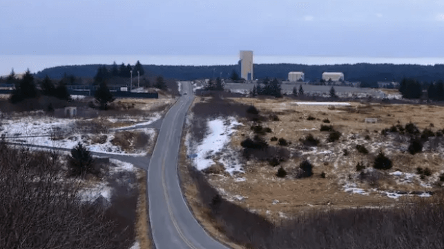
Little remains of the “life support area” built to accommodate 210 people, many of them members of the Israel Defense Forces, at the Pacific Spaceport Complex in Kodiak, Alaska. Photo: M. Bennett, March 2022.

\Israel-Hamas War: The first-ever instance of space warfare

While the Israelis left Kodiak in 2019, they continued to make progress on the Arrow 2 and 3 systems back on the shores of the Mediterranean. Four years later, on October 31, 2023 – weeks after the outbreak of war between Israel and Hamas – the country used the Arrow 2 system tested in California to shoot down a ballistic missile fired by the Iran-backed Houthis at Eilat, Israeli’s southernmost city, from some 1,600 kilometers away. According to The Telegraph, Arrow 2 intercepted the Houthi missile high over the Red Sea above the Kármán line, which is generally identified as where space starts, 100 kilometers above sea level. The Israel Defense Forces released a video of the launch, which culminated in the first-ever instance of space warfare with the destruction of the Houthi missile.

A little over a week later on November 9, the IDF announced Arrow 3’s first successful interception. Israel has continued to use the Kodiak-tested Arrow 3 throughout the war. A video posted to Reddit two weeks ago by the user captures the exoatmospheric interception. In a separate thread, another user who observed the blast – clearly a military rocket enthusiast – wrote, “The explosion was really big, widely visible and colorful considering how high it was. Video doesn’t do it justice. Probably 5-10 times the apparent size of the full moon. One of the coolest things I’ve ever seen.”

For all the hopes since the Space Age that the heavens be kept for “peaceful purposes,” as stated in the 1967 Outer Space Treaty, there is no doubt now of their militarization.

The Arctic as global military frontier and vanguard

Since the Cold War, the Arctic has proven central to U.S. and Russian (previously Soviet) missile defense systems, with each superpower guarding against projectiles that might be lobbed across the frozen North Pole. Now, thanks to Kodiak’s Pacific Spaceport Complex, the region has proven key for testing missile defense systems based in the arid Middle East, guarding against weapons that pierce the exosphere.

In August 2023, Israel sold Arrow 3 to Germany for $3.5 billion after receiving U.S. approval, representing the largest-ever arms deal for Jerusalem. In the wake of the Russia-Ukraine War, Germany is seeking to boost its defenses against a revanchist neighbor to the east. Berlin may have a bit more breathing room thanks to the Kodiak-tested system.

The benefits of military testing in the Arctic snake out to American allies far and wide, who conduct their operations on the ground and above the atmosphere. The Arctic military frontier has not just expanded to the rest of the globe, but to space. The Arctic, meanwhile, must deal with the legacy of militarization that leaves behind barren land, debris, and often toxic waste – all while making sure to rip anything useful, like accommodation, out of the ground. The testimony delivered by Sarah Lukin, member of the Afognak Native Corporation’s board of directors (and now president of Cook Inlet Region, Inc.), to Congress during a hearing on cleaning up the country’s Cold War legacy sites captured how the military haunts the north, long after it has left:

“World War II, Japan’s invasion of the Aleutians, and the Cold War had profound impacts in Alaska. If Alaska’s expansive forests and tundra could talk, what stories would they tell? We would hear of 55-gallon drums full of toxic materials dumped in lakes, of unexploded ordnances on the tundra, a stream with lead batteries in it, Cold War legacies often hidden from view, but slowly decaying, leaching into the ground and water.”

Mia Bennett is an assistant professor in the University of Washington's Department of Geography. She researches the politics of infrastructure development in the Arctic by combining fieldwork and critical remote sensing, and she is a frequent contributor to The Maritime Executive. 

This article appears courtesy of Cryopolitics and may be found in its original form here

Further reading

[1] Sullins, G. (2001). Exo-atmospheric intercepts: Bringing new challenges to Standard Missile. Johns Hopkins APL Technical Digest, 22(3): 260-274.

The opinions expressed herein are the author's and not necessarily those of The Maritime Executive.


Philippine Coast Guard Conducts MOB Search for Missing Boxship Captain

search operation
SAR operation is checking the waters and coast of the local islands for the missing captain (PCG)

PUBLISHED JUL 12, 2024 10:48 AM BY THE MARITIME EXECUTIVE


The Philippine Coast Guard has been conducting a search over the past few days for the missing captain of a containership. The vessel was transiting the central Philippines when according to the Coast Guard the crew “noticed their captain was missing.”

Based on the CCTV footage on board the containership Cape Bonavista (24,754 dwt), the captain was last seen at around 10:46 p.m. local time on July 6. The vessel registered in the Marshall Islands departed the southern Philippine port of Davao City and was sailing to China. The vessel built in 2023 has a capacity of 1930 TEU. It is managed from Cyprus by Columbia Shipmanagement and operated under charter to CMA CGM on a route shuttling between China, Hong Kong, and the Philippines.

The Coast Guard dispatched its vessel BRP Malapascua starting on July 7 to conduct a search and rescue operation for the missing captain in the vicinity waters of Lubang Island, south of Manila. The vessel has been using its thermal scanner camera which is part of its Remote-Controlled Weapon System and established a parallel search pattern in the vicinity. It is also coordinating with the Philippine Navy.


The master is only described as a Ukrainian citizen. The Coast Guard reports that it had no results. After replenishing provisions and refueling the patrol boat resumed the search checking the waters and area around Lubang Island.

The containership after remaining in the local area proceeded to the Chinese port of Shekou where it arrived this morning local time.


Sentiment & Science: Public Perception of Alternative Fuels 

LNG bunkering
File image courtesy CMA CGM

PUBLISHED JUL 14, 2024 10:20 PM BY PETER KELLER


The idea that 2050 is a remote date has to be one of the biggest obstacles facing the maritime industry.

There is no denying we are already on the countdown. We currently only have some 305 months until we are committed to achieving net zero. This is a daunting realization and despite our common goal and common challenges, the industry is struggling to find common ground.

Theoretical, unproven solutions have shifted focus away from practical alternatives that the industry needs to seriously consider for long-term adaptation. Today, a lack of understanding of alternative fuels appears to overshadow action. Technology is often difficult to grasp, and the magnitude of the financial reality maritime faces is vast.

The gap between what we hear and what we see is vast.

The Maritime Alternative Fuels Barometer quantifies this gap. The Barometer, commissioned by SEA-LNG and conducted by maritime tech research consultancy, Thetius compares current perceptions of future fuels against reality.

With insights from key industry stakeholders, the report looks at availability, supply, technological readiness and impact on emissions. The objective is to help bridge the gap. To provide a comprehensive outlook and to aid the industry in making informed decisions.

Vast potential, fraught with complexities

The 2050 deadline may be firmly on the horizon, but the current roadmap to net zero is marked with interim targets from the IMO. A ~20% cut in GHG emissions by 2030. A ~70% cut in GHG emissions by 2040. This does not account for other regional regulations, or competitive, commercial objectives.

Asking where we currently stand is a tough question. On the one hand, the industry has a wealth of practical solutions at its fingertips and innovation continues.

But we must stop waiting.

As the Barometer rightly points out there are no silver bullets. And looking ahead to 2050, all potential solutions require the industry to overcome daunting challenges.

The right solutions to create the right solutions

Given the time frames, if a fuel is going to be a future fuel we need an obvious pathway forward.

This is a repeated finding from the Barometer. Most obstacles to achieving net zero are commercial viability, availability and technical capabilities.

Investment is among the most critical factors. Not only in the fuel production itself, but across supply chain infrastructure. Availability requires coordination across the whole supply chain with all its complexities and costs.

Where alternative fuels are concerned, the Thetius report indicates that LNG, ammonia and methanol are perceived favorably for 2030 and 2050 goals. Stakeholders acknowledged this was a complex, nuanced situation that is likely headed to a multi-fuel destination.

Gaining clarity: perceptions vs. reality

To properly understand viability, the industry needs to understand the reality of well-to-wake emissions.

Take methanol. According to findings in the Barometer, methanol has a strong backing in the industry as a future fuel. But it’s unclear whether this takes into consideration the different types of methanol that are produced.

If one uses renewable energy sources to produce “green” methanol, CO2 emissions could be cut by up to 95% compared to conventional fuels. But when produced with fossil fuel feedstocks (“gray” methanol) it could increase net GHG emissions to more than current conventional fuels.

To benefit from green methanol, we need to significantly scale production capabilities which means significant growth in renewables. This is not an insurmountable issue, but the future investment profile is huge. And it will likely be the mid-2030s before sufficient capacity is available for green methanol and other synthetic fuel production.

The Barometer found that public sentiment for ammonia as a future fuel is also strong, but infrastructure is a major focus. The fuel is highly toxic, and there are no current bunkering regulations to mitigate risk. Additional training and safety measures are a must-have if we are to protect seafarers, longshoremen and others in proximity to maritime facilities.

As for LNG, demand and sentiment were found to be extremely strong. In its current form, the fuel offers an immediate reduction in GHG emissions of up to 23%. Some LNG engine technologies suffer from the issue of methane slip, however, technologies to address this are rapidly evolving. The consensus is that slip will be a non-issue after 2030.

LNG is also the only fossil-derived fuel which cuts GHG emissions compared with traditional fuel oils. Importantly it also dramatically reduces SOx, NOx and Particulate Matter. These are all pollutants the industry has worked for decades to reduce.

The LNG pathway = immediate and long-term impact

With LNG, bio-LNG and e-LNG, we have a low risk, incremental pathway to a net zero by 2050. Owners and operators can utilize existing funded LNG bunkering infrastructure, and proven, safe shipboard technologies.

Over 1,000 vessels have chosen LNG (excluding LNG carriers) and LNG bunkers are now available in 185 ports, with an additional 50 being made available by 2025.

With bio-LNG, adoption can result in GHG reductions of typically 80% or more, depending upon the source of the biomass. It is already in use and compatible with existing infrastructure. Plus, bio-LNG bunkers are available in ~70 ports in Asia, Europe & North America.

Synthetic (or e-LNG) marks the ultimate phase in the pathway. Renewable hydrogen is needed to produce electro fuels, like e-LNG. Given the need to first produce renewable hydrogen, these fuels are likely to become available in sustainable quantities from the mid-2030s onwards. These hydrogen-based fuels are compatible with current LNG-fueled vessels and supply infrastructure. No need for newbuilds or vast investment.

Conclusion

As with all major change, collaboration is imperative. Shipowners and operators must work alongside investors, financiers and regulators to continue to establish reasonable, realistic and practical goals. Information sharing must become the norm, and be predicated upon real science and facts.

As the Barometer clearly notes there is not silver bullet to achieving net zero by 2050. The basket of fuels needed will be determined by technological developments, commercial viability and fuel availability.   

The Maritime Alternative Fuels Barometer demonstrates why we need to focus on real data and scientific facts, not theoretical and selective analysis. It will take financial commitment and science - supported by practical and realistic analyses - to reach informed decisions that generate action. Today and tomorrow.

[1033 words]

The opinions expressed herein are the author's and not necessarily those of The Maritime Executive.


ATSB: Pilot Error, Lack of Procedure Caused Bulker's Grounding

World Diana grounding
ATSB / Port of Bunbury

PUBLISHED JUL 14, 2024 5:27 PM BY THE MARITIME EXECUTIVE


Ineffective pilotage and port deficiencies caused the grounding of a bulk carrier last year, the Australian Transport Safety Bureau (ATSB) has determined.

In its final report on the grounding of the World Diana at the Port of Bunbury in April 2023, ATSB contends that ineffective bridge resource management was largely to blame for the incident. The port authority also came in for criticism: at the time, it had not developed adequate procedures for arrival and departure plans for larger ships, ATSB said.

On the morning of April 22, 2023, World Diana was scheduled to depart the Port of Bunbury with the assistance of a harbor pilot. The ship was berthed starboard side to at the number three berth, and needed to be maneuvered into the inner harbor turning basin and then turned to port towards the harbor entrance. It was nearly fully laden with a cargo of grain, destined for the Port of Kosichang in Thailand via the Singapore Strait.

The 81,200 dwt, 229-meter ship had a crew of 19. The pilot had completed about 4,000 pilotage movements at the port of Bunbury, including about 35 vessels of over 200 meters.

Beginning at 0542 local time, the pilot conducted a master-pilot exchange on the bridge. The departure plan called for two tugs to help the ship turn around and sail out of the harbor. At 0632, when all the mooring lines had been cast off, the pilot instructed both tug masters to ‘lift off’ using quarter power and, shortly after, asked them to increase to half power. Four minutes later the ship had developed slight headway with its main engine running dead slow ahead.

As the 2020-build Panamax bulker turned, its headway increased. By 0641, the ship’s bow was closing on the shallow water on the eastern side of the harbor. Two minutes later the bulker’s bow grounded on the bank and its speed rapidly reduced to zero. The pilot then maneuvered the ship astern using its propulsion and the tugs. Once the ship was established in the center of the turning basin, the turn was completed.

“This turn was started earlier than planned, reducing the amount of room available. The ship’s speed was then allowed to increase until there was no room to safely turn, and the bow of the ship grounded on a shallow bank to the east of the harbor entrance,” said Angus Mitchell, ATSB Chief Commissioner.

The investigation established that at the time of the incident, a pilot transfer vessel inspected the shallow area but did not identify any evidence of a grounding therefore it was believed to have been a near miss. There was no inspection of the ship’s hull carried out prior to departing Australia. The pilot and ship’s master continued the departure and the pilot disembarked the ship outside the outer harbor.

But two days later the pilot reported the incident as a near miss with a subsequent review of incident data indicating a grounding. A survey of the seabed in the incident location also identified an indentation in the soft seabed where World Diana’s bow had grounded.

The ship’s managers were made aware of the grounding, with an underwater hull inspection that was conducted on May 1 identifying minor contact damage of the shell plating of the fore peak tank. The ship was cleared to continue trading with the damage to be attended at its next scheduled dry docking in 2025.

In its findings, the ATSB determined that World Diana's turn to port to depart the inner harbor was started earlier than planned, reducing available room to complete the turn. Once the turn began, the ship’s speed was allowed to increase until there was no space left, and the ship ran aground.

Courtesy ATSB

The investigators also determined that the Port of Bunbury had not developed adequate arrival and departure plan procedures for larger ships that were berthed starboard side alongside berth number three. In effect, this increased the risk of grounding.

The Southern Port Authority has since updated its marine pilotage standards and procedures for Bunbury with standard procedures for departing all berths. A maximum rate of turn for turning ships in the harbor has also been specified.


Report: NZ Ferry Ran Aground Because Autopilot Was Turned On Too Early

Aratere refloat
An infrared image of Aratere's successful refloat (Marlborough District Council)

PUBLISHED JUL 11, 2024 7:08 PM BY THE MARITIME EXECUTIVE


The ferry Aratere may have gone aground because the crew accidentally engaged the autopilot, according to an internal safety memo, written by the ferry operator after the casualty and leaked to New Zealand media outlets. 

The 18,000 GT ferry Aratere departed the port of Picton on the evening of June 21 for its fourth and final transit of the day. At about 2145 hours, about half an hour after leaving her berth, Aratere went hard aground at a position about 1.5 nautical miles to the north of Picton in Titoko Bay. No flooding or pollution were reported, and the 39 crewmembers and a team of eight professional divers on board were unharmed. They spent the night aboard the ship, and the vessel was refloated with local tug assistance the following evening.  

According to the internal bulletin, which was distributed other mariners in the operator's fleet to alert them to a potential safety risk, an early investigation shows that a string of errors related to steering control led to the grounding. Aratere was passing Mabel Island, just a mile from her point of departure, when a watchstander switched over from hand steering to autopilot and then "inadvertently pressed" the "execute" button on the starboard multipilot console. This automatic steering control system had been recently installed. 

The accidental engagement of autopilot initiated a turn about one nautical mile too "early" and resulted in an unplanned deviation from course, according to the bulletin. The crew identified the error but were unable to recover in time to prevent a grounding on the shores of Titoki Bay. 

Investigators are still looking into why the crew could not recover hand steering in time to avert a grounding, but it took approximately one minute for the autopilot to be disengaged, according to the leaked memo. 

The reason for the "inadvertent" engagement has not been formally determined, but political party New Zealand First alleged this week that a crewmember turned the autopilot on and then "went for a cup of coffee." NZ Acting Deputy Prime Minister Winston Peters has called on operator KiwiRail to immediately confirm details of the casualty, without waiting for the outcome of an ongoing investigation. "You can say I'm asking KiwiRail [to] front up - right here right now," he told NZ outlet Stuff. "We don't need a month-long inquiry or three or four months while they try and do PR and damage control."

KiwiRail subsidiary Interislander has vigorously denied New Zealand First's claims, saying that the bridge was properly attended at all times and that there were no attempts to minimize publicity after the casualty. 

TEXAS

One Dead, One Missing in Collision Between Tanker and Passenger Boat

Port of Corpus Christi (upper left) and Aransas Pass (center right) (NASA)

PUBLISHED JUL 14, 2024 9:57 PM BY THE MARITIME EXECUTIVE


On Saturday morning, a tanker struck a small charter boat in a shipping channel in Port Aransas, Texas, killing one person and leaving one missing.

At about 0530 hours on Saturday, a good Samaritan called Sector Corpus Christi on Channel 16 to report a collision between a passenger boat and a commercial vessel in Port Aransas Pass. There were four people aboard the boat, and the small vessel partially sank. 

A good Samaritan vessel and the pilot boat for Port Aransas pulled two survivors from the water and recovered the body of one victim.

Over the course of Saturday and Sunday, the Coast Guard searched about 125 square miles of area using both air and surface assets. State and local first responders aided in the search, including Texas Parks & Wildlife, Aransas Pass Police, Texas Department of Public Safety and the Port of Corpus Christi's police department. Local boaters also assisted, and the ship channel was temporarily closed so that the search could be conducted safely.  

On Sunday afternoon, after 44 hours of searching, the U.S. Coast Guard called off its SAR operation for the missing passenger. The names of the vessels involved, the survivors and the victims were not released. An investigation into the cause of the collision is under way.

"The Port remains committed to ensuring the safety of our waterways and will continue . . . to evaluate any additional actions that could be taken to increase safety and security," Port of Corpus Christi told local media in a statement. "Our thoughts and prayers are with all those affected by this tragic accident."


Environmental Group Sues BOEM to Tighten Up Offshore Decommissioning

Inspection offshore platform
File image courtesy BSEE

PUBLISHED JUL 11, 2024 10:30 PM BY THE MARITIME EXECUTIVE


On Thursday, an environmental NGO sued the U.S. Department of the Interior over the unexamined risks of overdue decommissioning for thousands of inactive offshore oil and gas wells in the Gulf of Mexico, the overwhelming majority found in shallower waters off Louisiana. 

According to the Government Accountability Office (GAO), as of last year there were about 2,700 disused wells and 500 offshore platforms in the Gulf that were past due for decommissioning, representing about 75 percent of all end-of-lease and idle infrastructure in the region. About 800 of these wells are "idle" and have not been used in a decade or more; about 600 have never been temporarily plugged, according to CBD.ds

The red triangles are the locations of pipelines decommissioned in place, the gray boxes are platforms overdue for decommissioning, and the orange circles are wells overdue for decommissioning. Bright green area: Rice’s whale habitat, light green: sperm whale core habitat, purple: logger head critical habitat. (CBD)

In a report issued earlier this year, GAO concluded that Interior's Bureau of Safety and Environmental Enforcement (BSEE) was "ineffective" in enforcing the rules for cleaning up old offshore oil and gas sites. 

"BSEE’s administrative enforcement tools and its use of them are ineffective at incentivizing noncompliant operators—for example, citations for regulatory violations and orders to comply are essentially warnings," wrote GAO. "BSEE rarely takes more punitive actions such as issuing civil penalty fines, which can take years, or disqualifying operators, which has unclear trigger criteria."

GAO also criticized Interior's Bureau of Ocean Energy Management (BOEM) - its offshore leasing and regulation arm - for failing to make sure that offshore operators set aside enough money to pay for decommissioning. BOEM holds about $3.5 billion in bonds to cover potential cleanup liabilities of $40-70 billion, and the taxpayer could be on the hook for site remediation if the operator cannot pay.

"Interior could better enforce decommissioning deadlines and mitigate the safety, environmental, and financial risks that unmet decommissioning obligations pose by ensuring BSEE and BOEM prioritize completing planned actions," concluded GAO in its report. 

BSEE also allows operators to use "decommissioning in place" for the massive web of disused oil and gas pipelines on the Gulf's seabed, and GAO has concluded that the agency has not adequately studied the impact of these abandoned lines. About 97 percent of all decommissioned pipeline mileage in the Gulf oil patch remains in place, according to GAO - without monitoring or inspection to assure that the phased-out pipelines are cleaned up. 

In its new lawsuit, the Center for Biological Diversity claims that the Department of the Interior is skipping over a requirement of the National Environmental Policy Act: the need to study the impact of proposed decisions on the environment, like the decisions BSEE and BOEM make in regulating offshore decommissioning. 

"Interior needs to take a hard look at how old leaky wells, rusty platforms and corroding pipelines put the ocean ecosystem at constant risk of spills and other harms. Private companies shouldn’t be allowed to make huge amounts of money drilling in public waters and then leave a wasteland for taxpayers," said Kristen Monsell, oceans legal director at the Center for Biological Diversity.

According to the NGO, Interior last studied the impact of Gulf oil and gas decommissioning in 2005, and did not consider whether the legal deadlines for cleanup would be met. The agency's analysis - now 20 years old - does not address delayed decommissioning and any associated risks to endangered species, nor the risk of methane leaks, which are a potent source of greenhouse gas emissions. 

The lawsuit seeks to compel Interior to re-do its analysis of the impacts of oil and gas decommissioning and to pay for CBD's attorneys' fees. 

Separately, Interior faces a related lawsuit brought by the states of Texas, Louisiana and Mississippi over the agency's efforts to require more financial assurance for decommissioning and cleanup liabilities, particularly from smaller independent operators with limited resources. If implemented, the new rule would require industry players to put down another $7 billion in guarantees to assure that offshore infrastructure is properly decommissioned. These three states object to the requirement for more financial guarantees, and have sued in federal court to block it. In an interview with Reuters, Louisiana Attorney General Liz Murrill called Interior's new rule "a really egregious direct assault on intermediate level producers of oil and gas."


IMB: Violence Against Crew on the Rise Amidst Drop in Piracy

piracy
Indian Navy captured the pirates who took control of the bulker Ruen (Indian Navy)

PUBLISHED JUL 12, 2024 5:30 PM BY THE MARITIME EXECUTIVE


The safety of crews on merchant ships is increasingly becoming a major concern owing to the rise in violent attacks despite a notable decrease in maritime piracy incidents, according to the latest update from the International Maritime Bureau’s Piracy Reporting Center. Much of the increase stems from Somalia while in other parts of the world, the overall decline continues.

The reports show that during the first half of this year, 60 incidents of piracy and armed robbery against ships were recorded, representing a decrease from 65 incidents recorded last year. Cases of boarding were reported in 46 out of the 60 incidents with eight attempted attacks, four being hijacked and two being fired upon.

Of great concern is that violence against crew is on an unprecedented rise. During the period, 85 crew members were taken hostage compared to 36 in 2023 while 11 were kidnapped and two threatened. Guns and knives were reported in 34 of the 59 incidents, a worrying increase from the same period last year.

“While we are reassured to see a fall in the number of overall reported acts of piracy, the concerning rise in incidents of a violent nature underscores the need for continued vigilance from the international community to ensure the safety of all seafarers, especially at this time of heightened uncertainty for maritime transport,” said John W.H. Denton AO, ICC Secretary General.

IMB highlights that after close to 10 years of calmness in the Somali waters, piracy incidents are back in full swing with eight reported incidents in the first half of 2024, including three hijackings. A notable departure from the past is that recent incidents demonstrate the capability of the Somali pirates to target vessels up to 1,000 nautical miles off the Somali coast.

Among the cases reported this year in the Somali waters was the hijacking of Abdullah, a Bangladesh-flagged bulk carrier, in March as it was heading from Mozambique to the United Arab Emirates. The Somali pirates only released the ship and its crew of 23 after a $5 million ransom was paid.

“We continue to urge caution around Somali piracy incidents and call on all vessel owners and masters to harden their vessels and follow all recommended guidelines in the latest best management practices reports while transiting Somali waters,” noted Michael Howlett, IMB Director.

While the Somali pirates have reawakened, incidents in the once hotspot Gulf of Guinea continue to be on a decline although threats to crew safety and wellbeing remain a cause of concern. In the first half of the year, incidents dropped from 14 to 10. The region accounts for the 11 crew kidnapped globally in two separate incidents and 21 of the crew taken hostage in one incident.

The Singapore Straits also recorded a decline in incidents to 13 compared to 20 in the same period last year although the targeting and boarding of large vessels transiting through the Strait remains a concern. The report highlights that 10 crew were taken hostage in six separate incidents with guns and knives reported in 11 of the incidents.

During the period, IMB also recorded 12 incidents in the Indonesian archipelago, the highest since the first half of 2021 when 15 incidents were reported. In Bangladesh, low-level incidents increased to 10 compared to just one in 2023. This was the highest since 2015.


Canada Sets Up its Largest Marine Protected Area

MPA
Courtesy DFO Canada

PUBLISHED JUL 14, 2024 10:29 PM BY THE MARITIME EXECUTIVE


The government of Canada and First Nations along the coast of British Columbia have designated the country’s largest marine protected area (MPA). The MPA is located 93 miles off the west coast of Vancouver Island and around 50 miles southwest of Haida Gwaii. Covering approximately 133,019 square kilometers, the MPA is home to nearly 50 seamounts  and hydrothermal vents, with unique deep-water species that only exist there.  

These deep-sea features are rare and regionally unique, and acts as biological hotspots in the ocean ecosystem. Canada was the first country to protect the globally rare hydrothermal vents, with the creation of Endevour Hydrothermal Vents MPA back in 2003. It is found 160 miles southwest of Vancouver Island.   

Courtesy DFO Canada

The newly designated MPA site was first identified in 2017 and a marine refuge was subsequently created with prohibitions on select fishing activities. Later last year, the First Nations and the Canadian government signed a memorandum of understanding (MoU) outlining how the parties will collaboratively manage the MPA. The first nations include the Haida nation, Nuu-chah-nulth, Pacheedaht and Quatsino.

“The designation of this MPA brings us closer to our goal of conserving 30 percent of our oceans by 2030. It also signifies our joint commitment with the First Nations to preserve ecologically and culturally important marine areas,” said Diane Lebouthilier, Minister of Fisheries and Oceans.

With this new MPA, the current protection of Canada’s oceans rises to 15.5 percent.


Acidification Will Put 10% of Seabed Off-Limits for Creatures With Shells

Deep sea coral (NOAA file image). The zone where carbonate-containing life forms like these dissolve in deep water is set to expand by about 14 million square miles.
Deep sea coral (NOAA file image). The zone where carbonate-containing life forms like these dissolve is set to expand by about 14 million square miles.

PUBLISHED JUL 14, 2024 7:26 PM BY THE CONVERSATION


[By Mark John Costello and Peter Townsend Harris]

In the deepest parts of the ocean, below 4,000 meters, the combination of high pressure and low temperature creates conditions that dissolve calcium carbonate, the material marine animals use to make their shells.

This zone is known as the carbonate compensation depth – and it is expanding.

This contrasts with the widely discussed ocean acidification of surface waters due to the ocean absorbing carbon dioxide from the burning of fossil fuels.

But the two are linked: because of rising concentrations of carbon dioxide in the ocean, its pH is decreasing (becoming more acidic), and the deep-sea area in which calcium carbonate dissolves is growing, from the seafloor up.

The transition zone within which calcium carbonate increasingly becomes chemically unstable and begins to dissolve is called the lysocline. Because the ocean seabed is relatively flat, even a rise of the lysocline by a few meters can rapidly lead to large under-saturated (acidic) areas.

Our research showed this zone has already risen by nearly 100 meters since pre-industrial times and will likely rise further by several hundreds of meters this century.

Millions of square kilometers of ocean floor will potentially undergo a rapid transition whereby calcareous sediment will become chemically unstable and dissolve.

Expanding boundaries

The upper limit of the lysocline transition zone is known as the calcite saturation depth, above which seabed sediments are rich in calcium carbonate and ocean water is supersaturated with it. The calcite compensation depth is its lower limit, below which seabed sediments contain little or no carbonate minerals.

The carbonate content of seafloor sediments decreases within the lysocline, reaching zero below the carbonate compensation depth (CCD). Above the lysocline is the calcite saturation depth (CSD), with seabed sediments rich in calcium carbonate. Author provided, CC BY-SA

The area below the calcite compensation depth varies greatly between different sectors of the oceans. It already occupies about 41% of the global ocean. Since the industrial revolution, this zone has risen for all parts of the ocean, varying from almost no rise in the western Indian Ocean to more than 300 meters in the northwest Atlantic.

If the calcite compensation depth rises by a further 300 meters, the area of seafloor below it will increase by 10% to occupy 51% of the global ocean.

These maps show the changes in area of ocean exposed to corrosive bottom waters in 17 different regions. The pre-industrial CCD is dark blue and areas above the lysocline are light blue. Map A shows the present day and map B shows a lysocline rise of 300 meters. Author provided, CC BY-SA

Distinct habitats

For the first time, a recent study showed the calcite compensation depth is a biological boundary with distinct habitats above and below it. In the northeast Pacific, the most abundant seabed organisms above the calcite compensation depth are soft corals, brittle stars, mussels, sea snails, chitons and bryozoans, all of which have calcified shells or skeletons.

However, below the calcite compensation depth, sea anemones, sea cucumbers and octopus are more abundant. This under-saturated (more acidic) habitat already limits life in 141 million square kilometers of the ocean and could expand by another 35 million square kilometers (13.5 million square miles) if the calcite compensation depth were to rise by 300 meters.

In addition to the expansion of the calcite compensation depth, parts of the ocean in low latitudes are losing species because the water is getting too warm and oxygen levels are declining, both also due to climate change.

Thus, the most liveable habitat space for marine species is shrinking from the bottom (rising calcite compensation depth) and the top (warming).

Island nations most affected

The exclusive economic zones of some countries will be more affected than others. Generally, oceanic and island nations lose more, while countries with large continental shelves lose proportionately less.

Bermuda’s EEZ is predicted to be the most affected by a 300-meter rise of the calcite compensation depth above the present level, with 68% of that country’s seabed becoming submerged below the lysocline. In contrast, only 6% of the US EEZ and 0.39% of the Russian EEZ are predicted to be impacted.

From a global perspective, it is remarkable that already 41% of the deep sea is effectively acidic, that half may be by the end of the century, and that the first study showing its effects of marine life was only published in the past year.

Mark John Costello is a Professor in Marine Biology, Nord University.

Peter Townsend Harris is a Adjunct Professor in Marine Geology, University of Tasmania.

This article appears courtesy of The Conversation and may be found in its original form here.

https://images.theconversation.com/files/574763/original/file-20240210-16-8shcrc.png?ixlib=rb-4.1.0&q=45&auto=format&w=754&h=730&fit=crop&dpr=1

The opinions expressed herein are the author's and not necessarily those of The Maritime Executive.