Monday, April 27, 2020


New species of turtle discovered


by Senckenberg Research Institute and Natural History Museum

Based on genetic analyses, a second species of mata mata turtle was discovered. 
Credit: Rune Midtgaard

Together with an international team, Senckenberg scientist Uwe Fritz described a new species of mata mata turtle based on genetic analyses. Until now, it had been assumed that the genus Chelus only contained a single species. The new description also necessitates a reassessment of the conservation status of these species, which are frequently sold in the illegal animal trade. The study was recently published in the scientific journal Molecular Phylogenetics and Evolution.


There is a good reason for the bizarre appearance of the mata mata turtle: hidden in the mud under water, the up to 53-centimeter-long animals look like algae-covered rocks. But when a prey animal approaches, the turtle sucks it in by suddenly opening its large mouth and swallows it whole. "Although these turtles are widely known due to their bizarre looks and their unusual feeding behavior, surprisingly little is known about their variability and genetics," explains Professor Dr. Uwe Fritz of the Senckenberg Natural History Collections in Dresden, and he continues, "Until now, we assumed that there is only one species of this armored reptile that ranges widely across South America."

But such supposedly widespread species, which are not considered endangered, can be full of surprises—based on genetic analyses, they are often split into two or more independent species. "Several studies have pointed out individual mata mata turtles look differently in the Orinoco River compared to the Amazon Basin. Based on this observation, we decided to take a closer look at these animals' genetic makeup," adds the scientist from Dresden.
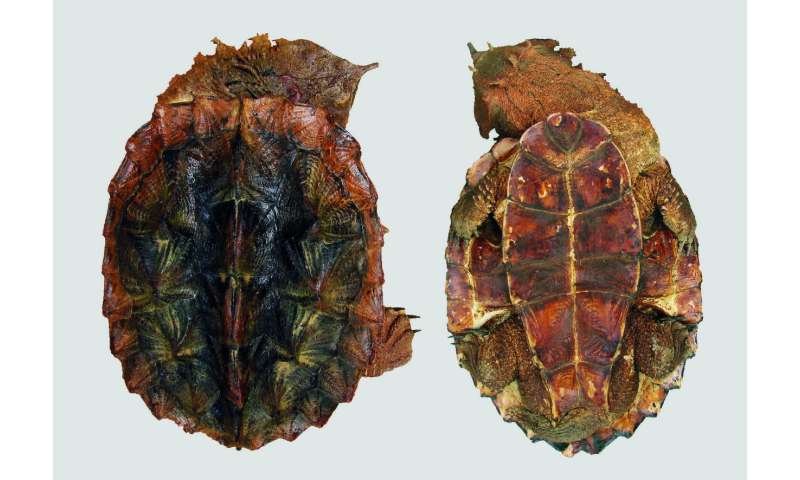
The newly described species Chelus orinocensis is found in the Orinoco and Río Negro basins. Credit: Mónica A. Morales-Betancourt

Using 75 DNA samples, the researchers were able to show that, contrary to previous assumptions, there are two genetically and morphologically well-differentiated species of mata mata turtles. The newly described species Chelus orinocensis inhabits the Orinoco and Río Negro basins, while the species known as Chelus fimbriata is restricted exclusively to the Amazon basin.

According to the study, the two species split during the late Miocene, around 13 million years ago. During this period, the former Amazon-Orinoco Basin began separating into the two river basins known today. Numerous aquatic animal species were thus spatially separated and began to diverge genetically.

The description of the new species also necessitates a reassessment of the mata mata's conservation status. "To date, this species was not considered endangered, based on its widespread distribution. However, our results show that, due to the split into two species, the population size of each species is smaller than previously assumed. In addition, every year, thousands of these bizarre-looking animals end up in the illegal animal trade and are confiscated by the authorities. We must protect these fascinating animals before it is too late," adds the study's lead author, Professor Mario Vargas-Ramírez, a former researcher of Senckenberg who now works at the National University of Colombia in Bogotá.

Explore furtherNewly discovered turtle species is facing extinction

More information: Mario Vargas-Ramírez et al. Genomic analyses reveal two species of the matamata (Testudines: Chelidae: Chelus spp.) and clarify their phylogeography, Molecular Phylogenetics and Evolution (2020). DOI: 10.1016/j.ympev.2020.106823
Video: The muddle in the middle-Pleistocene
by Wits University

Credit: CC0 Public Domain

During the late middle Pleistocene—between 400 000 and 150 0000 years ago—the populations occupying Earth, and Africa specifically, looked very differently from what they do now. There is evidence for at least three forms of human relatives inhabiting Africa, including Homo heidelbergensis, Homo naledi and Homo sapiens (modern humans).

Some, or all of these hominids made tools such as those associated with the middle stone age culture that began around 305 000 years ago. The question is, which of these human relatives got so crafty? Traditionally, it is thought that the larger brained species like Homo heidelbergensis and Homo sapiens should be associated with more complicated tool kits. But the answers may not be so simple. With three forms of early human relatives around, things are much more complicated, explains Professor Lee Berger.

'Dino Cave' reveals dinosaur crouch walkers


'Dino Cave' reveals dinosaur crouch walkers
Credit: University of Queensland
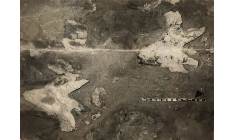
Old photos from Mount Morgan's sealed off "Dino Cave' have shed light onto new and unusual Aussie dinosaur behaviours, thanks to University of Queensland research.
For a decade, a Mount Morgan cave in central Queensland known for the highest dinosaur track diversity on the entire eastern half of Australia has been closed to the public, restricting research to the site.
Although UQ palaeontologist Dr. Anthony Romilio has had success searching for images of the tracks, he has only recently been provided with new images of different dinosaur's footprints at the site by the Mount Morgan Historical Museum.
"These photographs of fossil footprints have been on museum-display for years," Dr. Romilio said.
"Up until now, it was unknown what type of  made these tracks or what the tracks meant.
"A typical dinosaur track of this kind look like those made by birds, but these are shaped like broad-handled forks."
Upon further inspection, Dr. Romilio revealed that the dinosaur must have created the tracks while crouched.
"It's very strange behaviour, and we don't yet know why it did this," Dr. Romilio said.
"You can rule out predatory stalking behaviour, as this set of tracks was made by a two-legged plant eater called an ornithopod.

'Dino Cave' reveals dinosaur crouch walkers
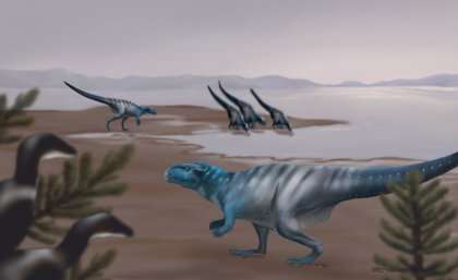
Reconstruction of Mount Morgan dinosaur track-makers on their ancient landscape. Credit: Dr Anthony Romilio
"And interestingly, this crouching dinosaur was taking bigger steps than other 'normal' walking dinosaurs.
"This unusual posture likely made the prehistoric animal more stable allowing them to quickly cross the muddy shore of an ancient lake."
Dr. Romilio is keen to investigate this mysterious dinosaur despite all of the unknowns.
"There are nine sites in the "Dinosaur Caves' that contain fossil footprints," Dr. Romilio said.
"Where exactly these photos were taken, and when, we just don't know.
"Many of the Mount Morgan track sites were mapped in the early 2000s, although these footprints don't appear on any of them.
"It may be that these fossils had already eroded, making these, and other old photos like them, so incredibly important, as they're our only record of these creature's existence."
The research has been published in Historical Biology.
Solved: The mystery surrounding dinosaur footprints on a cave ceiling

More information: Anthony Romilio. Additional notes on the Mount Morgan dinosaur tracks from the Lower Jurassic (Sinemurian) Razorback beds, Queensland, Australia., Historical Biology (2020). DOI: 10.1080/08912963.2020.1755853
Tomanowos: The meteorite that survived mega-floods and human folly

by Daniel Garcia-Castellanos, The Conversation

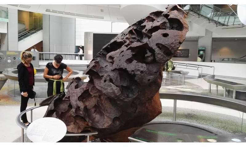
Surface detail of the Tomanowos meteorite, showing cavities produced by dissolution of iron. Credit: Eden, Janine and Jim/Wikipedia, CC BY

The rock with arguably the most fascinating story on Earth has an ancient name: Tomanowos. It means "the visitor from heaven" in the extinct language of Oregon's Clackamas Indian tribe.


The Clackamas revered the Tomanowos—also known as the Willamette meteorite – believing it came to unite heaven, earth and water for their people.

Rare extraterrestrial rocks like Tomanowos have a kind of fatal attraction for us humans. When European Americans found the pockmarked, 15-ton rock near the Willamette River more than a century ago, Tomanowos went through a violent uprooting, a series of lawsuits and a period under armed guard. It's one of the strangest rock stories I've come across in my years as a geoscientist. But let me start the tale from its real beginning, billions of years ago.

History of a rock

Tomanowos is a 15-ton meteorite made, as most metal meteorites are, of iron with about 8% nickel mixed in. These iron and nickel atoms were formed at the core of large stars that ended their lives in supernovae explosions.

Those massive explosions spattered outer space with the products of nuclear fusion—raw elements that then ended up in a nebula, or cloud of dust and gas.

Eventually the elements were forced together by gravity, forming the earliest planet-like orbs, or protoplanets of our solar system.
Supernovae disperse the iron produced in heavy stars. Credit: NASA

Some 4.5 billion years ago, Tomanowos was part of the core of one of these protoplanets, where heavier metals like iron and nickel accumulate.

Some time after that, this protoplanet must have collided with another planetary body, sending this meteorite and an unknowable number of other chunks back out into space.

Riding the flood

Subsequent impacts over billions of years eventually pushed Tomanowos' orbit across that of the Earth. As a result of this cosmic billiards game, the Tomanowos meteorite entered Earth's atmosphere around 17,000 years ago and landed on an ice cap in Canada.


Over the following decades, flowing ice slowly transported Tomanowos southwards, towards a glacier in the Fork River of Montana in what is now the United States. This glacier had created a 2,000-foot-high ice dam across the river, impounding the enormous Lake Missoula upstream.

The ice dam crumbled when Tomanowos was nearing it, releasing one of the largest floods ever documented: the Missoula Floods, which shaped the Scablands of Washington State with the power of several thousand Niagara Falls.

Trapped in ice and rafted down river by the flood, Tomanowos crossed modern-day Idaho, Washington and Oregon along the swollen Columbia River at speeds sometimes faster than 40 miles per hour, according to simulations by modern geologists. While floating near what's now the city of Portland, the meteorite's ice case broke apart, and Tomanowos sank to the river bottom.

It is one of hundreds of other "erratic" rocks—rocks made of elements that do not match the local geology—that have been found along the Columbia River. All are souvenirs from the cataclysmic Missoula floods, but none is as rare as Tomanowos.
Geological evidence of the Missoula Flood includes prairie ripple marks and layered silt deposits.

A rock worth suing for

As flood waters ebbed, Tomanowos was exposed to the elements. Over thousands of years, rain mixed with iron sulfide in the meteorite. This produced sulfuric acid that gradually dissolved the exposed side of the rock, creating the cratered surface it bears today.

Several thousand years after the Missoula floods, the Clackamas arrived to Oregon and discovered the meteorite. Did they know it came from the heavens, despite the lack of a crater? The name Tomanowos, or Visitor from the Sky, suggests that they may have suspected the rock's extraterrestrial origins.

Millennia of peaceful rest in the Willamette valley ended in 1902 when an Oregon man named Ellis Hughes secretly moved the iron rock to his own land and claimed it as his property.

Hauling a 15-ton rock on a wooden cart for nearly a mile without being noticed wasn't easy, even in the Wild West. Hughes and his son labored for three back-breaking months. Once the meteorite was on his land, he began charging admission to view the "Willamette Meteorite."

In fact, however, the legitimate owner of the iron rock turned out to be the Oregon Iron and Steel Company, which owned the land where Hughes had found the meteorite and sued for its return. While the suit worked its way through the courts, the company hired a guard who sat atop Tomanowos 24 hours a day with a loaded gun. They won the case in 1905, and sold Tomanowos to the American Museum of Natural History in New York a year later.
Present display of the Tomanowos meteorite, American Museum of Natural History. Credit: Daniel Garcia-Castellanos, CC BY-ND

Floods

Today Tomanowos can be seen in the museum's Hall of the Universe exhibition, which still refers to it as the Willamette Meteorite. In 2000 the museum signed an agreement with descendants of the Clackamas tribe, recognizing the meteorite's spiritual significance to the Native people of Oregon.

The Confederated Tribes of Grand Ronde hold an annual ceremonial visit with the ancient rock that, as their ancestors so aptly observed, brought the sky and the water together here on Earth. In 2019 several fragments of the meteorite that had been held separately were returned to the tribe.

But the museum's written display tells only some of the rock's long story. It omits the Missoula Floods, despite the significance of this event for modern earth science.

Decades after geologists J. Harlen Bretz and Joseph T. Pardee separately posited the theory of the Missoula floods in the early 20th century, their research was used to explain how Tomanowos reached Oregon, where it was found. Their work also triggered one of the most significant paradigm shifts in recent geoscience: the recognition that catastrophic flooding events significantly contribute to the erosion and evolution of landscape

Previously, scientists had followed Lyell's principle of uniformitarianism, which held that Earth's landscape was sculpted by regular, natural processes distributed evenly over long times. Normal floods fit into this theory, but the notion of swift, catastrophic events like the Missoula Floods were somewhat heretic.

The idea of huge Ice Age floods helped geologists a century ago prevail over pre-scientific, religious explanations for unusual finds—such as how marine fossils could be found at high elevation, and how a giant metal rock from outer space came to rest in Oregon.


Explore furtherRock used as doorstop is actually a meteorite worth $100K

Provided by The Conversation

Delivering animal vaccines and antibodies to protect humans from diseases like COVID-19

Delivering animal vaccines and antibodies to protect humans from diseases like COVID-19
Credit: Vdjokich, Shutterstock
Zoonoses—diseases that can spread between animals and humans, like avian influenza, rabies and severe acute respiratory syndrome—comprise a large percentage of all newly identified infectious diseases. As they represent a persistent global threat to public health, scientists are striving to develop strategies that effectively tackle widespread outbreaks, such as the novel coronavirus disease (COVID-19).
The EU-funded ZAPI project was at the forefront of this endeavor. Launched in March 2015, it has focused on establishing a swift response to major new infectious disease threats in Europe and across the world. It did so by designing new manufacturing processes for delivering effective and rapid control tools (vaccines, antibodies) against (re-)emerging  with pandemic potential. Bringing together human and veterinary research institutions, NGOs, , expert academic groups, and vaccine and biotech manufacturers, ZAPI used the "One Health' approach. According to the World Health Organization (WHO), the One Health approach involves designing and implementing programs, policies, legislation and research in which several sectors work together to achieve better  outcomes. A WHO Q&A document states: "Many of the same microbes infect animals and humans, as they share the eco-systems they live in. Efforts by just one sector cannot prevent or eliminate the problem. For instance, rabies in humans is effectively prevented only by targeting the animal source of the virus (for example, by vaccinating dogs)."
Using recent zoonotic models
ZAPI, which has worked on tackling outbreaks like those caused by coronavirus, used three different prototype models of diseases appearing in recent years that are zoonotic in nature. These are Middle East respiratory syndrome coronavirus (MERS-CoV), Schmallenberg virus (SBV) and Rift Valley fever virus (RVFV). MERS-CoV, causing severe lower respiratory tract disease in humans, was first identified in Saudi Arabia in 2012. Dromedary camels are a major animal source of infection in humans. RVFV, which is transmitted by mosquitoes, primarily affects animals but also has the capacity to infect humans. SBV is a novel Orthobunyavirus that has been associated with  in ruminants (cattle, sheep and goats) and was initially reported in 2011 in Europe. It's unlikely that SBV may pose a risk to humans, according to the European Centre for Disease Prevention and Control. MERS-CoV and SARS-CoV-2, the virus responsible for the COVID-19 pandemic, are genetically related, as noted in a news item.
In the same news item, Jean-Christophe Audonnet from project coordinator Merial Animal Health Ltd, part of the Boehringer Group of Companies since 2017, says: "A platform is a generic methodology or technology that can be used for multiple targets; in the case of vaccines, the only thing that will change will be the immunogen. It's an assembly of different components, so the way we manufacture the vaccine will always be the same." He adds that although it's unlikely to produce technology that can address every single new virus, "the ZAPI system design is flexible enough to address about 90% of all the targets that we can face."
The outcomes of ZAPI (Zoonotic Anticipation and Preparedness Initiative) can be directly applied to SARS-CoV-2, according to Dr. Audonnet. "It's a real life experiment now for us. A factor that we need to explore better through dialog is how we can reduce the timelines for the key decisions—political and regulatory ones," he says.
Studying animal coronavirus defences is opening route to human treatments

More information: ZAPI project website: http://zapi-imi.eu/

Long-term efficacy of managed wildfires in restoration efforts

wildfire
Credit: CC0 Public Domain
Land managers are increasingly interested in using lightning-ignited wildfires as a tool to restore forests and reduce fuel loads. But little is known about the effectiveness of managing wildfires to meet restoration goals.
For several years, ecologists at the Ecological Restoration Institute at Northern Arizona University have been working to better understand ecological outcomes of wildfires managed to achieve resource objectives and conditions under which practitioners can expect beneficial results.
A new article in the International Journal of Wildland Fire contributes to this line of research by testing the  of managed wildfire on three different  types (pine-oak, mixed-conifer, and spruce fir).
To examine the long-term impacts of  applications, a team of ERI-NAU ecologists remeasured permanent monitoring plots on the North Rim of Grand Canyon National Park 12 years after three wildfires were allowed to burn to meet resource objectives in 2003. The ecologists evaluated fire outcomes and measured effects on forest structure—for example, tree density—and species composition (the relative numbers of different tree species) over time.
Mike Stoddard, an ERI senior research specialist and lead author of the study, said managing for forests that are resilient to  and severe fire can require bold management to overcome more than a century of fire exclusion. But, he added, it is important that these management decisions are informed by science.
And while wildfires managed under mild weather conditions may be less expensive than other treatment methods, like mechanical thinning or prescribed fire, more research is needed to understand tradeoffs between methods in terms of ecological outcomes.
"Wildfires can accomplish a range of management objectives and some may build resilience to a changing climate, at least in the short-term," Stoddard said. "However, delayed effects on tree mortality and tree regeneration may shift our perception of the efficacy of fire treatment."
Overall, the 2003 resource objective wildfires in Grand Canyon National Park achieved several beneficial management outcomes, but researchers say there is much more to learn about the effectiveness of wildfires at accomplishing restoration objectives and promoting resilient forest conditions, particularly in less-remote areas.
Mixed-conifer forests at risk for high-severity wildfire

More information: Michael T. Stoddard et al. Ecosystem management applications of resource objective wildfires in forests of the Grand Canyon National Park, USA, International Journal of Wildland Fire (2020). DOI: 10.1071/WF19067

Climate change may push some species to higher elevations—and out of harm's way

Climate change may push some species to higher elevations -- and out of harm's way
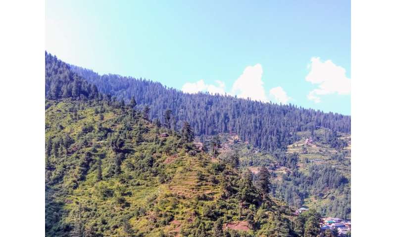
Human pressure from agriculture, livestock grazing, and development is often more intense at mountain bases, as in this Himalayan landscape in north India. Species shifting upslope tracking rising temperatures may find more intact habitats. Credit: Paul R. Elsen WCS
A new WCS-led study reveals that mountain-dwelling species fleeing warming temperatures by retreating to higher elevations may find refuge from reduced human pressure.
A new study published in Nature Communications by scientists at WCS, the University of California, Berkeley, and the United States Forest Service shows that nearly 60 percent of all mountainous area is under intense human pressure. Most of the pressure is at low elevations and mountain bases, which tend to be easier places for people to live, grow food, and build roads. The scientists then used  models to make predictions about how species would move under climate change. Based on their predictions, they found that species tend to move to higher elevations, and that these higher elevations tend to have more intact land for species because there is less human pressure.
Without factoring in human pressure, the authors warn that conservation actions may be misguided. Factoring in human pressure reveals the true 'shape' of a mountain for species that are restricted to intact landscapes, which are often the species of greatest conservation concern. Here, the 'true shape' refers to how much land area is potentially available as habitat for a species as it moves up in , not simply how much total land area is available. The true shape can reveal where species will tend to lose versus gain intact land area as they shift under climate change: the elevations where species are expected to lose area represent the priority zones for conservation.
Mountains are home to over 85 percent of the world's amphibians, birds, and mammals, making them global conservation priorities. But mountain-dwelling species are at risk from human activities, such as agriculture, livestock grazing, and development that reduce their habitat, and climate change that threatens to push species upslope as they struggle to find tolerable temperatures.
"Species are adapted to certain  conditions. As temperatures warm in mountains, scientists have documented species moving to higher elevations to maintain the same temperatures," said Paul Elsen, a WCS Climate Adaptation Scientist and lead author of the study. "This was always seen as a problem, because species would have less land area and less habitat to occupy at high elevations. But what we found is that as species move upslope, they tend to move away from areas that are already under intense human pressure and into areas with reduced human pressure. As a result, they can occupy more intact land area, even if the total amount of land area declines."
The authors combined several global databases to make their assessments: high-resolution digital elevation models gave a picture about how much surface area is available at different elevations. The Human Footprint Index provided information on pressure from human activities. Global  projected how temperatures are likely to change by the late 21st century.
The authors then used  to place hundreds of thousands of hypothetical 'species' across all  at different elevations and then predicted how they would shift their ranges based on climate projections. For each simulation, they compared the amount of area the species had to begin with to the amount they would have after the range shift under climate change.
Said Elsen: "We were surprised to find that many species had more intact land area available after the range shift compared to when they started."
The results suggest that many species in mountain ranges may have more intact land area available in the future if they track warming temperatures to higher slopes, though there were exceptions.
"Our results offer a glimmer of hope for montane species under ," Elsen said. "Montane species are still facing tremendous human pressure, especially at low elevations, but we have the opportunity now to protect intact habitats at  to give these  the best possible chance going forward."

More information: Paul R. Elsen et al, Topography and human pressure in mountain ranges alter expected species responses to climate change, Nature Communications (2020). DOI: 10.1038/s41467-020-15881-x
Journal information: Nature Communic

How to benefit from food waste in the age of climate change

Wasted food
Credit: CC0 Public Domain
Humanity bounces from one crisis to another as history shows us. Food waste and climate change are perhaps part of the same crisis. Now, research published in the International Journal of Global Warming suggests that finding secondary uses for food waste might reduce the overall impact of this problem.
Mustafa Özilgen and colleagues at Yeditepe University, in Istanbul, Turkey, explain how the issue is a self-perpetuating problem: "Global warming increases the food ; in return, the food waste causes further increase in ," they say. Remedies that have been suggested at least for kitchen waste suggest that burning such waste instead of fossil fuels might help. The team has now used thermodynamic calculations to show that food waste from a fast food outlet after compression and drying to produce one ton of waste could be used to generate 3.5 gigawatts.
They have estimated that all the fruit and vegetable waste in Turkey, including agricultural waste, could produce 7.2 gigajoules of energy each year. Of course, part of the problem of food waste is the plastic and paper packaging and some of this will be a component of the overall dried and compressed material from the .
"Our analysis indicates that trying to find a secondary use for food waste is not a feasible process, when compared with electric power production via combustion in a Rankine cycle with regeneration," the team reports. There may well be niche secondary uses for normally inedible fruit peel, vegetable stems, and other unusable plant materials that do not simply involve burning them for energy, but thermodynamically we would benefit more from burning such  instead of fossil fuels.
Consumers may be wasting more than twice as much food as commonly believed

More information: Sungur Kaan Gökbulak et al. How to benefit from the food waste in the era of global warming, International Journal of Global Warming (2020). DOI: 10.1504/IJGW.2020.106595

Assessing El Niño's impact on fisheries and aquaculture around the world

Assessing El Niño's impact on fisheries and aquaculture around the world
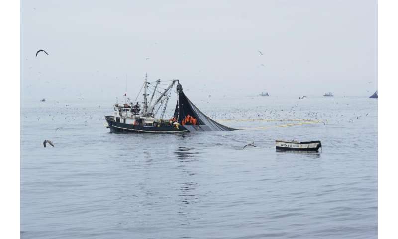
Peruvian industrial purse seiners in full activity of anchovy fishing. Credit: IRD - Arnaud Bertrand
While considerable resources are invested in seasonal forecasts and early-warning systems for food security, not enough is known about El Niño's impact on the fisheries and aquaculture sectors, even though its name was given in the 1600s by fishers off the coast of Peru.
To remedy that, FAO is publishing, in partnership with French National Research Institute for Sustainable Development (IRD France), the report El Niño Southern Oscillation (ENSO) effects on fisheries and aquaculture. This report captures the current state of knowledge on the impacts of ENSO events across sectors, from  to safety at sea, from fish biology and fishing operation to management measures.
El Niño is widely known as a climate pattern that begins over the Pacific Ocean but wreaks havoc on ecosystems in land and water far away from its origin. Its consequences include droughts and major harvest shortfalls in large swatches of Africa and Indonesia, forest fires in Australia, and serious flooding in South America.
ENSOs are often simplified to reflect two main phases: El Niño, an anomalous warming phase in the central and/or eastern equatorial Pacific Ocean, and an opposite cooling phase called La Niña.
In the former phase, a thickened surface layer of warm water prevents cold and nutrient-rich deep ocean water to reach the surface layer where photosynthesis occurs, putting a break on ocean production. This lowers the availability of food to local fish species such as anchoveta, which in turn either migrate southwards or suffer a productivity collapse.
While understanding of ENSOs has developed greatly since the 1950s, researchers have also been stymied as its incidences are rarely similar. Adding to the complexity is that the frequency and intensity of these events appear to have intensified in the past two decades, with some climate models suggesting these trends may continue as the climate changes.
"ENSO is not just a binary phenomenon (either warm or cold). Every ENSO event is different in signal, intensity, duration, and so are their consequences," says Arnaud Bertrand,  at IRD, who coordinated the report. "Understanding the diversity is key to developing predictive and preparatory capacities".
Key points :
International experts based in Chile, France and Peru were recruited to produce this report. It addresses successively the diversity of ENSO events; ENSO forecasting; ENSO in the context of climate change; global overview of ENSO impacts; Assessment of regional ENSO impacts on marine capture fisheries; coral bleaching and damage to reefs and related fisheries; ENSO and aquaculture; ENSO and inland capture fisheries.
Five broad types of ENSO were identified:
  • Extreme El Niño, Moderate Eastern Pacific (EP) El Niño, Moderate Central Pacific (CP) El Niño, Coastal El Niño, Strong La Niña. The authors also recognize that these five types are not static. ENSO events generally worsen with the effects of  on fish and fisheries, but the evidence is not yet conclusive enough.
  • For marine fisheries, the volume as well as the dominant species in fish catches can change dramatically depending on the type of ENSO. While the bulk of the net change is on Eastern Pacific fisheries, there are notable impacts on some fish populations in the Atlantic Ocean and some impact on tuna fisheries in the Indian Ocean. Further analysis of  and sizes could shed light on longer-term effects as ENSO events alter habitats and marine food webs long after they are over.
  • Fostering nimble fishing techniques can contribute to resilience, as Peruvian fishers showed when they adjusted to catch more shrimp that moved into warmer waters and thus offset the missing anchoveta. At the same time, the authors note that El Niño events do not necessarily favour alternative species productivity of sardine and mackerel populations but rather increase their susceptibility to capture—relevant information for fisheries management systems in operation.
  • Evidence also suggests that ENSO events can significantly impact aquaculture output, particularly for marine plants, mollusks and crustaceans, while triggering shifts to more drought-resistance species in inland fisheries in countries such as Uganda.
  • Currently, reasonable forecasts can be made up to six months in advance, but with very little ability to predict which (ENSO) type will occur. ENSO has important impacts on cyclonic activity, ocean conditions or precipitation.
The authors conclude the report with perspectives for ENSO preparedness in a warmer world.
El Niño-Southern Oscillation heat engine shifts eastward under global warming

More information: Bertrand A et al. El Niño Southern Oscillation (ENSO) effects on fisheries and aquaculture, FAO Fisheries and Aquaculture Technical Papers (2020). DOI: 10.4060/ca8348enhttp://www.fao.org/documents/card/en/c/ca8348en/

COVID-19: the rise of a global collective intelligence?

COVID-19: the rise of a global collective intelligence?
Network of Covid-19 projects on the JOGL platform. Credit: Marc Santolini/JOGL, Author provided
All around the world, scientists and practitioners are relentlessly harnessing data on the pandemic to model its progression, predict the impact of possible interventions and develop solutions to medical equipment shortages, generating open-source data and codes to be reused by others.
Research and innovation is now in a collaborative frenzy just as contagious as the coronavirus. Is this the rise of the famous "" supposed to solve our major global problems?
The rise of a global collective intelligence
The beginning of the epidemic saw "traditional" research considerably accelerate and open its means of production, with journals such as ScienceNature and The Lancet immediately granting public access to publications on the coronavirus and COVID-19.
The academic world is in ebullition. Every day, John Hopkins University updates an open and collaborative stream of data on the epidemic, which have already been reused more than 11,000 times. Research results are published immediately on pre-print servers or laboratory websites. Algorithms and interactive visualizations are flourishing on GitHub; outreach videos on YouTube. The figures are staggering, with nearly 9,000 academic articles published on the subject to date.
More recently, popular initiatives bringing together a variety of actors have emerged outside institutional frameworks, using . For example, a community of biologists, engineers and developers has emerged on the Just One Giant Lab (JOGL) collaborative platform to develop low-cost, open-source solutions against the virus. This platform, which we developed with Leo Blondel (Harvard University) and Thomas Landrain (La PaillassePILI) over the past three years, is designed as a virtual, open and distributed research institute aimed at developing solutions to the Sustainable Development Goals (SDGs) defined by the United Nations. Communities use it to self-organize and provide innovative solutions to urgent problems requiring fundamentally interdisciplinary skills and knowledge. The platform facilitates coordination by linking needs and resources within the community, animating research programs, and organising challenges.
When the first project related to COVID-19—a low-cost, open source diagnostic test—was born in early March, there was a rush on the platform. The number of contributions per minute kept increasing: hundreds of interactions, project creation, communications… So much so that the server hosting the platform couldn't hold anymore! In only one month, there were more than 60,000 visitors coming from 183 countries, including 3,000 active contributors generating more than 90 projects, ranging from mask designs to low-cost ventilator prototypes, or cough-classification AI apps.
This massive community quickly self-organized into working groups, mixing different skills and universes; unexpected combinations of data scientists from large companies, researchers in anthropology, engineers or biologists come together in this virtual universe.
The most active person and emerging coordinator of the community even turns out to be… a 17-year-old high school student from Seattle! This initiative is now a full-fledged research program, OpenCOVID19, with 100,000 euros of funding from the Axa Research Fund currently redistributed as micro-grants to emerging projects through a community peer-review system, a partnership with the Paris hospital system (AP-HP) to facilitate the evaluation and validation of designs intended for hospital use, and several major themes: diagnosis, prevention, treatment, validation, and data analysis and modelling.
The open-source world has in the past decades spearheaded community self-organization and is at the origin of massive collaborative projects such as Linux or Wikipedia. Similar efforts are now emerging to solve global and multi-disciplinary issues, leveraging skill diversity at the service of project complexity.
COVID-19: the rise of a global collective intelligence?
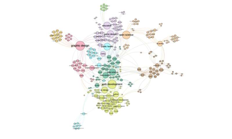
Map of shared skills across Covid-19 projects on the JOGL platform. Credit: Marc Santolini, JOGL, CRI, Author provided
What is "collective intelligence"?
If we can measure individual intelligence using performance indicators for various tasks and deriving individual "IQ", why not measure the intelligence of a group through their performance on collective tasks?
Researchers have exhibited the existence of a collective intelligence factor. It turns out that an intelligent group is not a group of intelligent individuals, but rather a group of individuals who interact efficiently—for example though their ability to speak equitably in discussions. The authors conclude: "it would seem to be much easier to raise the intelligence of a group than an individual. Could a group's collective intelligence be increased by, for example, better electronic collaboration tools?".
This is the spirit of collaborative platforms such as JOGL: we can monitor in real time community evolution and project progress, allowing to facilitate the coordination of the various programs, including OpenCOVID19.
The generated data also provide a quantitative ground to explore "good practices" facilitating collective intelligence. By analysing it with the tools of network science, we study how collaborative dynamics underpin the advancement of knowledge.
Ephemeral awakening or long-term revolution?
While it is too early to draw conclusions in the case of the OpenCOVID19 program, designing the future of such massive collaborations starts now. In particular, members of communities that scale up quickly often get lost, and smart onboarding strategies are key to sustaining such efforts. The grail of these communities resides in building an architecture of attention through recommender systems, the same algorithms that made the success of social networks such as Twitter, Instagram or Facebook. This approach, based on fundamental results from team science and network science, leverages the digital traces of the community to suggest the best person to contact, the most relevant project to help or pressing task to complete. At the heart of the JOGL architecture, such algorithms help promote serendipity and facilitate coordination.
Developing recommender systems for massive collaborations requires vastly diverse contributions, from computer science to social sciences, mathematics or ethics. Ironically, collective  will be the key to its own design.
Five ways collective intelligence can help beat coronavirus in developing countries
Journal information: Science , Nature , The Lancet 
Provided by The Conversation