Thursday, August 19, 2021

Tremors strike Haitian city still reeling from quake

Authorities say the official death toll has risen to 2,189 following the earthquake in the country’s south.

Thousands of people were injured in the August 14 earthquake and the death toll has now risen to 2,189 [Orlando BarrĂ­a/EPA]

19 Aug 2021

Fresh tremors shook buildings late on Wednesday in the southern Haitian city of Les Cayes, a Reuters witness said, a few days after a devastating earthquake killed almost 2,200 people across the Caribbean nation and injured thousands more.

A police officer on patrol in Les Cayes said there were no immediate reports of further deaths or damage in the region, which is still reeling from the 7.2 magnitude earthquake on Saturday morning.

KEEP READING
Haiti quake death toll rises as crews scramble to find survivors

Across the seaside city, families were sleeping on mattresses in the streets.

Haitian authorities said late on Wednesday that the official death toll from the quake had risen to 2,189.

The poorest country in the Americas, Haiti is still recovering from a 2010 quake that killed over 200,000.

‘On its knees’

Prime Minister Ariel Henry said that the quake had left Haiti “on its knees”, as survivors showed increasing frustration about the sluggish arrival of relief in hard-hit areas.

Henry had promised a rapid increase in aid. But in a video address on Wednesday evening, he conceded that the Caribbean nation was in trouble.

“The earthquake that devastated a large part of the south of the country proves once again our limits, and how fragile we are,” said Henry.

Dozens of people went to Les Cayes airport demanding food after a helicopter arrived carrying supplies, a witness told the Reuters news agency. Police intervened to allow a truck carrying aid to leave.

Following another night of rains, residents in Les Cayes, including those camped in a mushrooming community of tents in the city centre, complained of scant assistance.


Concern was also growing for more remote places outside Les Cayes such as Jeremie to the northwest, where access roads were damaged, videos on social media showed.


Pierre Cenel, a judge in Les Cayes, rebuked the government in Port-au-Prince.

“As a judge, I must not have a political opinion. But as a man, as a man concerned about the situation of my country, nothing is working. They didn’t do anything to prepare for this disaster,” Cenel said
.Residents look on as workers receive humanitarian aid from a US helicopter at Les Cayes airport after Saturday’s magnitude 7.2 earthquake [Henry Romero/Reuters]

The poorest country in the Americas, Haiti is still recovering from a 2010 quake that killed more than 200,000 people. The latest disaster hit just weeks after President Jovenel Moise was assassinated on July 7, plunging Haiti into political turmoil.

Jerry Chandler, the head of Haiti’s civil protection agency, told a news conference he knew aid had yet to reach many areas but officials were working hard to deliver it.

“The frustration and despair of the population is understood, but … the population is asked not to block the convoys so that civil protection can do its job,” he said.

There were at least 600,000 people in need of humanitarian assistance and 135,000 families displaced, Chandler said. The goal was to deliver aid to everyone in need within a week.

Risk of disease

In the tent city in Les Cayes displaced residents were getting worried.

“We need help,” said Roosevelt Milford, a pastor speaking on radio on behalf of the hundreds camping out in soggy fields since the quake destroyed their homes.

Milford and others said they lacked even the most basic provisions, such as food, clean drinking water and shelter from the rain. Tanks of drinking water were destroyed during the earthquake, authorities said.

Tropical Storm Grace this week swept away many shelters and inundated the field.

Moril Jeudy, a community leader in Marigot area, south of Port-au-Prince, said while the town had emerged intact from the earthquake, Grace had flooded hundreds of homes, killed four people and left several more missing. And no help had arrived yet.


“Even the NGOs didn’t come,” he said.

Security concerns about gang-controlled areas on the route from the capital Port-au-Prince, have slowed aid access.
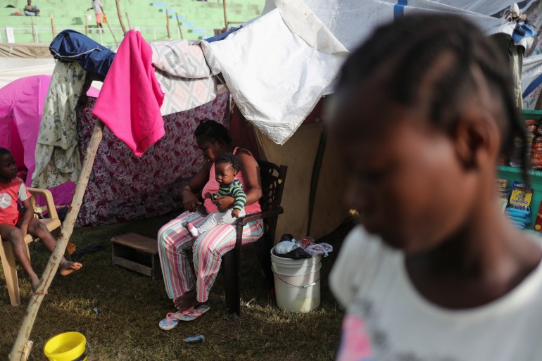
A woman sits with her child at a stadium used as a shelter for residents who were evacuated from their damaged homes after Saturday’s 7.2 magnitude quake, in Les Cayes, Haiti August 18, 2021. [Henry Romero/Reuters]

The United Nations Office for the Coordination of Humanitarian Affairs said negotiations with armed groups had permitted a humanitarian convoy to reach Les Cayes.

Chandler said the government was increasing the number of aid convoys going by land, and aimed to reach three a day soon.

In L’Asile, a town of more than 30,000 people about 60km (40 miles) northeast of Les Cayes, community leader Aldorf Hilaire said government help had yet to arrive and survivors were relying on support from charities such as Doctors Without Borders.

“We are desperate,” he told Reuters. “The springs are dirty: the water is not drinkable … We had a bad night during the storm and the people need tents and tarps.”

In a rare piece of good news, 34 people had been rescued in the last two days, Chandler said. But hopes are fading.
SOURCE: REUTERS


Mapping wildfires around the world

From Siberia to Algeria, Al Jazeera looks at some of the largest and deadliest wildfires blazing around the world.

In recent weeks, the devastating effects of wildfires, which have killed more than 100 people and rendered thousands homeless, have been dominating headlines around the world.

Several countries have reported their worst fires in decades, including hundreds of deadly fires across the Mediterranean. In Algeria, at least 90 people have been killed.

California’s Dixie fire – the second-largest in the state’s history, and Siberia’s wildfires are being touted as some of the largest fires in recorded history.

According to the European Space Agency, “fire affects an estimated four million square kilometres (1.5 million sq miles) of Earth’s land each year”. To put that in context, that is about half the size of the United States, larger than India, or roughly four times the size of Nigeria.

To measure the size and impact these fires have on climate, vegetation and atmosphere, scientists use observations from several low Earth-orbit satellites, including the Copernicus Sentinel-3. It gathers shortwave-infrared data combined with other techniques to differentiate between burned areas and other low reflectance covers such as clouds.

Wildfires on the rise

While wildfires are a natural part of many environments as a way to clear out dead underbrush and restore nutrients, scientists have warned that they are becoming more frequent and more widespread

In August, an alarming UN report blamed human activity for “unprecedented” changes to the climate. Scientists from across the globe said humanity will experience more extreme weather in the coming years and will suffer the consequences of rising sea levels and melting Arctic ice.

Mark Diesendorf, associate professor at the University of New South Wales in Australia, told Al Jazeera climate change is producing heatwaves and droughts, which, in turn, create dry vegetation that fuels large fires.

According to the Center for Research on the Epidemiology of Disasters, at least 470 wildfire disasters – incidents that killed 10 or more people or affected more than 100 – have been reported globally since 1911, causing at least $120bn in damages.

Mediterranean wildfires

A heatwave across southern Europe, fed by hot air from Africa, has led to wildfires across the region. Hundreds of fires have raged from Algeria to Jerusalem in the past month.

Turkey

In Turkey, at least eight people have been killed since July 28 when hundreds of fires swept through the south. President Recep Tayyip Erdogan declared the regions affected by the fires as “disaster areas” and described them as the “worst wildfires” in the country’s history.

According to Husrev Ozkara, vice-chair of the Turkish Foresters Association, an average of 2,600 fires have erupted across the country every year during the last decade. In 2020, that figure jumped to almost 3,400.

Greece

In neighbouring Greece, more than 500 fires forced the evacuation of thousands of people as forests were scorched by wildfires in Evia, Peloponnese, and Attica, including around the capital Athens. Two people were reportedly killed and at least 20 others injured.

Prime Minister Kyriakos Mitsotakis said the fires in Greece are unmistakably linked “to the reality of climate change”.

A man stands in the water watching as wildfire approaches Kochyli Beach near Limni village on the island of Evia, August 6, 2021. [Thodoris Nikolaou/AP Photo]

Italy

In Italy, firefighters have battled more than 500 blazes in Sicily and the southern Calabria region. At least two people have died.

On August 12, a monitoring station in Sicily reported temperatures of 48.8C (119.8F) – levels some scientists believe could be the highest in European history. Christian Solinas, president of the Sardinia region, called the fires an “unprecedented disaster”.

France

Fires have also raged in the south of France, killing at least two people on Wednesday near Saint-Tropez, a resort region known for its forests, vineyards and tourism.

French President Emmanuel Macron, who had been holidaying nearby, visited the fire zone on Tuesday. He said the destroyed landscape was “absolutely terrible in terms of biodiversity and of natural heritage … but lives had been protected”.

Flames rise as the setting sun filters through the smoke of a forest fire near Gonfaron, Var 
[Nicolas Tucat/AFP]

Algeria

In Algeria, at least 90 people, including 33 soldiers, have been killed in wildfires, according to local authorities.

President Abdelmadjid Tebboune declared three days of national mourning for the deadliest fires in the nation’s history. Authorities have blamed arsonists and “criminals” for the outbreaks and arrested dozens.

Lebanon

In Lebanon, wildfires spread through the forests in the Akkar region in late July. A 15-year-old who was helping firefighters put out the blaze was killed.

Jerusalem

In Jerusalem, some of the worst fires in the region’s history were contained on Wednesday following a three-day firefight by Palestinian firefighters and the Israeli Air Force. No serious injuries were reported.

A plane disperses fire retardant as it helps extinguish a fire on the outskirts of Jerusalem,
 August 16, 2021 [Ammar Awad/Reuters]

Wildfires have also flared up around the Mediterranean basin, including in Spain, Portugal and Morocco.

California’s Dixie Fire

In the US, California’s Dixie Fire has been raging since mid-July. California fire authorities announced on Tuesday that the wildfire now spanned 253,637 hectares (626,751 acres) and remained 31-percent contained.

The fire is currently the second-largest blaze in California’s history and has destroyed more than 1,200 structures. It has burned an area larger than the city of Houston, Texas or at least twice the size of New York City.

Only the August Complex fire of 2020, which consumed more than 404,685 hectares (one million acres) in California, was larger.

In neighbouring Canada, hundreds of fires also swept across the country following record-setting temperatures in July.

Siberia wildfires

In Russia, uncontrollable blazes have consumed thousands of kilometres of Siberia’s vast coniferous forests in the country’s largest and coldest region.

According to  Alexey Yaroshenko, Greenpeace Russia’s forestry head, the largest of these fires has exceeded 1.5 million hectares (3.7 million acres) in size.

“This fire has to grow by about 400,000 hectares (988,000 acres) to become the biggest in documented history,” Yaroshenko said.

The environmental group bases its figures on statistics from Russia’s fire services.

According to the Washington Post, Siberia’s wildfires are now larger than the rest of the world’s blazes combined.

The deadliest fires in history

According to the Centre for Research on the Epidemiology of Disasters, since 1911, wildfires have killed at least 4,545 people, injured 11,379 and affected more than 17 million around the world.

Minnesota’s Cloquet fire of 1918 is the deadliest on record, killing an estimated 1,000 people (including those missing).

SOURCE: AL JAZEERA

Evgeny Sveshnikov, 1950-2021

The Russian-Latvian grandmaster, former world senior champion, chess opening

 revolutionary, writer, trainer, and outspoken GM  passed away at the age of 71. 

Evgeny Sveshnikov in 2016. Photo: Maria Emelianova/Chess.com.


PeterDoggers
Updated: Aug 18, 2021, 1
51|Chess Event Coverage

The Russian-Latvian grandmaster, former world senior champion, chess opening revolutionary, writer, trainer, and outspoken GM Evgeny Sveshnikov has passed away at the age of 71. 

His death came only a few months after his mother had died at the age of 97.

Evgeny Ellinovich Sveshnikov was born February 11, 1950, in Chelyabinsk, just east of the Ural mountains in Russia, then the Soviet Union. As a talented youngster, his early chess education included several lectures by the famous Soviet trainer Igor Bondarevsky. His main coach, who became a good friend, was Leonid Gratvol, himself a candidate master.

Sveshnikov's first major chess tournament was at age 17, when he played in the 35th edition of the Soviet Championship, held in December 1967 in Tbilisi, Georgia. For the first time, the tournament was held in the format of a 13-round Swiss with 130 players.

Just like for later GMs such as Lev Alburt, Boris Gulko, Genna Sosonko, and Rafael Vaganian, it was Sveshnikov's debut in the Soviet Championship as he scored a decent 7/13. GMs Lev Polugaevsky and Mikhail Tal shared first place.

Sveshnikov graduated in 1972 and began working as a research engineer in the Department of Internal Combustion Engines. In a ChessPro article dedicated to his 60th birthday, he was quoted about that period (translation by Chessbase):

"I worked in the laboratory for 10-12 hours a day. Under laboratory conditions, by changing the shape of the combustion chamber and increasing the degree of boost, we managed to get 100 horsepower from a single-cylinder engine of a tank. At the time the maximum was 45-50 hp. Today, tanks have 12 cylinders and 1,200 horsepower. All my life I will remember the saying of my boss, Dr. Gennady Borisovich Dragunov: 'The laws of physics are there to be circumvented by other laws.' At the time I decided to become a chess professional, I had almost finished my Ph.D. thesis on the shape of the combustion chamber."

Finally able to focus on chess, Sveshnikov won the All-Union Tournaments of Young Masters in 1973 and 1976 and also the All-Union Tournament in 1975. He tied for first place with GM Sergey Makarychev in the 1983 Moscow Championship.

He came in first or shared first in a number of international tournaments, such as Plovdiv (1973), Decin (1974), Sochi (1976, 1985), Le Havre (1977), Marina Romeo (1977), Cienfuegos (1979), and Hastings (1984/1985).

In team competitions, he scored several successes. In 1976, he was part of the gold medal-winning Soviet team at the World Student Team Championship. He then won both team and individual gold at the 1977 European Team Championship, the same year when FIDE awarded his GM title.

Evgeny Sveshnikov in 1981. 
Photo: Rob Bogaerts/Anefo/Dutch National Archives.

In the 1990s, Sveshnikov moved to Riga and started representing Latvia in Chess Olympiads. He played for that country in 2004, 2006, 2008, and 2010. He also played for Latvia in the European Team Championship in 2011.

In 2016, 40 years after he had done so as a student, Sveshnikov won team gold for Russia, this time in the 65+ section of the World Senior Team Championship. A year later, he also clinched the 65+ World Senior Chess Championship.

Sveshnikov also worked as a coach. For 10 years, he was one of the leaders of the All-Russian Chess School and later he headed many regional schools, in particular in the city of Satka, close to Chelyabinsk.

During his career, Sveshnikov beat several strong grandmasters, including GM Judit Polgar, GM Viktor Korchnoi, GM Nigel Short, and GM Mark Taimanov as well as drew with (future) world champions Viswanathan Anand, Garry Kasparov, Anatoly Karpov, Vasily Smyslov, and Mikhail Tal. Here's a selection:

A Cosmic Web Connects Everything in the Universe
Aug 18, 2021
Motherboard

From the surface of Earth it seems the stars and galaxies are randomly placed throughout the universe. But step back to a galactic scale, and a mysterious network of roads and hubs emerges. This is the Cosmic Web, and we are just beginning to learn how it underlies the nature of the cosmos. Mordecai-Mark Mac Low and Carter Emmart from the American Museum of Natural History take us on a tour of the Cosmic Web.


Mapping the universe's earliest structures with COSMOS-webb

Mapping the universe's earliest structures with COSMOS-webb
The COSMOS-Webb survey will map 0.6 square degrees of the sky—about the area of three full Moons—using the James Webb Space Telescope’s Near Infrared Camera (NIRCam) instrument, while simultaneously mapping a smaller 0.2 square degrees with the Mid Infrared Instrument (MIRI). The jagged edges of the Hubble field’s outline are due to the separate images that make up the survey field. Credit: Space Telescope Science Institute

When NASA's James Webb Space Telescope begins science operations in 2022, one of its first tasks will be an ambitious program to map the earliest structures in the universe. Called COSMOS-Webb, this wide and deep survey of half a million galaxies is the largest project Webb will undertake during its first year.

With more than 200 hours of observing time, COSMOS-Webb will survey a large patch of the sky—0.6 square degrees—with the Near-Infrared Camera (NIRCam). That's the size of three full moons. It will simultaneously map a smaller area with the Mid-Infrared Instrument (MIRI).

"It's a large chunk of sky, which is pretty unique to the COSMOS-Webb program. Most Webb programs are drilling very deep, like pencil-beam surveys that are studying tiny patches of sky," explained Caitlin Casey, an assistant professor at the University of Texas at Austin and co-leader of the COSMOS-Webb program. "Because we're covering such a large area, we can look at large-scale structures at the dawn of galaxy formation. We will also look for some of the rarest  that existed early on, as well as map the large-scale dark matter distribution of galaxies out to very early times."

(Dark matter does not absorb, reflect, or emit light, so it cannot be seen directly. We know that dark matter exists because of the effect it has on objects that we can observe.)

COSMOS-Webb will study half a million galaxies with multi-band, high-resolution, near-infrared imaging, and an unprecedented 32,000 galaxies in the mid infrared. With its rapid public release of the data, this survey will be a primary legacy dataset from Webb for scientists worldwide studying galaxies beyond the Milky Way.

Building on Hubble's achievements

The COSMOS survey began in 2002 as a Hubble program to image a much larger patch of sky, about the area of 10 full moons. From there, the collaboration snowballed to include most of the world's major telescopes on Earth and in space. Now COSMOS is a multi-wavelength survey that covers the entire spectrum from the X-ray through the radio.

Because of its location on the sky, the COSMOS field is accessible to observatories around the world. Located on the celestial equator, it can be studied from both the northern and southern hemispheres, resulting in a rich and diverse treasury of data.

"COSMOS has become the survey that a lot of extragalactic scientists go to in order to conduct their analyses because the data products are so widely available, and because it covers such a wide area of the sky," said Rochester Institute of Technology's Jeyhan Kartaltepe, assistant professor of physics and co-leader of the COSMOS-Webb program. "COSMOS-Webb is the next installment of that, where we're using Webb to extend our coverage in the near- and mid-infrared part of the spectrum, and therefore pushing out our horizon, how far away we're able to see."

The ambitious COSMOS-Webb will build upon previous discoveries to make advances in three particular areas of study, including: revolutionizing our understanding of the Reionization Era; looking for early, fully evolved galaxies; and learning how dark matter evolved with galaxies' stellar content.

Goal 1: Revolutionizing our understanding of the reionization era

Soon after the big bang, the universe was completely dark. Stars and galaxies, which bathe the cosmos in light, had not yet formed. Instead, the universe consisted of a primordial soup of neutral hydrogen and helium atoms and invisible dark matter. This is called the cosmic dark ages.

After several hundred million years, the first stars and galaxies emerged and provided energy to reionize the early universe. This energy ripped apart the hydrogen atoms that filled the universe, giving them an electric charge and ending the cosmic dark ages. This new era where the universe was flooded with light is called the Reionization Era.

The first goal of COSMOS-Webb focuses on this epoch of reionization, which took place from 400,000 to 1 billion years after the big bang. Reionization likely happened in little pockets, not all at once. COSMOS-Webb will look for bubbles showing where the first pockets of the early universe were reionized. The team aims to map the scale of these reionization bubbles.

"Hubble has done a great job of finding handfuls of these galaxies out to early times, but we need thousands more galaxies to understand the reionization process," explained Casey.

Scientists don't even know what kind of galaxies ushered in the Reionization Era, whether they're very massive or relatively low-mass systems. COSMOS-Webb will have a unique ability to find very massive, rare galaxies and see what their distribution is like in large-scale structures. So, are the galaxies responsible for reionization living in the equivalent of a cosmic metropolis, or are they mostly evenly distributed across space? Only a survey the size of COSMOS-Webb can help scientists to answer this.

Goal 2: Looking for early, fully evolved galaxies

COSMOS-Webb will search for very early, fully evolved galaxies that shut down star birth in the first 2 billion years after the big bang. Hubble has found a handful of these galaxies, which challenge existing models about how the universe formed. Scientists struggle to explain how these galaxies could have old stars and not be forming any new stars so early in the history of the universe.

With a large survey like COSMOS-Webb, the team will find many of these rare galaxies. They plan detailed studies of these galaxies to understand how they could have evolved so rapidly and turned off star formation so early.

Goal 3: Learning how dark matter evolved with galaxies' stellar content

COSMOS-Webb will give scientists insight into how dark matter in galaxies has evolved with the galaxies' stellar content over the universe's lifetime.

Galaxies are made of two types of matter: normal, luminous matter that we see in stars and other objects, and invisible dark matter, which is often more massive than the galaxy and can surround it in an extended halo. Those two kinds of matter are intertwined in galaxy formation and evolution. However, presently there's not much knowledge about how the dark matter mass in the halos of galaxies formed, and how that dark matter impacts the formation of the galaxies.

COSMOS-Webb will shed light on this process by allowing scientists to directly measure these dark matter halos through "weak lensing." The gravity from any type of mass—whether it's dark or luminous—can serve as a lens to "bend" the light we see from more distant galaxies. Weak lensing distorts the apparent shape of background galaxies, so when a halo is located in front of other galaxies, scientists can directly measure the mass of the halo's dark matter.

"For the first time, we'll be able to measure the relationship between the dark matter mass and the luminous mass of galaxies back to the first 2 billion years of cosmic time," said team member Anton Koekemoer, a research astronomer at the Space Telescope Science Institute in Baltimore, who helped design the program's observing strategy and is in charge of constructing all the images from the program. "That's a crucial epoch for us to try to understand how the galaxies' mass was first put in place, and how that's driven by the  halos. And that can then feed indirectly into our understanding of galaxy formation."

Quickly sharing data with the community

COSMOS-Webb is a Treasury program, which by definition is designed to create datasets of lasting scientific value. Treasury Programs strive to solve multiple scientific problems with a single, coherent dataset. Data taken under a Treasury Program usually has no exclusive access period, enabling immediate analysis by other researchers.

"As a Treasury Program, you are committing to quickly releasing your data and your data products to the community," explained Kartaltepe. "We're going to produce this community resource and make it publicly available so that the rest of the community can use it in their scientific analyses."

Koekemoer added, "A Treasury Program commits to making publicly available all these science products so that anyone in the community, even at very small institutions, can have the same, equal access to the data products and then just do the science."

COSMOS-Webb is a Cycle 1 General Observers program. General Observers programs were competitively selected using a dual-anonymous review system, the same system that is used to allocate time on Hubble.

The James Webb Space Telescope will be the world's premier space science observatory when it launches in 2021. Webb will solve mysteries in our solar system, look beyond to distant worlds around other stars, and probe the mysterious structures and origins of our universe and our place in it. Webb is an international program led by NASA with its partners, ESA (European Space Agency) and the Canadian Space Agency.

Image: Hubble's treasure chest of galaxie

Provided by Space Telescope Science Institute


ANOTHER PALLISER TRIANGLE DROUGHT HAPPENED THIS SUMMER 2021

Are the Great Plains Headed for Another Dust Bowl?

Researchers say atmospheric dust in the region has doubled in the last 20 years, suggesting the increasingly dry region is losing more soil skyward

dust bowl photo
Buried farm machinery in Dallas, South Dakota during the Dust Bowl in 1936. (United States Department of Agriculture)
SMITHSONIANMAG.COM


new study shows dust storms have become more common and more severe on the Great Plains, leading some to wonder if the United States is headed for another Dust Bowl, reports Roland Pease for Science. With nearly half the country currently in drought and a winter forecast predicting continued dry weather for many of the afflicted regions, dust storms could become an even bigger threat.

In the 1930s, the Dust Bowl was caused by years of severe drought and featured dust storms up to 1,000 miles long. But the other driving force behind the plumes of dust that ravaged the landscape was the conversion of prairie to agricultural fields on a massive scale—between 1925 and the early 1930s, farmers converted 5.2 million acres of grassland over to farming, reported Sarah Zielinski for Smithsonian magazine in 2012.

Hardy prairie grasses would have likely withstood the drought, but crops covering the newly converted tracts swiftly bit the proverbial dust, which loosened the grip their roots had on the soil. High winds then whipped that loose soil into the huge clouds that blanketed the landscape with dust, including 1935’s Black Sunday which lifted 300,000 tons of the stuff skyward.

Besides blotting out the sun, dust storms strip valuable nutrients from the soils, making the land less productive, and create a significant health hazard at a time when a respiratory illness is sickening people around the world, according to Science.

dust graphic
A graphic representing the hazards of increasing atmospheric dust. (Talie Lambert)

The new research, published earlier this month in the journal Geophysical Research Letters, used data from NASA satellites and ground monitoring systems to detect a steady increase in the amount of dust being kicked into the atmosphere every year, reports Brooks Hays for United Press International. The researchers found that levels of atmospheric dust swirling above the Great Plains region doubled between 2000 and 2018.

According to the paper, the increasing levels of dust, up to five percent per year, coincided with worsening climate change and a five to ten percent expansion of farmland across the Great Plains that mirrors the prelude to the Dust Bowl. Together, the researchers suggest these factors may drive the U.S. toward a second Dust Bowl.

“We can’t make changes to the earth surface without some kind of consequence just as we can’t burn fossil fuels without consequences,” says Andrew Lambert, a meteorologist at the U.S. Naval Research Laboratory and the paper’s first author, in a statement. “So while the agriculture industry is absolutely important, we need to think more carefully about where and how we plant.”

Part of what allowed Lambert and his colleagues to tie the added dust in the sky to agriculture were clear regional upticks when and where major crops such as corn and soybeans were planted and harvested, per the statement. Ironically, much of the grassland that was converted to agriculture in recent years was not for food but for corn destined to become fodder for biofuels intended to reduce reliance on fossil fuels, Lambert tells Science.

Human-caused climate change is also making the Great Plains hotter and drier. In April, a paper published in the journal Science said the Southwestern part of North America may be entering a megadrought worse than anything seen in 1,200 years.

“The current drought ranks right up there with the worst in more than a thousand years, and there’s a human influence on this of at least 30 percent and possibly as much as 50 percent in terms of its severity,” as Jason Smerdon, a paleoclimatologist at Columbia University’s Lamont Doherty Earth Observatory who co-authored the study, told Smithsonian magazine’s Brian Handwerk at the time.

Just last week, a large dust storm struck eastern Colorado, reports Jesse Sarles for CBS Denver.

“I think it’s fair to say that what’s happening with dust trends in the Midwest and the Great Plains is an indicator that the threat is real if cropland expansion continues to occur at this rate and drought risk does increase because of climate change,” Lambert says in the statement. “Those would be the ingredients for another Dust Bowl.”

About Alex Fox
Alex Fox

Alex Fox is a freelance science journalist based in Washington, D.C. He has written for ScienceNatureScience Newsthe San Jose Mercury News, and Mongabay. You can find him at Alexfoxscience.com.

Read more from this author | 
  • Drought in the Palliser Triangle - pfra.ca

    pfra.ca/doc/Drought/Drought in the Palliser Triangle_1998.pdf · PDF file

    Created Date: 7/20/2009 

  • Vulnerability and Adaptation to Drought: The Canadian ...

    https://prism.ucalgary.ca/bitstream/handle/1880/51490/Vulnerability_… · PDF file

    A History of Drought in the Palliser Triangle Given the extreme climate and water scarcity that marks the Canadian Prairies, it is not surprising that vulnerability has been an integral part of the human experience in the Palliser Triangle. This vulnerability also helps to explain the sparse population pattern of the Canadian Prairies in

  • Palliser's Triangle - Wikipedia

    https://en.wikipedia.org/wiki/Palliser's_Triangle

    Palliser's Triangle, or the Palliser Triangle, is a semi-arid steppe occupying a substantial portion of the Western Canadian Prairie Provinces, Saskatchewan, Alberta and Manitoba, within the Great Plains region. While initially determined to be unsuitable for crops outside of the fertile belt due to arid conditions and dry climate, expansionists questioned this assessment, leading to homesteading in the Triangle. Agriculture in the region has since suffered from frequent droughts 

  •  

    What Did Stonehenge Sound Like?

    Researchers have developed a new understanding of what it meant to be a member of the inner circle

    Model of Stonehenge
    An eight-foot-wide model of the intact monument was placed in an acoustics-testing chamber. Researchers found that sounds emanating from near the center reverberated within the structure. (Science Direct)
    SMITHSONIAN MAGAZINE | SUBSCRIBE


    Stonehenge remains profoundly mysterious. We still aren’t certain who built it, or why they aligned its geometry with the summer solstice, or brought the smaller stones from 180 miles away, or what range of purposes it served. But every year scientists learn more about the great stone enigma on Salisbury Plain. Most recently, a team from the University of Salford, in Manchester, and English Heritage, the charitable trust that manages Stonehenge, made a breakthrough about the monument’s acoustical wonders.

    Despite the lack of a roof, the research team has found, the original circle of 157 standing stones (only 63 complete stones remain today) once acted like a sound chamber. For people in the inner sanctum 4,000 years ago, the placement of stones would have amplified and enhanced human voices and music in a way that must have been spellbinding. If you were outside the circle, though, the sounds were muffled and indistinct. This finding has added credence to the growing consensus that rituals at Stonehenge were for a small elite.

    The study was conceived by Trevor Cox, an acoustical engineer at the University of Salford. “Some acoustical research had already been done at Stonehenge, but it was all based on what’s there now,” Cox says. “I wanted to know how it sounded in 2200 B.C., when all the stones were in place.”

    Stonehenge
    The installation today, more than 4,000 years after it was erected. The outer circle of stones is 98 feet across at its widest, and the tallest remaining stone stands some 23 feet. (Alamy)

    To find out, he borrowed a standard technique from architectural acoustics and built a scaled-down model. The tallest replica stones are approximately two feet high. Cox and his co-workers based the model on laser scans of Stonehenge that were provided by Historic England, the government agency responsible for preserving historic sites, as well as the latest archaeological thinking about the different construction phases and configuration of the original stones.

    To create replicas, he 3-D-printed 27 of the stones. Then he made silicon molds of them and cast the other 130 stones. Some of the model stones were hollow plastic; cavities were filled with aggregate and plaster mix. The others were cast using a plaster-polymer-water mix. Gaps were filled with children’s modeling clay. All the replica stones were sealed with a cellulose car spray paint to prevent sound from being absorbed. Once the model was complete, he began experimenting with microphones and speakers, and measuring sound waves with a computer.

    “We expected to lose a lot of sound vertically, because there’s no roof,” he says. “But what we found instead was thousands upon thousands of reflections as the sound waves bounced around horizontally.” These reflections would have produced “significant amplification—four decibels,” Cox says, as well as a powerful reverberation effect, meaning that the sounds would have boomed and lingered before fading away. “You can compare it to singing outside, and then singing in a tiled bathroom: Your voice sounds better in the bathroom.”

    As modern people living in sound-reflective rooms and concrete cities, we are so accustomed to amplified, reverberating sounds that we barely notice them. In Neolithic Britain, however, people rarely heard them unless they entered a cave or a narrow rocky gorge. “It must have been magical to build Stonehenge, to make that massive community effort, to align it to the solstice, and then walk inside the circle and hear reverberating sounds,” says Cox.

    He thinks it’s extremely unlikely that these acoustic properties were there by design, but once they were discovered, people surely would have exploited them. “Human ceremonies nearly always have speeches, singing or chanting,” he says. “We know there were musical instruments around—bone flutes, pipes, drums, horns—and they would have sounded amazing inside the circle. If you were important, you’d definitely want to be in there. If you were on the outside, not only was your view obscured, you couldn’t hear what was going on either.”

    The next stage of research is to place scale replicas of people inside the henge, and find out how much sound they absorb. Cox has also been approached by a number of musicians who are eager to replicate the same precise reverberation in their recordings. “It’s an exciting thought for them,” he says. “Through a mathematical process called convolution, they can record their instruments to sound like they’re playing at ancient Stonehenge.”