Tuesday, August 24, 2021


On the “Island of the Blue Dolphins,” a glimmer of hope for a rare fox species


Peer-Reviewed Publication

ECOLOGICAL SOCIETY OF AMERICA

San Nicolas Island drought 

IMAGE: A VIEW OF DROUGHT-AFFECTED HABITAT ON SAN NICOLAS ISLAND, INCLUDING LARGE PATCHES OF DEAD ICE PLANT, A ONCE-FAVORED FOOD OF ISLAND FOXES, IN THE FOREGROUND. view more 

CREDIT: FRANCESCA FERRARA / U.S. NAVY

The San Nicolas Island fox, a subspecies of the Channel Island Fox only found on the most remote of California’s eight Channel Islands, is at a low risk of extinction, new research published last week in Ecosphere shows.  

In the past decade, the population of San Nicolas Island fox has decreased by nearly half, with just 332 foxes remaining in 2016.

The study, conducted by researchers from Montana State University, the University of Colorado and Naval Base Ventura County, predicted future fox population sizes assuming that current relatively dry environmental conditions persist. The foxes went extinct within 50 years in only 2.5% of the computer model’s simulations.

“This relatively low extinction risk is good news for San Nicolas Island foxes, but they are not out of the woods,” said Victoria Bakker, an assistant research professor at Montana State University and the paper’s lead author. “As a top carnivore living on a small island with degraded and invaded habitats, they are likely to experience the effects of climate change earlier and more acutely than other species. If climate change leads to even more frequent or severe droughts, the risk to foxes could rise substantially.” 

The research points to strategies that could increase the foxes’ resilience to a changing climate and other human-caused shifts that have contributed to their decline.

According to co-author Francesca Ferrara, a natural resource specialist at Naval Base Ventura County, the island’s resource managers are focusing on biosecurity, restoration of habitat and food resources, and minimizing human-wildlife conflict.  

Biosecurity efforts in particular have been drawn into the spotlight over the past year.

“We have ongoing vaccination and monitoring programs in place to ensure that no new invasive species or pathogens establish themselves on the island,” said Ferrara. “As the world has now seen with the COVID-19 pandemic, a population that has not been previously exposed to a disease or pathogen can quickly be decimated by it. Due to their isolation, the island foxes are at risk to diseases that normally circulate in mainland wildlife. Since they have never been exposed and have no natural immunity, a pathogen that is mild to a mainland species could prove deadly to the island fox.”

San Nicolas Island is the setting for the popular 1960 children’s novel Island of the Blue Dolphins, which draws from the story of Juana Maria, a Native Islander woman who spent 18 years alone on the island after her people were removed in 1835.

Today, San Nicolas Island functions as a United States naval station, but according to Ferrara, the island has retained its sense of remoteness and distinctiveness.

“The island fox really has a special place in my heart,” Ferrara said. “They never cease to delight me. They are bold and curious; their attitude and spunkiness is unmatched. I feel so fortunate that I can not only regularly cross paths with a small island fox foraging for insects but then shortly afterwards I can head over to observe one of the largest active rookeries of thousands of enormous breeding northern elephant seals.”

The naval base’s environmental staff manages the island’s wildlife and natural resources in order to support Department of Defense mission readiness.

 San Nicolas Island fox 

CAPTION

A San Nicolas Island fox observing its habitat. Island foxes are one of the world's smallest canids, about the size of a housecat.

CREDIT

Francesca Ferrara / U.S. Navy


CAPTION

San Nicolas Island fox resting with pup. Pup numbers are highest following years of high rainfall.

CREDIT

Francesca Ferrara / U.S. Navy

Journal article:
Bakker V.J., Doak D.F., and Ferrara F.J. 2021. Understanding extinction risk and resilience in an extremely small population facing climate and ecosystem change. Ecosphere; doi.org/10.1002/ecs2.3724

Authors:
Victoria J. Bakker1, Daniel F. Doak2, and Francesca J. Ferrara3
1Department of Ecology, Montana State University, Bozeman, Montana; 2Department of Environmental Studies, University of Colorado, Boulder, Colorado; 3Naval Base Ventura County, Point Mugu, California

Author contact:
Victoria Bakker (moc.liamg@rekkabjv)

### 

The Ecological Society of America, founded in 1915, is the world’s largest community of professional ecologists and a trusted source of ecological knowledge, committed to advancing the understanding of life on Earth. The 9,000 member Society publishes five journals and a membership bulletin and broadly shares ecological information through policy, media outreach, and education initiatives. The Society’s Annual Meeting attracts 4,000 attendees and features the most recent advances in ecological science. Visit the ESA website at https://www.esa.org.


 San Nicolas Island coastline 

CAPTION

The rugged coastline of San Nicolas Island, the most remote of the California Channel Islands.

CREDIT

Francesca Ferrara / U.S. Navy


To understand future habitat needs for chimpanzees, look to the past


New study examines where chimpanzees found refuge from climate instability during the past 120,000 years

Peer-Reviewed Publication

WILDLIFE CONSERVATION SOCIETY

chimpanzee 

IMAGE: A NEW STUDY EXAMINES WHERE CHIMPANZEES FOUND REFUGE FROM CLIMATE INSTABILITY DURING THE PAST 120,000 YEARS view more 

CREDIT: EMMA STOKES/WCS

A new study provides insight into where chimpanzees (Pan troglodytes) avoided climate instability during glacial and interglacial periods in Africa over the past 120,000 years. Using bioclimatic variables and other data, the study identified previously unknown swaths of habitat, rich in figs and palms, where chimps rode out the changes seen since the Last Interglacial period.

The findings, published in the journal in the American Journal of Primatology, help to increase the understanding of how climate change impacts biodiversity, and how to mitigate against predicted biodiversity loss in the future. This research was led by the German Centre for Integrative Biodiversity Research (iDiv), the Max Planck Institute for Evolutionary Anthropology, and an international team of over 80 collaborators from research institutes across the globe.

For their analysis, the authors compiled over 130,000 occurrence records of chimpanzees stored in the A.P.E.S. database of the International Union for Conservation of Nature (IUCN) Species Survival Commission (SSC), as well as data from the Pan African Programme: The Cultured Chimpanzee (PanAf) at the MPI-EVA and iDiv, Leipzig (http://panafrican.eva.mpg.de/).

The researchers quantified chimpanzee habitat suitability using species distribution models based on chimpanzee occurrences, climate and human density data, and then projected these models onto temporal snapshots of climate reconstructions at up to 1000 year intervals, dating back to the Last Interglacial period (120,000 years ago). For the first time, they were able to build a dynamic model of habitat suitability over time, permitting long-term stability (i.e. glacial refugia) to be calculated.

Results show that glacial refugia across Africa may have been underestimated for chimpanzees, with potentially up to 60,000 additional square kilometers (23,166 square miles) in the Upper and Lower Guinea Forests in West and Central Africa, and the Albertine Rift in East Africa.

In addition, results provide explicit insights into chimpanzee habitat and how it may have shifted throughout time, enabling hypotheses of how global change has affected genetic and behavioral diversity to be tested in the future.

Said lead author of the study Chris Barratt, a postdoctoral researcher at iDiv: “By integrating past climate and human density estimates, as well as species richness of keystone tropical plants (figs and palms), this study provides strong evidence of glacial refugia for chimpanzees being geographically larger than previously thought. It may well be that some of these refugia deserve greater levels of protection than they currently receive as they are important for the persistence of populations and species during periods of global change.”

The results provide a new resource for understanding patterns of genetic and behavioral diversity in chimpanzees. Chimpanzees exhibit highly differentiated genetic diversity (for example, lower in West Africa and higher in East and Central Africa), as well as high levels of behavioral differentiation based on the environmental variability they are exposed to, including Pleistocene forest refugia.

Said Hjalmar Kühl at iDiv, and senior author of the study: “We are only beginning to understand how past environmental changes have influenced the diversity in great apes we find today. A better understanding of these processes will tell us when variable environments serve as engines of diversification and when not. In the end these insights into great apes will also offer insights into our own evolution.”

Said Fiona Maisels of the Wildlife Conservation Society and a co-author of the study: “To effectively conserve chimpanzees (and other species) over the centuries to come, it is essential to understand the past. Humans are changing the planet’s climate and its habitats ever more rapidly. Approaches such as those used in this study are vital for predicting how these changes will affect future wildlife abundance and distribution, and to ensure space and safety for a multitude of species.”


###


WCS (Wildlife Conservation Society)

MISSION: WCS saves wildlife and wild places worldwide through science, conservation action, education, and inspiring people to value nature. To achieve our mission, WCS, based at the Bronx Zoo, harnesses the power of its Global Conservation Program in nearly 60 nations and in all the world’s oceans and its five wildlife parks in New York City, visited by 4 million people annually. WCS combines its expertise in the field, zoos, and aquarium to achieve its conservation mission. Visit: newsroom.wcs.org Follow: @WCSNewsroom. For more information: 347-840-1242.


Speedy evolution: Sustained fast rates of evolution explain how tetrapods evolved from fish

Speedy Evolution
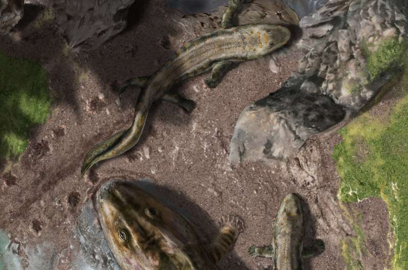
The aerial scene depicts two Late Devonian early tetrapods - Ichthyostega and Acanthostega - coming out of the water to move on land. Footprints trail behind the animals to show a sense of movement. Credit: Davide Bonadonna

One of the biggest questions in evolution is when and how major groups of animals first evolved. The rise of tetrapods (all limbed vertebrates) from their fish relatives marks one of the most important evolutionary events in the history of life. This "fish-to-tetrapod" transition took place somewhere between the Middle and Late Devonian (~400-360 million years ago) and represents the onset of a major environmental shift, when vertebrates first walked onto land. Yet, some of the most fundamental questions regarding the dynamics of this transition have remained unresolved for decades.

In a study published August 23 in Nature Ecology and Evolution Harvard researchers establish the origin date of the earliest tetrapods and discover they acquired several of the major new adaptive traits that enabled vertebrate life on land at accelerated evolutionary rates.

The study led by Dr. Tiago R. Simões, postdoctoral researcher, and senior author Professor Stephanie E. Pierce, both from the Department of Organismic and Evolutionary Biology, Harvard University, applied recently developed  (Bayesian evolutionary analysis) to precisely estimate the time and rates of anatomical  during the rise of tetrapods. The Bayesian method was adapted from methods originally developed in epidemiology to study how viruses like COVID-19 evolve and only recently became a tool in paleontology for the study of species evolution.

The study also innovates by combining data from  and body fossils to pinpoint the time of origin of the tetrapods. "Normally footprint data shows up after body fossils of their track makers. In this case, we have  footprints much older than the first body fossils by several million years, which is extremely unusual. By combining both footprint and body fossils, we could search for a more precise age for the rise of tetrapods," said Pierce.

"We were able to provide a very precise age for the origin of tetrapods at approximately 390 million years ago, 15 million years older than the oldest tetrapod body fossil," said Simões.

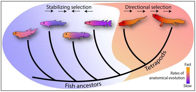
The researchers also found that most of the close relatives to tetrapods had exceptionally slow rates of anatomical evolution, suggesting the fish relatives to tetrapods were quite well adapted to their aquatic lifestyle.

"On the other hand, we discovered the evolutionary lineages leading to the first tetrapods broke away from that stable pattern, acquiring several of the major new adaptive traits at incredibly fast rates that were sustained for approximately 30 million years," said Simões.

Speedy Evolution
Animal silhouette colors represent rates of anatomical evolution for different body regions whereas background colors indicate groups undergoing stabilizing vs directional evolution towards new body plans. Credit: Tiago R. Simões and Stephanie E. Pierce

Simões and Pierce also extended molecular approaches to study how fast different parts of the early tetrapod body plan evolved—such as the skull, jaws, and limbs—and the strength of natural selection acting on each of them. They found that all parts of the tetrapod skeleton were under strong directional selection to evolve new adaptive features, but that the skull and jaws were evolving faster than the rest of the body, including the limbs

"This suggest that changes in the skull had a stronger role in the initial stages of the fish-to-tetrapod transition than changes in the rest of the skeleton. The evolution of limbs to life on land was important, but mostly at a later stage in tetrapod evolution, when they became more terrestrial," said Pierce.

"We see several anatomical innovations in their skull related to feeding and food procurement, enabling a transition from a fish-like suction-based mode of prey capture to tetrapod-like biting, and an increase in orbit size and location" said Simões. "These changes prepared tetrapods to look for food on land and to explore new food resources not available to their fish relatives."

The researchers also found that the fast rates of anatomical evolution in the tetrapod lineage were not associated with fast rates of species diversification. In fact, there were very few species around, so few they had a very low probability of being preserved in the fossil record.

This finding helps to answer an ongoing debate in evolution of whether new major animal groups originated under fast rates of anatomical change and species diversification (the classical hypothesis). Or, if there were high rates of anatomical evolution first, with increased rates of species diversification occurring only several million years later (a new hypothesis).

"What we've been finding in the last couple of years is that you have lots of anatomical changes during the construction of new animal body plans at short periods of geological time, generating high rates of anatomical evolution, like we're seeing with the first tetrapods. But in terms of number of species, they remained constrained and at really low numbers for a really long time, and only after tens of millions of years do they actually diversify and become higher in number of species. There's definitely a decoupling there," said Simões.

Pierce agreed, "It takes time to get a foothold in a new niche in order to take full advantage of it."

"Our study starts at the very beginning of this evolutionary story. There are many, many more chapters to come," said Pierce. "We want to next dig further in terms of what happened after the origin of tetrapods, when they started to colonize land and diversify into new niches. How does that impact their anatomical rates of evolution compared to their species diversification across the planet? This is just the very beginning. It's the introductory chapter to the book."

Water-to-land transition in early tetrapods

More information: Sustained high rates of morphological evolution during the rise of tetrapods, Nature Ecology and Evolution (2021). DOI: 10.1038/s41559-021-01532-x , www.nature.com/articles/s41559-021-01532-x

Journal information: Nature Ecology & Evolution 

Provided by Harvard University 


Volcanoes acted as a safety valve for Earth's long-term climate

Volcanoes acted as a safety valve for Earth’s long-term climate
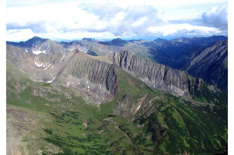
Continental volcanic arcs such as this one in Kamchatka, Russia, are rapidly weathered,
 driving CO2 removal from the atmosphere over geological time. 
Credit: Tom Gernon, University of Southampton

Scientists at the University of Southampton have discovered that extensive chains of volcanoes have been responsible for both emitting and then removing atmospheric carbon dioxide (CO2) over geological time. This stabilized temperatures at Earth's surface.

The researchers, working with colleagues at the University of Sydney, Australian National University (ANU), University of Ottawa and University of Leeds, explored the combined impact of processes in the solid Earth, oceans and atmosphere over the past 400 million years. Their findings are published in the journal Nature Geoscience.

Natural break-down and dissolution of rocks at Earth's surface is called chemical . It is critically important because the products of weathering (elements like calcium and magnesium) are flushed via rivers to the oceans, where they form minerals that lock up CO2. This feedback mechanism regulates atmospheric CO2 levels, and in turn , over .

"In this respect, weathering of the Earth's surface serves as a geological thermostat", says lead author Dr. Tom Gernon, Associate Professor in Earth Science at the University of Southampton, and a Fellow of the Turing Institute. "But the underlying controls have proven difficult to determine due to the complexity of the Earth system".

Volcanoes acted as a safety valve for Earth’s long-term climate
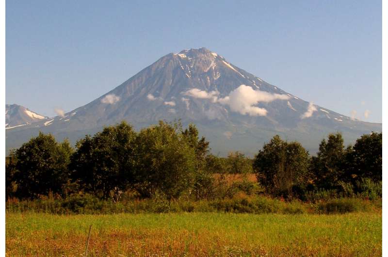
Present-day continental arc volcano in the Kamchatka Peninsula, Russian Far East. Credit: Tom Gernon, University of Southampton

"Many Earth processes are interlinked, and there are some major time lags between processes and their effects", explains Eelco Rohling, Professor in Ocean and Climate Change at ANU and co-author of the study. "Understanding the relative influence of specific processes within the Earth system response has therefore been an intractable problem".

To unravel the complexity, the team constructed a novel "Earth network", incorporating machine-learning algorithms and plate tectonic reconstructions. This enabled them to identify the dominant interactions within the Earth system, and how they evolved through time.

The team found that continental volcanic arcs were the most important driver of weathering intensity over the past 400 million years. Today, continental arcs comprise chains of volcanoes in, for example, the Andes in South America, and the Cascades in the US. These volcanoes are some of the highest and fastest eroding features on Earth. Because the  are fragmented and chemically reactive, they are rapidly weathered and flushed into the oceans.

Martin Palmer, Professor of Geochemistry at the University of Southampton and co-author of the study, said: "It's a balancing act. On one hand, these volcanoes pumped out large amounts of CO2 that increased atmospheric CO2 levels. On the other hand, these same volcanoes helped remove that carbon via rapid weathering reactions."

Volcanoes acted as a safety valve for Earth’s long-term climate
Global chemical weathering has been dominated by volcanic arcs over the past 400 million years (pictured: a river draining Bakening volcano, Kamchatka Peninsula, Russia). Credit: Tom Gernon, University of Southampton

The study casts doubt on a long-held concept that Earth's climate stability over tens to hundreds of millions of years reflects a balance between weathering of the seafloor and continental interiors. "The idea of such a geological tug of war between the landmasses and the seafloor as a dominant driver of Earth surface weathering is not supported by the data," Dr. Gernon states.

"Unfortunately, the results do not mean that nature will save us from climate change", stresses Dr. Gernon. "Today, atmospheric CO2 levels are higher than at any time in the past 3 million years, and human-driven emissions are about 150 times larger than volcanic CO2 emissions. The continental arcs that appear to have saved the planet in the deep past are simply not present at the scale needed to help counteract present-day CO2 emissions".

But the team's findings still provide critical insights into how society might manage the current climate crisis. Artificially enhanced rock weathering—where rocks are pulverized and spread across land to speed up chemical reaction rates—could play a key role in safely removing CO2 from the atmosphere. The team's findings suggest that such schemes may be deployed optimally by using calc-alkaline volcanic materials (those containing calcium, potassium and sodium), like those found in continental arc environments.

"This is by no means a silver bullet solution to the climate crisis—we urgently need to reduce CO2 emissions in line with IPCC mitigation pathways, full stop. Our assessment of weathering feedbacks over long timescales may help in designing and evaluating large-scale enhanced weathering schemes, which is just one of the steps needed to counteract global climate change", Dr. Gernon concludes.


Explore further

Earth's interior is swallowing up more carbon than thought

More information: Global chemical weathering dominated by continental arcs since the mid-Palaeozoic, Nature Geoscience (2021). DOI: 10.1038/s41561-021-00806-0 , www.nature.com/articles/s41561-021-00806-0
Journal information: Nature Geoscience 


Tree rings from old-growth Douglas firs on the Oregon Coast show evidence of 1700 tsunami

Tree rings from old growth Douglas-firs on the Oregon Coast show evidence of 1700 tsunami
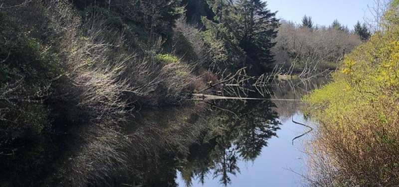
A stand of old growth Douglas-firs near a pond in Mike Miller Park in South Beach, Oregon. Credit: Bob Dziak

Core samples taken from a stand of old-growth Douglas fir trees in the South Beach area just south of Newport showed reduced growth following the 9.0 earthquake and subsequent tsunami that struck the Pacific Northwest in 1700.

The physical evidence from the Douglas fir tree rings confirms modeling that depicts the reach of the January 1700 quake, which was the last major earthquake to hit the Cascadia Subduction Zone, said Robert Dziak, a Hatfield Marine Science Center-based scientist with the National Oceanic and Atmospheric Administration Pacific Marine Environmental Laboratory.

"The tsunami appears to be the event that most affected the trees' growth that year," said Dziak, whose work includes ocean acoustic studies, signal analysis and tsunami modeling. He also holds a courtesy appointment in Oregon State University's College of Earth, Ocean, and Atmospheric Sciences. "Getting these little bits of the picture helps us understand what we might expect when the next 'big one' hits."

The findings were published recently in the journal Natural Hazards and Earth System Sciences.

The idea for the study dates back more than a decade; Dziak was aware of past research that had shown evidence of the 1700 quake in trees in Washington, and thought it might be worth seeing if similar evidence existed in Oregon.

The first challenge was finding a stand of old-growth Douglas firs in the tsunami inundation zone. The researchers looked at a few places before locating the stand in Mike Miller Park in South Beach, about two kilometers south of Yaquina Bay and 1.2 kilometers east of the present-day ocean shoreline.

"We're not sure why this tree stand wasn't logged over the years, but we're very fortunate to have a site so close to the coastline that has survived," said coauthor Bryan Black of the Laboratory of Tree-Ring Research at the University of Arizona, Tucson.

A new and updated tsunami model run by the researchers as part of the study shows that the area could have been inundated by up to 10 meters of water in the 1700 tsunami event, said Dziak.

Once the old-growth stand was identified, the researchers collected core samples from about 38 trees using a process that allows them to analyze the tree rings without damaging the overall health of the trees. The majority of the trees dated to around 1670, with one dating to 1650, Dziak said.

They analyzed the growth rates in the rings and compared the growth rates to those of other old-growth Douglas firs at sites not in the tsunami inundation zone. They found that in 1700 the trees in the tsunami inundation zone showed a significantly reduced growth rate.

Researchers are still working to figure out why the tsunami might have affected the trees' growth since the trees are relatively far from the shoreline. They suspect it may be a combination of the ground shaking from the earthquake and the inundation of .

"The salty seawater from a tsunami typically drains pretty quickly, but there is a pond area in Mike Miller Park where the seawater likely settled and remained for a longer period of time," Dziak said.

Black added that the researchers' next step is to conduct an isotopic analysis on the wood from 1700.

"We will look for signatures consistent with those found in  that were inundated by the 2011 Tohoku tsunami in Japan," he said. "If successful, we could develop a powerful new technique to map prehistoric tsunami run-up along the Pacific Northwest coast."Was Cascadia's 1700 earthquake part of a sequence of earthquakes?

More information: Robert P. Dziak et al, Assessing local impacts of the 1700 CE Cascadia earthquake and tsunami using tree-ring growth histories: a case study in South Beach, Oregon, USA, Natural Hazards and Earth System Sciences (2021). DOI: 10.5194/nhess-21-1971-2021

Provided by Oregon State University 

Tree rings from old growth Douglas-firs on the Oregon Coast show evidence of 1700 tsunami


Peer-Reviewed Publication

OREGON STATE UNIVERSITY

Old growth Douglas-firs 

IMAGE: A STAND OF OLD GROWTH DOUGLAS-FIRS NEAR A POND IN MIKE MILLER PARK IN SOUTH BEACH, OREGON. view more 

CREDIT: BOB DZIAK.

NEWPORT, Ore. – Core samples taken from a stand of old growth Douglas-fir trees in the South Beach area just south of Newport showed reduced growth following the 9.0 earthquake and subsequent tsunami that struck the Pacific Northwest in 1700.

The physical evidence from the Douglas-fir tree rings confirms modeling that depicts the reach of the January 1700 quake, which was the last major earthquake to hit the Cascadia Subduction Zone, said Robert Dziak, a Hatfield Marine Science Center-based scientist with the National Oceanic and Atmospheric Administration Pacific Marine Environmental Laboratory.

“The tsunami appears to be the event that most affected the trees’ growth that year,” said Dziak, whose work includes ocean acoustic studies, signal analysis and tsunami modeling. He also holds a courtesy appointment in Oregon State University’s College of Earth, Ocean, and Atmospheric Sciences. “Getting these little bits of the picture helps us understand what we might expect when the next ‘big one’ hits.”

The findings were published recently in the journal Natural Hazards and Earth System Sciences.

The idea for the study dates back more than a decade; Dziak was aware of past research that had shown evidence of the 1700 quake in trees in Washington, and thought it might be worth seeing if similar evidence existed in Oregon.

The first challenge was finding a stand of old growth Douglas-firs in the tsunami inundation zone. The researchers looked at a few places before locating the stand in Mike Miller Park in South Beach, about two kilometers south of Yaquina Bay and 1.2 kilometers east of the present-day ocean shoreline.

“We’re not sure why this tree stand wasn’t logged over the years, but we’re very fortunate to have a site so close to the coastline that has survived,” said coauthor Bryan Black of the Laboratory of Tree-Ring Research at the University of Arizona, Tucson.  

A new and updated tsunami model run by the researchers as part of the study shows that the area could have been inundated by up to 10 meters of water in the 1700 tsunami event, said Dziak.

Once the old growth stand was identified, the researchers collected core samples from about 38 trees using a process that allows them to analyze the tree rings without damaging the overall health of the trees. The majority of the trees dated to around 1670, with one dating to 1650, Dziak said.

They analyzed the growth rates in the rings and compared the growth rates to those of other old-growth Douglas-firs at sites not in the tsunami inundation zone. They found that in 1700 the trees in the tsunami inundation zone showed a significantly reduced growth rate.

Researchers are still working to figure out why the tsunami might have affected the trees’ growth since the trees are relatively far from the shoreline. They suspect it may be a combination of the ground shaking from the earthquake and the inundation of seawater.

“The salty seawater from a tsunami typically drains pretty quickly, but there is a pond area in Mike Miller Park where the seawater likely settled and remained for a longer period of time,” Dziak said.

Black added that the researchers’ next step is to conduct an isotopic analysis on the wood from 1700.

“We will look for signatures consistent with those found in trees that were inundated by the 2011 Tohoku tsunami in Japan,” he said. “If successful, we could develop a powerful new technique to map prehistoric tsunami run-up along the Pacific Northwest coast.”

Additional coauthors of the study are Yong Wei of the University of Washington Cooperative Institute for Climate, Ocean and Ecosystem Studies with NOAA/PMEL in Seattle; and Susan Merle of the Cooperative Institute for Marine Resource Studies at Hatfield Marine Science Center.

CAPTION

A stand of old growth Douglas-firs near a pond in Mark Miller Park in South Beach, Oregon.

CREDIT

Bob Dziak.


Norwegian company developing 1,000-foot-tall offshore wind turbine farms that could power 80,000 homes each

 
Aug 23, '21 
 
All images courtesy of Wind Catching Systems

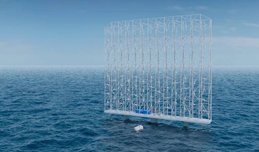
A Norwegian company is developing a new technology for floating, offshore wind turbine farms. Unlike traditional wind farms, these are organized in stacked, square grids, standing nearly as tall as the Eiffel Tower. 

The grids would stand at 1,000 feet tall, composed of multiple smaller turbines in a staggered formation atop a floating platform anchored to the ocean floor. Founded in 2017, Wind Catching Systems, in collaboration with Aibel AS as the main contractor and holding companies Ferd AS and North Energy ASA, aims to commercialize this wind catching technology. 

The company claims that its grids will increase efficiency, reduce land use by 80%, and reduce production costs, allowing the system to be immediately competitive with other traditional grid prices. In addition, the team states that one wind catching unit will be able to generate five times the annual energy output of the world’s largest single turbines and could produce enough electricity for 80,000 European households. This increased efficiency is attributed to the height of the grids, which exposes the rotors to higher wind speeds. Its smaller rotors can also perform better in higher wind speeds, whereas larger turbines tend to pitch their blades to avoid damage. 

Five Wind Catching units can produce the same amount of electricity as 25 conventional turbines, all while taking up much less space.

Furthermore, due to their array of small turbines, the grid system eliminates the need for a massive single component, which makes them easier to manufacture, install, and maintain. As reported by Asia Times, once the wind catching unit is deployed, the installation and maintenance work can be mainly conducted on-site without the need for specialist cranes or vessels. The wind turbine grids will have a design life of 50 years, compared to the 30-year lifespan of conventional wind turbines. 

“Our goal is to enable offshore wind operators and developers to produce electricity at a cost that competes with other energy sources, without subsidies,” says Wing Catching Systems CEO Ole Heggheim. “Simply put, we will deliver floating offshore wind at the costs of bottom-fixed technology solutions, which provides great opportunities on a global basis for the Norwegian supplier industry.”

The company aims to make its floating offshore wind technology competitive by 2023, which “is at least ten years earlier than conventional floating offshore wind farms.” 

Investment Director at Ferd, Erik Bjørstad, states that the goal is to complete technical testing and verification during 2021 and to offer commercial development solutions in 2022. 

“Wind Catching will challenge today’s established technology suppliers with its groundbreaking and patented design,” says Investment Director at North Energy Rachid Bendriss. “With our technology, offshore wind operators and developers will achieve the productions costs that they hoped to reach in 2030-2035 in a shorter timeframe.”