Thursday, December 30, 2021


Why this UK-based Oil and Gas Company is Diversifying its Portfolio with Canadian Assets

Jocelyn AspaJocelyn Aspa, The Market Herald
| November 30, 2021


Canada is undoubtedly one of the world’s largest producers of oil reserves and natural gas, producing on average 3.5 million barrels per day of crude oil and 13.7 billion cubic feet of natural gas.

Since early 2020, however, oil and gas production has suffered not only in Canada but around the world resulting from the COVID-19 pandemic. That being said, in 2021 and is projected to reach a valuation of $310.9 billion by 2035, resulting in growing investments in building Canada’s oil and gas infrastructure.

In line with this, it’s estimated that the production of crude oil in Canada is expected to outpace 2019 levels by the end of the year and continue its road to recovery in 2022.

To that end, companies like i3 Energy (TSX: ITE, LSE: I3E, Forum) are contributing to that growth thanks to its production base in Canada’s most prolific hydrocarbon region — the Western Canadian Sedimentary Basin — as well as appraisal assets in the North Sea.

With its primary headquarters in England, i3 Energy was first listed on the London Stock Exchange in 2017 and has been advancing its portfolio of assets in the United Kingdom since.

In the region, i3 Energy owns a 100 percent interest in Block 13/23c, which includes the Serenity oil field, discovered by i3 in late 2019, and the highly prospective Minos High region.

By late 2020, however, the company dipped its toes into the Canadian market by officially notching a listing on the Toronto Stock Exchange and acquiring Western Canadian Sedimentary Basin assets through a reverse takeover of privately-held Gain Energy and publicly-listed Toscana Energy Income Corporation.

With assets in both the United Kingdom and in Canada, i3 Energy presents itself as a unique oil and gas investment opportunity for investors looking for a company with a diverse portfolio in two well-established jurisdictions.

The Western Canadian Sedimentary Basin

Spanning 1.4 million square kilometres, the Western Canadian Sedimentary Basin (WCSB) is a vast sedimentary basin that spans southern Manitoba, southern Saskatchewan, Alberta, northeastern British Columbia, and the southwest corner of the Northwest Territories.

In a word, the region is considered a mature area for exploration of petroleum with more recent developments trending towards natural oil and gas sands instead of conventional oil — which includes light crude oil and heavy crude oil.

i3 Energy is firmly in control of its destiny in the WCSB with the company operating over 70% of its production across its ~800 (net) long-life, low-risk and low-decline wells, and having a sizeable land base of greater than 625,000 net acres.


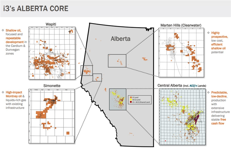
(Click to enlarge image)

The company currently has 2P reserves in the country of roughly 130 million barrels of oil equivalent and current production of over 18,000 boepd from large contiguous holdings in the WCSB’s most economic play types.

In an interview with Stockhouse Editorial Graham Heath, CFO of i3 Energy, said the company stands out in the Canadian market thanks to its access to capital in London — and its international focus — he said this has allowed i3 Energy to grow its business “very quickly.”

“A lot of our peers have taken 15 years to get to 20,000 boepd per day, and we’ve been able to do so in 18 months,” he said. “That continued access to capital will give us a strategic advantage to allow us to continue to not only grow organically but continue mergers and acquisitions as opportunities present themselves that fall within our metrics.”

Growing through M&A activity

Majid Shafiq, CEO of i3 Energy, explained to Stockhouse Editorial that part of i3 Energy’s business model is to grow through acquisitions, which it has been able to do thanks to several acquisitions — including the acquisition of all of the assets of Gain Energy in the WCSB.

The company said it is primarily targeting long-life and low-cost proved developed producing (PDP) assets with robust PUD inventories and a focus on distressed, overleveraged, or non-core asset packages of high API-BTU production streams with low-sustaining CAPEX and decom exposure.

In line with this, i3 Energy has been able to make moves and close acquisitions resulting from low oil prices and — in turn — start a drilling program once oil prices recovered.

This also led the company to acquire assets in central Alberta from Cenovus Energy Inc., a Canadian oil and gas producer, for C$65 million.

While oil and gas prices are “much higher” than they were several months ago, Shafiq said this won’t stop the company from continuing to expand its portfolio through M&A.

“We’re still seeing the opportunity to add accretive barrels via acquisition while we continue to grow production through the drill bit,” he told Stockhouse Editorial.

Posting record Q3 results

As part of the company’s continued growth, i3 Energy recorded impressive results during the third quarter, with average production of approximately 13,740 boepd based on net field sales estimates and September alone averaging approximately 18,985 boepd.

Since the company began acquiring Canadian assets in Q3 2020, i3 Energy has successfully implemented a strategy to offset natural field declines through operational attentiveness, the high-grading of low-cost drilling, reactivation, and recompletion opportunities, and through small-scale bolt-on acquisitions.

Heath told Stockhouse Editorial that highlights from the quarter “show the benefits of being bold at the bottom”. He said buying assets for 1.3x cash flow when oil is between $25 and $30 provides a greater margin of safety.

Essentially, Heath said all that needs to be done to turn a profit is for commodity prices to “do what they’ve done” to make those assets valuable. He added that the company is already seeing those benefits, with the company having produced £12.5 million (CAD$21 million) of net operating income (revenue minus royalties, opex, processing, and transportation) during H1 2021 while forecasting an additional £39 million (CAD$66 million) of net operating income during the second half.

Furthermore, Heath points out that they expect to produce almost CAD$150 million of net operating income from their WCSB assets during the coming 12 months – a figure that substantially surpasses what they have paid for their entire Canadian portfolio.

Future milestones

With 2021 ending soon, Shafiq said several key milestones are coming that investors should watch for, including the announcement of its planned 2022 capital budget for its Canadian assets.

In terms of the UK, Shafiq said that the company expects to further appraise its Serenity discovery in 2022, with its continued UK strategy focussed on the development of discoveries located close to existing infrastructure.

“We’re currently going through a farm-out process to bring in some capital and drill an appraisal well on Serenity, which will hopefully prove up the millions of barrels sitting in that field,” he told Stockhouse Editorial.

Additionally, the company has commenced a project with a consultancy to develop a comprehensive ESG strategy and expects to publish its first sustainability report in Q1 2022.

The management team

Majid Shafiq, CEO

Majid Shafiq has over 30 years of experience in technical and investment banking focused on the global E&P sector.

Before joining Argentil Capital Partners as CEO in 2015, Shafiq spent 12 years in energy investment banking with a focus on advising on asset level acquisitions and divestments and corporate M&A and equity financing for private and public companies in the oil and gas sector.

Additionally, Shafiq worked for Mobil Oil Corporation for 13 years in a range of petroleum engineering and commercial roles. Shafiq holds a bachelor’s degree in Nuclear Engineering from Manchester University, a master’s degree in petroleum engineering from Heriot-Watt University, and an MBA from London Business School.

Graham Heath, CFO

Before co-founding i3 in late 2014, Heath worked as VP of Corporate Development and also as interim CFO at Iona Energy.

At his time at Iona Energy, Heath worked with the senior management team, building the company from infancy to 40MMboe of 2P reserves and production above 6,000 boe per day and listing the company on the TSX Venture Exchange.

Between 1998 and 2010, Heath consulted Colt Engineering, Pan Canadian Petroleum, EnCana Corporation, and Cenovus Energy. Between 2002 and 2006, Heath was co-founder and VP of strategic development for The CO2 Hub, which is a marketplace to facilitate the sale and purchase of carbon dioxide and related purification, compression, storage, and transportation services.

Heath has a Bachelor of Commerce from the University of Calgary.

The investment corner

In short, the company presents itself as a unique opportunity to investors thanks to the unprecedented growth i3 Energy has undergone since making its acquisitions in Canada.

What’s more, i3 Energy implemented dividend payments during 2021, with Shafiq saying that the return of capital to investors is “absolutely fundamental to the company,” adding that i3 Energy will return capital to shareholders as it is generated.

Moving into the next year, Shafiq said investors will have plenty to keep their eyes on when it comes to i3 Energy as it looks to begin drilling and delivering good news from both Canada and the UK, which he said should translate to significant share price growth.

No doubt, i3 Energy is an exciting company to watch for — at a current share price of $0.18, investors won’t want to wait for good news to flow before diving in.

FULL DISCLOSURE: This is a paid article produced by Stockhouse Publishing.
Q&A: Cemvita Factory CEO on Whether Oil and Gas Industry Is Moving Swiftly Enough To Capitalize on Future of CCUS

Moji Karimi, CEO of Houston-based startup Cemvita Factory, talks about the status of oil and gas investments in the emergent technology arena of carbon capture, utilization, and sequestration.

December 2, 2021
By Trent Jacobs
Journal of Petroleum Technology

Is time running short for the upstream industry to move faster
 in its embrace of carbon capture and reuse projects?

Cemvita Factory is a Houston-based startup that has developed a suite of bioengineered microorganisms to convert carbon dioxide into chemical feedstocks. The company recently crossed a major milestone after announcing that its Series A investment round in October put its total cash raised to date over $10 million.

This latest fundraising was led by Energy Capital Ventures and 8090 Partners but also included the venture arms of Mitsubishi Heavy Industries and Occidental Petroleum (Oxy), the latter of which made its first equity investment in Cemvita Factory in 2019.

The company’s CEO and cofounder, Moji Karimi, holds degrees in drilling and petroleum engineering and previously worked with Weatherford International and for reservoir diagnostics firm Biota Technology. He has been an advocate for revamping the oil and gas industry's approach to innovation. In this Q&A, Karimi discusses the promising and not-so-promising developments he sees shaping the industry’s future in the CCUS sector.

What keeps you up at night as a former oil and gas professional who is now leading a CCUS startup?

I’m very happy that I’m doing something that I love, so what’s keeping me up at night is now mostly how to speed up our growth.

It wasn’t always like this though. When we started, it felt like I was the guy in that video where he is dancing by himself, and it takes a bit for people to join one by one but finally everyone is dancing. Right now, almost everyone is on the CCUS dance floor, which is exciting.

According to the International Energy Agency, to hold back global warming the world needs to reach a CCUS capacity of more than 7,600 megatons of CO2 per year compared to today’s total of a mere 40 megatons per year. So when we consider what realizing it ultimately requires, is there a risk that the vision of megascale CCUS is in a hype cycle?

I think there is a spectrum.

The different letters of CCUS are at different stages of market hype and technology development.

On one hand, you have CO2 sequestration and EOR which are fully de-risked, and on the other side you have direct air capture and CO2 utilization which are still being developed.

On that note, I also believe that CO2 storage is just a transitional solution until we figure out how to utilize and convert the CO2 into other valuable products. For that reason, at Cemvita we use the term “CCU$” instead. CO2 storage is a cost, but utilization is a new revenue source.

What’s the biggest factor holding back a more rapid approach to CCUS in the upstream oil and gas industry?

I think the main reason is that oil and gas executives have been reactive, and at best, not aggressive enough. In general, it seems the industry is still doing R&D with a business-as-usual mindset or as if energy transition is similar to a downturn, whereas in reality the industry is going through a massive transformation in the next decade or two.

Incremental improvements that we have relied on in the past won’t work for energy transition. We need radical solutions, and radical solutions call for radical leadership.

Some of the technologies that enable a sustainable energy mix in 2050 may not even be invented yet!

The upstream oil and gas industry has long taken a cautious approach to adopting new technologies due to the risks and capital at stake. Are there other heavy industries with similar challenges that you see as providing a template to move faster on R&D?

Tesla was founded in July of 2003 and SpaceX started in May of 2002. These two companies are less than 20 years old yet have transformed two massive industries with many established players.

That’s the type of innovation and execution that upstream oil and gas needs or we’ll be like the former Nokia CEO who said after being acquired by Microsoft, “We didn’t do anything wrong, but somehow, we lost.”

A tangible example is how the industry looks at the subsurface reservoir. Taking SpaceX as a model, the fundamental problem they solved was by making rockets reusable.

Can we make reservoirs reusable? The industry is pretty much doing no R&D on that.

Do you think the concept of lower-carbon oil and gas products—thanks to the offsetting effects of CCUS—will be warmly embraced by consumers and therefore encourage producers to go further despite the added cost CCUS brings?

No, the oil and gas industry had the opportunity to educate the public about the role that oil and gas play in the progress and prosperity that we all have enjoyed and unfortunately, we missed that window. So that led to the notion for keeping fossil fuels in the ground no matter the carbon footprint.

If you ask the average person on the street about methane, they think it’s a greenhouse gas worse than carbon dioxide and not as natural gas for power generation. The public doesn’t know about the interplay of molecules and electrons.

That said, the reality is that the world will continue to need fossil fuels and feedstocks for a long time and molecules with a lower carbon footprint will have an advantage. So, I’d say oil and gas companies don’t have much of a choice at this point not to invest in CCUS.

Whomever can figure out ways to produce the lowest- carbon hydrocarbons to be used either as fuels or feedstock will win.

If the upstream sector does not retain its role as the leader in CCUS, what other industry could take over?

CCUS is an industry sector in and of itself, but it does present an opportunity to the oil and gas industry for taking a leadership role.

That just makes logical sense, leveraging the existing talent and infrastructure in the oil and gas industry and having access to the CO2 sources. I’ve been saying that since 2018. Only a few companies have taken that leadership role with Oxy being in the forefront.

What about hydrogen production? Is this another potential business line, one some argue is verging on the hype cycle, and something that the upstream sector should not be chasing?

There is a lot of hype about hydrogen but again I think it’s all about the economical pathway that’s being considered for the interplay of molecules and electrons.

The downstream sector is already making hydrogen from methane and that can be coupled with CCUS to make blue hydrogen. Upstream sector plays a role for the storage of the CO2 captured from steam-methane reforming plants, but I don’t see it as a long-term value-add role in the hydrogen economy.

At our own company we are working on other pathways that enable the upstream sector to directly produce hydrogen.

Outside of your own developments, what specific energy transition or clean tech are you most excited about?

There are a few, I really like solutions that leverage the existing infrastructure in oil and gas but repurpose them in a sustainable way.

Geothermal, for example, you’ll still need geologists, drilling engineers, etc. Through our work at Cemvita, I also now think and cover a broader spectrum of energy transition technologies; for example I’m very interested in innovations in the mining sector to sustainably increase the recovery of key metals and minerals needed, then, of course, CCUS and downstream of CCUS for sustainable production of chemicals and polymers.


Trent Jacobs
Trent Jacobs has been a journalist and communications specialist for 15 years, most of which have been spent covering the upstream oil and gas industry. He reports from his hometown of Houston and highlights new trends from the SPE’s largest technical conferences in North America, Europe, Middle East, and Asia. Areas of special focus include emerging technologies, advancements in reservoir engineering, and the energy transition. He can be reached at tjacobs@spe.org


Eamon Ryan opens consultation on Ireland’s use of geothermal energy

Licensing system planned for exploration and capture of heat from below Earth’s crust

about 18 hours ago
Laura Slattery

Iceland’s Blue Lagoon: volcanic regions have long used accessible geothermal energy for industry and recreation. Photograph: Dukas/Universal Images via Getty

The Government has opened up a public consultation on the “exciting potential” of geothermal energy for heating and cooling buildings and for generating electricity.

Minister for the Environment, Climate and Communications Eamon Ryan on Tuesday published a draft policy statement on the use of such energy, which is heat from either the Earth’s core or the sun that is stored by rocks beneath the crust of the planet.

Mr Ryan said he wanted the statement to focus attention on the potential of geothermal energy and address “barriers” to its development in the Republic.
Statement

The statement describes geothermal projects as “expensive” and “subject to more initial uncertainty” than other forms of renewable energy, such as wind or solar power, because they involve drilling into the sub-surface to determine the available energy at specific locations.

It notes “an inherent risk” that any drilling exercise will not produce sufficient heat to make the project commercially viable.

The statement proposes that the Geoscience Regulation Office (GSRO) of the Department of the Environment, Climate and Communications will become the Geothermal Regulatory Authority. Any proposed geothermal project above a certain scale will require an exploration licence from the GSRO and later, if the resource is commercially exploited, a “capture lease”.

The department also intends to establish an advisory group, with members drawn from communities, environmental groups, regulatory agencies and those working on geothermal energy projects.

The overall aim is to “give certainty” about the ownership and use of geothermal energy, create a licensing process for its exploration and harnessing and establish a system of reporting on projects.

The Green Party leader said geothermal energy was “a secure, reliable, local, renewable source of energy” and that technological advances over the past decade meant it could play “a significant role” in the State’s transition to a carbon neutral and circular economy.

“Engagement with the public, community groups, industry and academia is critically important to developing our geothermal potential,” he said.

“I would encourage all interested parties to engage in this public consultation. It is an important step in addressing the barriers to the development of geothermal energy in Ireland. ”

Observations on the draft policy statement can be submitted by email to GSPD@decc.gov.ie until March 1st, 2022, with information sessions and other consultative events expected to take place in February.

Advances

While geothermal energy has long been used in volcanic regions such as in Iceland, Italy and New Zealand – where heat from beneath the earth’s crust is easily accessible – new technologies have seen it adopted in non-volcanic countries, including the Netherlands, Belgium, France, the UK and Germany.

Some of these technologies are already being used in the Republic, from small systems to single houses to larger systems used in industrial and retail buildings. But it is believed the more complex systems with higher output that are seen in other countries could help the State reach its climate goals if replicated here.

The department highlighted a need for greater data collection on the State’s geothermal resources as well as further research on the economics of geothermal energy projects. Although the temperature of the earth is estimated to rise 25 degrees for every kilometre beneath the surface of Ireland, the State’s geothermal potential is “not yet fully understood”.

A study by the Sustainable Energy Authority of Ireland found that up to 54 per cent of domestic, commercial and public sector demand for heating in Ireland could be met by district heating systems, with geothermal energy an important source of heat for this.

Geothermal energy can also be used for multiple industrial activities such as drying cement blocks, heating greenhouses, processing dairy products and brewing beer.


Recent Maryland earthquakes have been mild, but in 1886 one made some in Baltimore think their homes were haunted
By FREDERICK N. RASMUSSEN
BALTIMORE SUN |
AUG 26, 2021 AT 5:00 AM

Severe Maryland earthquakes are fairly rare, which ensures that they make headlines whenever one rumbles across the region.

A 2.6 magnitude earthquake rattled the area June 25, followed two days later by a 1.7 aftershock whose epicenter was near the Edmondson Village Shopping Center in West Baltimore, reported the U.S. Geological Survey.

Earlier this month, a 2.1 magnitude quake struck near Clarksville in Howard County. Its epicenter was Heritage Heights Park and could be felt as far north as Eldersburg and southward to Silver Spring.

No injuries or damage resulted from the earthquakes, which were deemed minor. According to the USGS, a 5.3 quake is considered moderate while a quake registering 6.3 on the Richter scale is classified as a strong one.

The Maryland Geological Survey classifies the mid-Atlantic and central Appalachian region as having a “moderate amount of low-level earthquake activity.”

The first reported quake in Maryland occurred April 25, 1758, striking south of Annapolis, but there are no records as to its strength, according to the Maryland Geological Survey. Experts estimate its magnitude was probably a 3.5 or 3.7. The strongest confirmed temblor was a 3.1 that rolled through Hancock in Western Maryland in 1978.

“What accounts for the earth’s rocking and rolling beneath Maryland at times can be blamed on the Marticville line, two rock strata that roughly parallel the Mason-Dixon Line,” The Sun reported in a 1986 article.

The earthquake that Baltimoreans would talk about for years wasn’t even from around here.

It was the great Charleston, South Carolina, earthquake of Aug. 31, 1886, that jangled nerves not only in Baltimore, but as far north as Boston, and westward to Chicago and Milwaukee, and as far south as New Orleans.

The jolts from that quake, estimated to be a magnitude of 7.0, were felt even in Cuba and Bermuda.

Starting at 9:50 p.m., the quake rumbled northward and by the time the shaking arrived in Baltimore at 10:05 p.m., it literally threw residents out of their beds and crashed dishes to the floor from cupboards, prompting the terrified to flee into the street thinking their houses were haunted, The Sun reported.

For an hour after the seismic event unfolded, phones rang wildly in the city room of the newspaper then located in the Sun Iron Building on East Baltimore Street, from the frightened and curious, seeking more particulars on what transpired.


Cracks from the August 2011 earthquake spread in the basement of the Baltimore Basilica, six years after a $40 million restoration of the oldest Catholic cathedral in the nation. A device monitors structural shifts. (Kim Hairston / Baltimore Sun)

“Coming as the shaking did at a time of the year when malaria is supposed to stalk about, it was suggested that, perhaps the earth was having its little malarial attack due to the sudden drop in the thermometer yesterday,” reported The Sun the next morning. “Whatever caused the shock there was a very perceptible tremor of the earth about five minutes past ten o’clock and continued about half a minute.”

At Guilford, which was the summer estate of A.S. Abell, founder of The Sun, the house rattled while the chandeliers swayed to and fro, reported an astonished Abell.

An Oak Street resident telephoned his North Charles Street pharmacy and “received the intelligence that the bottles in the establishment were dancing as if in high glee,” reported the newspaper.
[Most read] Feds criticized after acquittals in Ken Ravenell conspiracy trial; jury convicts on one count of money laundering »

A man living near the intersection of Broadway and Bank Street thought he was suffering an attack of vertigo as his desk moved from side to side while he was working. Another man sitting in his home was made “giddy” as his chair slid across the room while pictures on the wall bounced up and down from the vibration.

Young women dancing at 146 N. Charles St., stopped as soon as the floor began quivering beneath their feet, and on Barre Street, a Mrs. Buckey’s bed shook so violently that she thought a man was hiding underneath it, reported The Sun.

Frederick County farmers told the newspaper the quake shook for a duration of more than two minutes while reports came in from Cambridge that it had caused “nausea with a number of people who had been sleeping.”

For one Baltimorean, the quake proved to be a good thing. For years, a Mr. Thackermann had been bedeviled by two windows in his Eutaw Street office that he had been unable to close; they suddenly fell with a crash.

The captain of an inbound steamer, the Ewing, a revenue cutter approaching the bay, gave this account to The Sun of the quake’s strike.

“A strong gale came from the north. All at once there was a strange and weird appearance about everything. Nothing looked natural. In the heavens the stars were shooting in all directions, and the breaking seas were charged with phosphorus to such a pronounced degree that no one on board recollected ever seeing such a display,” he said.

While the quake killed 38 Charlestonians, wrecked telegraph lines and railroad tracks and cut the city off from the outside world, damage in Baltimore was mainly confined to broken crockery, glassware, and, in many cases, jangled nerves.


Frederick N. Rasmussen

I am one of The Sun's obituary reporters and have been writing them since the early 1990s. I attended Emerson College in Boston and wrote for Boston Magazine. I also was the author for nearly 20 years of The Sun's Back Story column.
Strange earthquakes in South Carolina traced to man-made lake

Lake Monticello in South Carolina has now caused three earthquake swarms.


Monticello reservoir in South Carolina at sunset.
 (Image credit: Zoonar GmbH / Alamy Stock Photo)

By Stephanie Pappas published November 05, 2021

A series of small earthquakes northwest of Columbia, South Carolina, are caused by a man-made lake built more than 40 years ago, according to geologists.

The tiny temblors — magnitude 2.0 and less — are jangling nerves near South Carolina's Lake Monticello, according to The State newspaper, but the tremors are not unprecedented. The reservoir set off a series of minor earthquakes when it was first filled in the late 1970s. Another small swarm occurred between 1996 and 1999. Since Oct. 25, there have been seven earthquakes detected near the lake, according to the South Carolina Department of Natural Resources.

These quakes are so small that someone standing on the surface might only notice them if they were right over the epicenter and there was no rumbling traffic nearby.
Sponsored Links

"We haven't had any large earthquakes at Monticello," said Pradeep Talwani, a professor emeritus of geology at the University of South Carolina who spent his career studying earthquakes caused by man-made lakes. Going all the way back to 1977, all of the quakes in the 

Reservoir-induced seismicity

What's happening at Lake Monticello is called "reservoir-induced seismicity." This phenomenon happens at relatively few reservoirs around the world, Talwani told Live Science. Regardless of location, the physics are always the same: A reservoir is built over rocks that contain fluid-filled fractures. When more water is loaded on top, it seeps into the fractures, causing the fluids to migrate and build up pressure. Ultimately, the pressure causes the rocks to slip and rattle the surrounding earth. This is the same reason that pumping fluids into oil wells for the purpose of fracking can cause earthquakes.

Mostly, these man-made earthquakes are small. Globally, only three reservoir-induced quakes with a magnitude of 6 or higher have ever occurred, Talwani said. (Earthquake damage can vary based on the local conditions and building materials, but magnitude 6 is typically the line at which serious damage occurs.) These damaging quakes occurred at deep reservoirs with more than 328 feet (100 meters) of water, Talwani said. In comparison, Lake Monticello is 89 feet (27 m) deep at its deepest.

"Compared to everything globally, Monticello is a little puddle," Talwani said.

Watching for quakes

It has been, however, a very well-monitored puddle. Researchers first learned about reservoir-induced seismicity in the 1960s in Denver, Colorado. Operators at a chemical weapons facility called the Rocky Mountain Arsenal drilled a deep well and began injecting waste fluid into what turned out to be highly fractured rock, triggering more than 700 earthquakes in five years, according to a 1966 article in the journal The Mountain Geologist.

Thus, scientists knew about the possibility of reservoirs triggering earthquakes by the time Monticello was constructed. Talwani and his team were already monitoring and studying small swarms at reservoirs such as Jocassee near the North Carolina-South Carolina border.


Lake Monticello was constructed in the 1970s as a water source for the nearby Virgil C. Summer Nuclear Power plant. Because scientists already knew that reservoirs could produce earthquakes, the Nuclear Regulatory Commission required careful monitoring of seismicity in the area. Talwani's research group conducted most of this monitoring, which gave them a stunningly detailed view of tiny earthquakes that wouldn't normally be picked up by U.S. Geological Survey equipment.


The lake has been the source of thousands of tiny quakes over the years, most far too subtle to be felt. The initial swarm of earthquakes after the reservoir filled wasn't surprising. But the quakes in the 1990s, 20 years after Lake Monticello was constructed, were a little more mysterious. Thanks to their detailed seismic monitoring, Talwani and his colleagues were able to figure out what had happened. Over time, they found, water from the lake had dissolved mineral "caps" that had been sealing off fractures in the rock. With these new fractures opened, water was able to move into them, again building up pressure and causing the rocks to slip.

RELATED CONTENT

Photo journal: The gorgeous San Andreas Fault

Gallery: This millennium's destructive earthquakes

Rainbow Basin: Photos of Yellowstone's colorful grand prismatic hot spring

Something similar is probably happening at Monticello now to cause the new earthquakes, Talwani said. However, it's impossible to say because the fine-grain seismic monitoring system is no longer in place. That means researchers can see only the largest quakes, not the miniscule ones that help them localize the origin of the seismicity.

"Now we have no idea what is going on, because we just have one [seismic] station in that area," Talwani said.

Researchers at the University of South Carolina may soon deploy more seismometers in the area, said Scott Howard, a state geologist at the South Carolina Department of Natural Resources. The quakes are likely to peter out or continue at the current levels of magnitude, Howard told Live Science.


Originally published on Live Science.

FRACKQUAKE

Latest quake in top U.S. oilfield to hike scrutiny of drilling waste injections


© Reuters/Angus Mordant

By Liz Hampton

(Reuters) - A magnitude 4.5 earthquake that rattled the Permian basin in Texas on Monday night is likely to add pressure on oil producers in the region to slow or stop underground wastewater injections that regulators believe may cause the tremors.

The quake, the third-largest to hit Texas this decade, occurred near Stanton and was the latest in a surge of temblors linked to the disposal of wastewater, a byproduct of oil and gas production. Wastewater injection can trigger quakes by changing pressures around fault lines.

It also comes shortly after the state Railroad Commission, which regulates its oil industry, halted the injection of water into deep wells in an area northwest of Midland amid the jump in seismicity.

The Commission on Tuesday said it had been in contact with disposal well operators in the affected area of the Permian and was sending inspectors to the facilities.

Monday's earthquake occurred in an area already under investigation by the Commission for increasing seismicity. A suspension of injections around its epicenter could impact some 18 active wells that dispose an average of 9,600 bpd each, according to water data and analytics firm B3 Insight.

The affected area "has a higher utilization of deep disposal - about 50% higher - than other areas in the Permian basin," said Kelly Bennett, CEO of B3.

Permian oil operators are already looking for ways to reduce wastewater injections after the oil regulator began imposing limits. Solutions include recycling the wastewater or trucking it elsewhere.

"If they're not able to do that, they may have no other choice but to shut these wells and choke production," said Thomas Jacob, vice president of oilfield services research for consultancy Rystad, adding that halting production was a last resort.

ConocoPhillips has 15 disposal wells in the region, where injections have been suspended, while rival Pioneer Natural Resources has eight, according to Rystad. Chevron and Coterra have both experienced a reduction of 400,000 bpd or more in disposal capacity as a result of the limits imposed by the Railroad Commission.

Texas regulators are closely watching other regions that have seen a jump in seismicity and could implement additional limits to saltwater disposal, particularly as quakes get stronger, analysts cautioned.

"It will put more pressure on the operators" to find other ways to handle water, said Fredrik Klaveness, CEO of NLB Water, which provides produced water treatment and recycling solutions for the oil industry.

(Reporting by Liz Hampton in Denver; Additional reporting by Marcy de Luna in Houston; Editing by Dan Grebler)
Earthquakes don’t kill people; buildings do. And those lovely decorative bits are the first to fall

News of Melbourne’s earthquake today made my left leg hurt. That’s the leg I nearly lost.

On February 22 2011, there were nine of us on a red bus from Sumner to Canterbury University in Christchurch. At 12.51, the unreinforced brick facade of 605 Colombo Street crushed our bus and four pedestrians. I felt brick after brick land on my left hip, and wondered how long I would last.

I’m the only one left — the lucky thirteenth.

I was taken to hospital on the back of a stranger’s truck. I broke more bones than the surgeons were willing to count, spent two months in hospital, and six months off work. More than a decade later, I feel the earthquake in every step.
Read news coverage based on evidence, not alarm.
Get newsletter

During that earthquake, 16 people were killed just on that one block of Christchurch’s main street. Melbourne and country Victoria are full of places just like it, with brick facades, parapets and gables.

It wasn’t the earthquake that killed everyone but me on that bus. It was the building, its lack of regulation, lack of structural support, and lack of a fence. It wasn’t just bad luck.
Emergency workers on Colombo Street in the aftermath of the 2011 earthquake. Mark Baker/AP

Changing New Zealand’s Building Act to prioritise “fally-offy bits” of buildings was not in my life plan. But extraordinary events can change ordinary life plans. So when I got out of hospital, I set my ordinary environmental work to the side, and took a couple years to brush up on seismology, earthquake engineering, and the seismic safety of buildings.

Five years later, the NZ Parliament ratified the “Brower amendment” to the Building Act to prioritise fixing unreinforced brick decorative bits of buildings. And now I’m asking Victoria to please learn from your Kiwi cousins.

Earthquakes don’t kill people; buildings do. And those lovely decorative bits of buildings are the first to fall, even in relatively mild earthquakes like the ones Victoria gets from time to time.

Read more: The earthquake that rattled Melbourne was among Australia's biggest in half a century, but rock records reveal far mightier ones

Building back better


After Christchurch, New Zealand learned our lesson and reformed our building legislation. Victoria can skip the truly painful part of the lesson — the deaths and injuries in the streets — and skip straight to the legislative reform.

The smart thing to do is create a separate category for non-structural unreinforced masonry: parapets (the small decorative extension at the top of a wall), gables and chimneys. This is a good idea because:
they are the cheapest to fix
they are the first to fall
they are the deadliest when they do.


A parapet is the decorative extension at the top of a wall, often found on top of buildings. Shutterstock

It makes sense to pick the low-hanging fruit first. It will greatly improve the safety of Victoria’s streets without costing an arm and a leg – literally or figuratively.

Here, the Canterbury Earthquakes Royal Commission recommended it. And GNS Science calls parapets, gables and chimneys “dangerous”, even in cities with low earthquake risk, such as Auckland, Dunedin and Melbourne.

Read more: 10 years since the Darfield earthquake rocked New Zealand: what have we learned?

The building that collapsed on our bus was expected to fall. Everyone knows unreinforced bricks fall. To me, the most predictable losses are the least acceptable. This is especially true when the methods of prevention are as known and straightforward as securing a parapet to the building’s structural core.

Fixing the parapets first has the highest ratio of safety gains to cost. There is no complicated inspection required. Parapets do not hold the building up.

Attaching them securely is less disruptive to the activity inside the building than replacing them entirely. That said, they could easily also be replaced with lighter, less deadly materials, as is often done in California.

Read more: Melbourne earthquake: what exactly happened, and what's the best way to stay safe from aftershocks?

The building that collapsed onto us was worth NZ$30,000 (A$29,000), according to its 2007 government valuation. The Royal Commission heard that attaching the front facade to the building would have cost NZ$200,000 (A$194,000).

By my calculations, saving my left leg cost taxpayers about half a million dollars.

Fixing parapets, gables and chimneys first is also equitable. Unreinforced masonry buildings pose a greater public danger to passers-by than other types of quake-prone buildings that risk collapsing inwards. Placarding the buildings will do nothing for those in the street and on the footpath.

Allowing the parapets to persist unattached benefits only the owner. The risks, meanwhile, are transferred to the public, and onto the public health system if an accident happens.

Fixing the most dangerous and least expensive bits first is also a cost-effective way to preserve heritage buildings. Fixing the fally-offiest bits might render unnecessary the full building strengthening, and might prompt owners to spend the money now rather than in several decades’ time when the entire building needs repairs.

I am not saying all buildings in Victoria or Melbourne should be whizz-bang “earthquake-proof” like those in Tokyo or San Francisco. I am recommending cheap, effective fixes to the bits of buildings that are easiest to fix, and deadliest if you don’t.

I treasure my left leg, scars and all. But please, Australia, learn from your Kiwi cousins.

This article is adapted, with permission, from a 2017 article that originally appeared in the journal Earthquake Spectra.

September 22, 2021

Author
Ann L Brower
Associate Professor of Environmental Science, University of Canterbury

Area of northwestern Quebec rumbled by magnitude 4.1 earthquake

Luca Caruso-Moro
CTVNewsMontreal.ca Digital Reporter
Tuesday, December 28, 2021 


A seismograph reading from the Institute of Ocean Sciences in Sidney on Monday is pictured: Dec. 23, 2019 (CTV News)

Some Quebecers felt the ground, windows and walls around them shake Tuesday night as a magnitude 4.1 earthquake rumbled an area near Val d'Or.

The quake took place about 40 kilometres northwest of the city, or nearly 600 kilometres northwest of Montreal.

It hit at around 6:22 pm and was located 10 kilometres below the surface of the earth, according to Earthquake Canada.


Magnitude 4.1 quakes are considered mild on the intensity scale. It remains unclear whether any significant damage was caused.


A magnitude 4.1 earthquake struck near Val D’Or Tuesday evening. (Image source: Earthquakes Canada)

At the local depanneur in the town of Malartic, the wine bottles on the shelves began to shake, the cashier on duty told CTV News.

"The bottles on the shelves were shaking," she said. "It was pretty strange. I’ve never seen that before."

Many other locals also reported online that they felt the shaking. Some, in the mining-heavy region, first believed they were feeling the effects of blasting at a nearby mine.


ICELAND 

Fagradalsfjall volcano update: more and


more frequent earthquakes reflect magma


intrusion


Wed, 29 Dec 2021, 04:30
04:30 AM | BY: MARTIN
The seismic activity during 21-28 Dec on the Reykjanes peninsula (image: IMO)
600 quakes have been detected since midnight, but have occurred at a lower number than yesterday at the same time.
A maximum magnitude of 3.6 occurred yesterday at 08:25 local time.
Magma migration at depth is still about to pressurize and the increase in the seismic activity is likely a sign of its accumulation.
19000 earthquakes have already been detected in total, mostly with magnitudes of 4 or more since the seismic crisis started on 21 December.
Tue, 28 Dec 2021, 00:28
The seismic activity during 21-26 Dec on the Reykjanes peninsula (image: IMO)
The number of earthquakes rapidly increasing but the activity slowed down a bit over the past 24 hours. ... Read all
Fri, 24 Dec 2021, 02:10
Ground deformation measured during 16-22 Dec in the area of Fagradalsfjall (image: IMO)
The elevated seismic activity continues. ... Read all
Thu, 23 Dec 2021, 01:38
Distribution of earthquakes over the past 24 hours (image: IMO)
The Icelandic Meteorological Office (IMO) detected an increasing trend of seismic activity began yesterday. ... Read all


How Fault Surface Features Can Tell Us About Future Earthquakes

A new study suggests ways to quantify fault maturity, a property that affects earthquake characteristics.
21 December 2021
The San Andreas Fault, a mature strike-slip fault, is well studied because it lies near major population centers. Understanding fault maturity here and at other faults can help scientists model earthquakes and assess risks to nearby communities. Credit: Doc SearlsCC BY-SA 2.0

Source: Geophysical Research Letters

Earthquakes cannot be forecast like weather, but fault line characteristics, such as structural maturity, can give hints about how a future earthquake may act. Structural maturity is related to the age of the fault, but especially important is its “experience,” how much a fault has developed and changed over time and activity.

Mature and immature faults generate very different earthquakes. Mature faults release less stress, but their rupture propagates quickly down their length, whereas immature faults create high-energy, slower quakes. A quick assessment of a fault’s maturity will help scientists better understand the risks they pose to nearby communities.

A new study seeks to quantify faults’ maturity into a useful metric to help assess earthquake risks. Manighetti et al. measured surface features of fault lines that previous studies had evaluated at several maturity levels. They then analyzed their measurements to see how they related to the maturity judgment.

The researchers found that corrugation (i.e., undulation) and step-overs were good maturity indicators. Immature faults were reliably shorter, with high corrugation and high step-over density. As faults matured, they lengthened and smoothed out, reducing undulations and step-over density.

These traits are not only reliable across faults; they are also detectable at low resolutions. Scientists can map as little as a third of a fault’s length at relatively low resolution and still generate an accurate assessment of a fault’s maturity. This means that these metrics are practical for models and hazard assessments. Applying neural networks to the mapping process would make this method even easier, according to the authors. (Geophysical Research Letters, https://doi.org/10.1029/2021GL095372, 2021)

—Elizabeth Thompson, Science Writer

Citation: Thompson, E. (2021), How fault surface features can tell us about future earthquakes, Eos, 102, https://doi.org/10.1029/2021EO210677. Published on 21 December 2021.

Text © 2021. The authors. CC BY-NC-ND 3.0


Nearly 300 Years Ago, a Tsunami Hit The Coast of Chile, But Nobody Found It Until Now


The 1960 Chilean tsunami caused disaster in Japan. (NWS/Public Domain)

CARLY CASSELLA
13 DECEMBER 2021

The south-central coast of Chile could be more vulnerable to tsunamis than the historical record suggests.

Geological research among the tidal marshes of Chaihuín has now revealed the fallout of a long, high wall of water that struck land in 1737. Written documents from the time, however, describe no such wave.


"There are records of an earthquake in the area in 1737, but there is nothing in these records to indicate it generated a tsunami," says Emma Hocking from Northumbria University in the United Kingdom.

That's a problem, because it suggests our future tsunami predictions are based on a miscalculation. Instead of recurring once every 280 years, earthquakes that have the potential to produce tsunamis may arrive as frequently as once every 130 years.

The discovery is based on the sediment layers found in a tidal marsh near Valdivia, a historic city on the south coast of Chile that was hit by a massive, magnitude 9.5 earthquake in 1960.

This ground-breaking event ultimately triggered a deadly tsunami that hit the Chilean coast at a height of about 25 meters, while also battering the coasts of Japan, the Philippines, New Zealand and Hawaii.

Written records suggest earthquakes near Valdivia were followed by tsunamis in 1837 and 1575, but for some reason, the earthquake in 1737 lacked a corresponding wave.

In the past, researchers have explained away this missing tsunami by suggesting that the 1737 earthquake was caused by a deep rupture between two tectonic plates underneath the land, as opposed to under the sea.

But when researchers analyzed the sediment and single-celled algae found in Chaihuín, they found evidence of tsunami inundation on land.

Aerial view of the Chaihuín tidal marsh. (Northumbria University)

"By combining deformation and tsunami modelling, we show that our evidence of coastal subsidence and tsunami inundation at Chaihuín is better explained by offshore, shallow megathrust slip rather than by deeper slip below land as previously suggested," the authors write.

The most likely depth of the earthquake that caused this tsunami would be around 20 kilometers (12 miles) or less. After all, a shallower earthquake that hits offshore is more likely to produce a tsunami in its wake.

At Chaihuín, the authors found three distinct sand sheet layers, deposited by locally sourced tsunamis.

The layer A deposits coincide with the 1960 earthquake and tsunami, while the sands of B and C represent tsunamis derived from the 1737 and 1575 earthquakes, respectively.

Although there were other earthquakes that hit during the time that layer B was deposited, the 1737 earthquake was the closest to this salt marsh. Other geological research elsewhere along the coast has not turned up similar deposits, which suggests the tsunami from the 1737 earthquake hit a smaller region than the 1960 tsunami.


The same fault lines, therefore, appear capable of producing slightly different natural disasters over time - something we need to be acutely aware of in the future.

"Tsunami hazard assessment is often based on historic records of flooding along particular coastlines, with the frequency of past tsunami occurrence used to predict the potential future risk," explains Hocking.

"However, such records are sometimes incomplete because reporting of tsunamis can be greatly affected by societal unrest or other crises. In this case, it is believed that the lack of chronicles of a tsunami could be attributed to uprisings that had driven settlers from most of the colonial outposts in the area."

As a result, researchers are calling for caution when it comes to using historical records to predict future earthquakes and tsunamis.

To give ourselves a better idea of what could happen in the future and when, we need to compare historical records to direct geological evidence.

The new findings only come from one region of the Chilean coast, about 20 kilometers south of Valdivia, so further research will be needed in other nearby areas to truly understand the scope and timing of the 1737 tsunami.

The study was published in Communications Earth & Environment.
FEATURE: Divestment, not reform, to dominate Nigeria's oil sector in 2022


HIGHLIGHTS

Time running out for Nigeria's upstream: analysts

Implementation of Petroleum Industry Act critical

Pumping barely close to two-thirds of total capacity


Author
Eklavya Gupte with Staff Reports
Editor
Jim Levesque
Commodity
Energy Transition, Natural Gas, Oil

2022 poses to be a very challenging year for Nigeria. Africa's largest oil producer faces a race against time to implement reforms needed to bolster exploration and check declining oil production as it fights a wave of divestments from international oil companies.

The signing into law of the long-delayed energy legislation called the Petroleum Industry Act, previously known as the Petroleum Industry Bill, in August this year is not expected to bring the much-needed succor to the oil sector. Rather, Nigeria is likely to contend with a gale of divestments by major oil companies to reduce operating, security challenges and the huge costs of battling with the pandemic, industry officials and analysts told S&P Global Platts.

The landmark PIA was signed into law Aug. 16 and was expected to turn the state oil company Nigerian National Petroleum Corp. to a private company within six months in order to make it easier for the struggling company to raise funds for oil exploration and production. But impact of this bill has so far been barely felt.

Divestment dilemma

The PIA could be hugely beneficial, but government officials have lacked professionalism in putting it into place, Abiodun Adesanya, the CEO of Lagos-based oil consultancy Degeconek, told S&P Global Platts.

"The fact is that this Petroleum Industry Act is coming a little too late as it has been delayed for too long," Adesanya said. "Those who were rightly placed to pioneer the implementation are not the people in government now."

"So, I expect to see more divestment by oil majors from selected assets because things are not working as they should be."

Many oil majors are starting to divest legacy oil and gas assets in Africa as they target net-zero carbon emissions while hanging onto their most efficient and often largest oil projects.

Nigeria could be the worst hit as Shell, Chevron, and ExxonMobil are close to selling their onshore assets in the West African country.

Nigeria is under pressure to implement the PIA as soon as possible, according to Mike Sangster, managing director of TotalEnergies in Nigeria.

"The window for investments into fossil fuels is narrowing," he said at a recent industry event. "Very few years would remain for access to urgent funds to develop the Nigerian petroleum industry."


Production setbacks


This all comes at a time when Nigerian is struggling to produce at even two-thirds of its total capabilities.

Nigeria has the capacity to pump around 2.2 million b/d of crude and condensate, but in 2021 output has been languishing near 1.55 million b/d due to a slew of operational and technical issues.

The Nigerian government is aiming to attract much-needed investment to bolster oil exploration and production and increase reserves and output to 40 billion barrels and 3 million b/d, respectively, by the mid-2020s, but these targets are starting to look unattainable.

The pandemic and the acceleration of the energy transition away from fossils fuels does not bode well for Nigeria, which is desperate to kickstart its exploration and production programs.

Projects like Shell's Bonga Southwest/Aparo, TotalEnergies' Preowei and Exxon's Bosi are all at risk of never being developed. These fields have the potential to add a total of around 400,000 b/d to Nigerian oil production.

"Investment decisions are billed to be taken on these landmark projects around next year to arrest Nigeria's sagging oil production volumes," an official from the Nigerian Upstream Petroleum Regulatory Commission told S&P Global Platts. "But there are dark clouds hovering around sanctioning these projects now due to the emergence of the new COVID-19 variant."

Ongoing field and pipeline issues, fiscal stress and insecurity in the Niger Delta are likely to continue to threaten the growth outlook for Nigerian oil output, according to S&P Global Platts Analytics.

Bonny Light, Escravos and Forcados have all faced production issues in 2021, while the output of other key grades, such as Qua Iboe, Brass River, Agbami, Akpo, and Egina, has also remained consistently low this year.

Nigerian oil supply will grow to 1.7 million b/d by April 2022, down from levels of 1.9 million b/d in April 2020, Platts Analytics said in its recent forecast.

Gasoline subsidies


How Nigeria's government will navigate its policy of ending gasoline subsidies from July 2022 remains another stern test for the African oil producer.

Nigeria imports almost all the gasoline it consumes locally, estimated at 1.25 million mt/month, due to the poor performance of the four state-owned refineries. The government's subsidy is the difference between the landing cost of gasoline and the regulated pump price.

The removal of these costly subsidies is domestically viewed as unpopular and politically sensitive, with opposition parties and labor groups urging the government to reverse decision.

The Nigerian Labor Congress, the umbrella body for Nigerian workers, has said it will reject the government's bid to increase fuel prices. "The impact of price hike will be would affect be felt by all Nigerians, motorists, households, transporters, who are already contending with stagnated wages."