Wednesday, March 30, 2022


Stunning Subsurface Images of Yellowstone National Park Reveal “Mystery Sandwich” Plumbing System
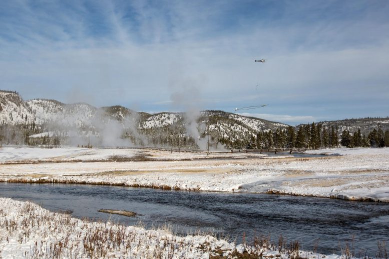
SkyTEM Instrument Flown Over Old Faithful

The SkyTEM instrument being flown over Old Faithful in Yellowstone National Park. Credit: Photo by Jeff Hungerford, Yellowstone National Park; supplied by Carol Finn of U.S. Geological Survey

The geysers and fumaroles of Yellowstone National Park are among the most iconic and popular geological features on our planet. Each year, millions of visitors travel to the park to marvel at the towering eruptions of Old Faithful, the bubbling mud cauldrons of Artists Paint Pots, the crystal-clear water, and iridescent colors of Grand Prismatic Spring, and the stacked travertine terraces of Mammoth Hot Springs.

Those who have visited the park may have asked themselves, “Where does all the hot water come from?” A study published last week in Nature, co-authored by Virginia Tech’s W. Steven Holbrook and colleagues from the U.S. Geological Survey and Aarhus University in Denmark, provides stunning subsurface images that begin to answer that question.

The research team used geophysical data collected from a helicopter to create images of Yellowstone’s subsurface “plumbing” system. The method detects features with unusual electrical and magnetic properties indicative of hydrothermal alteration.

“The combination of high electrical conductivity and low magnetization is like a fingerprint of hydrothermal activity that shows up very clearly in the data,” said Holbrook, a professor of geophysics and head of the Department of Geosciences in Virginia Tech’s College of Science. “The method is essentially a hydrothermal pathway detector.”

Images from the study show that the park’s geology profoundly shapes its hot springs. Hot hydrothermal fluids ascend nearly vertically, from depths of more than 1 km (or .62 miles), to arrive at the park’s major hydrothermal fields. Along the way, they mix with shallower groundwater flowing within and beneath the park’s volcanic lava flows, which also are visible in the images. Faults and fractures guide the ascent of hydrothermal waters, while lava flow boundaries control the shallow groundwater aquifers.
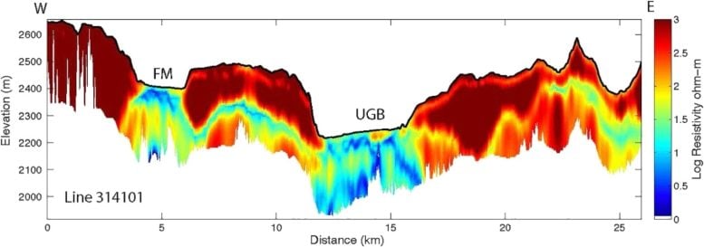
Subsurface Image of Yellowstone Hydrothermal Features

An example of a subsurface image of Yellowstone hydrothermal features produced from SkyTEM data. Blue colors are electrically conductive hydrothermal pathways; red features are electrically resistive lava flows. This line crosses two hydrothermal areas, one in the center of the figure that is near Old Faithful, and one labeled “FM” for Firehole Meadows. Credit: W. Steven Holbrook / Virginia Tech

The project fills in a longstanding knowledge gap about the underpinnings of Yellowstone’s charismatic hydrothermal features. Much is known about the park’s surface hydrothermal features, including the chemistry and temperature of mud pots and springs, the eruption interval of geysers, and the unique thermophilic bacteria that live in and around those features.

Likewise, scientists have a growing body of knowledge about the deeper heat sources and tectonic activity by tracking earthquakes that occur there. But little is known about how the surface hydrothermal features are connected to each other and to the deeper sources of heat and fluids.

“Our knowledge of Yellowstone has long had a subsurface gap,” Holbook said. “It’s like a ‘mystery sandwich’ — we know a lot about the surface features from direct observation and a fair amount about the magmatic and tectonic system several kilometers down from geophysical work, but we don’t really know what’s in the middle. This project has enabled us to fill in those gaps for the first time.”

To collect the data, the team used a unique instrument called “SkyTEM” that consists of a large loop of wire towed beneath a helicopter. As the helicopter flies, the loop sends downward repeated electromagnetic signals that provoke a response from electrically conductive bodies in the subsurface.

That response is recorded and later analyzed to produce detailed cross-sections along the flight lines. The technique is highly effective in environments like Yellowstone: hydrothermal fluids alter the rocks they pass through, turning rock into clay minerals — for example, the surface mud pots — that have heightened electrical conductivity but suppressed magnetization.

Steve Holbrook

Steve Holbrook, professor and head of the Department of Geosciences. Credit: Mike Lee for Virginia Tech

Because the helicopter is able to travel at speeds of 40 to 50 mph while towing the SkyTEM instrument, scientists involved in the study were able to cover large swaths of the sprawling, 3,500-square-mile national park, Holbrook said.

“One of the unique aspects of this dataset is its extensive coverage of this huge system,” Holbrook added. “We were able not just to look deep beneath the hydrothermal features, but also to see how adjacent features might be connected in the subsurface across great distances. That’s never been possible before.”

One of the mysteries addressed by the new work is whether different hydrothermal areas in the park show contrasting deep fluid sources and pathways. The team found a remarkable similarity in the deep structure beneath areas such as Norris Geyser Basin and Lower Geyser Basin, suggesting that contrasts in the chemistry and temperatures of those areas are not caused by deep processes. Instead, variable degrees of mixing with shallow groundwater likely create the wide variety of hot spring characteristics in the park.

Overall, the project generated more than 2,500 miles of helicopter lines, an enormous amount of data, according to Holbrook. Upon the study’s publication last month, the research team released the data so that others can undertake additional research.

“The data set is so big that we’ve only scratched the surface with this first paper,” Holbrook added. “I look forward to continuing to work on this data and to seeing what others come up with, too. It’s going to be a data set that keeps on giving.”

Before coming to Virginia Tech in 2017, Holbrook was part of the Department of Geology and Geophysics at the University of Wyoming in Laramie, Wyoming. He also co-directed the Wyoming Center for Environmental Hydrology and Geophysics. He said, “I’ve made several field trips to collect ground-based geophysical data in Yellowstone. The airborne data covers a lot more ground much more quickly than we could by hiking gear into the backcountry, though.”

Carol Finn of the U.S. Geological Survey and lead author on the study said, “While the airborne data were still being collected, we saw the first images over Old Faithful and knew instantly that our experiment had worked — that we could, for the first time, image the fluid pathways that had long been speculated.”

She added, “Our work has sparked considerable interest across a range of disciplines, including biologists looking to link areas of groundwater and gas mixing to regions of extreme microbiological diversity, geologists wanting to estimate volumes of lava flows, and hydrologists interested in modeling flow paths of groundwater and thermal fluid. With the paper as a guide and the release of the data and models, we will enable research in these diverse scientific communities.”

One mystery that Holbrook is interested in pursuing further is evidence for distant connections between isolated surface hydrothermal areas. The SkyTEM data show evidence for subsurface linkages between hydrothermal systems that are up to 6 miles apart.

“That might have implications for the co-evolution of thermophilic bacteria and Archaea,” Holbrook said. “The notion that airborne geophysical data could illuminate something about the life of microscopic organisms living around hot springs is a fascinating idea.”

Reference: “Geophysical imaging of the Yellowstone hydrothermal plumbing system” by Carol A. Finn, Paul A. Bedrosian, W. Steven Holbrook, Esben Auken, Benjamin R. Bloss and Jade Crosbie, 23 March 2022, Nature.
DOI: 10.1038/s41586-021-04379-1
We recommend

Smoke from Australia’s intense fires in 2019 and 2020 damaged the ozone layer

Increasingly large blazes threaten to undo decades of work to help Earth’s protective layer


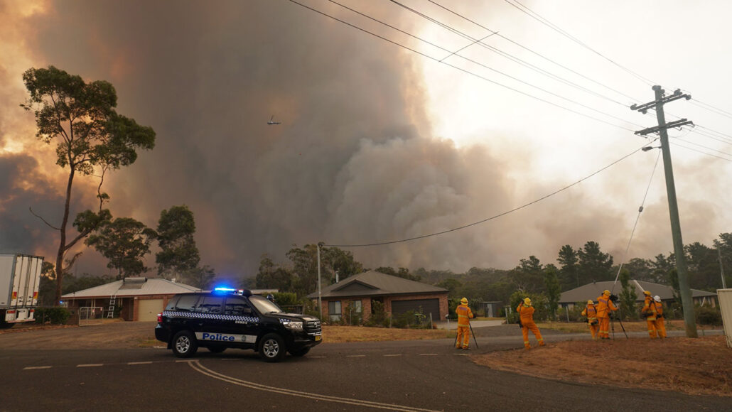
A towering cloud of smoke rises over the Green Wattle Creek bushfire
 on December 21, 2019, near the township of Yanderra in New South Wales, Australia.

By Carolyn Gramling
MARCH 17, 2022 

Towers of smoke that rose high into the stratosphere during Australia’s “black summer” fires in 2019 and 2020 destroyed some of Earth’s protective ozone layer, researchers report in the March 18 Science.

Chemist Peter Bernath of Old Dominion University in Norfolk, Va., and his colleagues analyzed data collected in the lower stratosphere during 2020 by a satellite instrument called the Atmospheric Chemistry Experiment. It measures how different particles in the atmosphere absorb light at different wavelengths. Such absorption patterns are like fingerprints, identifying what molecules are present in the particles.

The team’s analyses revealed that the particles of smoke, shot into the stratosphere by fire-fueled thunderstorms called pyrocumulonimbus clouds, contained a variety of mischief-making organic molecules (SN: 12/15/20). The molecules, the team reports, kicked off a series of chemical reactions that altered the balances of gases in Earth’s stratosphere to a degree never before observed in 15 years of satellite measurements. That shuffle included boosting levels of chlorine-containing molecules that ultimately ate away at the ozone.

Ozone concentrations in the stratosphere initially increased from January to March 2020, due to similar chemical reactions — sometimes with the contribution of wildfire smoke — that produce ozone pollution at ground level (SN: 12/8/21). But from April to December 2020, the ozone levels not only fell, but sank below the average ozone concentration from 2005 to 2019.

Earth’s ozone layer shields the planet from much of the sun’s ultraviolet radiation. Once depleted by human emissions of chlorofluorocarbons and other ozone-damaging substances, the layer has been showing signs of recovery thanks to the Montreal Protocol, an international agreement to reduce the atmospheric concentrations of those substances (SN: 2/10/21).

But the increasing frequency of large wildfires due to climate change — and their ozone-destroying potential — could become a setback for that rare climate success story, the researchers say (SN: 3/4/20).

Questions or comments on this article? E-mail us at feedback@sciencenews.org

CITATIONS

P. Bernath, C. Boone and J. Crouse. Wildfire smoke destroys stratospheric ozone. Science. Vol. 375, March 18, 2022, p. 1,292. doi: 10.1126/science.abm5611.


About Carolyn Gramling
E-mail
Twitter
Carolyn Gramling is the earth & climate writer. She has bachelor’s degrees in geology and European history and a Ph.D. in marine geochemistry from MIT and the Woods Hole Oceanographic Institution.

Palpable Change in Fire Dynamics Confirmed: U.S. Wildfires 4x Larger, 3x More Frequent Since 2000

Alder Fire in Yellowstone National Park

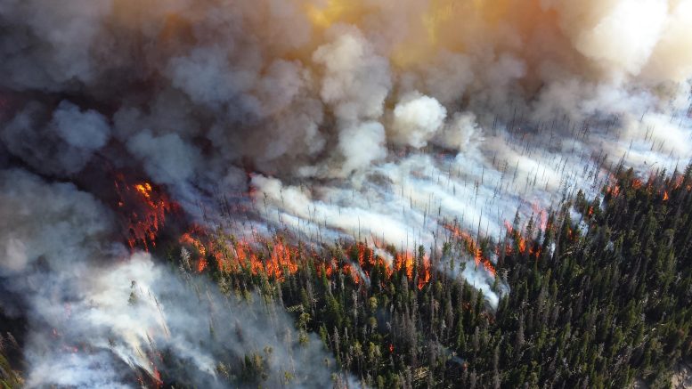
This is a 2013 photo of the Alder Fire in Yellowstone National Park. Credit: Mike Lewelling, National Park Service

New analysis confirms a palpable change in fire dynamics already suspected by many.

Fires have gotten larger, more frequent, and more widespread across the United States since 2000, according to a new CIRES Earth Lab-led paper. Recent wildfires have stoked concern that climate change is causing more extreme events, and the work published recently in Science Advances shows that large fires have not only become more common, they are also spreading into new areas, impacting land that previously did not burn.

“Projected changes in climate, fuel, and ignitions suggest that we’ll see more and larger fires in the future. Our analyses show that those changes are already happening,” said Virginia Iglesias, a research scientist with CIRES’ Earth Lab and lead author of the paper.

To evaluate how the size, frequency, and extent of fires have changed in the United States, Iglesias and her colleagues analyzed data from over 28,000 fires that occurred between 1984 and 2018 from the Monitoring Trends in Burn Severity (MTBS) dataset, which combines satellite imagery with the best available state and federal fire history records.

DC 10 Drops Fire Retardant 2020 Calwood Fire

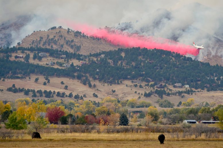
A DC-10 drops fire retardant on the edge of the 2020 Calwood Fire in Colorado. Credit: William Travis, University of Colorado

The team found that there were more fires across all regions in the contiguous United States from 2005 to 2018 compared to the previous two decades. In the West and East, fire frequency doubled, and in the Great Plains, fire frequency quadrupled. As a result, the amount of land burned each year increased from a median of 1,552 to 5,502 square miles (4,019 to 14,249 km2) in the West and from 465 to 1,295 square miles (1,204 to 3,354 km2) in the Great Plains.

The researchers also took a closer look at the most extreme fire events in each region. They found that in the West and Great Plains, the largest wildfires grew bigger and ignited more often in the 2000s. Throughout the record, large fires were more likely to occur around the same time as other large fires.

“More and larger co-occurring fires are already altering vegetation composition and structure, snowpack and water supply to our communities,” Iglesias explained. “This trend is challenging fire-suppression efforts and threatening the lives, health, and homes of millions of Americans.”

Finally, the team discovered that the size of fire-prone areas increased in all regions of the contiguous United States in the 2000s, meaning that not only is the distance between individual fires getting smaller than it was in the previous decades, but also that fires are spreading into areas that did not burn in the past. 

These results confirm a palpable change in fire dynamics that has been suspected by the media, public, and fire-fighting officials. Unfortunately, the results also align with other troubling risk trends, such as the fact that development of natural hazard zones is also increasing wildfire risk. “These convergent trends, more large fires plus intensifying development, mean that the worst fire disasters are still to come,” said co-author and Earth Lab deputy director, William Travis.

The study authors suggest that to adapt and build resilience to wildfire impacts, planners and stakeholders must account for how fire is changing and how it is impacting vulnerable ecosystems and communities.

Reference: “U.S. fires became larger, more frequent, and more widespread in the 2000s” by Virginia Iglesias, Jennifer K. Balch and William R. Travis, 16 March 2022, Science Advances.
DOI: 10.1126/sciadv.abc0020

We recommend


Tonga Volcano Eruption Caused Massive Space Plasma Disturbances on a Global Scale

Hunga Tonga Erupts

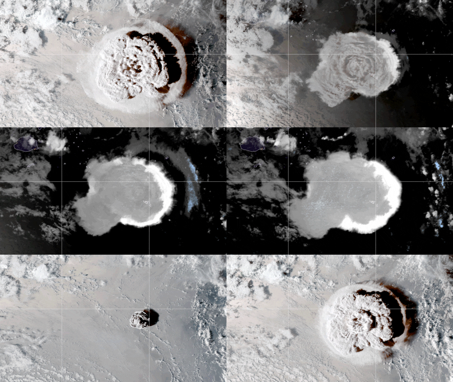
This looping video shows a series of GOES-17 satellite images that caught an umbrella cloud generated by the underwater eruption of the Hunga Tonga-Hunga Ha’apai volcano on January 15, 2022. Crescent-shaped bow shock waves and numerous lighting strikes are also visible. Credit: NASA Earth Observatory image by Joshua Stevens using GOES imagery courtesy of NOAA and NESDIS

MIT Haystack Observatory identifies long-duration atmospheric waves launched by the recent Tonga eruption.

The recent eruption of Tonga’s Hunga Tonga–Hunga Ha‘apai volcano, at 04:14:45 UT on January 15, 2022, was recently confirmed to have launched far-reaching, massive global disturbances in the Earth’s atmosphere.

Using data recorded by more than 5,000 Global Navigation Satellite System (GNSS) ground receivers located around the globe, MIT Haystack Observatory scientists and their international partners from the Arctic University of Norway have observed substantial evidence of eruption-generated atmospheric waves and their ionospheric imprints 300 kilometers above the Earth’s surface over an extended period. These atmospheric waves were active for at least four days after the eruption and circled the globe three times. Ionospheric disturbances passed over the United States six times, at first from west to east and later in reverse.

This volcanic event was extraordinarily powerful, releasing energy equivalent to 1,000 atomic bombs of the size deployed in 1945. Scientists have known that explosive volcanic eruptions and earthquakes can trigger a series of atmospheric pressure waves, including acoustic waves, and that they can perturb the upper atmosphere a few hundred kilometers above the epicenter. When over the ocean, they can trigger tsunami waves, and therefore upper-atmospheric disturbances. Results from this Tonga eruption have surprised this international team, particularly in their geographic extent and multiple-day durations. These discoveries ultimately suggest new ways in which the atmospheric waves and the global ionosphere are connected.

A new study, led by researchers at MIT Haystack Observatory and the Arctic University of Norway, reporting the results was published on March 23, 2022, in the peer-reviewed journal Frontiers in Astronomy and Space Sciences.

Tonga Eruption Traveling Ionospheric Disturbances

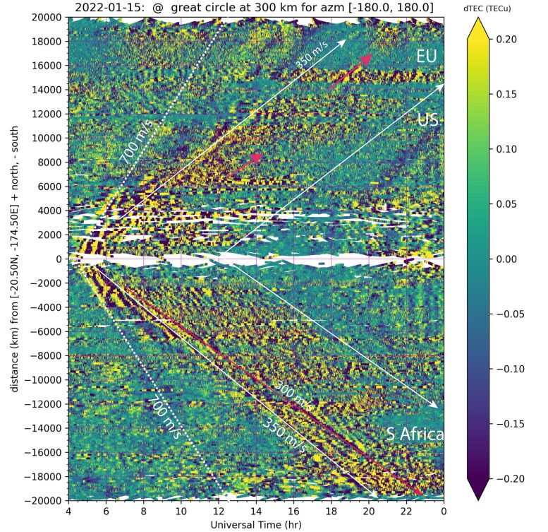
Traveling ionospheric disturbances following an eruption in the kingdom of Tonga in the South Pacific Ocean, as measured from the global GNSS networks of receivers. The horizontal axis shows time; the vertical axis shows distance. Yellow areas within the white-line envelope as marked by fiducial arrows are enhanced ionospheric disturbances in total electron content (TEC). Distance is measured along Great-Circle loci with origin at Tonga. The positive and negative distance shows TIDs propagating both northward and southward from Tonga. The eruption antipode is in North Africa, approximately 21,000 km away from Tonga. TIDs took 17-18 hours to reach the antipode and the same time to return to Tonga on the next day. Credit: Shunrong Zhang/Haystack Observatory

The authors believe the disturbances to be an effect of Lamb waves; these waves, named after mathematician Horace Lamb, travel at the speed of sound globally without much reduction in amplitude. Although they are located predominantly near Earth’s surface, these waves can exchange energy with the ionosphere through complex pathways. As stated in the new paper, “prevailing Lamb waves have been reported before as atmospheric responses to the Krakatoa eruption in 1883 and other geohazards. This study provides substantial first evidence of their long-duration imprints up in the global ionosphere.”

Under National Science Foundation support, Haystack has been assembling global GNSS network observations to study important total electron content information on a daily basis since 2000. The observatory shares this data with the international geospace community to enable innovative research on a variety of frontiers, ranging from solar storm effects to low atmospheric forcing. A particular form of space weather, caused by ionospheric waves called traveling ionospheric disturbances (TIDs), are often excited by processes including sudden energy inputs from the sun, terrestrial weather, and human-made disturbances. For example, Haystack scientists used TID observations to provide the first evidence that solar eclipses can trigger bow waves in Earth’s atmosphere.

Lead author Shunrong Zhang says, “Only severe solar storms are known to produce TID global propagation in space for several hours, if not for days; volcanic eruptions and earthquakes normally yield ionospheric disturbances only within thousands of kilometers. By detecting these significant eruption-induced ionospheric disturbances in space over very large distances, we found not only generation of Lamb waves and their global propagation over several days (often monitored as sound waves on the ground for compliance with Comprehensive Nuclear Test Ban Treaties) but also a fundamental new physical process. In the end, surface and lower atmospheric signals can make a loud splash, even deep in space.”

Beyond these results, Haystack scientists continue additional studies of the Tonga eruption’s generation of severe space weather effects.

Reference: “2022 Tonga Volcanic Eruption Induced Global Propagation of Ionospheric Disturbances via Lamb Waves” by Shun-Rong Zhang, Juha Vierinen2, Ercha Aa, Larisa P. Goncharenko, Philip J. Erickson, William Rideout, Anthea J. Coster and Andres Spicher, 23 March 2022, Frontiers in Astronomy and Space Sciences.
DOI: 10.3389/fspas.2022.871275

Describing the devastating eruption in Tonga


Date: March 29, 2022
Source: University of California - Santa Barbara

On January 15, the volcano Hunga Tonga-Hunga Ha'apai devastated the nation of Tonga. The eruption triggered tsunamis as far afield as the Caribbean and generated atmospheric waves that travelled around the globe several times. Meanwhile, the volcano's plume shot gas and ash through the stratosphere into the lower mesosphere.

Just two months after the eruption, geologists have put together a preliminary account of how it unfolded. UC Santa Barbara's Melissa Scruggs and emeritus Professor Frank Spera were part of an international team of researchers that published the first holistic account of the event in the journal Earthquake Research Advances. The authors think that an eruption the day before may have primed the volcano for the violent explosion by sinking its main vent below the ocean's surface. This enabled molten rock to vaporize a large volume of seawater, intensifying the volcanic eruption the very next day.

"This is definitely, without a doubt, the largest eruption since Mt. Pinatubo in 1991," said corresponding author Scruggs, who studies magma mixing and eruption triggering mechanisms, and recently completed her doctorate at UC Santa Barbara. She compared January's event to the 1883 eruption of Krakatoa, which was heard 3,000 miles away.

Hunga Tonga-Hunga Ha'apai (HTHH) is a stratovolcano: a large, cone-shaped mountain that is prone to periodic violent eruptions, but which usually experiences milder activity. It's one of many along the Tofua Volcanic Arc, a line of volcanoes fed by magma from the Pacific Plate diving beneath the Indo-Australian Plate. Heat and pressure cook the rocks of the descending plate, driving out water and other volatiles. That same water decreases the melting temperature of the rock above, leading to a chain of volcanoes about 100 kilometers from the plate boundary.

A submerged danger


The islands of Hunga Tonga and Hunga Ha'apai -- after which the volcano is named -- are merely the two highest points along the rim of the caldera, or central crater. Or they were, until the eruption blew most of the islands sky high.

Scruggs first heard about the eruption as she scrolled through her Twitter feed while getting ready for bed. "I saw a GIF of the satellite eruption, and my heart just stopped," she said, pausing to find her words. She immediately knew that the event would cause massive devastation. "The scariest part was that the entire country was cut off, and we didn't know what had happened."

She was already messaging other volcanologists as the events unfolded, trying to understand the images that satellites had so clearly captured. "We really just set out to try to understand what happened," Scruggs said. "So, we gathered all the information that we could, anything that was available within the first few weeks." The authors drew on whatever resources they could find to quickly characterize this eruption, including publicly available data, videos and even tweets.

Using a variety of data sets, the team calculated that the January 15 event began at 5:02 p.m. local time (0402 ±1 UTC). The U.S. Geological Survey recorded a seismic event around 13 minutes later at the vent location. The first two hours of the eruption were particularly violent, with activity fading after about 12 hours.

But eruption activity had actually started all the way back on December 20, 2021. And before that, the volcano had erupted in 2009 and again in 2014 and 2015. Scruggs believes these earlier episodes are key to understanding the violence behind HTHH's recent eruption, perhaps related to changes in the magma plumbing system at depth or the chemistry of the magma over time.

Hunga Tonga and Hunga Ha'apai used to be separate islands until they were united by eruptions from the volcano's main vent, which created a land bridge. "This island was just born in 2015," said Scruggs. "And now it's gone. Were it not for the satellite era, we would not have even known it ever existed."

On January 14, 2022 an explosion from the main vent razed this connection, sinking the vent beneath the ocean's surface. "Had that land bridge not been taken out, the January 15 eruption might have behaved just like the day before because it would not have had that excess seawater," Scruggs remarked.

A staggering explosion


Same volcano, one day's difference: On Friday the vent was above the water, and by Saturday it was below. "That made all of the difference in the world," Scruggs said.

The team believes that the seawater played a large part in the violence and force behind the Jan. 15 eruption. Much like a bottle rocket, an eruption of this scale takes the right ratio of water and gas to provide the force to send it skyward.

And it took off like a rocket, too. "It went halfway to space," Scruggs exclaimed. The ash plume shot 58 kilometers into the atmosphere, past the stratosphere and into the lower mesosphere. This is more than twice the height reached by the plume from Mt. Saint Helens in 1980. It was the tallest volcanic plume ever recorded.

A truly staggering amount of lightning also accompanied the eruption. The authors suspect that vaporizing seawater caused the lava to fragment into microscopic ash particles, which were joined by tiny ice crystals once the steam froze in the upper atmosphere. The motion, temperature change and size of the particles generated incredible amounts of static charge separation that flashed above the eruption. For the first two hours of the eruption, about 80% of all lightning strikes on Earth split the sky above Hunga Tonga-Hunga Ha'apai.

The authors estimate around 1.9 km3 of material, weighing 2,900 teragrams, erupted from HTHH on Jan. 15. "But the volume of the eruption was not the big deal," said Spera, a coauthor on the paper and Scruggs' doctoral advisor. "What was special is how the energy of the eruption coupled to the atmosphere and oceans: A lot of the energy went into moving air and water on a global scale."

The shockwave traveling through the ocean triggered tsunamis throughout the Pacific, and beyond. What's more, the wave arrived faster than tsunami warning models predicted because the models aren't calibrated for volcanic eruptions -- they're based on equations that describe tsunamis generated by earthquakes.

A second tsunami followed the atmospheric pressure wave. This shockwave even triggered a meteo-tsunami in the Caribbean, which has no direct connection to the South Pacific. Scruggs called it unprecedented: "Basically the whole ocean just kind of sloshed around for five days after the eruption," she added.

Plenty of work to do

Scientists are still piecing together what happened at the volcano, so they have yet to develop a complete understanding of the tsunami wave. However, it's an important task needed to update tsunami travel forecast systems so they account for this type of mechanism. Otherwise, warnings could be incorrect the next time a volcano like HTHH erupts, potentially costing more lives.

Indeed, the event highlights the danger posed by unmonitored submarine volcanoes. Despite the devastation, the people of Tonga were relatively well prepared for the Jan. 15 eruption. The government had issued warnings based on the previous day's activity, and the nation had plans in place for eruptions and tsunamis.

HTHH has experienced similarly violent eruptions in the past. A recent paper by researchers at the University of Otago, New Zealand revealed that a large eruption destroyed the caldera at the summit of the undersea volcano about 1,000 years ago. And similar volcanoes could well erupt in the same manner. Consider Kick 'em Jenny, another submarine volcano whose main vent is a mere 150 meters underwater. It's located just 8 km north of the island of Grenada. "Imagine if something like the Tonga eruption happened in the Caribbean," Scruggs said.

The researchers worked quickly with only publicly available data. They plan to revisit all their findings as more information and samples become available and as more researchers publish their own findings on this groundbreaking eruption. Their primary goal was to provide a point of departure for future work on the topic.

Scruggs is particularly keen on learning about the ash collected from this eruption. Volcanic rock provides a wealth of information to a trained geologist. Examining the material could shed light on the type of magma that erupted, how much of it there was and perhaps even how much seawater was involved in the eruption.

"There's so many questions that have been raised," said Scruggs. "Things we didn't even think were possible have now been recorded."

The UC Santa Barbara researchers will lead a special invited session on the Hunga Tonga-Hunga Ha'apai eruption at the Geological Society of America's 2022 annual meeting in Denver this October. "It will be exciting to see what scores of other earth scientists can discover about this unique volcano," Spera said. "We are just at the beginning."

Journal Reference:
David A. Yuen, Melissa A. Scruggs, Frank J. Spera, Yingcai Zheng, Hao Hu, Stephen R. McNutt, Glenn Thompson, Kyle Mandli, Barry R. Keller, Songqiao Shawn Wei, Zhigang Peng, Zili Zhou, Francesco Mulargia, Yuichiro Tanioka. Under the Surface: Pressure-Induced Planetary-Scale Waves, Volcanic Lightning, and Gaseous Clouds Caused by the Submarine Eruption of Hunga Tonga-Hunga Ha’apai Volcano Provide an Excellent Research Opportunity. Earthquake Research Advances, 2022; 100134 DOI: 10.1016/j.eqrea.2022.100134

With Environmental DNA, Small Water Samples Can Find Really Big Animals

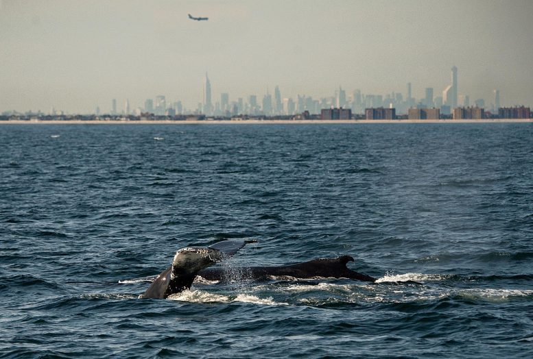
Humpback Whale in NY

Humpback whales now swim within sight of New York City. Credit: Julie Larsen Maher

Scientists say environmental DNA can detect whales and dolphins in New York waters.

  • Results are some of the most promising to date in the open Ocean
  • Massive renewable energy projects coming to the New York Bight could impact whales and dolphins

A team of scientists used an emerging genetic tool that analyzes DNA in water samples to detect whales and dolphins in New York waters.

Called environmental DNA or eDNA, the technique searches for trace amounts of genetic material left behind by wildlife.

The scientists, from California State University, CUNY, Wildlife Conservation Society (WCS), and Columbia University, published their results in the journal Frontiers.

The scientists say that eDNA can be used to complement other methods to locate whales and dolphins such as visual observations and acoustic monitoring, and their eDNA detections are some of the most promising to date for detecting whales and dolphins from seawater in the open ocean.

Said the study’s lead author Dr. Elizabeth Alter of California State University: “Determining how cetaceans and other threatened marine animals use coastal habitats is critical to their effective conservation. By generating eDNA data in parallel with survey data, it will be possible to gain a clearer understanding of how this tool can be used in management and conservation contexts to monitor species of conservation concern over large marine ecosystems.”

In addition to finding whales and dolphins, the technique detected baitfish present in the area preyed on by whales and dolphins. The authors say the technique could eventually be used to identify individual animals.

Said Dr. Howard C. Rosenbaum, Director of WCS’s Ocean Giants Program/Senior Scientist NY Aquarium and a co-author of the study: “Innovation and application of new techniques, such as the possibility of using eDNA, that leads to having better information about distribution of whales, dolphins and their prey is so important today, especially where potential impacts in these habitats may be increasing human activities.”

The authors say that eDNA drops to lower levels over time and that additional research is needed to better understand how factors such as behavior and oceanographic conditions contribute to the longevity of eDNA signals.

Though there are some signs of promising recovery for many whale species and populations, whales continue to face a range of modern day threats ranging from ship strikes, to entanglement with nets, to ocean noise.

The Biden-Harris administration, New York State and other states on the eastern seaboard are scaling up massive renewable energy projects to meet energy demands and help address climate change, including a wind energy auction for more than 488,000 acres in the New York Bight. There are many potential impacts from these developments to whales that the environmental community, industry, and state/federal authorities are aiming to address. WCS has been involved at state and national level dialogues as well as developing best practice guidance through the IUCN.

The use of emerging and novel techniques such as eDNA as demonstrated by the results of the current study in the NY Bight and other approaches can offer new insights as to whale presence and their prey in and around lease areas as offshore wind scales up along the eastern seaboard.  More broadly, WCS increasingly uses eDNA in its conservation work, detecting critically endangered wildlife such as Swinhoe’s softshell turtle, in the Bolivian Amazon, and in some of the most rugged areas on the planet including Mt. Everest.

Reference: “Using Environmental DNA to Detect Whales and Dolphins in the New York Bight” by S. Elizabeth Alter, Carissa D. King, Emily Chou, Sam Chew Chin, Melinda Rekdahl and Howard C. Rosenbaum, 11 February 2022, Frontiers in Conservation Science.
DOI: 10.3389/fcosc.2022.820377

DNA Testing Exposes Tactics of International Criminal Networks Trafficking Elephant Ivory Out of Africa

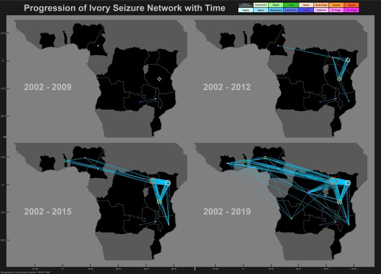
Ivory Networks

These maps illustrate shifts in smuggling operations over time to different African ports. Each solid dot represents an ivory seizure in that country. Blue lines indicate that two seizures are connected by genetic matches among tusks, physical evidence or both. Initially, savannah elephant ivory shipments were smuggled through Tanzania, Zambia and Malawi, but shifted to Kenya in 2010-2012 and Uganda in 2013-2015. Next, operations shifted to the Democratic Republic of the Congo and Angola in 2016-2019. Forest elephant ivory shipments shifted from Togo in 2013-2014 to Nigeria in 2016-2019, and showed connections to seizures in Central Africa. Credit: Wasser et al. 2022, Nature Human Behaviour

A team led by scientists at the University of Washington and special agents with the U.S. Department of Homeland Security has used genetic testing of ivory shipments seized by law enforcement to uncover the international criminal networks behind ivory trafficking out of Africa. The genetic connections across shipments that they’ve uncovered exposes an even higher degree of organization among ivory smuggling networks than previously known.

The paper, published recently in the journal Nature Human Behaviour, incorporates results from DNA testing of more than 4,000 African elephant tusks from 49 different ivory seizures made in 12 African nations over a 17-year period.

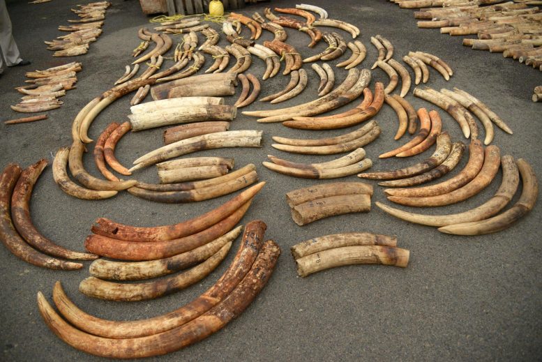
Tusks From 2015 Singapore Ivory Seizure

Tusks from an ivory seizure in 2015 in Singapore after they have been sorted into pairs by the process developed by Wasser and his team. Credit: Center for Environmental Forensic Science/University of Washington

Exposing the connections among separate ivory seizures — made at African and Asian ports sometimes thousands of miles apart — will likely boost evidence against the criminals arrested for elephant poaching and ivory smuggling, and strengthen prosecutions of the responsible transnational criminal organizations, according to lead author Samuel Wasser, a UW professor of biology and director of the Center for Environmental Forensic Science, whose group developed the genetic tools behind this work.

“These methods are showing us that a handful of networks are behind a majority of smuggled ivory, and that the connections between these networks are deeper than even our previous research showed,” said Wasser.

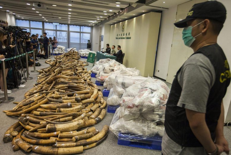
Tusks From 2017 Hong Kong Ivory Seizure

Tusks from an ivory seizure in 2017 in Hong Kong. Credit: WildAid

Illegal ivory trade — along with habitat loss, climate change and other factors — has decimated the two elephant species in Africa. Although ivory seizures by authorities come from elephants that have already been slaughtered, the tusks can provide valuable information by illuminating the poaching, shipment activities and connectivity of traffickers.

Previous work by Wasser and his collaborators — published in 2018 in the journal Science Advances — identified tusks from the same elephant that were separated and smuggled in different shipments prior to being seized by law enforcement. Finding both tusks from the same individual linked those seizures to the same trafficking networks. Those efforts indicated that, from 2011 to 2014, cartels tended to smuggle ivory out of three African ports: Mombasa, Kenya; Entebbe, Uganda; and Lomé, Togo.

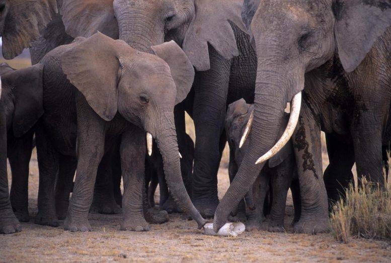
African Elephants Examine Bone

African elephants examine a bone from a fellow elephant. Credit: Karl Ammann

In this new endeavor, Wasser and his colleagues expanded their DNA analysis and testing regimen to also identify tusks of elephants that were close relatives — parents and offspring, full siblings and half-siblings. Adding close relatives expands the scope of the effort, Wasser said.

“If you’re trying to match one tusk to its pair, you have a low chance of a match. But identifying close relatives is going to be a much more common event, and can link more ivory seizures to the same smuggling networks,” said Wasser.

The team tested this expanded protocol on 4,320 tusks — from both forest elephants, Loxodonta cyclotis, and savannah elephants, Loxodonta africana — from 49 separate large shipments totaling 111 metric tons of ivory, all seized from 2002 to 2019. Results showed that a majority of these shipments could be linked based on matching tusks either from the same individual or from close relatives.

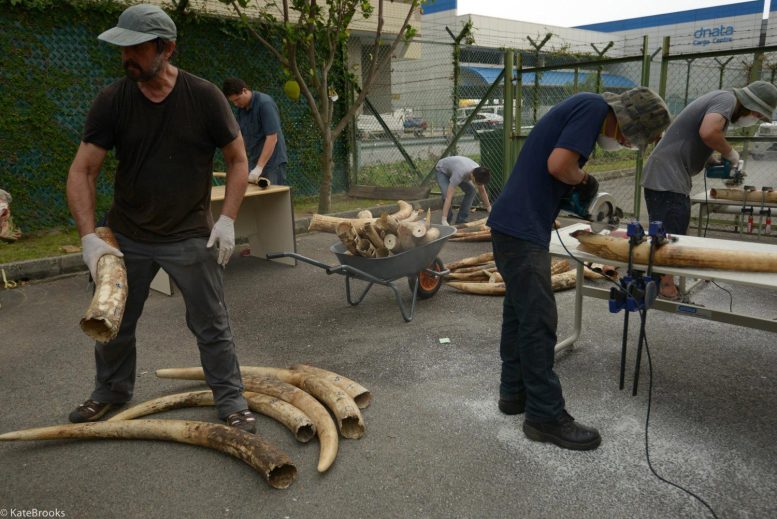
Sampling Ivory in Singapore

Wasser (left) and his team sort tusks from a seizure in Singapore in 2015 and use saws to cut away ivory samples for subsequent DNA extraction and genetic analysis. Credit: Kate Brooks

“Identifying close relatives indicates that poachers are likely going back to the same populations repeatedly — year after year — and tusks are then acquired and smuggled out of Africa on container ships by the same criminal network,” said Wasser. “This criminal strategy makes it much harder for authorities to track and seize these shipments because of the immense pressure they are under to move large volumes of containers quickly through ports,” said Wasser.

The genetic data show that a handful of interconnected smuggling networks are likely behind most large ivory shipments, most often exported from ports in Kenya, Uganda and Nigeria. By expanding the analysis to identify tusks from close relatives, the team could also link seizures from a dozen countries in Central and West Africa, stretching from Ivory Coast on the Atlantic Ocean to Mozambique on the Indian Ocean.

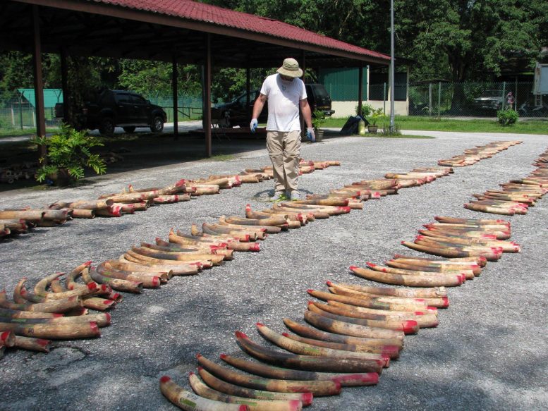
Tusks From Ivory Seizure in Malaysia

Tusks from a seizure in Malaysia in 2012. Credit: Malaysia Department of National Parks

The larger analysis also can track how smuggling networks shifted their operations to different ports over time: from Tanzania in the early 2000s; then to Kenya and Uganda; and, most recently, to Angola and the Democratic Republic of the Congo. In West Africa, a temporal shift occurred from Togo to Nigeria.

“By linking individual seizures, we’re laying out whole smuggling networks that are trying to get these tusks off the continent,” said Wasser.

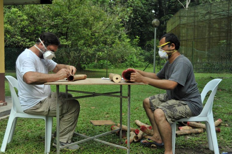
Sampling Ivory in Malaysia

Wasser (left) and his team sample ivory from tusks in Malaysia in 2014. Credit: Malaysia Department of National Parks

The criminals behind one ivory seizure would have been prosecuted solely for that seizure. But the genetic evidence by Wasser and his team could strengthen investigations and prosecutions by linking responsible transnational criminal organizations to multiple seizures — leading to more severe penalties.

Reference: “Elephant genotypes reveal the size and connectivity of transnational ivory traffickers” by Samuel K. Wasser, Charles J. Wolock, Mary K. Kuhner, John E. Brown III, Chris Morris, Ryan J. Horwitz, Anna Wong, Charlene J. Fernandez, Moses Y. Otiende, Yves Hoareau, Zofia A. Kaliszewska, Eunjin Jeon, Kin-Lan Han and Bruce S. Weir, 14 February 2022, Nature Human Behaviour.
DOI: 10.1038/s41562-021-01267-6

Co-authors are Charles Wolock, a UW doctoral student in biostatistics; John Brown III with the U.S. Department of Homeland Security; UW biology research scientists Mary Kuhner, Yves Hoareau, Eunjin Jeon and Zofia Kaliszewska; Kin-Lan Han, a former UW researcher who is currently a geneticist with the U.S. Fish and Wildlife Service; Chris Morris with SeeJ-Africa in Nairobi, Kenya; Ryan Horwitz, who was at the University of Michigan and is now a UW research scientist; Anna Wong and Charlene J. Fernandez with the National Parks Board of Singapore; and Moses Otiende with the Kenya Wildlife Service.

The research was funded by the Paul and Yaffe Maritz Family Foundation, the Wildlife Conservation Network, the Elephant Crisis Fund, the U.N. Development Program, the Paul G. Allen Family Foundation, the Woodtiger Fund, the Wildcat Foundation, the U.S. Department of State, U.S. Department of Homeland Security, HSI, the World Bank, the U.N. Office on Drugs and Crime, the National Institute of Justice and the National Institutes of Health.

Grant numbers: 2020-DQ-BX-0022, GM075091