Calibrating the zenith of dinosaur diversity in the Campanian of the Western Interior Basin by CA-ID-TIMS U–Pb geochronology
Scientific Reports 12, Article number: 16026 (2022)
Abstract
The spectacular fossil fauna and flora preserved in the Upper Cretaceous terrestrial strata of North America’s Western Interior Basin record an exceptional peak in the diversification of fossil vertebrates in the Campanian, which has been termed the ‘zenith of dinosaur diversity’. The wide latitudinal distribution of rocks and fossils that represent this episode, spanning from northern Mexico to the northern slopes of Alaska, provides a unique opportunity to gain insights into dinosaur paleoecology and to address outstanding questions regarding faunal provinciality in connection to paleogeography and climate. Whereas reliable basin-wide correlations are fundamental to investigations of this sort, three decades of radioisotope geochronology of various vintages and limited compatibility has complicated correlation of distant fossil-bearing successions and given rise to contradictory paleobiogeographic and evolutionary hypotheses. Here we present new U–Pb geochronology by the CA-ID-TIMS method for 16 stratigraphically well constrained bentonite beds, ranging in age from 82.419 ± 0.074 Ma to 73.496 ± 0.039 Ma (2σ internal uncertainties), and the resulting Bayesian age models for six key fossil-bearing formations over a 1600 km latitudinal distance from northwest New Mexico, USA to southern Alberta, Canada. Our high-resolution chronostratigraphic framework for the upper Campanian of the Western Interior Basin reveals that despite their contrasting depositional settings and basin evolution histories, significant age overlap exists between the main fossil-bearing intervals of the Kaiparowits Formation (southern Utah), Judith River Formation (central Montana), Two Medicine Formation (western Montana) and Dinosaur Park Formation (southern Alberta). Pending more extensive paleontologic collecting that would allow more rigorous faunal analyses, our results support a first-order connection between paleoecologic and fossil diversities and help overcome the chronostratigraphic ambiguities that have impeded the testing of proposed models of latitudinal provinciality of dinosaur taxa during the Campanian.
Introduction
Continental sedimentary successions are important archives of terrestrial flora and fauna, as well as the paleoenvironmental conditions that dominated the continents in the geologic past. However, establishing the tempo and patterns of evolution in relation to documented climatic and geologic changes is limited by the ability to precisely date and correlate fossil-bearing strata. Understanding the depositional history of continental records in absolute time thus has multiple scientific merits: (1) it makes it possible to place geographically scattered fossil occurrences in a proper chronostratigraphic framework as a basis for paleobiologic interpretations, (2) it allows the construction of time-calibrated records of terrestrial paleoenvironmental change (e.g., climatic and geologic) in which possible links to the coeval biotic evolution can be explored, (3) it facilitates correlation of the continental biotic records to the marine biostratigraphy upon which the geologic time scale has been built and, (4) it enables transcontinental correlation of biotic and paleoenvironmental records as a basis for assessing global evolutionary and paleoecologic models. Unravelling the detailed depositional history of continental successions is nevertheless challenging because of the inherently discontinuous nature of non-marine sedimentation in space and time and the paucity of diagnostic, age-specific fossils in this setting. As such, radioisotopic geochronology plays a crucial role in constructing reliable chronostratigraphic frameworks for continental successions by providing temporal tie lines independent of often equivocal litho-, bio- or magneto-stratigraphic correlations.
The Western Interior Basin (WIB) of North America (Fig. 1) contains extensive exposures of Upper Cretaceous rocks preserving a spectacular fossil record. In particular, the Campanian stage (ca. 84–72 Ma) is unparalleled for exposures of vertebrate-bearing continental strata on the northern continents and has been termed the ‘zenith’ of dinosaur diversity1,2,3,4. The cause(s) of the inferred Campanian diversification remains poorly understood and related evolutionary models have not been adequately tested. A subject of particular debate is whether or not the Campanian dinosaur record of the WIB exhibits a latitudinal provinciality5,6,7. Moreover, whether or not the remarkable faunal richness of the Campanian is a taphonomic/preservational artefact or signifies a true increase in biologic diversity remains a matter of debate8,9. Addressing these questions requires a thorough understanding of environmental controls on fossil preservation, sampling bias in collections, and high-resolution correlations between outcrop areas along nearly 2000 km of strike, as well as control on the tempo of climate and biological changes.
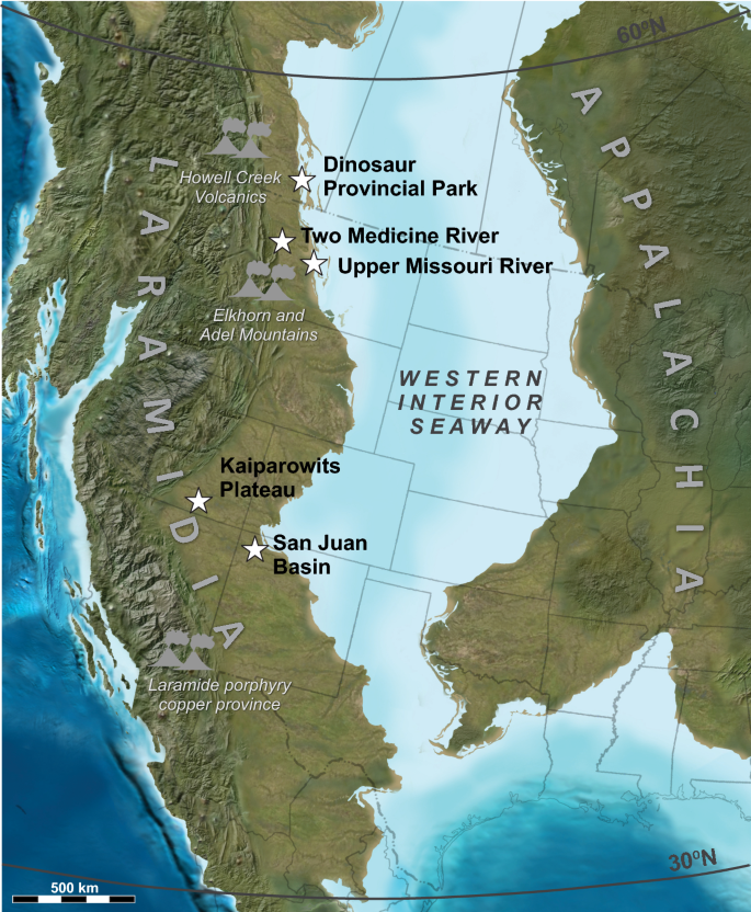
Paleogeographic reconstruction of the North American continent in the late Campanian illustrating the areal expanse of the Western Interior Seaway separating the Laramidia and Appalachia landmasses, after Blakey33. Our study locations are marked by stars. Potential centers of coeval arc volcanism are also indicated.
Biotic evolution during the Campanian transpired against a background of profound environmental change, including a global increase in atmospheric temperatures and an abrupt rise in sea levels that flooded low lying continental regions10,11,12. The Campanian was also a time of widespread explosive volcanism in Montana (Elkhorn Mountain and Adel volcanics) and British Columbia (Howell Creek volcanics), but also farther to the south in Texas, southern Arizona, southern New Mexico and northern Mexico13,14,15,16,17,18 (Fig. 1). Easterly Campanian trade winds transported volcanic ash from western and southern sources into the WIB19,20,21,22, depositing numerous ash beds that are intercalated throughout the stratigraphic succession. During the last 25 years, 40Ar/39Ar (and K–Ar) geochronology has been widely utilized to date Upper Cretaceous strata throughout the WIB, in particular the bentonite (devitrified and altered volcanic ash) horizons, to constrain ammonite biozones23,24. Similarly, a number of continental sedimentary successions, including the Campanian Two Medicine25, Judith River26, Dinosaur Park27, Kaiparowits28, Kirtland, and Fruitland29 formations were targeted for geochronology because of their rich vertebrate fossil records. This has facilitated correlation of stratigraphic sections and faunas across the marine and non-marine WIB. However, this and subsequent bodies of work were conducted over more than three decades in different laboratories and by implementing different analytical protocols, resulting in many vintages of geochronologic data that in many cases lack compatibility. This has hampered a full interrogation of the WIB paleontologic, sedimentologic, and paleoclimatologic records. Radioisotopic geochronologic techniques have improved dramatically over the past decade and it is now possible to build age models for Cretaceous rocks at the millennial to decamillennial scales30,31,32. This, in turn, affords new opportunities to examine trends in geological and paleontological records at high resolution.
Here we present a set of internally consistent geochronologic data from five of the most richly fossiliferous Campanian continental successions—namely the Dinosaur Park, Two-Medicine, Judith River, Kaiparowits and Fruitland/Kirtland formations. These units are separated by as much as 1600 km and 15 degrees of paleolatitude along the WIB forelands. The geochronology presented in this paper is unique compared to previous studies in that it is based entirely on high-precision U–Pb analyses of bentonitic zircon by the CA-ID-TIMS method and that it employs the latest, community-wide, analytical practices and protocols. Our new geochronology provides bed-level correlation of bentonites and fossil-rich stratigraphic intervals across the study areas and serves as a foundation for basin-wide study of the Campanian dinosaur record. The results place in context a large and growing body of paleontologic, sedimentologic and paleoecologic data that has been collected throughout the WIB, providing an opportunity to evaluate temporal relationships among well studied floras and faunas and test hypotheses relating to latitudinal provinciality across Laramidia.
Laramidian stratigraphy and geological setting
The meridional Western Interior Seaway (WIS) covered vast areas of North America from Alaska to Mexico33, bisecting the continent during much of the Cretaceous Period and isolating a narrow western landmass (Fig. 1) referred to as Laramidia34. The shorelines of the WIS transgressed and regressed throughout its history in response to climatic and/or tectonic drivers. The Cretaceous alluvial and coastal plain deposystems that formed along the western shores of this vast epicontinental seaway archive a rich record of well-preserved vertebrates, invertebrates and plants. A long history of fossil collection (> 100 years) has rendered Laramidia a cornerstone of Mesozoic paleobiogeographic research on dinosaurs and numerous other land floral and faunal groups.
Continental Upper Cretaceous strata are well-preserved across western North America, from Alaska to Mexico (Figs. 1, 2). Not surprisingly, a census of Mesozoic vertebrate fossil occurrences in North America using the Paleobiology Database (paleobiodb.org/) reveals a significant spike in fossil preservation during the Late Cretaceous, with greatest diversity and fossil abundance linked to the Campanian and Maastrichtian stages1,4. A closer inspection of the database demonstrates that the majority of these fossils come from relatively few stratigraphic units and indeed, represent fairly narrow temporal windows. The second half of the Campanian (ca. 77–72 Ma) is arguably the richest interval within this time frame and is highlighted by especially large curated collections from Alberta, Montana, Utah, and New Mexico. The bulk of the fossil occurrences are known from a few key regions of the WIB, including Alberta (Oldman and Dinosaur Park formations), Montana (Two Medicine and Judith River formations), Utah (Wahweap and Kaiparowits formations), and New Mexico (Kirtland and Fruitland formations) (Figs. 1, 2).
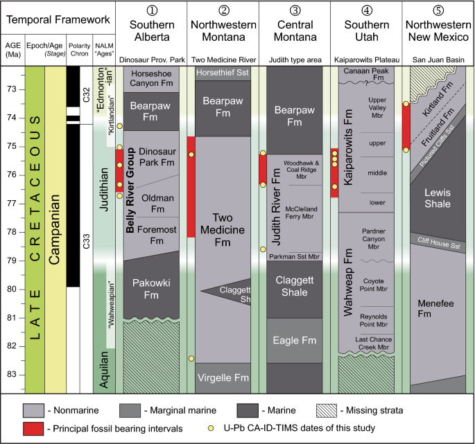
Correlation chart of rock formations and principal vertebrate-bearing continental deposits of Campanian age in the Western Interior Basin, modified from Roberts et al.105 with new data86,114,126 and the results of this study. Shown in red are the calibrated temporal ranges of principal fossil-bearing intervals (excluding uncertainties). Fm, Formation; Mbr, Member; NALM, North American Land Mammal; Sh, shale; Sst, sandstone.
Dinosaur Provincial Park, Alberta, Canada
The Upper Cretaceous Belly River Group of Alberta has yielded arguably the most diverse and best sampled Cretaceous terrestrial fossil assemblage in the world35. It consists in ascending order of the Foremost, Oldman, and Dinosaur Park formations (Fig. 2), which are overlain by the marine shales of the Bearpaw Fm.36,37. The thickness of the three formations at Dinosaur Provincial Park (based on both surface and subsurface data) are approximately 170 m, 40 m, and 70 m, respectively37, with the Oldman and Dinosaur Park formations locally exhibiting thicknesses up to ca. 50 and 80 m, respectively, due to differential compaction on stacked sandstones and local paleochannel relief at the base of the Dinosaur Park Fm.
The paralic to non-marine (alluvial) clastic sediments of the Foremost Formation (Fm.) are organized into progradational to aggradational stratigraphic packages that reflect an overall regressive WIS trend37. Two prominent coal zones (McKay and Taber) are present in the lower and upper portions of the formation, respectively. The overlying Oldman Fm. is part of an east-northeast-expanding clastic wedge originating in northwest Montana that records maximum regression of the WIS into south-central Saskatchewan37. It consists of a variety of fluvial and floodplain facies deposited seasonally across a relatively well-drained landscape. A subsequent transgressive phase of the WIS is recorded in the overlying bentonite-rich, alluvial-to-paralic facies of the Dinosaur Park Fm. The stratigraphically lower one-half of the formation is dominated by paleochannel deposits that are unusually rich in bone-beds and articulated-to-associated skeletons of large dinosaurs35,37. The formation culminates upsection in the Lethbridge Coal Zone (LCZ), a package of tidally influenced wetland-to-shoreline deposits (including up to four coal beds)38 that interfinger with—and are overlain by—marine shales of the Bearpaw Fm.
The Oldman and Dinosaur Park formations are well exposed and extensively sampled at Dinosaur Provincial Park, yielding many hundreds of articulated and associated dinosaur specimens, and thousands of isolated elements from more than 140 species of vertebrates35,39,40,41,42,43,44,45,46. Fossil collection in the Park has been conducted for more than a century, although a viable stratigraphic framework for the fossils is a more recent development35,45,47,48. Radioisotopic geochronology in the Park extends back to the early 1990’s, but was developed in piecemeal fashion27,36. Seven stratigraphically discrete bentonite horizons have been documented49, with 40Ar/39Ar ages that range from 76.5 ± 1.0 Ma to 74.9 ± 0.2 Ma (2σ internal uncertainties hereafter, unless specified otherwise).
Western and central Montana, USA
To the south of the international border in Montana, the richly fossiliferous Two Medicine and Judith River formations form an eastward thinning clastic wedge of alluvial, coastal plain, and shallow marine strata deposited during the Campanian50. The strata of the Two Medicine Fm. crop out in northwestern Montana and represent the more proximal alluvial plain environments of the Two Medicine-Judith River wedge. The sedimentology and taphonomy of the unit are consistent with accumulation under seasonal, semi-arid conditions50,51,52. The alluvial deposits of the Two Medicine Fm. are truncated by the Cordilleran thrust front to the west and are separated from the more distal outcrop belt of the correlative Judith River Fm. to the east by the Sweetgrass arch.
The ca. 550-m-thick Two Medicine Fm. is well known for its dinosaur fauna, and especially the exquisite preservation of dinosaur nests and hatchlings51,53,54,55,56,57. Vertebrate fossil collection in the unit began more than a century ago, and Two Medicine deposits have yielded one of the best documented Cretaceous vertebrate assemblages in the world. Rogers et al.25 undertook a comprehensive geochronologic study in the Two Medicine Fm. based on 40Ar/39Ar analyses of primarily plagioclase and biotite (and one sanidine), and reported dates from five bentonite beds that ranged from 80.00 ± 0.56 Ma to 74.08 ± 0.19 Ma , spanning most of the formation in its type area. Subsequent 40Ar/39Ar work (sanidine and plagioclase) by Foreman et al.58 added an additional date of 77.52 ± 0.38 Ma to a bentonite intercalated in the approximate middle of the formation. Varricchio et al.59 reported 40Ar/39Ar analyses (plagioclase and biotite), as well as U–Pb zircon geochronology by the SIMS method from multiple bentonites associated with a prominent hadrosaur bone bed in the southern Two Medicine outcrop belt. Their geochronology from strata attributed to the uppermost Two Medicine Fm. resulted in an 40Ar/39Ar plateau age of 75.92 ± 0.64 Ma, whereas the youngest measured single zircon U–Pb date was 74.0 ± 1.8 Ma59. The published radioisotopic geochronology from Two Medicine Fm. spans much of the spatial and temporal distribution of the formation from ca. 80 Ma to 74 Ma, with highly variable 2σ internal uncertainties (± 0.19 to ± 1.8 Myr) and accuracies (Supplementary Table S1). A temporally calibrated stratigraphy with adequate resolution between key fossil localities has never been compiled.
The ca. 180-m-thick Judith River Fm. is widely exposed along the Missouri River corridor in north-central Montana, within the confines of the Upper Missouri River Breaks National Monument. Stratigraphic research during the mid-to-late nineteenth and early twentieth centuries on the age and correlation of the Judith River Fm. was instrumental in resolving the basic stratigraphy of the Western Interior Cretaceous section60,61,62,63,64,65,66. The unit is also significant to the history of vertebrate paleontology, with some of the first skeletal remains of dinosaurs described from North America recovered from the Judith River strata near the confluence of the Judith and Missouri Rivers67,68,69,70. The Judith River Fm. has continued to be a major focus of paleontological research to the present day71,72,73,74,75,76,77,78,79,80,81,82.
Among the earliest 40Ar/39Ar geochronology from the Campanian of the WIB were the sanidine analyses of Goodwin and Deino26 from two bentonite beds associated with the Taber Coal Zone of the lower Judith River Fm. in Kennedy Coulee, northern Montana. More recently, Rogers et al.83 reported three 40Ar/39Ar sanidine ages from the Judith River Fm. and overlying strata in its type area in central Montana, ranging from 76.24 ± 0.36 Ma to 75.21 ± 0.24 Ma.
Kaiparowits Plateau, Utah, USA
The Campanian strata of the Kaiparowits Plateau encompass the Wahweap and Kaiparowits formations, which were deposited in the southern part of the WIB. The Wahweap Fm. is a ca. 400-m-thick succession of channel sandstones and floodplain mudstones of fluvial and estuarine origin deposited by meandering rivers under a seasonal climate84,85,86. Its sedimentation was largely influenced by transgression of the WIS until a tectonically-driven drop in the base level led to a change in depositional setting and sediment source reflected in its uppermost Pardner Canyon (capping sandstone) Member. This change is represented at the member’s lower boundary by prominent channel incisions into the underlying strata87.
The overlying 1005-m-thick Kaiparowits Fm.88,89 represents extensive flood basin pond, lake, and river deposition on a low-relief alluvial plain characterized by a warm, subhumid paleoenvironment90. High volcanic input and rapid rock accumulation rates due to active tectonic subsidence characterizes this unit28,91,92. The Kaiparowits Fm. preserves an abundant and remarkably diverse flora and fauna ranging from invertebrates to large vertebrates7,93,94.
Documentation of the fossil vertebrates and stratigraphy of the Kaiparowits and Wahweap formations extends back to the 1930’s, although very little work transpired in this region due to its remoteness until the 1980’s, when the importance of the mammalian and other microfossils from these units was recognized95,96. Renewed interest in macrofossils from the Kaiparowits Fm. began in the early 2000s and has led to many new discoveries of vertebrate, invertebrate, and plant macrofossils, including many new dinosaur species. As a result of these efforts, the fossil record of southern Utah now eclipses that of most other Cretaceous formations in North America in terms of diversity and abundance7,97,98,99,100,101,102,103,104.
A high resolution stratigraphic record has been developed in parallel to vertebrate fossil exploration in the Kaiparowits Fm., which has resulted in the identification of at least 10 discrete bentonite horizons28,105. 40Ar/39Ar dating of sanidine was used to determine depositional ages for five of these bentonites, which ranged from 75.97 ± 0.36 Ma to 74.69 ± 0.36 Ma.
San Juan Basin, New Mexico, USA
The non-marine Campanian succession of the San Juan Basin (northwestern New Mexico and southwestern Colorado) consists of the Fruitland Fm. and the overlying Kirtland Fm.106, with a maximum combined thickness in excess of 300 m in portions of the basin. The coal-bearing Fruitland Fm. consists of sandstones, siltstones, and carbonaceous shales that were deposited in a nearshore swamp setting on top of the regressive shoreline beds of the Pictured Cliff Sandstone107. It grades upward (and laterally) into the predominantly fluvial sandstones and shales of the Kirtland Fm., which in turn is overlain unconformably by the early Paleocene Ojo Alamo/Animas Fm.108. The strongly transitional and time-transgressive nature of the contact between the Fruitland and Kirtland formations complicates their lithostratigraphic division across the basin107.
Vertebrate fossil collections from the Upper Cretaceous strata of the San Juan Basin extend back over 100 years, with early collecting efforts led by Hay109 and Gilmore110,111. Since then, thousands of specimens have been collected, with the richest stratigraphic intervals characterized by two main “local” faunas, namely the Hunter Wash and Willow Wash local faunas112,113.
The earliest published radioisotopic dates for the Fruitland and Kirtland formations are those of Fassett and Steiner29, who reported 40Ar/39Ar sanidine dates for five bentonites distributed throughout the Fruitland-Kirtland succession. These 40Ar/39Ar ages (compiled in Fassett107) range from 75.56 ± 0.41 Ma (Huerfanito Bentonite Bed) at the base of the Fruitland Fm to 73.04 ± 0.25 Ma (Ash J) at the top of the Kirtland Fm., although most are within error of each other, limiting their utility for fine temporal resolution. More recent 40Ar/39Ar geochronology from three bentonites (DEP, Ash 2 and Ash J) in this succession have resulted in improved precision and accuracy114.
CONTINUE READING:


