Friday, August 18, 2023


NASA's lunar trailblazer gets final payload for moon water hunt

NASA’s Lunar Trailblazer Gets Final Payload for Moon Water Hunt
NASA’s Lunar Trailblazer is shown here during thermal vacuum chamber (TVAC) testing at 
Lockheed Martin Space in Littleton, Colorado, in June 2023.
 Credit: Lockheed Martin Space

NASA's Lunar Trailblazer is nearing completion now that its second and final cutting-edge science instrument has been added to the small spacecraft. Built by the University of Oxford in England and contributed by the UK Space Agency, the Lunar Thermal Mapper (LTM) joins the High-resolution Volatiles and Minerals Moon Mapper (HVM3), which was integrated with the spacecraft late last year. Together, the instruments will enable scientists to determine the abundance, location, and form of the moon's water.

Led by Caltech in Pasadena, California, Lunar Trailblazer has a mass of about 440 pounds (200 kilograms) and measures only 11.5 feet (3.5 meters) wide with its solar panels fully deployed. The small satellite will rely on the LTM instrument to gather temperature data that will reveal the thermal properties of the lunar surface and the composition of silicate rocks and soils. The HVM3 imaging spectrometer, which was built by NASA's Jet Propulsion Laboratory in Southern California, will detect and map the form, abundance, and locations of water in the same regions as the LTM instrument.

"Lunar exploration is an international endeavor, and Lunar Trailblazer embodies that spirit with the University of Oxford's and UK Space Agency's contribution to the mission," said Bethany Ehlmann, the mission's principal investigator at Caltech. "With the combined power of both of these sophisticated instruments, we can better understand where and why water is on the moon and support the next era of moon exploration."

Launching before the Artemis program's human landings, Lunar Trailblazer will return information about the moon's water, providing maps to guide future robotic and human explorers. Lunar water could be used in a variety of ways, from purifying it as drinking water to processing it for fuel and breathable oxygen.

"The Lunar Trailblazer mission will improve our understanding of our natural satellite and how we could harness its resources to support exploration in the future," said Libby Jackson, Head of Space Exploration at the UK Space Agency. "Backing missions and capabilities that will drive opportunities for humanity to venture deeper into space is one of our priorities, so it's exciting to see the LTM instrument ready for launch."

Lunar Trailblazer was selected by NASA's SIMPLEx (Small Innovative Missions for Planetary Exploration) program in 2019, and the spacecraft will launch as a secondary payload on the second Intuitive Machines robotic lunar lander mission, called IM-2. That launch, which will also carry NASA's Polar Resources Ice Mining Experiment-1 subsurface ice drill, is expected no earlier than early 2024.

Lunar water cycle

When Lunar Trailblazer arrives in orbit around the moon, it will use HVM3 to map the spectral fingerprints—or wavelengths of reflected sunlight—of the different forms of water over the lunar landscape. LTM will scan those mapped regions at the same time to form an image that can be used to characterize the temperature of the surface. By measuring the same locations at different times of day, Lunar Trailblazer will determine if the amount of water changes on this airless body.

It is thought that some water molecules might be locked inside lunar rock and regolith (broken rock and dust), particularly those containing silicates, which are the most abundant mineral on the moon. Other water molecules may move and settle for short periods as frost in cold shadows.

As the sun changes position in the sky during the lunar day, the shadows move. This causes the ice to sublimate, transforming into vapor without passing through a liquid phase. As the water molecules move in the moon's extremely thin atmosphere to other cold places, they can settle once more as a frost. The most likely locations to hold water ice in significant quantities are the always-cold permanently shadowed craters at the lunar poles, which are key targets for science and exploration.

"LTM precisely maps the surface temperature of the moon while the HVM3 instrument looks for the spectral signature of ," said Neil Bowles, instrument scientist for LTM at the University of Oxford. "Combining the measurements from both instruments allows us to understand how surface temperature affects water, improving our knowledge of the presence and distribution of these molecules on the moon."

LTM will provide maps of lunar surface temperature from about minus 265 degrees to 266 Fahrenheit (minus 165 degrees to 130 Celsius) using four broadband infrared channels. The instrument will scan the lunar surface to form a multispectral image as the spacecraft orbits above. At the same time, 11 narrow infrared channels also map small variations in the composition of silicate minerals that make up the rocks and regolith of the moon's surface, providing more information about what the  is made of and how this may influence the amount of  present.

Lunar Trailblazer is undergoing final assembly and testing at Lockheed Martin Space in Littleton, Colorado, and the spacecraft recently completed thermal vacuum chamber testing that simulates the harsh environment of space. Now, with both instruments integrated with the spacecraft and undergoing final system-level testing, Lunar Trailblazer is approaching readiness to ship to Florida for final launch preparations.

Provided by NASA 

Moon water imager integrated with NASA's Lunar Trailblazer

NASA's tale of two towers: Both Artemis mobile launchers see action

rocket
Credit: CC0 Public Domain

NASA's Artemis program has one tower standing and one just getting started.

Mobile launcher 1 (ML-1), which endured some significant damage after its use on the Artemis I mission last November, has been undergoing repairs and enhancements in preparation for its reuse on next year's planned Artemis II flight, the first with humans on board.

NASA stuck the 380-foot-tall structure atop its slow-moving crawler-transporter 2 on Wednesday at Kennedy Space Center to begin its two-day return to Launch Pad 39-B.

ML-1 is the ground structure that holds NASA's powerful Space Launch System rocket, and for Artemis II, NASA has been working to add essential features for the four humans that will be riding in the Orion capsule atop the rocket. It will make its way into the Vehicle Assembly Building for eventual stacking of all the rocket parts early next year.

For now, though, it has work planned at the launch site where NASA's Exploration Ground Systems team will perform tests and work on upgrades for both the launcher and the launch pad. That includes a launch day demonstration for the Artemis II crew of NASA astronauts Reid Wiseman, Victor Glover, Christina Koch and Canadian astronaut Jeremy Hansen as well as NASA's closeout crew and the .

The rescue teams will make sure the emergency exit system works in the event the astronauts and other support crew need to escape from their spacecraft to the safety of the ground below. The system has four baskets that can hold up to five people that travel down large cables to staged vehicles below.

Unlike the Space Shuttle Program, which had a tower permanently constructed at the launch pad, the mobile launchers require the emergency egress systems to be assembled and disassembled between every SLS launch.

NASA will also be able to test upgraded umbilical lines including the flow of liquid hydrogen from a new storage sphere. Liquid hydrogen leaks plagued both dress rehearsals and several launch attempts before the eventual successful liftoff of Artemis I on Nov. 16, 2022.

Meanwhile, Bechtel National Inc., NASA's prime contractor to construct a sister mobile launcher, bolted together the first pieces of steel Wednesday at KSC for what will end up being the even bigger mobile launcher 2 (ML-2). The slightly taller platform will be 390 feet tall.

The need for a second mobile launcher is driven by what will be a version of SLS that's 40 feet taller called the Block 1B. The height increase is due to SLS getting rid of what's called the Interim Cryogenic Propulsion Stage (ICPS) used to propel the Orion space capsule to the moon in favor of the more powerful and roomier Exploration Upper Stage beginning with Artemis IV, a mission currently on NASA's roadmap for no earlier than 2028.

The steel trusses and girders will come together as it takes shape, eventually to be assembled at the mobile launcher parking lot that's adjacent to the VAB.

"I am proud of our team for achieving this  in partnership with NASA," said Bechtel Project Manager Felice Presti in a press release. "It is incredible to see the complex designs of my Bechtel colleagues come together in this new, innovative structure that will support the SLS rocket and NASA's Artemis mission to further deep space exploration. I look forward to continuing safe progress on the mobile launcher as we work from bolting to liftoff."

When finished, the ML-2 will weigh about 11.3 million pounds and be able to support the Block 1B version as well as a planned Block 2 version of SLS that is planned to have even more power at liftoff than the first Artemis missions, which produce 8.8 million pounds of thrust on liftoff, and to date is the most powerful rocket to ever reach orbit.

Bechtel was awarded the original contract to construct ML-2 in 2019 for $383 million with a completion originally promised by spring 2023. Cost increases and design delays piled on through 2022 prompting NASA's Office of the Inspector General to audit the program. Its findings released last June showed the total projected cost was already expected to hit $960.1 million, or 2 1/2 times more than originally planned.

Delivery now is officially delayed until October 2025, but the audit suggests even that date won't be attainable.

"We expect further cost increases as inevitable technical challenges arise when ML-2 construction begins," the audit reads. "Given the time NASA requires for additional testing once the structure is delivered, the earliest the ML-2 will be available for Artemis IV is November 2026."

2023 Orlando Sentinel.

Distributed by Tribune Content Agency, LLC.

NASA Artemis I moon rocket rolls back to Kennedy Space Center launch pad

The clouds on Neptune perform a surprise disappearing act

Clouds On Neptune Perform A Surprise Disappearing Act
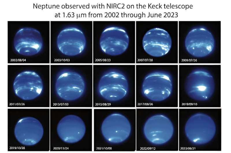
A dramatic change in Neptune’s appearance was observed in late 2019 and has persisted
 through June 2023. As shown by this compilation of images at 1.63 µm (microns) obtained
 with the NIRC2 and adaptive optics system on the Keck II Telescope, Neptune had 
numerous cloud features organized in latitudinal bands from before 2002 through late
 2019. Afterwards, clouds appeared almost absent except near the south pole. The 
images are displayed using a Asinh function which, like a log-scale display, decreases the
 contrast between the features; if displayed on a linear scale, only the brightest features 
would be visible. 
Credit: Imke de Pater, Erandi Chavez, Erin Redwing (UC Berkeley)/W. M. Keck Observatory

For the first time in nearly three decades of observations, clouds seen on Neptune have all but vanished. Images from 1994 to 2022 of the big blue planet captured from Maunakea on Hawaiʻi Island through the lens of W. M. Keck Observatory, along with views from space via NASA's Hubble Space Telescope show clouds are nearly gone with the exception of the south pole.

The observations, which are published in the journal Icarus, further reveal a connection between Neptune's disappearing clouds and the —a surprising find given that Neptune is the farthest major planet from the sun and receives only 1/900th of the sunlight we get on Earth.

A University of California (UC) Berkeley-led team of astronomers discovered the abundance of clouds normally seen at the icy giant's mid-latitudes started to fade in 2019.

"I was surprised by how quickly clouds disappeared on Neptune," said Imke de Pater, emeritus professor of astronomy at UC Berkeley and senior author of the study. "We essentially saw cloud activity drop within a few months."

"Even four years later, the images we took this past June showed the clouds haven't returned to their former levels," said Erandi Chavez, a graduate student at Harvard University's Center for Astrophysics who led the study when she was an undergraduate astronomy student at UC Berkeley. "This is extremely exciting and unexpected, especially since Neptune's previous period of low cloud activity was not nearly as dramatic and prolonged."

To monitor the evolution of Neptune's appearance, Chavez and her team analyzed images taken from 1994 to 2022 using Keck Observatory's second generation Near-Infrared Camera (NIRC2) paired with its adaptive optics system (since 2002), as well as observations from Lick Observatory (2018-2019) and the Hubble Space Telescope (since 1994).

In recent years the Keck Observatory observations have been complemented by images taken as part of Keck Observatory's Twilight Observing Program and by Hubble Space Telescope images taken as part of the Outer Planet Atmospheres Legacy (OPAL) program.

The data revealed an intriguing pattern between changes in Neptune's cloud cover and the solar cycle—the period when the  flips every 11 years, causing levels of solar radiation to fluctuate. When the sun emits more intense ultraviolet (UV) light, specifically the strong hydrogen Lyman-alpha emission, more clouds appear on Neptune about two years later. The team further found a positive correlation between the number of clouds and the ice giant's brightness from the sunlight reflecting off it.

"These remarkable data give us the strongest evidence yet that Neptune's cloud cover correlates with the sun's cycle," said de Pater. "Our findings support the theory that the sun's UV rays, when strong enough, may be triggering a photochemical reaction that produces Neptune's clouds."

Clouds On Neptune Perform A Surprise Disappearing Act
This sequence of Hubble Space Telescope images chronicles the waxing and waning of the
 amount of cloud cover on Neptune. This nearly-30-year-long set of observations shows that
 the number of clouds grows increasingly following a peak in the solar cycle – where the 
Sun’s level of activity rhythmically rises and falls over an 11-year period. The Sun’s level of 
ultraviolet radiation is plotted in the vertical axis. The 11-year cycle is plotted along the
 bottom from 1994 to 2022. The Hubble observations along the top, clearly show a 
correlation between cloud abundance and solar peak of activity. The chemical changes
 are caused by photochemistry, which happens high in Neptune’s upper atmosphere and
 takes time to form clouds. 
Credit: NASA, ESA, LASP, Erandi Chavez (UC Berkeley), Imke de Pater (UC Berkeley)

The connection between the solar cycle and Neptune's cloudy weather pattern is derived from 2.5 cycles of cloud activity recorded over the 29-year span of Neptunian observations. During this time, the planet's reflectivity increased in 2002 (brightness maxima), then dimmed (brightness minima) in 2007, became bright again in 2015, then darkened in 2020 to the lowest level ever observed, which is when most of the clouds went away.

The changes in Neptune's brightness caused by the sun appears to go up and down relatively in sync with the coming and going of clouds on the planet.

However, more work is necessary to unpack this correlation given the complexity of other factors; for example, while an increase in UV sunlight could produce more clouds and haze, it could also darken them, thereby reducing Neptune's overall brightness. Storms on Neptune rising up from the deep atmosphere affect the cloud cover, but are not related to photochemically-produced clouds, and hence may complicate correlation studies with the solar cycle. Continued observations of Neptune are also needed to see how long the current near-absence of clouds will last.

This discovery adds to the exciting observations of the blue-hued world's wildly active and chaotic atmosphere, which feature methane clouds that are whipped around by supersonic winds—the fastest wind speeds recorded anywhere in our solar system. One of the earliest and most striking images was captured by NASA's Voyager 2 spacecraft during its flyby of Neptune in 1989, revealing a massive storm system named the "Great Dark Spot." Other storms and  have been spotted since, in particular a large equatorial storm in 2017 and a large dark spot at northern latitudes in 2018.

"It's fascinating to be able to use telescopes on Earth to study the climate of a world more than 2.5 billion miles away from us," said Carlos Alvarez, staff astronomer at Keck Observatory and co-author of the study. "Advances in technology as well as our Twilight Observing Program have enabled us to constrain Neptune's atmospheric models, which are key to understanding the correlation between the ice giant's climate and the solar cycle."

The research team continues to track Neptune's cloud activity. The recent images taken in June 2023 were obtained at the same time as when NASA's James Webb Space Telescope (JWST) captured near- and mid-infrared images.

"We have seen more  in the most recent images, in particular at northern latitudes and at high altitudes, as expected from the observed increase in the solar UV flux over the past ~2 years," said de Pater.

The combined data from JWST and Keck Observatory will enable further investigations into the physics and chemistry that leads to Neptune's dynamic appearance, which in turn may help deepen astronomers' understanding not only of Neptune, but also of exoplanets.

More information: Erandi Chavez et al, Evolution of Neptune at near-infrared wavelengths from 1994 through 2022, Icarus (2023). DOI: 10.1016/j.icarus.2023.115667


Journal information: Icarus 


Provided by W. M. Keck Observatory New Webb image captures clearest view of Neptune's rings in decades

Complex galaxy cluster Abell 119 explored by researchers

Complex galaxy cluster Abell 119 explored by researchers
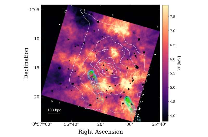
Temperature map of A119, overlaid with 1.4 GHz (green) and 150 MHz (blue) radio 
contours. The white contours are from the smoothed X-ray image. 
Credit: Watson et al., 2023.

Using NASA's Chandra spacecraft, astronomers have performed detailed X-ray observations of a complex galaxy cluster known as Abell 119. Results of the observational campaign, published August 9 on the pre-print ser

Galaxy clusters contain up to thousands of galaxies bound together by gravity. They are the largest known gravitationally bound structures in the universe, and could serve as excellent laboratories for studying galaxy evolution and cosmology.

At a redshift of 0.044, Abell 119 (or A119 for short) is a large galaxy cluster containing about 70 member galaxies. It hosts two narrow-angle tail (NAT) radio sources and its brightest cluster galaxy (BCG) is UGC 579. Previous observations have found that Abell 119 is a dynamically complex cluster with multiple substructures.

A group of  led by Courtney B. Watson of Boston University decided to investigate Abell 119 with Chandra in order to get more insights into its properties. The study was complemented by data from ground-based observatories.

The observational campaign of Abell 119 found that the overall X-ray emission from the  (ICM) is fairly asymmetric with an elongation to the northeast, resulting in a "teardrop" shape. Moreover, the adaptively smoothed X-ray image shows the possible presence of clumpy substructure within the ICM.

The astronomers identified two two  (CF1 and CF2) that could be connected to form a sloshing spiral structure, which may be a result of an off-axis . This sloshing spiral structure could correspond to the elongated teardrop-shaped X-ray emission seen in the northeast direction.

The observations detected a shock front located about 250 arcseconds from the cluster's core and just outside of the potential sloshing cold front. The shock has a Mach number of 1.21 and its velocity is estimated to be 1,530 km/s, what is consistent with a merger shock.

The study also found evidence of Abell 119's galaxies forming a filamentary structure which extends nearly 26 million  to the north-northeast direction, which appears to connect Abell 119 to another galaxy cluster—Abell 116.

Summing up the results, the authors of the paper underlined that Abell 119 is a fairly complex system, with a potential sloshing spiral, a merger shock, and possible connection with a neighboring cluster through large-scale filamentary structures. They added that their observations provide evidence of a recent or ongoing merger.

"Our results show alignment of the elongated X-ray emission, the optical substructures, and the flow directions of the radio jets/lobes of both NATs. This, with the comparison to simulations, all supports our picture of recent or on-going merger activity occurring in the NE-SW direction," the researchers concluded.ver arXiv, shed more light on the properties and nature of this cluster.

More information: Courtney B. Watson et al, Chandra X-Ray Observations of Abell 119: Cold Fronts And A Shock In An Evolved Off-Axis Merger, arXiv (2023). DOI: 10.48550/arxiv.2308.04367


Journal information: arXiv 


© 2023 Science X Network


Radio observations inspect galaxy cluster Abell 1413


Technology reveals new picture of ancient Native American culture

Technology reveals new picture of ancient Native American culture
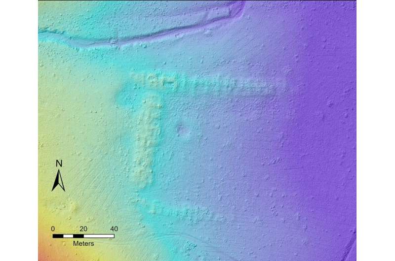
Data from drone-based lidar allows researchers to construct detailed images like this of the
 ground surface. In this image, the rooms of an ancient pueblo are visible, as well as a 
depression that researchers believe would have marked the location of a kiva inside the
 pueblo. 
Credit: Jeff Ferguson and Francisco “Paco” Gomez

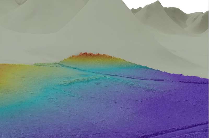
Jeff Ferguson, Rob Walker and Francisco "Paco" Gomez at the University of Missouri are part of an interdisciplinary research team using drones equipped with light detection and ranging, or lidar, to study ancient Native American villages called pueblos in the Lion Mountain area of western New Mexico. The team's goal is to better understand the connection between migration and social interaction patterns and pueblo occupations.

"Among the  discovered in the area is a massive pueblo likely built and occupied by immigrants from the large-scale abandonment of the Four Corners region, including Mesa Verde, in the late 13th century," said Ferguson, an associate professor in the Department of Anthropology.

"Our research is focused on documenting the regional settlement pattern and understanding how the migrants coming from the north interacted with existing local populations. Using this technology, we aim to efficiently identify any sites not previously documented."

Lidar is a technique that uses laser pulses to "map" the ground surface. While drone-based lidar can provide more detailed images of the  than plane-based lidar, the team is exploring whether drones can be used efficiently to conduct the large-scale land surveys needed to search for these sites—efforts that can sometimes encompass hundreds of square miles. After the sites are identified by air, they must be verified by researchers doing  on the ground through a process known as "ground-truthing."

"It's not always obvious that these features are architectural in nature," Ferguson said. "It could be difficult to distinguish between a natural rock outcrop or a cultural feature, so we must look at factors like alignment, positioning, size, type of rock and whether other cultural artifacts are present."

Sensitive to the cultural significance of these sites, the researchers are partnering with a cultural resource advisory team from the Pueblo of Zuni, one of several Native American groups who claim these ancestral sites as part of their cultural heritage. Ferguson described one such meeting last year after researchers discovered a small set of vertical stones placed in a box shape in the ground. The Zuni Cultural Resource Advisory Team (ZCRAT) determined it was a shrine and identified numerous others at additional sites. Researchers are planning additional fieldwork in partnership with ZCRAT in fall 2023.


Asking more in-depth questions

The use of drones to search for these sites has already opened the door for researchers to ask more in-depth questions about the migration patterns.

"We can look at a single migrant community and try to understand how that community integrated with local groups," Ferguson said. "We're using this information to ask questions like 'how are all these people interacting?" or 'what's the interaction between this likely migrant community and these local populations?'"

Obsidian sourcing

Another way for researchers to better understand how ancient Native Americans in the Lion Mountain area interacted within a broader social and economic network is by analyzing their use of obsidian, a stone used to make sharp tools for cutting and hunting.

"The chemical composition of the obsidian artifacts can be compared to known natural outcrops and help determine the geologic source of the artifacts," said Ferguson, who also teaches college students how to replicate stone tools. "The use of obsidian sourcing can be a good indicator of social and economic interaction in the past."

Technology reveals new picture of ancient Native American culture
Using data from drone-based lidar, this image shows the pueblo's "c-shaped" room block,
 along with the depression that researchers believe marked the location of a kiva. 
Credit: Jeff Ferguson and Francisco “Paco” Gomez / University of Missouri

In a recently published study in the Journal of Field Archaeology, Ferguson and colleagues detailed the use of a portable, handheld instrument called energy dispersive X-ray fluorescence spectrometry (ED-XRF), which allows them to analyze pieces of obsidian while in the field, eliminating the need for collecting these items for analysis in the laboratory.

"As we are ground-truthing, we identify all the obsidian in one area, then we pick each one up and run them in the instrument," Ferguson said. "Using this method, we can collect thousands of data points without having to actually collect any artifacts."

Involving artificial intelligence

Researchers like Ferguson and Walker, an associate professor in Department of Anthropology, are working to find a way to incorporate artificial intelligence and machine learning into this process.

Technology reveals new picture of ancient Native American culture
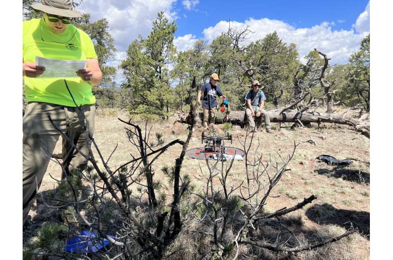
Researchers prepare a drone for conducting a large-scale land survey from the air. 
Credit: Jeff Ferguson

"The ultimate goal is to figure out how we can train machines to find these features even better and more efficiently than humans looking at the data," Ferguson said. "Once we know which areas have features or sites, we can train the model to say, 'this site is over here, now go and see what you can find through ground-truthing.'"

In addition to using the above applications to explore large-scale trade, researchers are developing plans to incorporate compositional analysis of pottery to better understand more local interactions between the area's individual communities. This research would involve analysis at the MU Archaeometry Laboratory at the MU Research Reactor (MURR).

More information: Jonathan M. Schaefer et al, In-Field Obsidian XRF Analysis of Sites in the Lion Mountain Area and Gallinas Mountains of West-Central New Mexico, Journal of Field Archaeology (2023). DOI: 10.1080/00934690.2023.2221520


Provided by University of Missouri At underwater site, research team finds 9,000-year-old stone artifacts


Research finds political attitudes did not change during COVID-19 pandemic

political rally
Credit: CC0 Public Domain

There is a traditional understanding that if someone experiences a threatening event, their attitudes and beliefs will change. Some scholars predict that a threat will cause someone to become more conservative on a variety of issues or that they will become more extreme in their attitudes.

However, a new study from researchers at Michigan State University and Tilburg University has found that Americans' political attitudes did not change significantly during the onset of the COVID-19 pandemic, contrary to what many expected. The study is published in the Personality and Social Psychology Bulletin journal.

"The onset of the pandemic was a major event that affected nearly every aspect of life. Political attitudes are often attitudes about how  should work and the rules and procedures that best guide society. One intuitive prediction is that if society changes, our political attitudes should also change," said Mark Brandt, a researcher and associate professor of psychology at MSU. "But that didn't happen. This suggests that people's attitudes are pretty resistant to changes, even when the conditions of society radically change."

With more than 2,000 people surveyed, the study is the most comprehensive analysis that has ever been conducted of attitude change in response to the COVID-19 pandemic, and possibly, to any major societal event. Data collected during the two different studies examined 84 different attitudes in all, including attitudes toward , unemployment benefits and trade with China. Researchers collected the data between spring of 2019 and the end of May 2020. To make visible day-to-day changes in attitudes across the timeframe, the team collected data weekly for one study and every other week for the second study.

Across the 84 attitudes, only 18 shifted in either the conservative or liberal direction—and these changes were small. For example, 3.5% of respondents did become more opposed to trade with China, while 11% of people became more supportive of , and 14% became supportive of economic stimulus.

"We hope that this study helps  understand how  respond to real-world events so they can make better predictions in the future," said Brandt. "We also hope that this information helps people recognize how difficult attitude change can be. Things like attitude and  do not seem to be the product of one large event, but instead, take time, effort and coordination among people from across society."

More information: Felicity M. Turner-Zwinkels et al, Ideology Strength Versus Party Identity Strength: Ideology Strength Is the Key Predictor of Attitude Stability, Personality and Social Psychology Bulletin (2023). DOI: 10.1177/01461672231189015


Water managers warn that stretches of the Rio Grande will dry up without more rain

Water managers warn that stretches of the Rio Grande will dry up without more rain
Sandbars are expanding in the Rio Grande as flows decrease through Albuquerque, N.M., 
on Thursday, Aug. 17, 2023. Water managers are warning than more stretches of the river 
near New Mexico's largest city are expected to go dry without more rain.
 Credit: AP Photo/Susan Montoya Bryan

The ongoing lack of rain and hot conditions have left one of North America's longest rivers in dire shape again, prompting water managers on Thursday to warn farmers in central New Mexico who depend on the Rio Grande that supplies will be drying up in the coming weeks.

That means stretches of the river through the Albuquerque area are expected to go dry—much like last year.

Water managers and fish biologists at the Middle Rio Grande Conservancy District and the Bureau of Reclamation say they're working to mitigate the effects on the endangered silvery minnow—a shimmery, pinky-sized native fish.

Water users in the Middle Rio Grande have been given notice to anticipate changes in availability and delivery schedules soon.

Due to a higher-than-normal irrigation demand and lower than expected natural river flow, the conservancy district began releasing  on July 17 from the San Juan-Chama Project, which brings water from the Colorado River Basin into the Rio Grande Basin via a system of diversion dams, tunnels, channels and other infrastructure. About 40% of the current irrigation supply is from project storage releases, with the rest from natural river .

Irrigation district officials expect water from the project to run out before Aug. 23, leaving them to rely solely on natural flows to continue making water deliveries through the fall.

"The lack of rainfall is difficult on its own, coupled with the challenges of not being able to store water for summer releases, is disheartening, but we are doing our best to work with water users in the middle Rio Grande Valley to deliver what is available," Jason Casuga, the irrigation district's chief executive, said in a statement.

The Bureau of Reclamation will release water to supplement flows in cooperation with the  district and the U.S. Fish and Wildlife Service to target specific areas of the river with known silvery minnow habitat and to manage the rate of anticipated river drying.

The Rio Grande went dry in Albuquerque for the first time in four decades in August 2022 due to persistent drought.

Over the past 20 years, the Bureau of Reclamation has leased about 700,000 acre-feet—or 228 billion gallons—of water to supplement flows through the Middle Rio Grande for endangered and threatened species.

The silvery minnow has been listed as endangered since 1994. It inhabits only about 7% of its historic range and has withstood a century of habitat loss as the nearly 1,900 mile-long (3,058-kilometer) river was dammed, diverted and channeled from Colorado to New Mexico, Texas and northern Mexico.

© 2023 The Associated Press. All rights reserved. This material may not be published, broadcast, rewritten or redistributed without permission.


A race to save fish as Rio Grande dries, even in Albuquerque

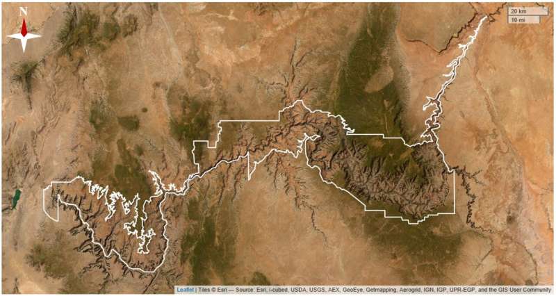
Models suggest Grand Canyon could see increase in heat-related illnesses due to climate changeModels suggest Grand Canyon could see increase in heat related illnesses due to climate change

Map of the study site with Grand Canyon National Park boundaries depicted in white. Park 
boundary data are publicly available through NPS IRMA and base map data is publicly 
available. Credit: PLOS ONE (2023). DOI: 10.1371/journal.pone.0288812

A pair of resource stewardship researchers at the U.S. National Park Service's, Natural Resource Stewardship and Science Directorate, working with a colleague from the University of Pennsylvania, has found via modeling that it is likely more visitors to Grand Canyon National Park will experience heat-related injuries as the region warms due to climate change.

In their study, reported in PLOS ONE, Danielle Buttke, Gregor Schuurman and Brinkley Raynor used data from a variety of sources to predict the increase in heat-related illness in the coming years.

Grand Canyon National Park is one of the most visited parks in the U.S. despite its reputation as an extremely hot region. Temperatures at the bottom of the canyon average near 60°C (140°F) during the  and can be even hotter on trails leading down because the dark-colored walls absorb heat.

Such temperatures can lead to heat-related illnesses if visitors are not properly prepared—approximately 77 cases of such illness, on average, are reported at the park each year.

In this new effort, the researchers note that as temperatures rise in the area in the coming decades, it is likely that an increasing number of people will experience one or more heat-related symptoms, such as light-headedness, nausea, vomiting, , and in some cases, death.

To predict such an increase, the research team used  to predict temperature and humidity increases at the park. They then used statistical models to make predictions about the number of people likely to visit the park in the coming years. Combining the two models allowed them to make predictions about how many people may be at risk of heat-related illnesses up to the end of this century under two scenarios—one where temperatures increase by 3°C and the other where it increases by 5°C.

The team found that unless restrictions are put in place at the park, heat-related illnesses are likely to rise. Under the , they found that the number of people experiencing such illnesses could rise to between 138 and 254 each year.

More information: Danielle E. Buttke et al, Predicting climate-change induced heat-related illness risk in Grand Canyon National Park visitors, PLOS ONE (2023). DOI: 10.1371/journal.pone.0288812


Journal information: PLoS ONE 


© 2023 Science X NetworkIn the summer heat, know how to recognize—and prevent—heat stroke


Greenpeace slams Poland's new river protection law

Polish firefighters set up a floating dam to catch dead fish from the river Oder in August 2022
Polish firefighters set up a floating dam to catch dead fish from the river Oder in
 August 2022.

Environmentalists on Friday slammed the passing of a controversial law in Poland on the revitalization of the Oder river, which was hit by toxic algae growth last year that caused mass fish deaths.

A toxic algae bloom hit the river on the Polish border with Germany last summer, with at least 300 tons of dead fish pulled from the  as tensions spiked between the two countries.

In response to the environmental disaster, Warsaw passed a new law Thursday evening which includes provision for new water treatment plants, and is intended to put more stringent requirements on industrial sites.

But Greenpeace said the government had "ignored the voice of the public and scientists" in passing the law, in a statement on the social media site X, formerly known as Twitter.

They criticized what they said was a lack of consultation and said that the bill will "not protect the Oder" and will continue to be polluted.

The World Wildlife Fund (WWF) had previously criticized the bill for focusing on "further regulation of the Oder (and other rivers), which will further destroy the ecosystem and its ability to clean itself."

The law allows the building of new infrastructure including the modernisation of sewer systems and constructing new water treatment plants, estimated to cost some 9.5 billion zlotys ($2.3 billion).

The new law also forces large industrial sites, such as mines, to invest in systems to reduce saltwater discharges.

The toxic algae growth was sparked by the introduction of high levels of salt into the waters, according to the German environment ministry, which said that there was a "lack of available information" on the cause.

Poland also blamed  for the mass fish deaths, but said the disaster had most likely been caused by  as a result of high temperatures and very low water levels.

Polish and German authorities on either side of the river have said they are determined to stop future disasters happening, but have clashed over responsibility and the best way to keep the algae in check.

© 2023 AFP


Germany says mass fish deaths in Oder river a 'man-made disaster'