Friday, August 18, 2023


Creating a disaster preparedness plan for your pets

animal shelter
Credit: Pixabay/CC0 Public Domain

Recently, Texas Gov. Greg Abbott announced a wildfire disaster declaration for about 75% of the state's counties and the National Oceanic and Atmospheric Administration also released an updated hurricane season outlook that includes a 70% chance of 14-21 named storms before the season ends in November.

With these potential weather threats in mind, now is a good time to consider what you might do with your pets if there was an emergency.

Having a plan in place is crucial for the furry members of your family. The most important way for  to prepare for a disaster evacuation is to plan ahead and pack a go-kit, an easy-to-grab, waterproof bag or container with basic survival items and supplies.

Planning ahead

The first step in planning ahead is to know where you are going in the event of a possible evacuation by compiling a list of hotels, boarding facilities, and shelters that allow pets.

"This helps you know where you can go, depending on the types of animals you have and how many, and can give you a leg up on calling them quickly when you know you will be evacuating and need a reservation," said Dr. Deb Zoran, a professor at the Texas A&M School of Veterinary Medicine and Biomedical Sciences.

"Before you need them, be sure you have information on the hotel, shelter or boarding facilities you may use when a disaster is headed your way, check that they have a good reputation for their animal care, and make sure the facilities are completely out of harm's way."

While gathering information, owners can also confirm if the facilities require specific vaccinations.

"The only vaccine that is required by law in most places is rabies, yet even that vaccine is not always required for entry into an emergency animal shelter," Zoran said. "A majority of animals brought to a shelter after being rescued from a flood, fire or tornado come without their owners—or their owners come with them but without documentation. Emergency shelters have to operate on this premise."

To ensure there is no doubt about a pet's vaccination status, owners should keep records of vaccinations that evacuation shelters may require evidence of, including:

  • Rabies
  • DA2PP, a single vaccination for distemper, adenovirus type 2, parvovirus, and parainfluenza
  • kennel cough for dogs
  • FVRCP, or feline viral rhinotracheitis, calicivirus and panleukopenia

"Most shelters allow non-vaccinated animals into the shelter but separate the animals with vaccination papers from those without," Zoran continued. "Ultimately, you need to consult with your vet about appropriate vaccines for your dog or cat."

Assembling a go-kit

Owners should ask their veterinarian annually for copies of vaccine records and medication details to print and include with their go-kit.

"If your pet needs medications—heartworm, flea prevention, or specific medication for  such as thyroid or heart medicine, antibiotics, etc.—you need a copy of the medical records showing that your pet requires this medication should you not have enough or the medication is lost and has to be refilled," Zoran explained. "Pet medications cannot be given to you without documentation or a new vet exam, so having records available is important."

A go-kit should also include first aid supplies; cleaning supplies, including pet waste bags and sanitizing wipes; and feline supplies, if applicable, such as a litter box, scooper and litter.

Zoran suggests owners pack additional items that can help keep pets safe and comfortable while traveling and throughout their stay in an unfamiliar place.

"Disasters are a stressful time for pets, so bringing things that smell familiar, special treats, normal food, and toys is very important," Zoran said. "Cats, in particular, not only need the kennel that they travel in, but if they are going to be away from home for days or weeks, they will need a kennel at least 2 feet by 3 feet or larger to live in; they need room to sleep, a box to hide in and a place for the litter tray."

Normal foods that pets are accustomed to contribute to keeping pets healthy during difficult situations.

"Familiar foods and  will help prevent gastrointestinal upset, as sudden food changes in the shelter environment can lead to loss of appetite, vomiting or diarrhea, adding to the stress of the moment," Zoran said. "Cats will be less willing to eat in a stressful or busy environment if they don't have their own food and if they don't have a quiet place or time to eat."

Disaster evacuations can create stressful environments for people and pets alike, but adding identification tools and transportation supplies into a go-kit can help prevent pets' needs from being overlooked in the chaos.

"Both dogs and cats need to have microchips, collars or harnesses for identity protection and escape prevention," Zoran explained. "Cats should not be removed from kennels without a harness on, as fear-inducing experiences can cause them to run and hide. Dogs, even the most highly trained ones, will also flee, so careful use of collars and leashes is essential, both for their protection and for preventing interactions with other animals at the emergency ."

More information: Pet owners should familiarize themselves with additional preparation tips by Texas A&M University's Veterinary Emergency Team to establish a plan, ahead of an emergency situation.


Provided by Texas A&M University Know the requirements for your pet's rabies vaccination
 

Q&A: Urban doom loop—what it is and how cities can stop it

Q&A: Urban doom loop: What it is and how cities can stop it
Credit: Tufts University

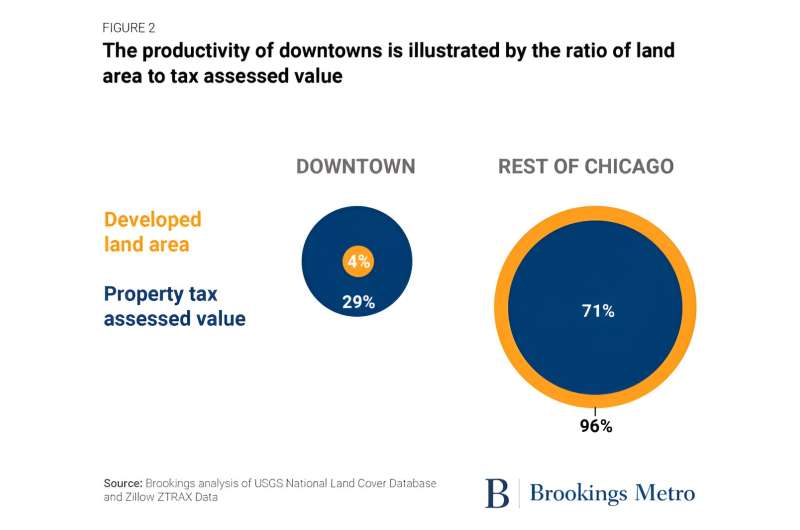
Recent images of downtown San Francisco—emptied of office workers now dialing in remote and filled with wandering homeless people—has struck fear for the future of urban areas. A Columbia University professor coined the term "urban doom loop" for the downward spiral some cites seem to be on, as workers don't return, retail businesses shutter for lack of customers, residents flee to the suburbs, and city tax revenues decline, leading to fewer services, and then fewer residents.

Stories like those about failing urban centers are "filling some urban observers with existential dread," according to a recent Brookings Institution report.

"While the notion of the urban doom loop makes good headlines, I don't see it as something beyond our control," says Jon Witten, a senior distinguished lecturer in the Department of Urban and Environmental Planning and Policy (UEP) who has taught at Tufts for 36 years. "We're not a leaf in the wind here. Cities, towns, and regions control the narrative; they just need to do so."

Tufts Now spoke with Witten, a land use planner and lawyer, to learn more about the state of American cities, including Boston, and what they need to do thrive.

Tufts Now: In the 2000 to 2020 period, a number of cities across the country grew and became magnets for people moving into urban areas. What made those cities grow like that?

Jon Witten: There were a number of reasons, but a big one was the demand for high-end housing from young professionals moving into cities, because that's where the jobs were. But post-COVID-19, cities began to falter—much like we saw in the 1960s and 1970s—and people, at least for now, are clearly leaving cities, citing the availability of remote work and a general sense that congregating hundreds of people in a downtown office skyscraper may no longer be a workable model.

The question now is, where are these folks going and how do cities survive without them? That's where this kind of pejorative statement of urban doom loop comes in.

Are people moving to the suburbs? And if so, what are the consequences of that for cities?

In many parts of the country there has been a shift back to the exurbs and the suburbs, coupled with federal and state disinvestment in  like we saw in the late 1960s and 1970s. That retrenchment evoked the infamous 1975 New York Daily News headline "Ford to City: Drop Dead."

While I don't see ongoing events being that dramatic—many cities appear to be recovering post-COVID—the definition of the urban doom loop presumes that as more residents leave the city and less development occurs, the revenue stream—the property tax—diminishes, often rapidly. The doom is the loss of revenue, and the loop is the vicious cycle that becomes difficult to stop.

From a  and municipal governance lens, it becomes a self-fulfilling prophecy. New residents—taxpayers—resist moving to the city as governmental services are diminished or disappear—the  aren't sufficiently funded, public playgrounds and  aren't maintained, and so on—and yet the very revenue needed to make the city attractive again is simply not available.

What other challenging issues do cities face?

Every city and town has been negatively affected by COVID, but in some cases, COVID sadly highlighted just how bad things were prior to 2020. Public transportation provides a telling example. Before COVID, for example, getting from the suburbs to the urban downtown was a challenge in most cities in the country. We've historically ignored this simple question: If I'm living in the suburbs, how do I get to the city for work?

Putting aside many urban planning stereotypes that cities are good and suburbs are sterile and bad, if commuters trying to get to work in the city can't reasonably do so, at some point they will stop trying. That is the real urban doom loop.

That isn't caused by public health crises, but rather by the lack of political courage and investment to tether the city to where people want to—or have to—live.

Boston has been on a loop of doom for decades, not because of COVID or some external force beyond the state's control, but rather because the state refuses to think regionally and recognize that for Boston to thrive, the suburbs and remaining rural portions of the state must do so, too.

Is that true of many American cities?

It is. Los Angeles, of course, is the king. New York comes a close second, but every major U.S. city has suffered from the disinvestment, or lack of initial investment, in public transportation, such that getting from the suburbs to downtown, and vice versa, is only slightly better than intolerable.

In Washington, D.C., the metro system extends farther and farther out as the suburbs expand into Maryland and Virginia—is that better?

No, that's just as bad and shortsighted. Where's the plan, what's the goal, and where's the courage to say that not every square foot of a region needs to be paved over and accessible to developers?

The D.C. approach has set a dangerous precedent for urban transportation in the U.S. Fueling land development and unfettered speculation by laying out more and more rail lines without first having a plan to ensure that impacted cities, towns, and regions are prepared for what will follow is irresponsible.

Are there urban centers where the cities have emptied out and the suburbs now are the economic centers?

Yes, and that's not uncommon, especially with mid-size cities such as Cleveland and other "rust belt" cities, where the center city has really struggled since the 1960s and 1970s. But in many of these cities, and Cleveland is a good example, the impacts to the center city were often mitigated by investment—public transportation and otherwise—to create what was labeled as an "edge city."

These areas, often within the historic city limits or close to it, provide a tethering of suburbs and the urban core. Edge cities aren't without problems; the land they're developed on was the suburban fringe or rural countryside, and are now the site of office parks and retail shopping malls.

So I'm not championing this idea at all, only recognizing that the decline of urban centers, whether historic or due to a post-COVID doom loop, has historically led to alternative patterns of employment, housing, and related development and revenue-raising approaches.

I've read that one solution to empty office towers is to turn commercial real estate in downtown areas into housing. Would that help?

Converting office to residential space is certainly a good idea in isolated instances, but once again the doom loop concern is triggered. If we're losing office space, then we're losing employment. Building more housing will satisfy developers, speculators, and bankers, and those who argue that all we need to do to fix our housing problem is build more housing.

But housing for who? Retirees? Maybe, but I don't think so. It's a marketing ploy—because where are people going to work? Not in downtown anymore.

Can urban planners help with job creation in cities?

As a planner and one who's had the honor of teaching at UEP for the past three plus decades, I'd be the first to say that urban planners can offer a lot of good advice and technical expertise, but at the end of the day, land-use decisions are political decisions. If state and local political leaders have the courage to think forward—plan—the answer is yes.

If, on the other hand, political leaders respond to the issue du jour—today "badly needed affordable housing," tomorrow "badly needed jobs," and thereafter "badly needed something else"—I think the answer is no.

Urban planning must be comprehensive, inclusive, and holistic. To avoid a doom loop, state and local leaders need to accept the reality that urban planning and urban governance is complicated and requires comprehensive thinking. Trying to address Boston's or New York's housing shortage or transportation woes isn't an isolated task solved by simply building more housing or more roads or expanding rail lines.

What do you think Boston can do to try to avoid the doom loop?

I suspect Boston will survive the ebbs and flows of post-COVID impacts given the city's history—we've had bigger troubles before this one—and the large presence of nonprofit and governmental agencies that provide a reasonably secure employment base not tied to a particular industry or service.

I think the question isn't so much about Boston's future as it is the region's. If train service is nonexistent or dysfunctional, if the state remains beholden to the real estate industry, and if the agenda is not being set by comprehensive statewide, regional, and urban plans, then I think we are in big trouble.

Cities and towns aren't like leaves in the wind, helpless against the forces of nature. We are totally capable of creating and making good use of comprehensive plans. But that requires political courage that we haven't seen in Massachusetts. This remains one of the few urbanized states that has rejected comprehensive land-use planning and substituted in its place an endless whiplash of crises, many real, but also many exaggerated by those who profit from them.

What do you see as the future of downtowns? Is it potentially optimistic?

I'll stop teaching the minute I think there's no reason for optimism. We put ourselves in this predicament and we can get ourselves out of it. Urban planning dates back literally thousands of years.

Some plans have obviously failed, badly, but many others are inspirational and models for how society can function collectively and equitably. It's a never-completed task, of course, but the effort is worth it, and not only because the alternative is so much worse.

The alternative is that cities and towns do nothing and simply let the free market—the development and real estate industry—dictate the future of our old and new urban centers. Such an outcome may be supported by some economists espousing laissez-faire principles, but when it comes to rational decisions regarding limited land and natural resources, I think it hopelessly naïve and shortsighted.

More information: Report: www.brookings.edu/articles/bre … s-shared-prosperity/


Provided by Tufts University Longer commutes affect the cost of living in large cities more than zoning restrictions


Nauseous territory: Outfoxing predators using baits that make them ill

red fox
Credit: Pixabay/CC0 Public Domain

Introduced foxes, dogs, cats, rats, and other predators kill millions of native animals every year, but what if they were conditioned to associate this prey with food that made them ill

A team of international researchers have shown the potential to do just that, burying baits containing capsules of levamisole, a chemical that induces nausea and vomiting when consumed by predators.

In a world first experiment conducted in south-eastern Australia, where introduced  are responsible for countless wildlife deaths, the Australian National University (ANU) and University of South Australia scientists laid baits of fried deboned chicken, with some containing encapsulated levamisole to hide the taste and smell of the chemical that makes animals nauseous or sick.

Over three sequential periods, untreated baits were laid, followed by levamisole-containing baits and untreated baits again. During the final period baits taken fell by 30%, indicating that foxes had consumed the levamisole-containing baits, fallen ill, and were reluctant to go back for seconds, despite the later absence of levamisole.

Researchers say this evidence shows it is possible to condition  to avoid  based on their unique odor, and ultimately this strategy may be applicable to protecting vulnerable wildlife living in that habitat.

The non-lethal tactic for keeping predators at bay could be potentially more effective than shooting, trapping and poison baiting in certain contexts, according to ANU Ph.D. student Tim Andrewartha.

"Based on our findings, this potential is something we hope to explore in the future," Andrewartha says.

UniSA researcher Associate Professor Anton Blencowe says invasive predators are responsible for almost 60% of all bird, mammal, and reptile extinctions globally, so it's critical to find ways to mitigate their impacts on .

"Existing lethal control methods—shooting, trapping, and poisoning can be counterproductive in some situations, with  capable of adapting their behavior and becoming harder to control," he says.

The tactic employed in this experiment, known as conditioned taste aversion (CTA), shows promise as a tool to reduce the predation of vulnerable wildlife, the researchers outline in a paper published in Conservation Science and Practice, titled "Landscapes of nausea: Successful conditioned taste aversion in a wild red fox population."

A range of encapsulated nausea-inducing agents can be injected into food sources, such as eggs or animal carcasses, so the predator associates the symptoms with the food odor and not the chemical.

Microencapsulation, where the agent particles are minimized, can also be used to hide textures and prevent the capsule from being accidentally broken open during consumption.

Scientists say more research is needed to determine the best chemical and dosage used, whether live prey rather than a carcass are more effective at conditioning aversion in the red fox, and the time between consumption and onset of symptoms.

The study was led by the Australian National University in collaboration with the University of South Australia, the University of Tokyo, and James Hutton Institute, UK.

More information: Tim Andrewartha et al, Landscapes of nausea: Successful conditioned taste aversion in a wild red fox population, Conservation Science and Practice (2023). DOI: 10.1111/csp2.12984


Provided by University of South Australia Endangered birds can be protected from predators with chemical camouflage

Invasive firestarter: How non-native grasses turned Hawaii into a tinderbox

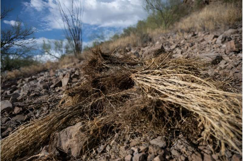
Dried buffelgrass, an invasive species that leads to faster growing wildfires, is seen on the side of a hill near a trail in Tuc
Dried buffelgrass, an invasive species that leads to faster growing wildfires, is seen on the 
side of a hill near a trail in Tucson, Arizona.

After a catastrophic wildfire that killed more than 100 people in Hawaii, eyes have turned toward an unexpected culprit: invasive grass species that have spread massively over the archipelago for decades, serving as the perfect fuel.

Drought-resistant, capable of invading difficult terrain, and gradually muscling out , they are also a growing threat in the western United States, where devastating fires are increasing.

"Invasive grasses are very ignitable. They change the landscape," Carla D'Antonio, a professor of ecology at the University of California, Santa Barbara told AFP.

"They make conditions that are more conducive to more fire, and all of a sudden, we just have a lot more fire."

Rather than decomposing when they die, they stay "standing there for a long time, dry as a bone," said D'Antonio, who has been studying these species for more than 30 years. They're also hardy, surviving fires better than  and gradually replacing them.

Most of these grasses—buffelgrass, Guinea grass, molasses grass—came from Africa, and were introduced as pasture for cattle, without knowing the danger they would come to represent decades later.

In Hawaii, the demise of sugar cane plantations in the 1990s as a result of globalization had disastrous consequences: huge tracts of land were abandoned, allowing the invasive species an opening.

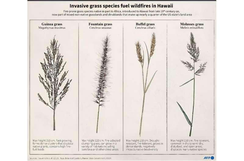
Invasive grass species fuel wildfires in Hawaii
Graphic showing a selection of invasive and flammable grass species in Hawaii that can
 act as fuels for wildfires.

"Yes, many parts of Hawaii are trending towards dryer conditions, but the fire problem is mostly attributable to the vast extents of non-native grasslands left unmanaged by large landowners as we've entered a 'post-plantation era,'" said Clay Trauernicht, a fire ecologist at the University of Hawaii at Manoa.

Trauernicht said the annual area burned in Hawaii has increased by 300 percent in recent decades.

A 2021 fire prevention report by Maui County described fires as a growing threat due to increasing temperatures and prolonged periods of drought as a result of climate change, and the growing menace of intrusive grasses.

Hawaii, despite its tropical reputation, is getting drier: a 2016 study found 90 percent of the state received less rain compared to a century earlier.

The Maui County report recommended "an aggressive plan to replace these hazardous fuel sources with native plants to reduce combustible fuel while increasing water retention."

This undated handout photo provided by Carla D'Antonio shows invasive molasses grass (Melinis minutiflora) filling in spaces bet
This undated handout photo provided by Carla D'Antonio shows invasive molasses grass 
(Melinis minutiflora) filling in spaces between remnant native shrubs and trees in burned 
areas of Hawaii Volcanoes National Park.

'Nothing natural about it'

The problem isn't confined to Hawaii. Over in the mainland United States, "the deserts of the West and the conifer forests, and then the shrub lands in the  are here to stay, they're now part of the ecosystem," said D'Antonio.

She herself spends some Saturday evenings weeding roadsides with neighbors in a mountainous area near Santa Barbara, California. Their goal: to prevent a fire from starting from a cigarette butt or an overheating vehicle.

Most of the major fires of the Mojave and Great Basin have been fueled by invasive grasses, she says, while also citing the Camp Fire of 2018, which destroyed the small California town of Paradise, killing more than 80 people. It was started by a power line igniting dry grass.

"(I'm) not making the mistake of calling it a natural disaster because there's almost nothing natural about it," emphasizes the scientist.

One of the invaders, buffelgrass, also threatens the emblematic cactus of the Saguaro National Park in Arizona, by smothering young saguaros and fueling fires in the region. Organizations regularly organize clearing operations. The same species is spreading in Mexico and in Australia.

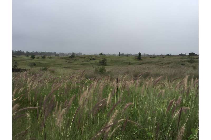
This undated handout photo provided by Carla D'Antonio shows fountain grass (cenchrus setaceum) covering large areas of the kona
This undated handout photo provided by Carla D'Antonio shows fountain grass (cenchrus
 setaceum) covering large areas of the kona side of Hawai'i island.

According to a 2019 study, six invasive  species caused fire frequency to increase by up to 150 percent in US ecosystems.

For D'Antonio of UC Santa Barbara, tragedies like that of Hawaii are linked to many factors: the alteration of the landscape by humans, the invasion of alien , droughts made worse by climate change, but also a lack of preparation.

In the American West, widespread logging of conifer forests in the 19th century and a long history of excessive fire suppression in the 20th century contributed to accumulation of tinder on the forest floor.

"The potential for disaster is huge," said D'Antonio, leaving society with daunting questions to address. "How do we plan for the extreme? Not for the average fire, but the extreme ?"

© 2023 AFP


Rising non-native cover in the Santa Monica Mountains threatens native biodiversity and increases fire risk


Study shows that wildfires once fueled extinctions in Southern California; will it happen again?

Study shows that wildfires once fueled extinctions in Southern California; will it happen again?
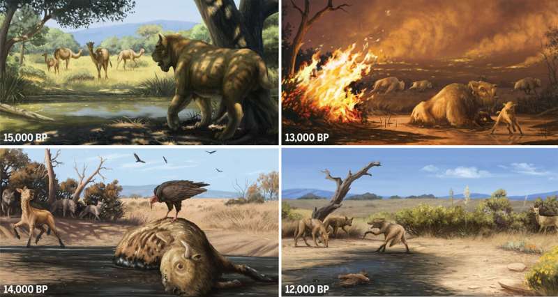
Sequence of ecological events as recorded at Rancho La Brea, California
Top left: conditions around the tar pits were moist and cool, with abundant trees and 
megafaunal mammals. Bottom left: the onset of postglacial warming and drying begins as 
human pressure on herbivores increases. Top right: the synergy between climatic and 
human impacts enables a sudden ecological state transition characterized by
 unprecedented fire activity. Bottom right: a chapparal ecosystem is established; 
megafauna are extinct, and only coyote entrapment continues at the tar pits.
 Credit: C. Townsend / The Natural History Museums Of Los Angeles County

Tens of thousands of years ago, before the last ice age ended, vast herds of saber-toothed cats, giant sloths, American camels and other fantastic beasts roamed Southern California.

Then they were gone. The culprit behind their disappearance has never been identified.

Scientists have floated theories over the decades—a dearth of prey for carnivores, overhunting by rapacious humans—yet none has fully explained why the ecosystem here changed so dramatically at the end of the Pleistocene epoch, some 13,000 years ago.

In a major new study, researchers used tangles of bones from the La Brea Tar Pits, ancient mud from the bottom of Lake Elsinore and an array of other evidence to piece together the region's archaeological record. The results, published Thursday in the journal Science, paint an astonishingly detailed picture of the events that led to the animals' disappearance.

The findings are startling, both for the clarity of the evidence and for their disturbing similarities to today's ecological crisis.

The authors concluded that the magnificent mammals of the Ice Age vanished with shocking speed when a period of warm, dry climate conditions coincided with the arrival of humans and a tool they struggled to contain: fire.

Even with only a tiny fraction of today's population and infinitely less powerful tools, it took the area's earliest human inhabitants less than 200 years to utterly transform Southern California's landscape. Fires they started but could not control led to the swift demise of species that had ruled the land for millennia, and fundamentally reshaped the ecosystem from a prehistoric woodland to the chaparral we recognize today.

Emily Lindsey, a curator at the La Brea Tar Pits and the study's senior author, said the take-home message is clear.

"Humans were responsible for these fires, and the fires coincide exactly with the complete disappearance of megafauna from the environment," she said. "They go away and they never come back."

Scientists who were not involved in the research said it offers the most complete picture yet of California's first human-driven ecological catastrophe, and offers valuable insights into where our current one may be heading.

"This paper provides a picture of how climate change can completely transform ecosystems," said Jarmila Pittermann, a plant physiologist at UC Santa Cruz who researches extinction. "It is super-convincing and a massive warning to all of us."

The study began with an effort to use radiocarbon dating to determine the ages of a few hundred of the approximately 3.5 million bones unearthed over the years from the La Brea Tar Pits. Unlike other methods of fossilization in which organic matter is replaced over time by sediment, tar preserves a bone's collagen, which is more conducive to getting a precise radiocarbon date.

The nature of the tar pits makes it easy to determine which animals died there, but harder to know when they died. Many pits were active over thousands of years, entrapping countless animals whose remains muddled together.

Each bone in the mid-Wilshire museum's collection is tagged with the date and pit number where it was found. As the researchers started working through fossils extracted from Pit 61/67, they made a surprising discovery: The pit had been active during the years of the mass extinction.

Specimens older than 13,000 years came from a variety of animals once common in Southern California: saber-toothed cats, dire wolves, western horses, bison, coyotes.

But after the 13,000-year mark, that diversity disappeared, said Regan Dunn, a curator at the tar pits and co-author on the study. The only big mammal bones found in the pit from that point on were from coyotes, ancestors of the wily canines still roaming the hills today. ("They're survivors. They can adapt to different environments," Dunn explained.)

The tar pits provide a remarkably complete cross-section of life at the time, preserving birds, small reptiles, insects, plants and even pollen that fell into the muck along with larger mammals. Unfortunately, it wasn't until the late 1960s that scientists recognized the value of this bounty and began to preserve these nonmammal fossils during excavations.

So to figure out what was going on in the environment at that time, Lindsey and Dunn had to look elsewhere: the bottom of Lake Elsinore.

One of Southern California's few freshwater lakes, Lake Elsinore's bed is made up of thousands of layers of ancient sediment that have piled up on each other like pages in a history book, said Matthew Kirby, a paleoclimatologist at Cal State Fullerton who worked on the study.

Over the last two decades, Kirby's team has collected about 100 vertical feet of mud from the lake bottom that accumulated over roughly 33,000 years. The pollen in that mud tells us what plant life was prevalent in particular years. Larger grains of sand indicate a season of heavy rainfall that washed more soil into the lake, while layers with higher salt counts suggest drier, hotter weather.

"It's really amazing what you can find in mud," Kirby said.

The Lake Elsinore data Kirby and others had published over the years attracted scientists eager to understand the mystery of California's former climate. One of them was Lisa N. Martinez, a UCLA student who became interested in the specks of charcoal that showed up in the lake bed's mud samples.

She wrote her 2020 master's thesis on evidence of fire activity entombed in the mud. It grabbed Lindsey and Dunn's attention as they combed through climate research about that pivotal time in Southern California's history.

Prior to 13,200 years ago, the mud cores show minimal fire activity, Martinez found. But then "we see unprecedented fire activity," said Martinez, now a doctoral candidate in geography at UCLA and a co-author of the study. "The charcoal abundance increases by an order of magnitude, and then it remains high for the next few hundred years."

The researchers could then assemble a picture of ecological collapse that happened gradually, and then all at once.

Worldwide, the period from 14,000 years ago to 13,000 years ago was unusually warm and dry. Air temperatures in Southern California rose an average of 5.6 degrees Celsius (10 degrees Fahrenheit). Vegetation grew incrementally drier.

Unlike today's warming, which is largely driven by greenhouse gases generated by human activity, this long warming phase was a natural phenomenon, one of several climate oscillations in the late ice age.

Yet by the end of this long warming cycle, there was a new variable on the scene that hadn't been present during previous dry stretches: humans.

The oldest human remains yet discovered in North America were found on the Channel Islands off the coast of Santa Barbara, and date back 13,000 years. Researchers suspect their populations were small, with large mammals still outnumbering their human neighbors by as much as 100 to 1, Lindsey said.

Yet even modest numbers of humans literally burned their way into history. As soon as humans arrive on the scene, "suddenly, there's tons of fire in the record," Lindsey said.

These massive fires changed everything, the researchers argue. While their sources of ignition were quite different from the power lines and exhaust pipes that tend to spark fires today, our Pleistocene ancestors had few tools at their disposal to extinguish a blaze once it spread out of control.

Once-abundant junipers and oaks could tolerate drought, but had no defenses against fire. They disappeared, and fire-adapted pines and chaparral took their place. In a landscape stripped of shade, shelter and hiding places, food chains were upended. Intense fire may have altered water flows or cut off migration routes.

According to the fossil record, all of this devastation took barely 200 years.

"This is the most significant extinction since a meteor slammed into Earth and wiped out all the big dinosaurs. It's probably the first pulse of the extinction crisis that we're in today," Lindsey said.

The study's authors noted the unsettling similarities between the late Pleistocene extinction and present-day climate conditions in the American West: higher temperatures, drier vegetation and a growing human population that can't stop itself from setting things ablaze.

The events of 13,000 years ago show "what humans can do on even a small scale. Now magnify that by many orders of magnitude and this story is to some degree a vision of what our future may look like," Kirby said. "Humans are impacting the climate, they're impacting the ecology, they're impacting the fire regime just like we saw in the past—but in a much, much more significant way."

The starkest difference between then and now is that today, all of the factors that led to the  of the ice age mammals are bigger, faster or stronger.

We have more people, and more ways to spark fires beyond the humble campsite or lit torch.

The climate is heating up at an exponentially higher rate. In the late Pleistocene, it took 1,000 years for temperatures to rise 5.6 degrees C. In the Anthropocene, temperatures in California have risen nearly 2 degrees C in the last 100 years alone.

It's not hard to imagine many species today shortly going the way of the saber-toothed cat.

"This study is a great example of how we can use the past to portend the future," said Anthony Barnosky, a paleoecologist and emeritus professor at UC Berkeley who was not involved in the research. "What we are seeing today—increasing human pressures combined with and actually causing —is like this lesson from the past on steroids."

More information: F. Robin O'Keefe, Pre-Younger Dryas megafaunal extirpation at Rancho La Brea linked to fire-driven state shift, Science (2023). DOI: 10.1126/science.abo3594www.science.org/doi/10.1126/science.abo3594


Journal information: Science 


2023 Los Angeles Times. Distributed by Tribune Content Agency, LLC.

Rampant wildfires once led to global mass extinction, scientists say. Can it happen again?


NASA's lunar trailblazer gets final payload for moon water hunt

NASA’s Lunar Trailblazer Gets Final Payload for Moon Water Hunt
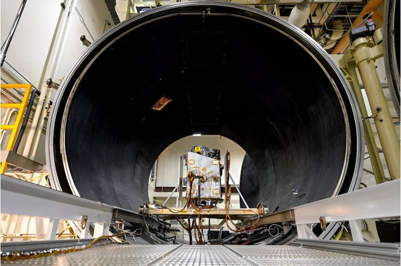
NASA’s Lunar Trailblazer is shown here during thermal vacuum chamber (TVAC) testing at 
Lockheed Martin Space in Littleton, Colorado, in June 2023.
 Credit: Lockheed Martin Space

NASA's Lunar Trailblazer is nearing completion now that its second and final cutting-edge science instrument has been added to the small spacecraft. Built by the University of Oxford in England and contributed by the UK Space Agency, the Lunar Thermal Mapper (LTM) joins the High-resolution Volatiles and Minerals Moon Mapper (HVM3), which was integrated with the spacecraft late last year. Together, the instruments will enable scientists to determine the abundance, location, and form of the moon's water.

Led by Caltech in Pasadena, California, Lunar Trailblazer has a mass of about 440 pounds (200 kilograms) and measures only 11.5 feet (3.5 meters) wide with its solar panels fully deployed. The small satellite will rely on the LTM instrument to gather temperature data that will reveal the thermal properties of the lunar surface and the composition of silicate rocks and soils. The HVM3 imaging spectrometer, which was built by NASA's Jet Propulsion Laboratory in Southern California, will detect and map the form, abundance, and locations of water in the same regions as the LTM instrument.

"Lunar exploration is an international endeavor, and Lunar Trailblazer embodies that spirit with the University of Oxford's and UK Space Agency's contribution to the mission," said Bethany Ehlmann, the mission's principal investigator at Caltech. "With the combined power of both of these sophisticated instruments, we can better understand where and why water is on the moon and support the next era of moon exploration."

Launching before the Artemis program's human landings, Lunar Trailblazer will return information about the moon's water, providing maps to guide future robotic and human explorers. Lunar water could be used in a variety of ways, from purifying it as drinking water to processing it for fuel and breathable oxygen.

"The Lunar Trailblazer mission will improve our understanding of our natural satellite and how we could harness its resources to support exploration in the future," said Libby Jackson, Head of Space Exploration at the UK Space Agency. "Backing missions and capabilities that will drive opportunities for humanity to venture deeper into space is one of our priorities, so it's exciting to see the LTM instrument ready for launch."

Lunar Trailblazer was selected by NASA's SIMPLEx (Small Innovative Missions for Planetary Exploration) program in 2019, and the spacecraft will launch as a secondary payload on the second Intuitive Machines robotic lunar lander mission, called IM-2. That launch, which will also carry NASA's Polar Resources Ice Mining Experiment-1 subsurface ice drill, is expected no earlier than early 2024.

Lunar water cycle

When Lunar Trailblazer arrives in orbit around the moon, it will use HVM3 to map the spectral fingerprints—or wavelengths of reflected sunlight—of the different forms of water over the lunar landscape. LTM will scan those mapped regions at the same time to form an image that can be used to characterize the temperature of the surface. By measuring the same locations at different times of day, Lunar Trailblazer will determine if the amount of water changes on this airless body.

It is thought that some water molecules might be locked inside lunar rock and regolith (broken rock and dust), particularly those containing silicates, which are the most abundant mineral on the moon. Other water molecules may move and settle for short periods as frost in cold shadows.

As the sun changes position in the sky during the lunar day, the shadows move. This causes the ice to sublimate, transforming into vapor without passing through a liquid phase. As the water molecules move in the moon's extremely thin atmosphere to other cold places, they can settle once more as a frost. The most likely locations to hold water ice in significant quantities are the always-cold permanently shadowed craters at the lunar poles, which are key targets for science and exploration.

"LTM precisely maps the surface temperature of the moon while the HVM3 instrument looks for the spectral signature of ," said Neil Bowles, instrument scientist for LTM at the University of Oxford. "Combining the measurements from both instruments allows us to understand how surface temperature affects water, improving our knowledge of the presence and distribution of these molecules on the moon."

LTM will provide maps of lunar surface temperature from about minus 265 degrees to 266 Fahrenheit (minus 165 degrees to 130 Celsius) using four broadband infrared channels. The instrument will scan the lunar surface to form a multispectral image as the spacecraft orbits above. At the same time, 11 narrow infrared channels also map small variations in the composition of silicate minerals that make up the rocks and regolith of the moon's surface, providing more information about what the  is made of and how this may influence the amount of  present.

Lunar Trailblazer is undergoing final assembly and testing at Lockheed Martin Space in Littleton, Colorado, and the spacecraft recently completed thermal vacuum chamber testing that simulates the harsh environment of space. Now, with both instruments integrated with the spacecraft and undergoing final system-level testing, Lunar Trailblazer is approaching readiness to ship to Florida for final launch preparations.

Provided by NASA 

Moon water imager integrated with NASA's Lunar Trailblazer

NASA's tale of two towers: Both Artemis mobile launchers see action

rocket
Credit: CC0 Public Domain

NASA's Artemis program has one tower standing and one just getting started.

Mobile launcher 1 (ML-1), which endured some significant damage after its use on the Artemis I mission last November, has been undergoing repairs and enhancements in preparation for its reuse on next year's planned Artemis II flight, the first with humans on board.

NASA stuck the 380-foot-tall structure atop its slow-moving crawler-transporter 2 on Wednesday at Kennedy Space Center to begin its two-day return to Launch Pad 39-B.

ML-1 is the ground structure that holds NASA's powerful Space Launch System rocket, and for Artemis II, NASA has been working to add essential features for the four humans that will be riding in the Orion capsule atop the rocket. It will make its way into the Vehicle Assembly Building for eventual stacking of all the rocket parts early next year.

For now, though, it has work planned at the launch site where NASA's Exploration Ground Systems team will perform tests and work on upgrades for both the launcher and the launch pad. That includes a launch day demonstration for the Artemis II crew of NASA astronauts Reid Wiseman, Victor Glover, Christina Koch and Canadian astronaut Jeremy Hansen as well as NASA's closeout crew and the .

The rescue teams will make sure the emergency exit system works in the event the astronauts and other support crew need to escape from their spacecraft to the safety of the ground below. The system has four baskets that can hold up to five people that travel down large cables to staged vehicles below.

Unlike the Space Shuttle Program, which had a tower permanently constructed at the launch pad, the mobile launchers require the emergency egress systems to be assembled and disassembled between every SLS launch.

NASA will also be able to test upgraded umbilical lines including the flow of liquid hydrogen from a new storage sphere. Liquid hydrogen leaks plagued both dress rehearsals and several launch attempts before the eventual successful liftoff of Artemis I on Nov. 16, 2022.

Meanwhile, Bechtel National Inc., NASA's prime contractor to construct a sister mobile launcher, bolted together the first pieces of steel Wednesday at KSC for what will end up being the even bigger mobile launcher 2 (ML-2). The slightly taller platform will be 390 feet tall.

The need for a second mobile launcher is driven by what will be a version of SLS that's 40 feet taller called the Block 1B. The height increase is due to SLS getting rid of what's called the Interim Cryogenic Propulsion Stage (ICPS) used to propel the Orion space capsule to the moon in favor of the more powerful and roomier Exploration Upper Stage beginning with Artemis IV, a mission currently on NASA's roadmap for no earlier than 2028.

The steel trusses and girders will come together as it takes shape, eventually to be assembled at the mobile launcher parking lot that's adjacent to the VAB.

"I am proud of our team for achieving this  in partnership with NASA," said Bechtel Project Manager Felice Presti in a press release. "It is incredible to see the complex designs of my Bechtel colleagues come together in this new, innovative structure that will support the SLS rocket and NASA's Artemis mission to further deep space exploration. I look forward to continuing safe progress on the mobile launcher as we work from bolting to liftoff."

When finished, the ML-2 will weigh about 11.3 million pounds and be able to support the Block 1B version as well as a planned Block 2 version of SLS that is planned to have even more power at liftoff than the first Artemis missions, which produce 8.8 million pounds of thrust on liftoff, and to date is the most powerful rocket to ever reach orbit.

Bechtel was awarded the original contract to construct ML-2 in 2019 for $383 million with a completion originally promised by spring 2023. Cost increases and design delays piled on through 2022 prompting NASA's Office of the Inspector General to audit the program. Its findings released last June showed the total projected cost was already expected to hit $960.1 million, or 2 1/2 times more than originally planned.

Delivery now is officially delayed until October 2025, but the audit suggests even that date won't be attainable.

"We expect further cost increases as inevitable technical challenges arise when ML-2 construction begins," the audit reads. "Given the time NASA requires for additional testing once the structure is delivered, the earliest the ML-2 will be available for Artemis IV is November 2026."

2023 Orlando Sentinel.

Distributed by Tribune Content Agency, LLC.


NASA Artemis I moon rocket rolls back to Kennedy Space Center launch pad