Friday, August 18, 2023


Exploring South Australia's oldest shipwreck
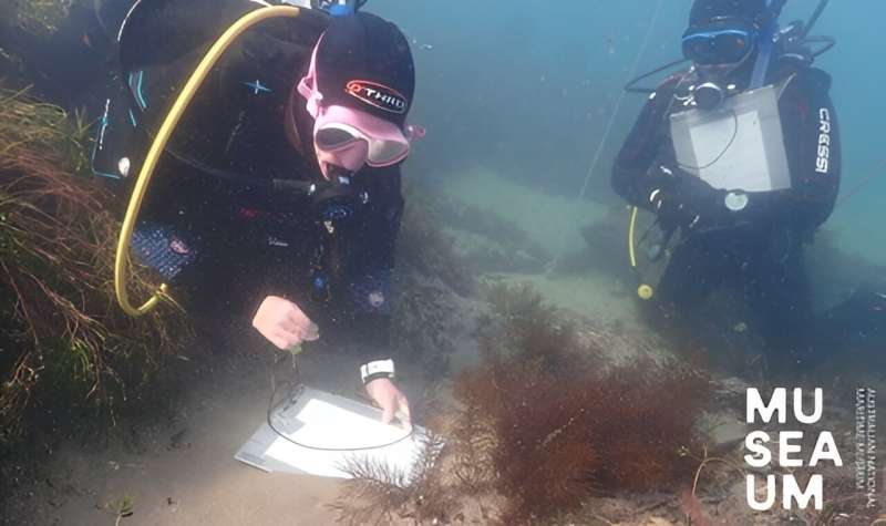
South Australia's oldest shipwreck
Credit: Australian National Maritime Museum

The Australian National Maritime Museum (ANMM) and non-profit Silentworld Foundation have continued ongoing archaeological investigation of the wreck of South Australian, with recent research from a combined team of experts published in the journal Historical Archaeology.

The South Australian is South Australia's oldest known European shipwreck. The English barque, wrecked in in 1837 in Encounter Bay near modern-day Victor Harbor, has drawn keen interest since its discovery in 2018. The wreck site project team includes members of the ANMM, Silentworld Foundation, South Australian Maritime Museum, South Australia's Department for Environment and Water, Flinders University, and MaP fund.

Originally a postal packet called Marquess of Salisbury, which delivered mail between England and far-flung outposts of the British Empire from 1820, the vessel later operated as a British naval packet, named HMP Swallow, before being procured by the South Australian Company, which re-named the ship South Australian.

The ship was designed to carry a huge amount of sail on a relatively small hull for maximum speed. While it transported approximately 80 immigrants to the new colony, its primary function was as a "cutting-in" vessel, or flensing platform, where blubber was removed from harpooned whales as part of the shore-based whaling industry at Encounter Bay.

While loaded with whale oil and readying for departure to Hobart, South Australian was caught in a south easterly gale and wrecked on 8 December 1837. There were no fatalities, and the ship ultimately broke up and was forgotten until the 1990s, when it was the subject of two unsuccessful shipwreck surveys conducted by the South Australian government.

Data collected during these expeditions and archival information helped the research team to establish a new search area that led to South Australian's discovery in April 2018. Remnants of the ship exposed above the seabed included timber framing and hull planking, copper keel bolts, and fragments of glass and pottery.

COVID-19 travel restrictions interrupted further visits to South Australian for two years, but in 2022 maritime archaeologists from the ANMM and an archaeological conservator from the Silentworld Foundation, accompanied by volunteers, returned to continue work at the site.

Photogrammetric 3D recording was carried out in conjunction with site mapping. The team also conducted a comprehensive conservation assessment to determine the wreck site's level of preservation and suggest strategies for its continued protection.

Ongoing work at the site has included comprehensive documentation of exposed hull components and targeted recovery of at-risk diagnostic artifacts. A small selection of objects was also mapped in place and recovered. The items include a gun flint, decorated ceramic fragments, ship's fasteners, glass bottles and a whetstone used to sharpen tools. All are currently undergoing conservation.

Dr. James Hunter, ANMM's Curator of Naval Heritage and Archaeology, and an Associate Lecturer of Archaeology at Flinders University, concluded in the article recently published in Historical Archaeology:

"South Australian's historical and archaeological significance cannot be overstated. As South Australia's oldest recorded European shipwreck, and one of its earliest immigration vessels, it has the potential to enhance our understanding of the state's initial colonization and occupation—including the establishment of extractive mercantile activities, such as shore-based whaling and interactions between European colonists and Aboriginal people.

"Similarly, the site's distinction as one of only two (former) 19th-century British sailing-packet shipwrecks to undergo archaeological scrutiny brings an international dimension to its significance. While a sizable percentage of South Australian's surviving fabric remains buried, recent seabed changes are uncovering the site at an alarming rate. This has reinforced the need for additional investigation and inquiry and underscores the urgency with which site stabilization efforts should be adopted and enacted."

While weather and water visibility impeded efforts to complete the 3D photogrammetric survey of South Australian in late 2022, imagery from this and prior surveys has since been used to generate a digital 3D model of most of the site. This in turn will form the basis of a virtual reality experience currently under development at Germany's University of Applied Sciences, Kaiserslautern. South Australian is also the subject of a graphic novel based on research and archival sources, including the original logbook, which will bring its story to vivid life for new audiences.

The team's work continues, and they aim to conduct further archaeological investigation of South Australian and finish the photogrammetric survey during the latter half of 2023.

More information: James W. Hunter et al, Unearthing South Australia's Oldest Known Shipwreck: The Bark South Australian (1837), Historical Archaeology (2023). DOI: 10.1007/s41636-023-00403-5

Provided by Australian National Maritime Museum

Appeals court strikes down Utah oil railroad approval, siding with environmentalists


SALT LAKE CITY (AP) — A U.S. Appeals Court on Friday struck down a critical approval for a railroad project that would have allowed oil businesses in eastern Utah to significantly expand fossil fuel production and exports.

The ruling is the latest development in the fight over the proposed Uinta Basin Railway, an 88-mile (142-kilometer) railroad line that would connect oil and gas producers in rural Utah to the broader rail network, allowing them to access larger markets and ultimately sell to refineries near the Gulf of Mexico. The railroad would let producers, currently limited to tanker trucks, ship an additional 350,000 barrels of crude daily on trains extending for up to 2 miles (3.2 kilometers).

The Washington, D.C.-based appeals court ruled that a 2021 environmental impact statement and biological opinion from the federal Surface Transportation Board were rushed and violated federal laws. It sided with environmental groups and Colorado's Eagle County, which had sued to challenge the approval.

The court said the board had engaged in only a “paltry discussion” of the environmental impact the project could have on the communities and species who would live along the line and the “downline” communities who live along railroads where oil trains would travel.

“The limited weighing of the other environmental policies the board did undertake fails to demonstrate any serious grappling with the significant potential for environmental harm stemming from the project,” the ruling stated.

Surface Transportation Board spokesperson Michael Booth said the agency does not comment on pending litigation.

Though the Uinta Basin Railway proposal still must win additional approvals and secure funding before construction can begin, proponents saw the 2021 environmental impact statement from the board as among the most critical approvals to date.

The statement received pushback from environmentalists concerned that constructing new infrastructure to transport more fossil fuels will allow more oil to be extracted and burned, contributing to climate change.

Additionally, communities in neighboring Colorado including Eagle County and the city of Glenwood Springs — which filed a brief in support of the lawsuit — are worried about safety and potential train derailments. Oil trains would link from the proposed new Uinta Basin line to the common carrier network throughout the country, including through Colorado.

Proponents — oil businesses, rural Utah officials and the Ute Indian Tribe of the Uintah & Ouray Reservation — have argued that the railroad would be a boon to struggling local economies and boost domestic energy production.

The court ultimately ruled that the Surface Transportation Board's decision to grant the project an exemption from the typical review process and claims that it could not examine its full environmental impact violated the agency's mandate.

"The Board’s protestations at argument that it is just a ‘transportation agency’ and therefore cannot allow the reasonably foreseeable environmental impacts of a proposed rail line to influence its ultimate determination ignore Congress’s command that it make expert and reasoned judgments," it said.

The local agency guiding the project through the approval process and the developer seeking funding for it said in a statement that they were undeterred by the ruling and planned to continue seeking approvals.

“We are ready, willing, and capable of working with the U.S. Surface Transportation Board to ensure additional reviews and the project’s next steps proceed without further delay. We look forward to bringing this railway to the basin,” the Seven County Infrastructure Coalition and DHIP Group said in a joint statement.

Deeda Seed of the Center for Biological Diversity characterized the decision as a victory and demanded that President Joe Biden's administration stop the project from seeking any further approvals.

“The Uinta Basin Railway is a dangerous, polluting boondoggle that threatens people, wildlife and our hope for a livable planet," she said in a written statement.

__

Associated Press writer Josh Funk in Omaha, Nebraska, contributed to this report.

Sam Metz, The Associated Press


Satellites and DNA reveal new insights into the western Pacific's rapidly declining hawksbill turtle population

Satellites and DNA reveal new insights into western Pacific's rapidly declining hawksbill turtles
Credit: Kaz Hing/WWF

For the first time, a new study reveals that many hawksbill turtles satellite-tagged in Papua New Guinea's (PNG) Conflict Islands swam more than 1,000 km to reach the Great Barrier Reef to forage, a journey taking more than a month.

But hawksbills satellite-tagged in northeast Queensland's Milman Island stayed in Australian waters, mostly swimming north to forage in Torres Strait and around to western Cape York, according to a separate Queensland-focused study. Both papers on the critically endangered species were recently published in Frontiers in Marine Science.

The research showed the importance of safeguarding hawksbill migratory routes and foraging habitats in northeast Australia, said lead author of both papers, Christine Madden Hof, a Ph.D. candidate at the University of Sunshine Coast and leader of WWF's Global Marine Turtle Conservation program.

"That's why conservationists applauded the Queensland and Australian governments' recent commitment to phase out commercial gill nets in the Great Barrier Reef," she said.

"Significant numbers of hawksbills either nest and permanently live in Queensland or travel long distances to forage here. So improved protection in north east Australia and the reefs surrounding Cape York is critical to saving this species," she said.

"It is critical not just for the severely declining Milman Island population, but for hawksbill populations across the entire western Pacific.

"Following on from the Great Barrier Reef gill net phase out, we're keen to work with the Queensland government to implement net-free areas and support greater Indigenous or marine protected areas in western Cape York.

"It's clear from the satellite tracking hawksbills are heading there, and our modeling shows it can be a dangerous place for a turtle."

Queensland study assesses migration patterns and threats

The Queensland study assessed the mortality risk to hawksbills. In western Cape York, where there is currently little to no protection, in large areas that risk was rated high to very high.

Threats include fishing nets and ghost gear, direct harvest, and increasing sand temperatures due to climate change.

Simon Miller, a co-author of the Queensland research and Great Barrier Reef fisheries expert at the Australian Marine Conservation Society said the findings demonstrated why gill nets had to be removed from the Great Barrier Reef and why new net-free areas were urgently needed in the western Cape.

"There is also a clear need for greater independent scrutiny of commercial fishing in hawksbill home ranges to give us an accurate picture of what is being caught," Miller said.

Milman Island is the main nesting beach for what used to be a globally significant population of genetically distinct hawksbills known as the northeast Queensland stock.

A recent assessment, co-authored by Madden Hof, revealed an alarming 58% decline over the last 28 years. It also predicts this population may be functionally extinct by 2032 if the current trajectory continues. Scientists fear a similar decline could also be occurring across the larger southwestern Pacific population.

Scientists fear a similar decline could also be occurring across the larger southwestern Pacific population.

PNG study on migration patterns and genetics

Genetic sampling of female hawksbills nesting in the Conflict Islands' group and about 1,000 km further north in Kavieng revealed they are significantly different from one another and all other known Asia-Pacific stocks.

With the addition of these two, nine genetically distinct populations have now been identified in the Asia-Pacific region, but researchers believe there are many more. They say each will need to be managed separately to ensure  recovery.

Co-author Hayley Versace, manager at Conflict Islands Conservation Initiative said the Islands were one of the most important sites in PNG for hawksbills, shared across vast migratory routes, with Australia and other Pacific nations.

"We need to continue to support local communities to collectively manage this resource for future generations to come," she said.

PNG has no legislation to protect hawksbills. But given the plight of the species that could change.

Vagi Rei, Manager Marine Division from the Conservation and Environment Protection Agency of Papua New Guinea, said sea turtle harvesting for shell, meat and eggs continued in PNG and the Torres Strait in Australia under the Torres Strait Treaty, with no legislative or regulated quota limits.

"This study has highlighted the need for greater national protection for hawksbills but given the migratory and foraging connectivity to eastern Cape York, stronger regional co-management and cooperation between the PNG and Australian Government is required," he said.

More information: Christine A. Madden Hof et al, From rookeries to foraging grounds: understanding regional connectivity and genetic diversity in hawksbill turtles, Frontiers in Marine Science (2023). DOI: 10.3389/fmars.2023.1201009

Christine A. Madden Hof et al, Delineating spatial use combined with threat assessment to aid critical recovery of northeast Australia's endangered hawksbill turtle, one of western Pacific's last strongholds, Frontiers in Marine Science (2023). DOI: 10.3389/fmars.2023.1200986

Can soil microbes survive in a changing climate?

Can soil microbes survive in a changing climate?
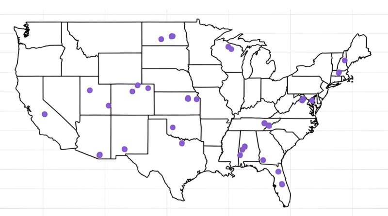
Dots on the map indicate where soil samples were collected across the U.S. by NEON. 
Credit: University of Miami

Organisms across the globe are facing unprecedented levels of stress from climate change, habitat destruction, and many other human-driven changes to the environment. Predicting and mitigating the effects of this increasing stress on organisms, and the environmental services on which we depend, requires understanding why some species can exist in a wide range of environments while others exist in only a few habitats.

In the scientific world of ecology, researchers often try to sort organisms on our planet into two categories: specialists and generalists. Generalists can survive across various environmental conditions and habitats, while specialists are more restricted or limited to specific conditions for survival. The panda bear, for example, feeds only on bamboo within a specific habitat. Not only is their habitat range-restricted, but so is their diet, and if the bamboo plant became extinct, panda bears might become extinct as well.

But what about the microbial world of unseen organisms found everywhere on Earth, from the human gut to the soil under our feet? Into which category do they fall?

To find the answer, a group of graduate and postdoc students in Associate Professor Michelle Afkhami's biology lab at the University of Miami College of Arts and Sciences studied the DNA sequences of prokaryotes, a group of microbes that include all bacteria and archaea.

The findings are in a study, titled "Multidimensional specialization and generalization are pervasive in soil prokaryotes," available in the journal Nature Ecology & Evolution.

"The idea behind the project was to find out whether these microbes can exist within a narrow or broad range of conditions along many different environmental dimensions," said Damian Hernandez, a former graduate student in Afkhami's lab and now a postdoc preparing for a biology fellowship with the National Science Foundation.

"Specifically, we wanted to know whether microbes are typically multidimensional specialists, multidimensional generalists, or use different strategies on different environmental dimensions—and what effect that could have on their roles within communities.

"The environmental dimensions we used to determine whether the microbes are generalists or specialists were based on multiple environmental conditions in the soil in which they live, for example, leaf litter, temperature, water, and nutrients," he added.

In a  two years in the making, the team of students analyzed over 200 soil samples collected by the National Ecological Observatory Network (NEON) from sites across the United States. Of the over 1,200 prokaryotes examined, Hernandez and the team found something quite surprising. They found that the majority (90 percent) of the microbes were either multidimensional generalists or multidimensional specialists.

Essentially, if a microbe was a generalist across one environmental axis, it was almost always a generalist across all other axes; and if it was a specialist on one environmental axis, it specialized across all axes. In addition to providing important insight into how microbial communities are structured, this discovery provides some of the first evidence for multidimensional specialization and generalization in any type of organism.

"We found that microbes can be very restricted on where they can exist," said Hernandez, who is the first author of the study. "The generalist microbes are very flexible and can withstand a broader range of conditions. But the specialist microbes are sensitive to many different environmental conditions because they are restricted on multiple environmental axes and thus any changes in the environment may hinder their survival.

"Hypothetically, if an ecosystem is structured by microbes that are specialists, then those ecosystems are more likely to be sensitive to environmental change," he said.

Afkhami confirms that the findings present an interesting argument on how microbes can survive in a changing climate.

"As we learned from the study, microbes that are generalists can live across a wide range of habitats, and this can mean that those microbes may be resilient to  or habitat fragmentation because they are likely to tolerate changing environmental conditions. They are also very dominant within ," she said.

In contrast, the team found that specialist microbes can be very susceptible to environmental change. Microbes categorized as specialists also appear to be important "community organizers" due to their high functionality within the microbial world. For example, the research team discovered that specialist microbes are more likely to be those that can promote plant growth, detoxify the soil, digest complex carbons in the soil, and add nutrients to the soil.

"This is very concerning because what we also learned in the study is that microbial specialists are highly connected within the microbial network and can be considered as keystone species for maintaining and driving the diversity and function of the microbiome," said Afkhami.

"In this study, we can start to understand—across a wider sense in the microbiome community—some of their biological functions, their roles in the microbial community, and how they will respond to global changes on the planet."

More information: Damian J. Hernandez et al, Multidimensional specialization and generalization are pervasive in soil prokaryotes, Nature Ecology & Evolution (2023). DOI: 10.1038/s41559-023-02149-y


Provided by University of Miami Plant life found to determine soil bacteria diversity in the Arctic tundra


New UCF project examines key role soils play in keeping the planet cool


The research, funded by a grant from the USDA National Institute of Food and Agriculture, will examine a method to keep carbon from escaping soils and trapping heat in Earth’s atmosphere.

Grant and Award Announcement

UNIVERSITY OF CENTRAL FLORIDA

UNIVERSITY OF CENTRAL FLORIDA


New UCF Project Examines Key Role Soils Play in Keeping the Planet Cool

The research, funded by a grant from the USDA National Institute of Food and Agriculture, will examine a method to keep carbon from escaping soils and trapping heat in Earth’s atmosphere.

ORLANDO, Aug.17, 2023 – A new project from the University of Central Florida is looking to the soils for a way to cool the skies.

Funded by a nearly $750,000 grant from the USDA National Institute of Food and Agriculture, the research will examine a method to keep carbon from escaping soils and becoming the greenhouse gas carbon dioxide. As carbon dioxide accumulates in the atmosphere, it warms the Earth by trapping heat.

The research is important as NASA has reported that the Earth has seen some of the hottest temperatures on record this summer.

“When we talk about climate change, a lot of people have the misperception that most of the Earth’s carbon is stored in the atmosphere,” says Lisa Chambers, the project’s principal investigator and an associate professor in UCF’s Department of Biology. “But the atmospheric carbon pool is actually quite small, relative to the pool of carbon in the soil.”

The research will focus on histosols, or organic rich soils, in the Everglades Agricultural Area located south of Lake Okeechobee in Florida.

Histosols comprise only about 1.3% of Earth’s land surface, but store approximately 23% of its carbon. The nutrient-rich soils are perfect for agriculture, but their drainage and cultivation lead to increased carbon dioxide in the atmosphere.

The research team, which includes Jehangir Bhadha with the University of Florida and Jing Hu with Mississippi State University, will examine adding fine minerals — such as silt and clays — to the histosols to prevent carbon from escaping.

Research has found that mineral-associated organic matter releases less carbon into the atmosphere because it is less susceptible to decomposition by microbes.

“It’s been shown through carbon-14 dating that the carbon that’s associated with these fine silts and clays has remained in the soil the longest,” Chambers says. “Whereas unassociated, loose organic matter only dates back tens to hundreds of years old and is easily decomposed by microbes into CO2, the mineral-associated organic matter has been aged to be millennia.”

She says the Everglades Agricultural Area is the perfect place to perform the research because not only could the work help with climate change, but it could also improve agricultural production and sustainability in the area.

Soil subsidence due to decomposing histosols has become a major problem in the Everglades Agricultural Area, where in some locations soil elevation has dropped as much as six feet over the past 100 years.

“The soil has been so unprotected and oxidizing so fast, that there are places where the soils are almost completely gone, turned back into carbon dioxide in the atmosphere, and they're almost down to bedrock,” she says. “So, it's kind of a precarious situation.”

The four-year project will involve surveying the current status of mineral-associated organic matter in the area, lab experiments to determine the best soil formulations and field-scale trials. Although the project will focus on South Florida, the findings could have applications in other areas where histosols have been drained for agricultural production.

Chambers received her doctorate in wetland biogeochemistry from the University of Florida and joined the Department of Biology in UCF’s College of Sciences in 2015. She is the principal investigator of the Aquatic Biogeochemistry Laboratory and is also a member of UCF’s National Center for Integrated Coastal Research.

CONTACT: Robert H. Wells, Office of Research, robert.wells@ucf.edu


Biogeochemical insights from a major Amazonian river

Biogeochemical insights from a major Amazonian river
The sun sets over the Tocantins River, a major artery in the Amazon Basin, near the
 village of Moiraba, Brazil. Until recently, researchers lacked baseline biogeochemical
 characteristics for the Tocantins, as is the case for many tropical rivers. 
Credit: Camsidou/Wikimedia Commons, CC BY-SA 4.0

Rivers provide water to billions of people and are critical linkages between continental ecosystems and oceans. Every run and every riffle reshape the surrounding landscape as a river transports nutrients and sediment downstream. Yet many rivers, including large tributaries in the Amazon Basin, the largest river basin in the world, are understudied. The resulting data gap casts uncertainty onto carbon budgets and nutrient flux estimates at both regional and global scales.

One such understudied river, the Tocantins River in Brazil, drains both Amazon and Cerrado biomes and empties into the Atlantic Ocean, where it mixes with the vast plume of water emerging from the Amazon and Pará Rivers. Loss of native vegetation cover in the Tocantins Basin, which represents 11% of Brazil's land mass, has been driven by agricultural and hydroelectric development and has been so pervasive that it has altered the basin's hydrologic regime.

In new research, Vania Neu and colleagues studied water quality, carbon and  in the region, and biogeochemical fluxes to the ocean—and whether these traits have been affected by land use changes. Taking monthly samples from the Tocantins River for more than two years, they measured the composition and transport of carbon, nitrogen, and suspended sediment to establish the basin's biogeochemical characteristics. The findings are published in the Journal of Geophysical Research: Biogeosciences.

The findings show that the Tocantins River contributes 3% of dissolved carbon and 3.7% of dissolved nitrogen to the total Amazon River plume and that seasonal fluctuations largely dictate the river's carbon and nitrogen composition. During the  enters the river from the terrestrial environment. In the dry season, however, water chemistry is more closely tied to algal and planktonic decomposition. The research did not establish clear connections between  on the surrounding landscape, like deforestation, and water chemistry.

The research represents the first detailed evaluation of carbon and nitrogen in the Tocantins River, providing baselines that will be central to understanding human-driven environmental change in the basin in the future, the authors say. The work also highlights the need for investigations into other understudied rivers worldwide, particularly in the tropics.

More information: Vania Neu et al, Composition and Flux of Dissolved and Particulate Carbon and Nitrogen in the Lower Tocantins River, Journal of Geophysical Research: Biogeosciences (2023). DOI: 10.1029/2022JG006846


Provided by American Geophysical Union


This story is republished courtesy of Eos, hosted by the American Geophysical Union. Read the original story here.

Tree ring data brings insight to drought variability in central Yunnan

tree rings
Credit: CC0 Public Domain

Southwest China, including Yunnan Province, is prone to severe droughts due to the failure of summer monsoon precipitation. Despite the great potential for dendroclimatological studies in Yunnan, there have been very few attempts at tree-ring derived climate reconstructions in the central and southern parts of Yunnan, especially in the subtropics.

In a study published in Palaeogeography, Palaeoclimatology, Palaeoecology, researchers from the Xishuangbanna Tropical Botanical Garden (XTBG) of the Chinese Academy of Sciences and their collaborators attempted to gain insights into hydroclimate variability in central Yunnan Province. They constructed a tree-ring width chronology of Tsuga dumosa, one of the oldest tree species in the Wuliang Mountain area that has previously shown to be suitable for reconstructing hydroclimate variability.

Correlation analyses indicated that moisture availability during the spring/early summer season was the key factor limiting tree growth of T. dumosa in the Wuliang Mountain. The radial growth of T. dumosa showed a  with temperature, especially in April before the . Low precipitation and humidity in March–April reduced the radial growth of T. dumosa.

The researchers reconstructed the March–June standardized precipitation-evapotranspiration index (SPEI) for the period from 1826 to 2020 CE, by using a well-calibrated regression model. The reconstructed March–June SPEI series revealed drought fluctuations at both interannual and interdecadal scales, along with an increased occurrence of extreme dry/wet events in recent decades.

In addition, the reconstruction identified 11 years of extreme drought, with the longest recorded dry and wet periods being 1953–1963 and 1988–2004, respectively. The  reconstruction series showed a high frequency cycle of two to eight years. The reconstruction also showed a higher frequency of extreme dry/wet events after the 1960s , which was not found in other parts of Yunnan.

"Our study highlights the dendroclimatic potential of conifer tree species growing in  and their ability to capture regional hydroclimatic signals," said Fan Zexin of XTBG.

More information: Yun-Li Yin et al, Tree rings in Tsuga dumosa reveal increasing drought variability in subtropical southwest China over the past two centuries, Palaeogeography, Palaeoclimatology, Palaeoecology (2023). DOI: 10.1016/j.palaeo.2023.111757


Some plants do not shed their leaves in autumn, for good reason

Some plants do not shed their leaves in autumn, for good reason
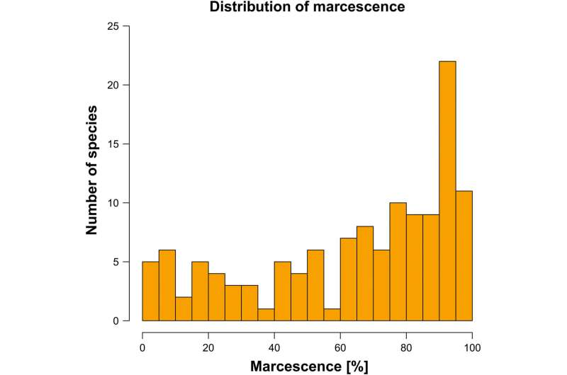
Histogram of proportions of marcescent phytomass to total above-ground dead phytomass (senescent and marcescent dead phytomass) in the 127 sampled species. Numbers of species within each category of marcescence are shown. Credit: Journal of Ecology (2023). DOI: 10.1111/1365-2745.14174

Retention of dead biomass by plants is common in the temperate herbaceous flora and can be related to certain plant traits, indicating relevance to ecosystem functioning. These are the main findings of an experimental study on more than 100 plant species jointly performed by researchers from the German Center for Integrative Biodiversity Research (iDiv), Leipzig University, the Czech Academy of Sciences, and the Charles University, Prague. The study has recently been published in the Journal of Ecology.

As the winter approaches and first freezing temperatures sweep across temperate climates,  become dormant and shed their leaves. However, some  and grasses retain their leaves and stalks during autumn and winter, although already pale and without color. This phenomenon, termed marcescence, can be recognized all around when walking through a snowy landscape. But has marcescence a function in nature or is it a remnant from the bygone summer without specific meaning?

We knew that marcescence had been relatively well researched in arid ecosystems, in which  strongly degrades difficult-to-decompose compounds in retained biomass. This facilitates decomposition of and nutrient release from that biomass once shed, with potential competitive advantages for the respective plants.

In , however, research has been scarce and mainly focused on , with few exceptions, and virtually nothing is known about marcescence in the temperate herbaceous flora, although simple observations indicate that it is widespread. We thus asked ourselves how common marcescence is in our latitudes and whether it can be linked to certain plant traits.

Fortunately, we had access to a large common garden experiment that was running at the botanical gardens in Prague. The experiment was ideal to tackle our research question as a large variety of plants were grown in the same soil substrate and under the same climate. We created a battle plan and finally sampled dead biomass from 127 plants shortly before the start of the subsequent growing season, determined the proportion of marcescence for each of these plants, and related this proportion to plant functional traits.

To our surprise, almost all of the investigated plants (123 of 127) kept at least part of their biomass marcescent, indicating the commonness of marcescence in the temperate flora. Marcescence particularly predominated in tall  with small leaves and high carbon concentrations in their tissues and in those commonly preferring intensely disturbed sites.

Marcescence may thus provide advantages for certain plants in the initial stages of succession and might influence carbon and nutrient cycling. As we are just beginning to understand the determinants and function of marcescence in temperate regions, intensified  efforts are crucially needed to disentangle the relevance of this widely overlooked phenomenon to ecosystem functioning.

More information: Ondřej Mudrák et al, Ecological significance of standing dead phytomass: Marcescence as a puzzle piece to the nutrient cycle in temperate ecosystems, Journal of Ecology (2023). DOI: 10.1111/1365-2745.14174


Journal information: Journal of Ecology 


Provided by German Centre for Integrative Biodiversity Research (iDiv)Halle-Jena-LeipzigMeta-analysis elucidates how fine-root functional traits respond to experimental warming in woody plants


Rising methane could be a sign that Earth's climate is part way through a 'termination-level transition'

Rising methane could be a sign that Earth's climate is part way through a 'termination-level transition'
Soaring wetland emissions of methane reflect those which accompanied previous abrupt
 changes in Earth’s climate. Credit: I. Noyan Yilmaz/Shutterstock

Since 2006, the amount of heat-trapping methane in Earth's atmosphere has been rising fast and, unlike the rise in carbon dioxide (CO₂), methane's recent increase seems to be driven by biological emissions, not the burning of fossil fuels. This might just be ordinary variability—a result of natural climate cycles such as El Niño. Or it may signal that a great transition in Earth's climate has begun.

Molecule for molecule,  is a much more potent greenhouse gas than CO₂ but it lasts slightly less than a decade in the atmosphere compared with centuries for CO₂. Methane emissions threaten humanity's ability to limit warming to relatively safe levels. Even more troubling, the rate at which methane is increasing in the atmosphere has accelerated recently. Something like this has happened before: sudden surges in methane marked the transitions from cold ice ages to warm interglacial climates.

Methane was about 0.7 parts per million (ppm) of the air before humans began burning fossil fuels. Now it is over 1.9 ppm and rising fast. Roughly three-fifths of emissions come from fossil fuel use, farming, landfills and waste. The remainder is from natural sources, especially vegetation rotting in tropical and northern wetlands.

Methane is both a driver and a messenger of climate change. We don't know why it is now rising so rapidly, but the pattern of growth since late 2006 resembles how methane behaved during great flips in Earth's climate in the distant past.

The methane record: 2006 to present

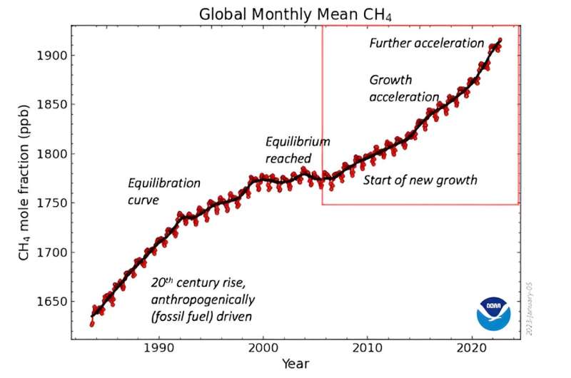
In late 2006, atmospheric methane unexpectedly began rising. Methane had risen fast in the 19th and 20th centuries but plateaued by the end of the 1990s. This rise was driven by fossil fuel emissions, especially from gasfields and coal mines.

Imagine accelerating a car with your foot flat down. The car speeds up but eventually air resistance equals engine power and the car hits maximum speed. In 1999, it looked like methane had reached a similar equilibrium between its sources and sinks. Then in late 2006, the amount of methane in the air climbed fast. Even more unexpectedly five years later, the rate of growth sped up again. During the 2020s the  has become yet faster, faster even than during the peak of gas industry leaks in the 1980s.

Today's growth seems to be driven by new emissions from wetlands, especially near the equator but perhaps also from Canada (beavers are methane factories which pull huge amounts of plant matter into ponds they've made) and Siberia. This is a result of climate change: increasing rainfall has made wetlands wetter and bigger while rising temperatures have boosted plant growth, providing more decomposing matter and so more methane. Emissions from huge cattle lots in tropical Africa, India and Brazil may also be rising and rotting waste in landfills near megacities like Delhi are important sources too.

Rising methane could be a sign that Earth's climate is part way through a 'termination-level transition'
Methane in the air rose rapidly from 2006—then it rose again, and again.
 Credit: NOAA/Nisbet et al. (2023), Author provided

Climate terminations

In the past few million years, Earth's climate has flipped repeatedly between long, cold glacial periods, with ice sheets covering northern Europe and Canada, and shorter warm inter-glacials.

When each ice age ended, Earth's surface warmed by as much as several degrees centigrade over a few millennia. Recorded in air bubbles in ice cores, sharply rising methane concentrations are the bellwethers of these great climate-warming events. With each flip from a glacial to an interglacial climate there have been sudden, sharp rises in atmospheric methane, likely from expanding tropical wetlands.

These great climate flips that ended each ice age are known as terminations. Each has a Roman numeral, ranging from Termination IX which happened about 800,000 years ago to Termination IA which initiated the modern climate less than 12,000 years ago. For example, around 131,000 years ago during Termination II, the British climate suddenly flipped from glaciers in the Cotswolds to hippopotami wallowing in what is now Trafalgar Square.

Full terminations take several thousands of years to complete, but many include a creeping onset of warming, then a very abrupt phase of extremely rapid climate change that can take a century or less, followed by a longer, slower period during which the great ice caps finally melt. In the abrupt phase of the great change that brought about the modern climate, Greenland's temperature rose by around 10°C within a few decades. During these abrupt phases, methane climbs very steeply indeed.

Is something dramatic underway?

Methane fluctuated widely in pre-industrial times. But its increasingly rapid growth since 2006 is comparable with records of methane from the early years of abrupt phases of past termination events, like the one that warmed Greenland so dramatically less than 12,000 years ago.

There is already lots of evidence that the climate is shifting. Atlantic ocean currents are slowing, tropical weather regions are expanding, the far north and south are warming fastocean heat is breaking records and extreme weather is becoming routine.

In glacial terminations, the entire climate system reorganizes. In the past, this took Earth out of stable ice age climates and into warm inter-glacials. But we are already in a warm interglacial. What comes next is hard to imagine: loss of sea ice in the Arctic in summer, thinning or partial collapse of the ice caps in Greenland and West Antarctica, reorganization of the Atlantic's ocean currents and the poleward expansion of tropical weather circulation patterns. The consequences, both for the biosphere in general and food production in south and east Asia and parts of Africa in particular, would be very significant.

There's much to be done that could hastily stop methane's rise: plugging leaks in the oil and gas industry, covering landfills with soil, reducing crop-waste burning. Shooting the methane messenger won't stop climate change, which is primarily driven by CO₂ emissions, but it will help.

Roman numerals IX to I denote past great climate transitions. There is no Roman number zero, but then any future termination-scale transition will be different—a temperature step from our present interglacial  to some new future that is warmer yet. Methane's signal is still unclear, but the question remains: has Termination Zero begun?

Provided by The Conversation 

This article is republished from The Conversation under a Creative Commons license. Read the original article.The ConversationDelaying methane mitigation increases risk of breaching Paris Agreement climate goal, study finds