Monday, March 02, 2020

New version of Earth model captures detailed climate dynamics
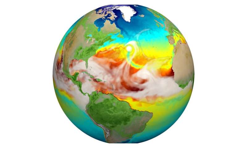
Water vapor (gray) and sea surface temperature (blue to red) from the high-resolution E3SMv1. Just above center you can see a hurricane and the track of cold water (green) it produces trailing behind it. Credit: Mat Maltrud / Los Alamos National Laboratory
Earth supports a breathtaking range of geographies, ecosystems and environments, each of which harbors an equally impressive array of weather patterns and events. Climate is an aggregate of all these events averaged over a specific span of time for a particular region. Looking at the big picture, Earth's climate just ended the decade on a high note—although not the type one might celebrate.
In January, several leading U.S. and European science agencies reported 2019 as the second-hottest year on record, closing out the hottest decade. July went down as the hottest month ever recorded.
Using new high-resolution models developed through the U.S. Department of Energy's (DOE) Office of Science, researchers are trying to predict these kinds of trends for the near future and into the next century; hoping to provide the scientific basis to help mitigate the effects of extreme climate on energy, infrastructure and agriculture, among other essential services required to keep civilization moving forward.
Seven DOE national laboratories, including Argonne National Laboratory, are among a larger collaboration working to advance a high-resolution version of the Energy Exascale Earth System Model (E3SM). The simulations they developed can capture the most detailed dynamics of climate-generating behavior, from the transport of heat through ocean eddies—advection—to the formation of storms in the atmosphere.
"E3SM is an Earth system model designed to simulate how the combinations of temperature, winds, precipitation patterns, ocean currents and land surface type can influence regional climate and built infrastructure on local, regional and global scales," explains Robert Jacob, Argonne's E3SM lead and climate scientist in its Environmental Science division. "More importantly, being able to predict how changes in climate and water cycling respond to increasing carbon dioxide (CO2) is extremely important in planning for our future."
"Climate change can also have big impacts on our need and ability to produce energy, manage water supplies and anticipate impacts on agriculture" he adds, "so DOE wants a prediction model that can describe climate changes with enough detail to help decision-makers."
Facilities along our coasts are vulnerable to  caused, in part, by rapid glacier melts, and many energy outages are the result of extreme weather and the precarious conditions it can create. For example, 2019's historically heavy rainfalls caused damaging floods in the central and southern states, and hot, dry conditions in Alaska and California resulted in massive wild fires.
And then there is Australia.
To understand how all of Earth's components work in tandem to create these wild and varied conditions, E3SM divides the world into thousands of interdependent grid cells—86,400 for the atmosphere to be exact. These account for most major terrestrial features from "the bottom of the ocean to nearly the top of the atmosphere," collaboration members wrote in a recent article published in the Journal of Advances in Modeling Earth Systems.
"The globe is modeled as a group of cells with 25 kilometers between grid centers horizontally or a quarter of a degree of latitude resolution," says Azamat Mametjanov, an application performance engineer in Argonne's Mathematics and Computer Science division. "Historically, spatial resolution has been much coarser, at one degree or about 100 kilometers. So we've increased the resolution by a factor of four in each direction. We are starting to better resolve the phenomena that energy industries worry about most—extreme weather."
Researchers believe that E3SM's higher-resolution capabilities will allow researchers to resolve geophysical features like hurricanes and mountain snowpack that prove less clear in other models. One of the biggest improvements to the E3SM model was sea surface temperature and sea ice in the North Atlantic Ocean, specifically, the Labrador Sea, which required an accurate accounting of air and water flow.
"This is an important oceanic region in which lower-resolution models tend to represent too much sea ice coverage," Jacob explains. "This additional sea ice cools the atmosphere above it and degrades our predictions in that area and also downstream."
Increasing the resolution also helped resolve the  more accurately, which helped make the Labrador Sea conditions correspond with observations from satellites and ships, as well as making better predictions of the Gulf Stream.
Another distinguishing characteristic of the model, says Mametjanov, is its ability to run over multiple decades. While many models can run at even higher resolution, they can run only from five to 10 years at most. Because it uses the ultra-fast DOE supercomputers, the 25-km E3SM model ran a course of 50 years.
Eventually, the team wants to run 100 years at a time, interested mainly in the climate around 2100, which is a standard end date used for simulations of future climate.
Higher resolution and longer time sequences aside, running such a model is not without its difficulties. It is a highly complex process.
For each of the 86,400 cells related to the atmosphere, researchers run dozens of algebraic operations that correspond to some meteorological processes, such as calculating wind speed, atmospheric pressure, temperature, moisture or the amount of localized heating contributed by sunlight and condensation, to name just a few.
"And then we have to do it thousands of times a day," says Jacob. "Adding more resolution makes the computation slower; it makes it harder to find the computer time to run it and check the results. The 50-year simulation that we looked at in this paper took about a year in real time to run."
Another dynamic for which researchers must adjust their model is called forcing, which refers mainly to the natural and anthropogenic drivers that can either stabilize or push the climate into different directions. The main forcing on the climate system is the sun, which stays relatively constant, notes Jacob. But throughout the 20th century, there have been increases in other external factors, such as CO2 and a variety of aerosols, from sea-spray to volcanic.
For this first simulation, the team was not so much probing a specific stretch of time as working on the model's stability, so they chose a forcing that represents conditions during the 1950s. The date was a compromise between preindustrial conditions used in low-resolution simulations and the onset of the more dramatic anthropogenic greenhouse gas emissions and warming that would come to a head in this century.
Eventually, the  will integrate current forcing values to help scientists further understand how the global climate system will change as those values increase, says Jacob.
"While we have some understanding, we really need more information—as do the public and energy producers—so we can see what's going to happen at regional scales," he adds. "And to answer that, you need models that have more resolution."
One of the overall goals of the project has been to improve performance of the E3SM on DOE supercomputers like the Argonne Leadership Computing Facility's Theta, which proved the primary workhorse for the project. But as computer architectures change with an eye toward exascale computing, next steps for the project include porting the models to GPUs.
"As the resolution increases using exascale machines, it will become possible to use E3SM to resolve droughts and hurricane trends, which develop over multiple years," says Mametjanov.
"Weather models can resolve some of these, but at most for about 10 days. So there is still a gap between weather models and  models and, using E3SM, we are trying to close that gap."
The E3SM collaboration's article, "The DOE E3SM Coupled Model Version 1: Description and Results at High Resolution," appeared in the December 2019 issue of Journal of Advances in Modeling Earth Systems.
SimEarth

More information: Peter M. Caldwell et al. The DOE E3SM Coupled Model Version 1: Description and Results at High Resolution, Journal of Advances in Modeling Earth Systems (2019). DOI: 10.1029/2019MS001870
Above-average autumn temperatures expected even if El Nino unlikely

Above average autumn temperatures expected even if El Niño unlikely
Credit: WMO
Above average temperatures are expected in many parts of the globe in the next few months, even without the presence of a warming El Niño event, according to the World Meteorological Organization.
WMO's El Niño/Southern Oscillation (ENSO) Update said that there is a 60% chance of ongoing ENSO-neutral conditions continuing during March-May 2020. The chances for an El Niño or La Niña are 35% and 5% respectively. For the June-August 2020 season, the chance for ENSO-neutral is 55%, that for El Niño is 20-25% and that for La Niña is also 20-25%.
The El Niño/Southern Oscillation is a naturally occurring phenomenon involving fluctuations of  surface temperatures in the equatorial Pacific, coupled with changes in the overlying atmospheric circulation. It has a major influence on weather and  and is linked to hazards such as heavy rains, floods and drought. El Niño typically has a warming influence on , whilst La Niña has the opposite effect.
El Niño and La Niña are not the only naturally occurring phenomena that drive global  patterns. WMO has therefore introduced a new Global Seasonal Climate Update, currently in a trial phase, which factors in other climate drivers such as the Indian Ocean Dipole.
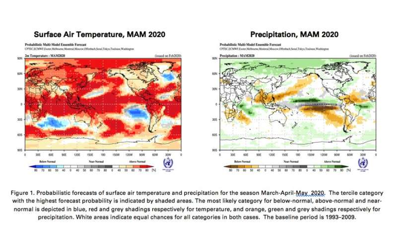
The Global Seasonal Climate Update said that above average sea surface temperatures are likely across sizeable portions of the globe, both in the tropics and extra-tropics. As a result, the forecast for March-May 2020 leans towards above-normal land temperature, particularly at tropical latitudes.
The global warming trend also contributes to the above-average sea surface temperature and air  forecast, it said.
"Even ENSO neutral months are warmer than in the past, as air and sea surface temperatures and ocean heat have increased due to climate change. With more than 90% of the energy trapped by greenhouse gases going into the ocean, ocean heat content is at record levels," said WMO Secretary-General Petteri Taalas.
"Thus, 2016 was the  on record as a result of a combination of a strong El Niño and human-induced global warming. 2019 was the second warmest year on record, even though there was no strong El Niño. We just had the warmest January on record. The signal from human-induced climate change is now as powerful as that from a major natural force of nature," said Mr Taalas.
Even though ENSO neutral conditions have prevailed since last July, there was a strong positive phase of the Indian Ocean Dipole (IOD) – sometimes known as the "Indian Niño." This was linked to drought which contributed to bush fires in Australia, and above average rainfall and flooding in Eastern Africa, the latter setting the scene for the current desert locust crisis in the region. The Indian Ocean Dipole is now neutral.
Above normal precipitation is expected just north of the equator in the central tropical Pacific and southwestern Indian Ocean extending into eastern equatorial Africa. Elevated probabilities of below-normal precipitation extend over much of the rest of the western tropical and extratropical Pacific. Below-normal precipitation is also likely for northern South America, Central America and the Caribbean, and southern Africa, according to WMO's Global Seasonal Climate Update. Southeast Asia, Oceania and western Australia, as well as southern Africa, Central America and the Caribbean, all also experienced drier to much drier than normal anomalies over the preceding November-January season. An outlook for continued dry conditions in these sub-regions suggests that they should be closely monitored in the coming months.
WMO Global Seasonal Climate Updates are based on climate model predictions around the world from WMO Global Producing Centres of Long Range Forecasts.
Both tools are used by planners within the United Nations system, and complement information issued by National Meteorological and Hydrological Services, WMO Regional Climate Centres and Regional Climate Outlook Forums as a source of information for country-level decision-making by disaster managers, for planning in climate-sensitive sectors, and by governments.
El Niño-Southern Oscillation heat engine shifts eastward under global warming

Provided by World Meteorological Organization

Fallowing cattle-feed farmland simplest way to alleviate western water shortage

DURING AND AFTER THE GREAT DEPRESSION AND DUSTBOWL IN THE PRAIRIES 
FALLOWING WAS COMMON PRACTICE UNTIL THE SEVENTIES THEN IT BEGAN ITS DECLINE 
water
Credit: CC0 Public Domain
All over the world, the rate at which humans consume fresh water is now approaching or surpassing the rate at which water sources are being naturally replenished, creating water shortages for people and ecosystems. In the western US, water shortages are becoming more frequent and more severe, and are putting many species of fish inhabiting western rivers at risk—but the scarcity of water is also risking the growth of cities in the region like Los Angeles and Phoenix.
An important new study published this week in Nature Sustainability finds that irrigated crop production accounts for 86 percent of all water consumed in the western US—and of all the water used on western farms, by far the largest portion goes to cattle-feed crops such as alfalfa and grass hay. To alleviate the severe shortage of water in the region—especially in the Colorado River basin—the study's authors suggest that rotational fallowing farmland, leaving the land uncultivated for a period of time, could be a simple and affordable means of dramatically reducing water use in the region.
Study co-author and principal investigator Ben Ruddell, who is also director of NAU's School of Informatics, Computing, and Cyber Systems, leads the FEWSION project, a multi-institutional team effort launched in 2016 and funded through the National Science Foundation (NSF), to assess the nation's food, energy and water systems. The broader FEWSION research team contributed the data-intensive maps it has produced of these coupled human-natural systems. NAU assistant research professor Richard Rushforth, the lead data scientist on FEWSION, also co-authored the study.
Beef and dairy production depleting water supply
The study set out to assess river flow depletion across the US, identify the factors driving this depletion and evaluate options to reduce vulnerability to . The researchers estimate that two-thirds of the cattle feed being irrigated from western US rivers ends up as beef products, with the remainder going to dairy products.
"The groundbreaking maps produced by FEWSION made it possible to link river depletion through the supply chain to irrigated alfalfa and hay and to beef and , then to urban consumers of beef and dairy in each city and county in the US," Ruddell said.
According to the study, the team's findings "led to closer examination of the water use and ecological impacts associated with irrigation of cattle-feed crops. We pinpointed locations where these crops were being grown and modelled their associated depletion of river flow in local sub-watersheds. We then conducted an international supply-chain analysis to identify the locations where cattle-feed crops are transported and where the resulting beef products are consumed, thereby specifically linking end consumers of beef to effects on rivers. We subsequently explored the benefits and consequences of reduced feed-crop production and beef consumption through the lenses of water security, river ecosystem health, food security and agricultural economies."
"We're using a lot of water to grow the cows that are the source of our burgers, steaks and milk," Ruddell points out. "In the Colorado River basin, that cattle feed  is nearly three times greater than all the water used for urban, industrial and electrical power purposes combined."
Along with the study's lead author and FEWSION contributor Brian Richter, Ruddell was surprised by some of their findings.
"I can hardly believe that such a large fraction of our western water problems are linked to irrigation of cattle feed, or that such a large fraction of our western water problems could be fixed with a single prescription—fallowing. It's rare that science clearly finds a 'silver bullet' that solves such a big problem so well, and so affordably," Ruddell said.
"Although the idea for this study of the US food energy and water system was proposed as part of the FEWSION project," he noted, "the roots of the ideas go back decades and involve many of the pioneers of river science and environmental sustainability—including Brian Richter, who is one of the founders of the science of river management for environmental flows. It takes a long time, generous research funding, and a broad team with diverse interdisciplinary skills for synthetic ideas like this to become a reality."
Water security will depend on collaboration, choice, policy
Scientists from 12 universities worldwide collaborated on the study, including Columbia University, Baylor University, the National University of Singapore, Nanjing Audit University and the University of Twente.
Ultimately, they conclude, "Water security and river health in the western US will depend on the willingness of urban and rural water users to collaborate in design of demand-management strategies, the ability of political leaders to secure funding to implement those strategies and the willingness of beef and dairy consumers to reduce their consumption or select products that do not depend on irrigated cattle-feed crops.
"My favorite food is cheeseburgers!" Ruddell admitted. "Individual choice, in addition to collective politics and policy, are important here. We need to be willing to pay a little more for more sustainable beef and dairy products, and we must strongly support politicians and policies that are willing to invest in solutions to the western  problem—including infrastructure, environmental flows and smart economic solutions like fallowing. Act with your votes and with your dollars. This is a problem we can afford to solve!"
Data scientists mapped supply chains of every U.S. city

More information: Richter, B.D., Bartak, D., Caldwell, P. et al. Water scarcity and fish imperilment driven by beef production. Nat Sustain (2020). DOI: 10.1038/s41893-020-0483-z , https://doi.org/10.1038/s41893-020-0483-z

Profit-prediction system may lower suicide rates among indebted Indian farmers

India
Credit: CC0 Public Domain
Researchers from the College of Information Sciences and Technology are taking steps to address the alarming rate of suicides among indebted farmers in India, by developing a deep-learning algorithm as the first step in a decision-support system that could predict future market values of crops.
More than 11,000 Indian farmers  in 2016, according to the National Crime Records Bureau. While the high rate of self-inflicted fatalities could be attributed to a number of reasons, financial distress and inability to sell  due to widespread fluctuation in the country's produce market  is among them, according to Amulya Yadav, assistant professor of information sciences and technology and principal investigator on the project.
"In India, the government has set minimum support prices for crops, but does not try to explicitly force these prices upon the buyers," said Yadav. "The actual price at which the crop sells at market is based on supply and demand."
Yadav explained that many Indian farmers take out loans to buy seeds, fertilizer and equipment, and to transport their harvest to market. But if the farmers are unable to sell their crops at minimum support prices, they can't pay back their loans or make a profit to sustain themselves—leading to financial distress.
Government markets will buy crops at the minimum support prices, but these markets are sometimes far away from farmers' villages, which adds transportation and fuel costs. Yadav also notes that there are often long lines at the markets and that the government will only buy a limited quota.
"So the remaining people will have to go back, and they've wasted a lot of money," he said. "They end up selling their crops to third-party vendors that don't guarantee minimum support prices, and [the farmers] don't make a profit."
Yadav is aiming to improve the lives of farmers by helping them predict future market prices. The algorithm that his team developed can accurately predict future market prices based on past pricing and volume patterns.
"This system assumes that you're trying to maximize the profit of a single ," said Yadav. "We're trying to make a prediction to him or her as to where and when they should sell their crop."
He continued, "Instead of selling their crops on the very next day after harvest in the , this algorithm could potentially give a recommendation that they should wait five days and travel 40 kilometers to a different market, where the prices are predicted to be very high."
To create the algorithm, Yadav and his team analyzed data records of more than 1,300 Indian markets from the past 11 years, which included maximum and minimum prices of every crop sold in each . Then, they developed a deep learning model to find useful patterns from that data. The team's studies show that their model performs better than the current standard.
"This gives us hope that we are now going to go ahead and try to build the entire system that we envision," said Yadav. "Once the system gets built, we are hopeful that it can help farmers maximize the profits that they earn. And hopefully as an indirect benefit lead to fewer farmer suicides in India and in other countries around the world."
Yadav worked with Alexander Woodruff, 2019 graduate of Penn State in information sciences and technology, and Hangzhi Guo, an undergraduate student at Wenzhou Kean University. They presented their research at the Association for the Advancement of Artificial Intelligence Conference on AI earlier this month.Model suggests well-designed subsidies can help farmers and give consumers better food choices


Bias research: Women and other groups at work

Researcher shares insights from bias research about women and other groups at work
Credit: Duke University
Professor Aaron Kay's research examines bias, including gender bias and inequality. His work has illuminated gender bias in people's perceptions of creativity and documented the unintended effects of the "Lean In" call to women, finding that its messages may perpetuate the idea that women are responsible for gender inequality, and the burden rests on them to bridge the gap by changing their own behavior at work.
Work by Kay and collaborators, including Fuqua professor Grainne Fitzsimons, continues to shape the conversation in forums such as the Harvard Business Review and the Los Angeles Times on the biases that influence our decisions, how those biases inform who we hire, what we expect from those individuals and how we recognize their contributions.
In this Fuqua Q&A, Kay discusses how society has changed since he started his research in 2001, and how that has influenced the trajectory of his research.
Where is the conversation about bias in the workplace now compared to 20 years ago?
When I first started researching bias, and specifically , it was hard to get the public, and especially companies, to take notice. Now, organizations are some of the best consumers of this information. It is a great change to see. It makes the research easier to conduct and creates the opportunity for the research to have a bigger impact.
What are some of the biases people face, and what impact do they have?
One area this research has explored is so-called 'positive stereotypes." It's important to remember that  doesn't always appear to be negative or discriminatory in the traditional sense. Many stereotypes may seem positive or even flattering. But these biases, even when the implications appear positive, create expectations that can limit the options women and other groups, such as military veterans, have in the workplace and in their careers. They also tend to open the door for other antiquated beliefs or stereotypes about the same group, as the research has shown.
To what degree are companies using your research to address these issues?
Companies reach out often with questions on how to make their workplace more diverse, or to talk about what might be preventing them from attracting and keeping a more diverse workforce. My research on word choice in job listings is one area in which companies ask for help. Avoiding words associated with a gender, for example, a words as compassionate or nurturing that are often associated with women, is a straightforward and tractable solution. There is software now, too, that has turned that research into usable tools. I also get asked to simply educate companies on the state of research on diversity and inequality. That is something I really enjoy doing.
What will it take to create gender equality in the workplace? What role do men play?
Bias doesn't just sit in people's minds. It is deeply embedded in the system, workplace practices, norms and policies. To achieve greater equality, we need deep-rooted changes to the system. Researchers are helping identify these systemic problems, but people who hold the power need to help change the system with new policy. Both men and women hold these positions of power, but men will need to play a prominent role because, as we know, there are far more men in positions of influence right now.
What are you investigating now in your research?
Following our research on the impact of the "Lean In" movement, one area I am working on is how popular self-help advice in business might actually perpetuate inequality in the workplace. We saw this result from the Lean In messaging, but we've also looked at other domains. For example, the dialog around work being solely a vehicle for people to follow their passions and achieve a meaningful life can sometimes result in workers being underpaid and exploited. We are also working to understand the consequences of the widely-discussed notion of the power of positive thinking—can this actually lead to more victim blame? In general, I think it is important for scholars and academics to use empirical tools to explore the impacts of trendy business ideas and anecdotes that are appealing, but haven't been rigorously vetted.
Occupational gender bias prevalent in online images, study finds

Updated legal maps show marginal change in U.S. state fair housing laws

united states
Credit: CC0 Public Domain
Two updated datasets published to LawAtlas.org today show minimal change in state fair housing laws and city nuisance property ordinances since 2017, in spite of the continued housing crisis in the United States.
These laws are part of the existing landscape of statutes, regulations, and ordinances intended to establish a framework for safe and equitable housing in the US. Yet, we know little about how they function as tens of millions of Americans continue to suffer from poor housing options and dangerous housing conditions.
"These datasets are an invaluable resource for housing rights advocates, public health practitioners and others who work on issues related to housing discrimination and eviction. They also provide a foundation for legal epidemiology researchers working at the intersection of housing and health to explore the public health impact of these laws—some of which have been around for generations and have largely gone unstudied," said Lindsay K. Cloud, JD, director of the Policy Surveillance Program's Center for Public Health Law Research at Temple University's Beasley School of Law.
The data published today include laws and policies in effect from August 1, 2017 through August 1, 2019. The city nuisance property ordinances dataset captures laws from the 40 largest US cities, while the state fair housing dataset captures laws from all 50 states and the District of Columbia.
City nuisance property ordinances impose penalties on property owners based on the conduct of their tenants, sometimes requiring the eviction of those tenants. These policies were originally designed to regulate substance use and crime, but many ordinances establish a wide range of activities that the city considers to be a nuisance. These activities can include calls to law enforcement, which may discourage tenants from calling the police in life-threatening situations.
"Nuisance property ordinances could have a significant impact on public health since they may force tenants to choose between calling 911 and being threatened with eviction," explained Kathleen Moran-McCabe, JD, a special projects manager at the Center who managed the update to these data. "These laws can have a disproportionate effect on , and people with disabilities, who may have to call for emergency help more often than others. While some cities exempt domestic violence incidents or calls to police from being considered a nuisance, many cities do not have exemptions in their nuisance ordinances."
While the majority of the cities' laws were relatively unchanged since 2017, the data released today show important changes to the laws in Chicago, Columbus, Ohio, and Dallas.
Chicago and Columbus both added exemptions for domestic violence. Chicago expanded its exemption for emergency calls to apply to any calls related to domestic or sexual violence or an individual's disability—not just calls made by the property owner. Columbus added an exemption to its law that prevents domestic violence incidents from being labeled nuisance activities.
Dallas has adopted a policy that allows the Dallas Police Department to designate a building as a "habitual criminal property" if certain criteria are met, including being associated with five or more  reports of criminal activity within one year. The police department may require owners now to post a sign at the building to show its habitual criminal status, and may face fines.
The Fair Housing Act was passed as part of the Civil Rights Act of 1968 to prohibit discrimination in housing. Since then, a majority of states have enacted congruent policies to advance FHA's aims. As of August 1, 2019, every state except Mississippi has its own laws that seek to supplement protections against discrimination in housing-related transactions.
Changes to these laws since 2017 have been minimal, but those states that have changed their law tend to focus on the nature of protections for various populations:
  • New Hampshire added gender identity as a protected class in 2019, bringing the total to 20 states with this protection.
  • Five states now include domestic violence victims as a protected class, up from four in 2017.
  • Source of income protections—which may specifically include or exclude housing vouchers—is also now protected from discrimination in 12 states, up from 11 in 2017 (New York added source of income, including housing vouchers, as a protected class).
"The State Fair Housing dataset is a valuable resource as we continue to seek to understand the impact of housing laws, associated regulations, and the implementation of policies on local practices, as well as broader effects on public health outcomes," said Adrienne Ghorashi, JD, a program manager at the Policy Surveillance Program who led the update of these data. "As federal protections against housing discrimination have been stalled or scaled back, understanding the effects of state laws becomes even more critical to advancing equity in ."

More information: City Nuisance Property Ordinances. Policy Surveillance Program, Center for Public Health Law Research, Temple University Beasley School of Law. February 28, 2020. lawatlas.org/datasets/city-nui … -property-ordinances
State Fair Housing Protections. Policy Surveillance Program, Center for Public Health Law Research, Temple University Beasley School of Law. February 28, 2020. lawatlas.org/datasets/state-fa … otections-1498143743

Putting a price on the protective power of wetlands

wetlands
Credit: CC0 Public Domain
In coastal communities prone to hurricanes and tropical storms, people typically turn to engineered solutions for protection: levees, sea walls and the like. But a natural buffer in the form of wetlands may be the more cost-effective solution, according to new research from the University of California San Diego.
In the most comprehensive study of its sort to date, UC San Diego economists show that U.S. counties with more  experienced substantially less property damage from hurricanes and tropical storms over a recent 20-year period than those with fewer wetlands.
A major focus of the study is estimating the monetary value of wetlands' property-protecting services. On average, the marginal value of one square kilometer of wetlands is estimated at $1.8 million per year. The study also finds there is considerable spatial variation in the value of wetlands' protective services, with their value in heavily populated areas that are at frequent risk of being hit by major storms often being considerably higher.
The paper, titled "Coastal wetlands reduce property damage during ," is published in the Proceedings of the National Academy of Sciences.
Richard Carson, a professor in the UC San Diego Department of Economics, is the senior author and recent doctoral alumna Fanglin Sun, now a researcher at Amazon, is the first author.
"Wetlands play a critical role in helping to reduce property damage from storms. With  under increasing threat from more powerful storms due to , it's critical to prevent further destruction of existing wetlands," Carson said. "Government should also actively seek to restore wetlands that have been lost."
To arrive at their calculations, the co-authors analyzed the effects all tropical cyclones on the Atlantic and Gulf coasts between 1996 and 2016: 88 hurricanes and  that hit 232 U.S. counties.
They worked with precise storm tracks and used highly detailed geo-spatial data—enabling them to make estimates at not just the county level but down to the neighborhood too—taking into account a number of factors, including property values and local elevation, as well as building codes. The relative protection from wetlands is greatest, it turns out, in areas with the weakest building codes.
They studied freshwater and saltwater wetlands, as well as forested wetlands (or mangroves) and scrub/shrub wetlands. All types of wetlands, they find, contribute significantly to reductions in property damage from storms.
The co-authors say their model can be used to estimate property damage both under different climate-change conditions and under different scenarios of wetland loss, too. To illustrate the latter, they apply their model to Hurricane Irma, which made landfall in 2017, just outside the study's sample period. If the 19 Florida counties affected by the storm had not lost 2.8% of their wetland coverage between 1996 and 2016, damage from Irma would have been lower by about $430 million, a significant amount for a single storm.
The co-authors hope that the estimates detailed in their PNAS paper are useful for both policymakers and the public alike.
They also point out that  protection for property is just one of the ecological services that wetlands provide. Wetlands also serve as habitat for fish and wildlife, filter industrial, residential and agricultural runoff, support outdoor recreational opportunities and sequester carbon, benefits that were not addressed in this study.
Wetlands will keep up with sea level rise to offset climate change

More information: Fanglin Sun el al., "Coastal wetlands reduce property damage during tropical cyclones," PNAS (2020). www.pnas.org/cgi/doi/10.1073/pnas.1915169117

Why billionaire climate philanthropists will always be part of the problem


money
Credit: CC0 Public Domain
Jeff Bezos, Amazon CEO and the richest man alive, recently made headlines after pledging to donate $10 billion to a new "Bezos Earth Fund" to help combat climate change. It's one of the largest charitable gifts in history. Though details regarding the exact kind of work that will be funded are scarce, Bezos noted in his announcement on Instagram that the new global initiative will "fund scientists, activists, NGOs—any effort that offers a real possibility to help preserve and protect the natural world."
Though Bezos' interest in climate change is commendable, his latest venture is far more problematic than it might initially appear. Some have already drawn attention to the irony of his decision given Amazon's enormous carbon footprint and reliance on continuous cheap consumption.
Then there are the numerous controversies surrounding pay and working conditions, notably Bezos's decision to cut health benefits for part-time workers at his Whole Foods grocery stores, saving the equivalent of what he earns in a few hours.
Bezos' contribution highlights the dangers of relying on billionaire philanthropy at the expense of the democratic social transformation that is needed to adequately address the climate and ecological crisis. By contributing such significant sums, the wealthy elite exert ever greater influence over the organisations they control, media platforms and public policy discussions.
Perhaps most importantly, billionaires like Bezos represent a failed socioeconomic system that entrenches inequality and exacerbates environmental degradation.

Consolidating power
It is no secret that the world's wealthy elite—the richest 26 of whom own more wealth than the poorest half of humanity—exert considerable influence over our social and political life. They use their enormous wealth to mould policies and elections, and even the information we receive via the mainstream media. Jeff Bezos owns the The Washington Post, for instance, while media mogul Rupert Murdoch owns and controls 70% of Australia's newspaper circulation and several national papers in the UK.
In a similar fashion, the billions in charitable contributions by individuals such as Bezos and Bill Gates allow them control over what organisations like the new "Bezos Earth Fund" do and how they function. As the American economist Robert Reich points out, it is through such ventures that the rich "convert their private assets into public influence."
In the fields of political science and sociology, "elite theorists" such as C. Wright Mills have long pointed to the undemocratic implications of wealthy people and business interests wielding disproportionate political power.
Perhaps the most problematic aspect of billionaire philanthropy is that individuals such as Bezos are a key part of the problems they're seeking to address. They are the inevitable products of neoliberal capitalism, a socioeconomic system based on endless growth, privatisation of the commons and capital accumulation in increasingly fewer hands.


As I've discussed previously, a growing body of evidence points to an association between extreme wealth, inequality and ecological degradation.
The profligate lifestyles of the rich are highly resource and carbon intensive – emissions caused by the lifestyles of the wealthiest 1% of humanity are estimated to be more than 30 times larger than the poorest 50%. Moreover, research suggests that the more unequal a society, the greater its ecological footprint. This is because the extreme gap between the "haves" and the "have-nots" places pressure on the latter to enhance their social status through increased material consumption.
What can we do? Put a limit on extreme wealth
Billionaires and extreme wealth inequality more generally are inimical to social and ecological well-being. Hence the prominent French economist Thomas Piketty's recent call to tax billionaires out of existence.
Rather than relying on contributions by the world's ultra-rich, adopting measures to radically reduce socioeconomic inequality is one place to start. This can be achieved through progressive tax schemes like that suggested by Piketty and progressive politicians such as Bernie Sanders, or by increasing the minimum wage and introducing a maximum wage. The funds generated could be used to support initiatives such as the Green New Deal.
We cannot rely on the generosity of the world's wealthy elite, however well-intentioned some may be. The disproportionate amount of wealth and political power they possess—and their profligate consumption of the world's resources—lie at the heart of our current ecological woes.
Bezos launches $10 bn fund to combat climate change


Federally protected lands reduce habitat loss and protect endangered species, study finds

Federally protected lands reduce habitat loss and protect endangered species, study finds
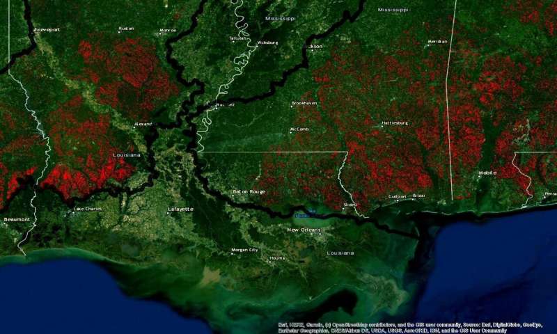
Habitat loss (red areas) for the Red-cockaded woodpecker listed as endangered in the Gulf state region (partial map) Credit: Adam Eichenwald, Tufts University
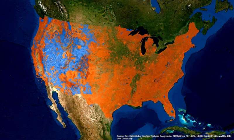
Using more than 30 years of earth satellite images, scientists at Tufts University and the non-profit conservation organization Defenders of Wildlife have discovered that habitat loss for imperiled species in the U.S. over this period was more than twice as great on non-protected private lands than on federally protected lands. As wildlife face a host of survival threats ranging from habitat destruction to global climate change, the study, published today in Frontiers in Ecology and the Environment, provides evidence that federal land protection and listing under the U.S. Endangered Species Act are effective tools for stemming losses in species habitat.
Habitat loss and modification are the primary drivers of global losses in biodiversity, leading to reductions in population size and reproductive rates for many common and endangered . Scientists have worked to identify the most effective mechanisms for preventing future  loss around the globe, yet most studies have had limited geographic scope or focused on only one or a limited range of species.
With a goal of understanding on a national level how land jurisdictions and conservation policies translate to habitat protections on the ground, the study authors collected large scale data on habitat extent across the U.S. for 24 vertebrate species, chosen from among those listed under the Endangered Species Act (ESA) or the International Union for Conservation of Nature's Red List. The species examined have ranges that include both federal and non-federally owned lands, covering 49% of the country from coast to coast and including all major ecosystems in the continental U.S.
Using national databases of wildlife habitat, the researchers mapped out the 24 species' ranges, and tracked habitat change in those ranges over time using the Google Earth Engine LandTrendr algorithm. The data revealed that imperiled species lost the least habitat (3.6%) on federally protected lands and lost the most habitat (8.6%) on  lacking any protections. State lands and lands protected by non-governmental organizations had losses of species habitat similar to one another (4.6% and 4.5%, respectively), but still greater than losses on federal land.
Federally protected lands reduce habitat loss and protect endangered species, study finds
Federally protected lands (light blue) help stem the loss of habitat for endangered species compared to privately held, unprotected lands (orange) Credit: Adam Eichenwald, Tufts University
Since the study covered more than 30 years of data (1986 to 2018), the researchers were also able to observe other residual effects over time, such as the relative impact of protected vs. non-protected lands before and after a species is placed on the ESA or Red List. The authors found evidence that the ESA contributed to habitat protections on federal lands, with species losing less habitat after they were listed than before.
"By zooming out to the national level, the study provided us with a unique opportunity to examine whether certain regulations and jurisdictions were more effective in protecting habitats of ," said Michael Evans, senior conservation data scientist at the Center for Conservation Innovation at Defenders of Wildlife and co-author of the study. "For example, we found that habitat preservation was linked more closely to federal protected land status and ESA protection, regardless of agency-specific regulations. Regulations for protection are different outside of federal lands, where reporting of environmental impacts is required, but minimization of these impacts may not be required."
The authors noted that the differences in how conservation laws and protections are applied in different contexts may not ultimately serve the ESA's intended goal of species preservation. Species not only inhabit federally managed areas, but their ranges can also extend into state and privately-owned land, and even state-owned lands were not as effective as federal lands in protecting species from .
Even if a species' range is contained within federally protected land, that protection can be compromised. "We know from research conducted by other scientists that development surrounding protected areas can reduce the effectiveness of those protections for animals," said Adam Eichenwald, biology graduate student in the laboratory of professor Michael Reed at Tufts and first author of the study. "Not only that, but  can force species to move, which we worry may eventually result in areas designed to protect species without any of their protected occupants."
"At a time when the planet faces a looming extinction crisis, we need every tool available to protect species and their habitats," said Jacob Malcom, director of the Center for Conservation Innovation at Defenders of Wildlife and a co-author on the study. "This research illustrates the critical importance of America's federal lands system for conserving wildlife habitat and the urgent need for better protections on other land ownerships. Biodiversity and the services it provides to society can be conserved through concerted effort and transformative change; protecting habitats must be an essential part of that effort."
Climate change not the only threat to vulnerable species, habitat matters

More information: Adam J Eichenwald et al, US imperiled species are most vulnerable to habitat loss on private lands, Frontiers in Ecology and the Environment (2020). DOI: 10.1002/fee.2177