An unforgettable day in May
The eruption of Mount St. Helens on May 18, 1980, did untold damage and sent volcanic ash over B.C., Alberta and even Saskatchewan. Two Canadians who were nearby share their memories of that fateful day.

May 17, 2020
Rosemary Taylor was nearly finished lacing up her hiking boots at a dusty trailhead in southeastern B.C. when the first distant bang rocked the stillness of the morning.
It was just past 8:30 a.m. on May 18, 1980, the peak of the long weekend, the day already warm beneath a sky of perfect blue.
Moments later, a second boom.
"I thought, that's funny on a quiet Sunday holiday morning," said Taylor, who was 39 at the time.
Her group couldn't think of any quarry or mining activity happening in the area. They paid the noise no more attention and carried on with their hike.
When they reached the viewpoint along the trail hours later, they couldn't see a thing. The sky had gone a foggy grey.

PPE BECAME RARE THEN AS NOW
THE MASK WAS SELLING FOR $1.50
More than 600 kilometres away, Catherine Hickson was cutting her camping trip short and hurtling away from the source of the noise.
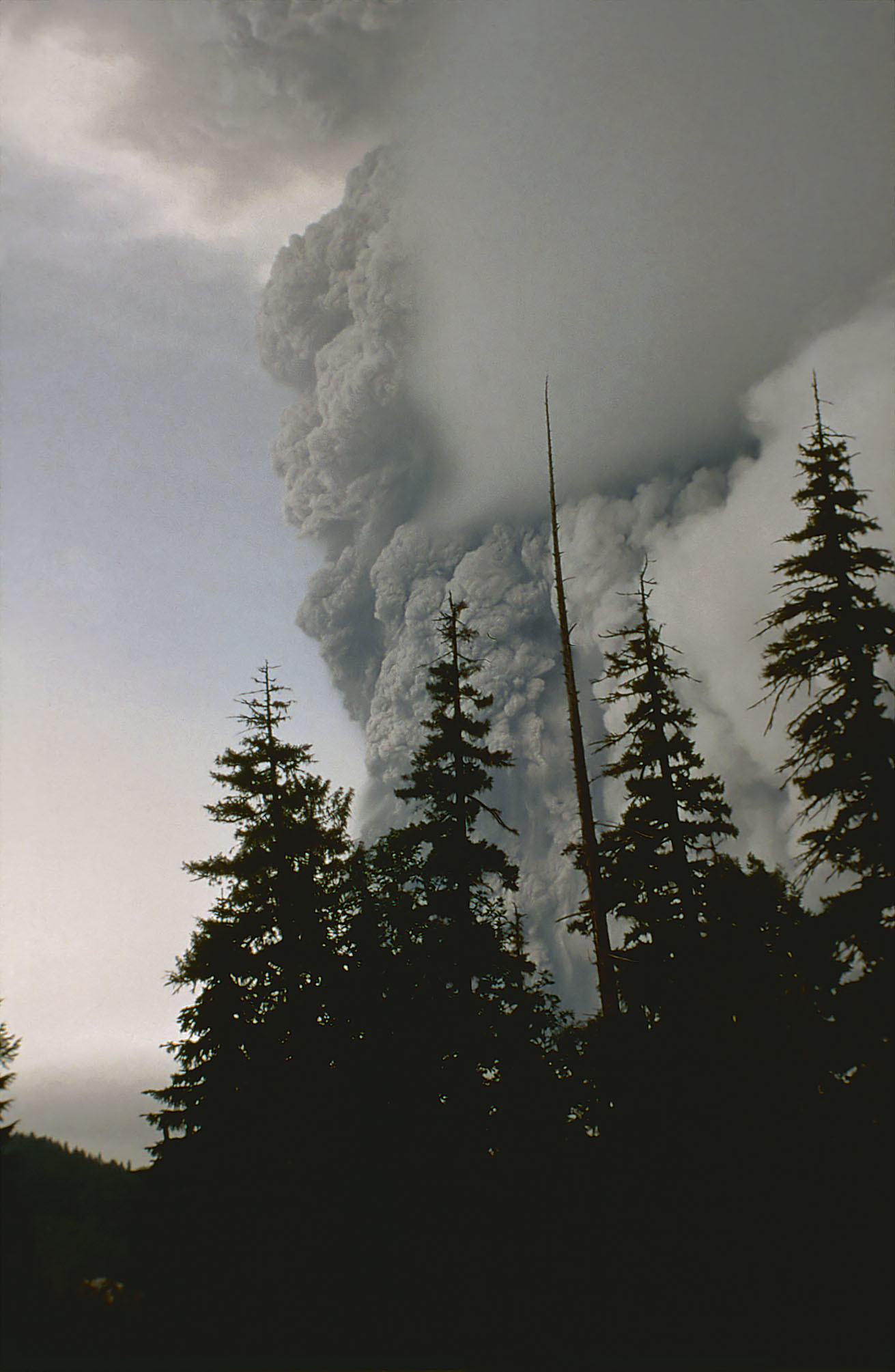
She was hanging out the passenger side of a green Renault station wagon, looking back at an exploding volcano. A third-year geology student, Hickson took photos and told her husband, who was driving, to keep his eyes forward as they roared away down the logging road.
"The first memory is this unbelievable black, seething cloud expanding and just rushing towards us. That's the indelible memory in my eye sockets," said Hickson.
Catherine Hickson took this photo of the eruption as she and her husband raced away from the volcano's base. (Submitted by Catherine Hickson)
The eruption of Mount St. Helens was the deadliest and most destructive of its kind in American history, leaving nearly 60 people missing or dead and destroying more than 250 homes. A torrential landslide wiped out thousands of acres of Washington state forest, leaving a lifeless wasteland in its wake.
The explosion, which struck 40 years ago on Monday, sent pale grey ash as far as southeastern B.C. and parts of Alberta and Saskatchewan.
I WAS GOING TO THE UNIVERSITY OF LETHBRIDGE AND WE GOT COVERED IN ASH I STILL HAVE A CONTAINER OF IT
Hickson, who was 25 at the time and living in Vancouver, had been camping about 14 km east of the volcano base that Victoria Day weekend out of sheer curiosity.
Pressure had been building at Mount St. Helens since mid-March, and geologists across the continent were watching closely.
"Here was an eruption taking place basically in our backyard," said Hickson, who is now 65.
She was sitting in her car, admiring the view of the snow-capped peak after a breakfast of bacon and eggs, when the earth growled.
A chunk of the volcano’s northern face slipped away in a massive landslide at 8:32 a.m. Uncorked, the volcano exploded. Rocks, ash, volcanic gas and steam were hurled high into the air at more than 480 km/h.
A mess of volcanic debris began to gush down the mountainside, obliterating anything in its path.
Hickson was on her feet outside the car.
"At first it was incredibly exciting — like, oh my god ... this is it," Hickson said. "But that massive cloud ... it moved out incredibly rapidly."
Archive footage of Mount St. Helens eruption on May 18, 1980
1:07
CBC Archives footage shows the devastation caused by the eruption on May 18, 1980.
Part of the blast cloud surged over the rim of the newly formed crater and barrelled down the side of the volcano, heading east.
"We could see what we knew were mature Douglas firs basically being enveloped underneath the front of this cloud, in this roiling, boiling mass of ash. It was then that we realized that we were in extreme danger," Hickson said.
The couple rounded up their dogs, sprinted back to the Renault and raced south down the logging road.
"It’s terror, pure fear. [Her husband’s] asking me what's happening and, at that point, I thought, that's the end. This eruption is just going to get bigger and bigger and bigger and we're going to be completely enveloped in it."
The couple escaped. It turned out their campsite had been out of the volcano’s reach. They circled back hours later to retrieve the camping equipment they’d abandoned — they were students and gear was expensive — before heading home to Vancouver.
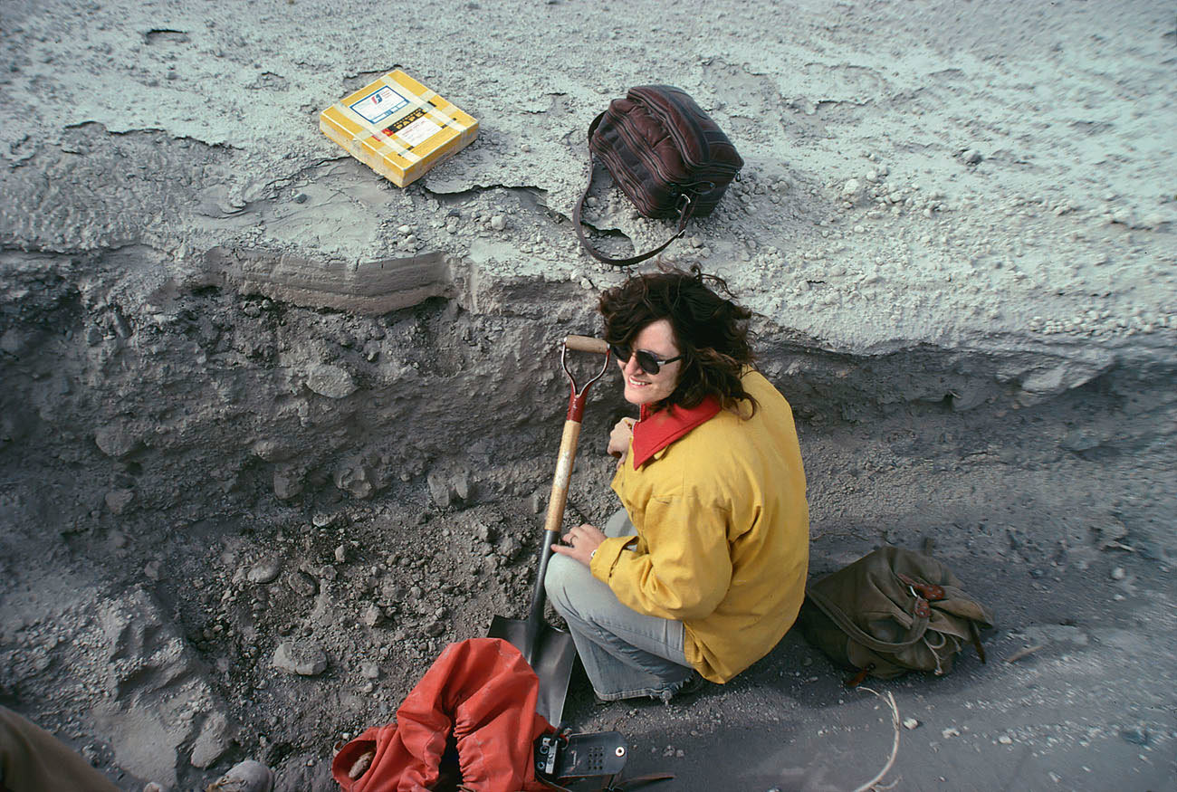
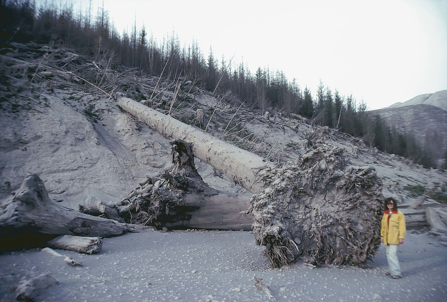
After the explosion, Catherine Hickson returned to the area to assess the damage, at one point standing next to a toppled Douglas fir tree. (Submitted by Catherine Hickson)
Hickson scribbled field notes on scraps of paper in the car during the drive.
At a pit stop late in the afternoon, Hickson called her mother from a payphone to tell her what had happened. The volcano had blown up, Hickson told her, but they were OK and coming home.
Her mother didn’t quite understand until she watched the evening news.
In a subsequent call that night, "my mother gets on the phone and she’s not hysterical but beside herself," said Hickson.
Over on the east coast, 13-year-old Seth Moran was equally transfixed by the news that Sunday.
A self-described "volcano and earthquake nerd," he sat in front of the television in his home in Amherst, Mass., watching his first real-life eruption with equal parts fascination and terror.
Moran grew up to become scientist-in-charge of the U.S. Geological Survey’s Cascades Volcano Observatory, responsible for studying and monitoring volcanoes in the Cascade range of the Pacific northwest.
Moran, now 53, said that over the past 10,000 years, Mount St. Helens has been the most seismically active volcano in the region. It saw a steady eruption period between 1800 and 1857, then a number of smaller eruptions after 1980, most recently in 2004.
If history is an accurate teacher, though, experts don’t expect anything like the 1980 blast to happen again in the near future.
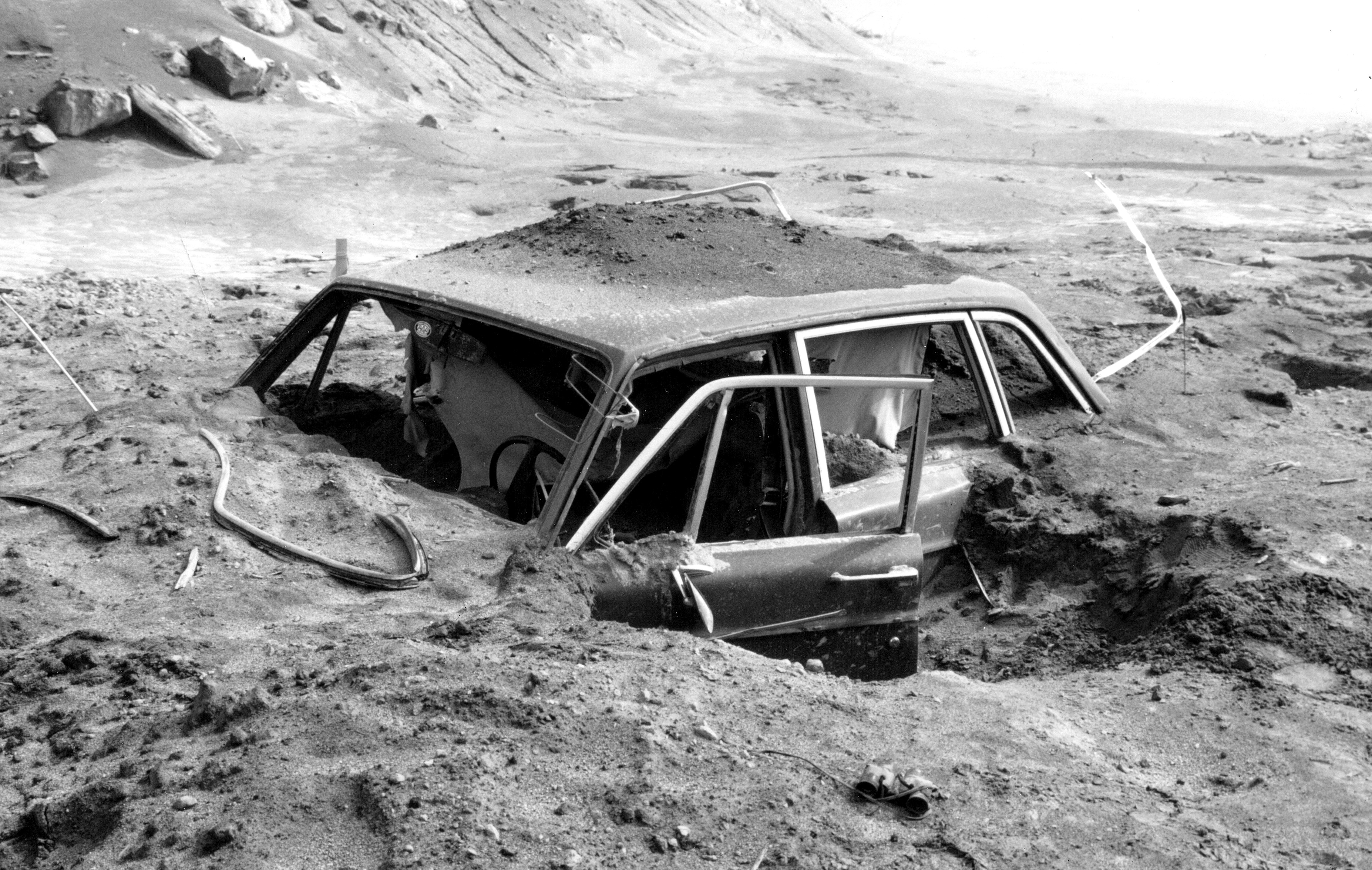
A car more than 10 km northwest of Mount St. Helens' summit lies buried in more than a metre of volcanic ash on May 18, 1980. (U.S. Geological Survey)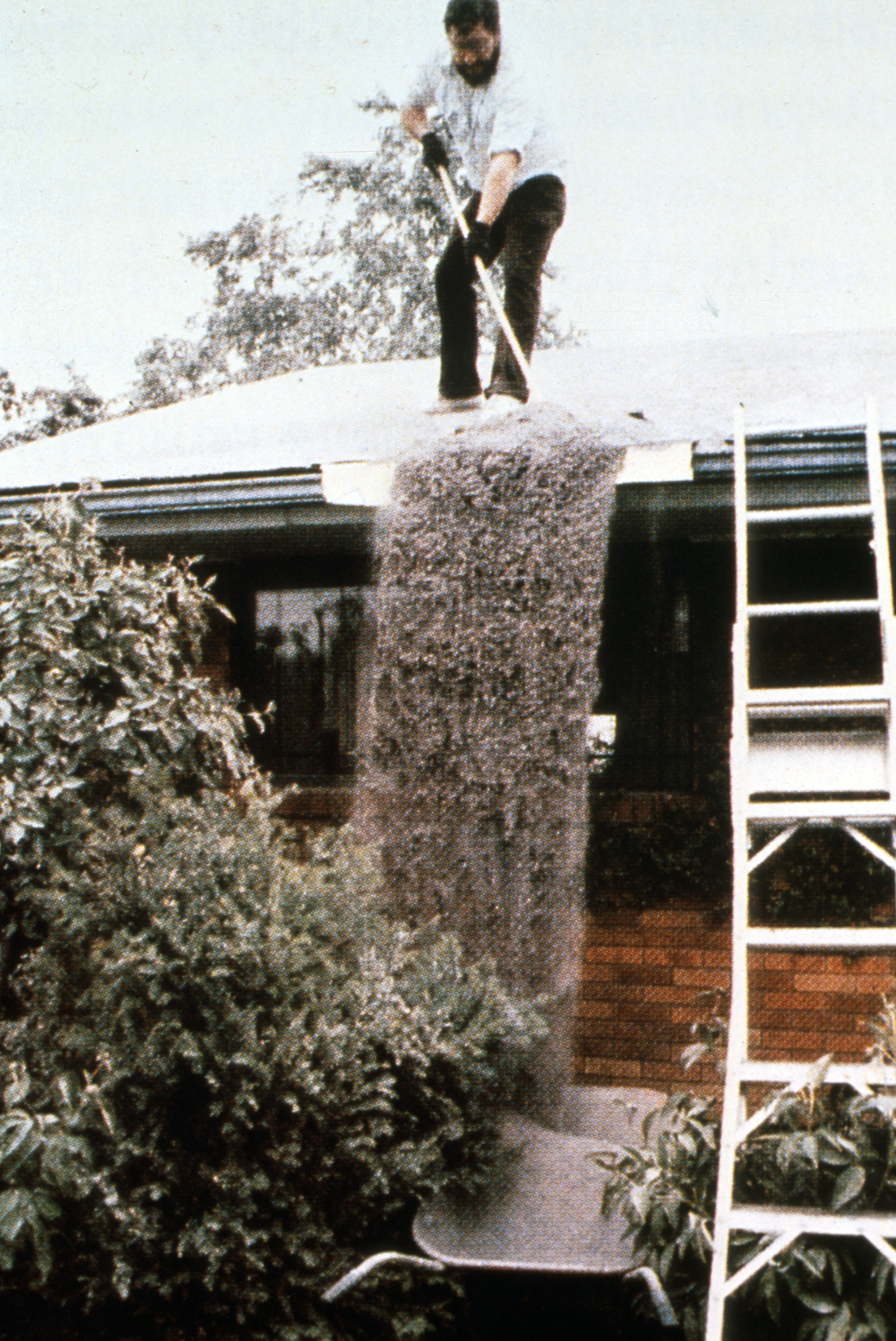
A Washington state resident sweeps ash from the roof of his house on May 18, 1980. (U.S. Geological Survey)
"As a general rule with volcanoes, they blow up big and then there’s a long period of time before they erupt big again," he said.
"We don’t actually know what’s cooking down there … [but] St. Helens does go through those cycles of blowing itself up and then rebuilding, and we’re pretty clearly in a rebuilding phase."
Moran said a landslide of the magnitude of 1980 is unlikely because the chunk of the volcano that slid away back then is still missing.
Today, the Mount St. Helens Visitor Centre in Castle Rock, Wash., offers a straight-shot view, through a webcam, into the crater created in 1980. The surrounding landscape has adapted and regrown and a new ecosystem has taken shape, although hundreds of millions of dollars have been spent to mitigate after-effects of the landslide in the nearby Toutle River.
"There’s a lot of regrowth that’s happened, there’s a lot of vegetation, but from the vantage point of the visitor’s centre, it’s still very fresh and very easy to see what happened back in 1980," Moran said.
To mark the 40-year anniversary of the blast, Hickson participated in two webinars this month with researchers and other witnesses, "to spend a few hours reminiscing."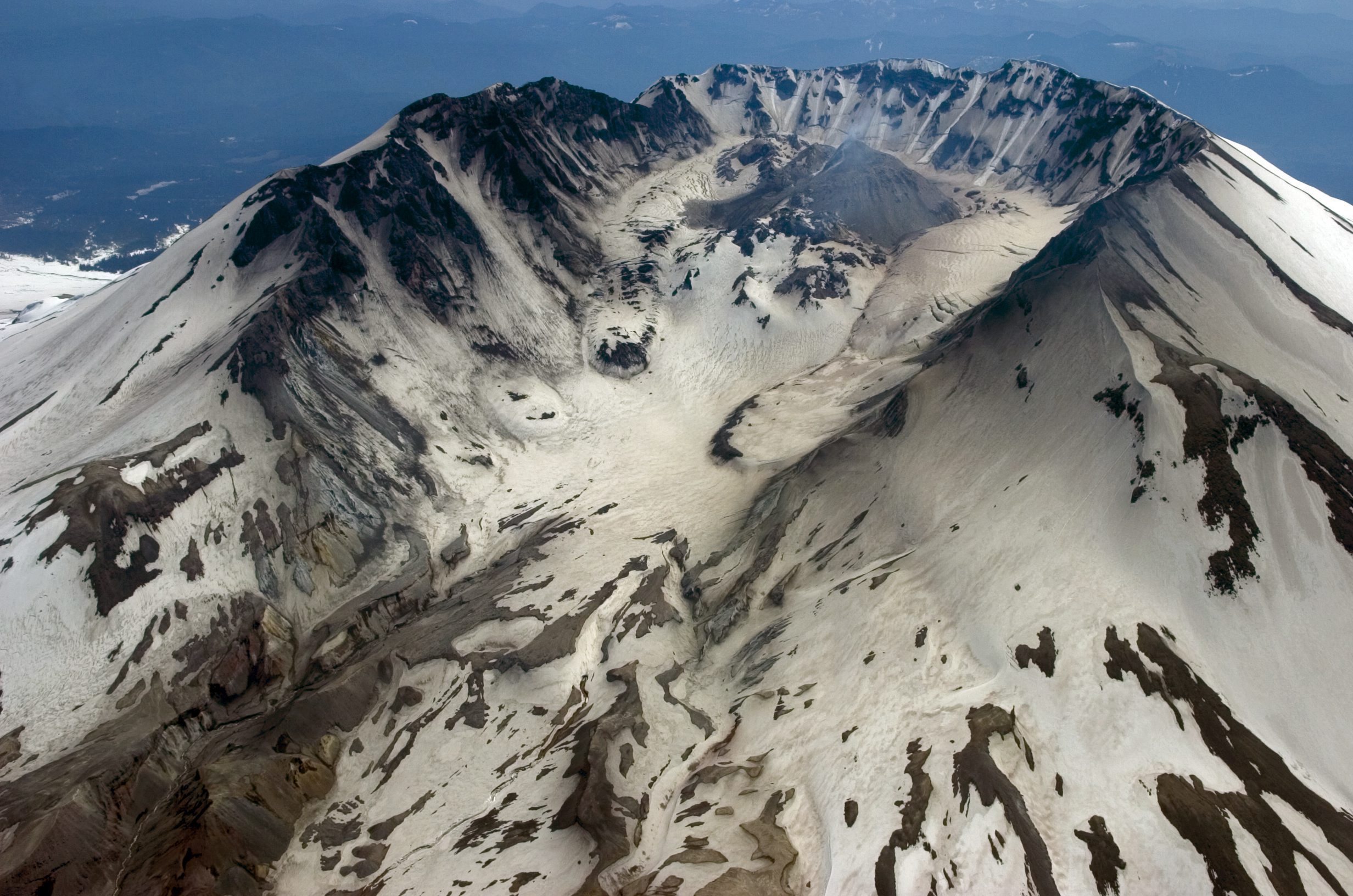
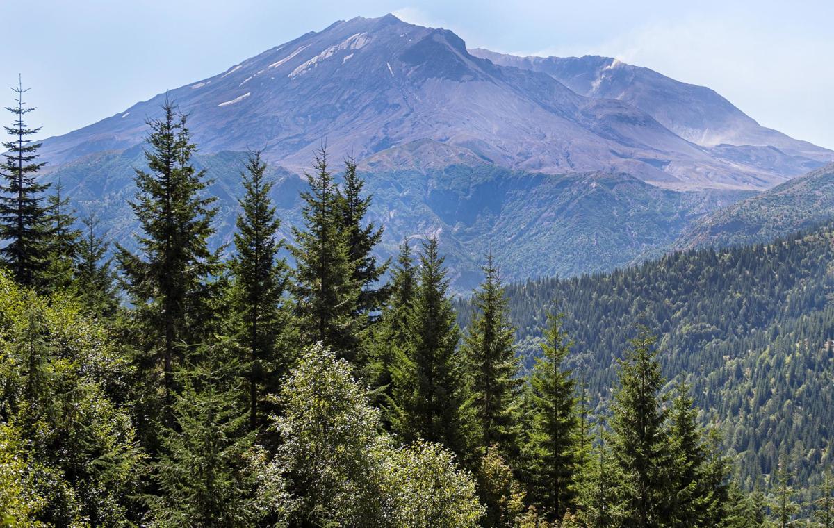
An aerial view of Mount St. Helens in 2006. A chunk of the original volcano is still missing after the 1980 eruption. (AP photo via The Canadian Press)
Like Hickson's mother and teenaged Moran, Rosemary Taylor only learned of the eruption after the evening news aired. That night, two members of her hiking group had gone into town for a meal and returned with the story.
Prior to their trip, "there'd been a bit of discussion that Mount St. Helens was looking a bit dicey ... but who expected those volcanoes to blow up? Come on. They'd been dead for years," said Taylor, now 79.
"Well, dormant," she said, correcting herself. "They're never really dead."
Photos: U.S. Geological Survey; The Associated Press; submitted by Catherine Hickson | Video: CBC Archives | Editing: Andre Mayer
MT ST HELENS BON MOTS
It’s common knowledge that Capt. George Vancouver named Mount St. Helens in 1792 after The 1st Baron of St. Helens, Alleyne FitzHerbert. But who was FitzHerbert, besides being a friend of Vancouver’s? Well, for one thing, he never saw the mountain named after him. But he was well traveled. He was England’s foreign minister to Russia from 1783 to 1788, during the reign of Russian Empress Catherine the Great. He also was foreign minister to Spain from 1790 to 1794. Notably, a lot of the Alaska’s volcanos have Russian names because Russia-sponsored explorers discovered that area startingin the mid 18th century: Davidof, Vsevidof and Veniaminof are among them.
What about the lava dome, or should it be lava domes?
What is known as the lava dome is actually two separate domes: The first was created in successive eruptions starting in October 1980 and continuing periodically through 1986. A second dome, which formed during a continuous eruption from 2004-08, formed just to the south of the first dome and eventually merged with it. The summit of the combined lava dome is at 7,155 feet above sea level — nearly 1,200 feet below the summit — and nearly 900 feet above the 1980 crater floor. It is 3,500 feet in diameter at its base. Its estimated volume, 97 million cubic yards, is enough to cover three lanes of freeway 12 feet deep from Seattle to San Francisco. Two earlier lava domes that formed in June and August 1980 were blasted away by subsequent explosive eruptions.
The ashfall myth
It’s amusing when people say they remember the ashfall in the Kelso-Longview area from the eruption on May 18, 1980. But there was none. All of that ash blew eastward, away from Cowlitz County. It wasn’t until the following Sunday, May 25, 1980, that the county got its first — and only — significant ashfall from the volcano. That eruption occurred during an overnight rainstorm, and the coating of wet ash on power substations caused massive power outages throughout the county.
Was that another eruption?
After the mountain blew so catastrophically, it was common for local people during the summers immediately following the eruption to ask whether giant smoke plumes caused by slash burns — giant fires set to clear logging debris and which are now rare — were eruptions on the east. Landscape-scale slash burns now are largely a thing of the past, but you can count on volcanic eruptions being part of Cowlitz County’s future for millennia.
So how many eruptions have there been since 1980?
Too many to count, really. The mountain had erupted steam, ash and gas for two months before the big blow on May 18, 1980, a period in which its north flank swelled five feet a day. Following May 18, five explosive eruptions later that year sent clouds of ash and steam eight or nine miles into the sky on May 25, June 12, July 22, Aug. 7, and Oct. 16. Quiet “dome building” eruptions continued through October 1986. A period of continuous dome-building occurred from 2004-08. The last explosive eruption of any significance occurred on March 19, 1982. For the last 12 years, the mountain has been largely quiet except for periodic earthquake swarms, which geologists interpret as fresh molten rock moving into the volcano to refuel it for its next eruption. And no one knows when, or how big, it will be. But of all Cascade Range volcanoes, scientists consider Mount St. Helens by far the most likely to erupt next. It’s also rated the second most dangerous volcano in the nation by the USGS, but only because so many people live downvalley of Mount Rainier, which is ranked most dangerous.
Why is that big stack of dredge spoils near the mouth of the Toutle River nicknamed Harry’s Mountain?
Most of what you see of Mount St. Helens is younger than 3,000 years old, which makes it younger than the pyramids in Egypt. And although the volcano’s eruption on May 18, 1980 was dubbed “a worst case scenario,” an eruption that occurred about 3,600 years ago was four times larger, measured by how much ash got blown into the sky.
Related stories

Washington state residents rattled by Mount St. Helens tremors
Over the volcano
Warning signs emerge from the shrinking glacier atop B.C.'s Mount Meage
https://newsinteractives.cbc.ca/longform/mount-meager-eruption-risk


Climate change could wake up Canada's dormant volcanoes

Volcano tourism: Bad idea or a worthy risk-taking adventure
Like Hickson's mother and teenaged Moran, Rosemary Taylor only learned of the eruption after the evening news aired. That night, two members of her hiking group had gone into town for a meal and returned with the story.
Prior to their trip, "there'd been a bit of discussion that Mount St. Helens was looking a bit dicey ... but who expected those volcanoes to blow up? Come on. They'd been dead for years," said Taylor, now 79.
"Well, dormant," she said, correcting herself. "They're never really dead."
Photos: U.S. Geological Survey; The Associated Press; submitted by Catherine Hickson | Video: CBC Archives | Editing: Andre Mayer
MT ST HELENS BON MOTS
First it expanded, now the volcano is shrinking
MOUNT ST HELENS
Shrinking from old age?
Since its 1980 eruption, the summit elevation of Mount St. Helens has decreased. A survey in 1982 gave a measurement of 8,365 feet. However, a lidar survey done in 2009 found the maximum elevation to be 8,330 feet, a full 35 feet lower. The difference in elevation is likely due to erosion and loss of rimrock by collapes of the steep crater-walls, according to the U.S. Geological Survey.
Could the volcano have had a Russian name?
Could the volcano have had a Russian name?
It’s common knowledge that Capt. George Vancouver named Mount St. Helens in 1792 after The 1st Baron of St. Helens, Alleyne FitzHerbert. But who was FitzHerbert, besides being a friend of Vancouver’s? Well, for one thing, he never saw the mountain named after him. But he was well traveled. He was England’s foreign minister to Russia from 1783 to 1788, during the reign of Russian Empress Catherine the Great. He also was foreign minister to Spain from 1790 to 1794. Notably, a lot of the Alaska’s volcanos have Russian names because Russia-sponsored explorers discovered that area startingin the mid 18th century: Davidof, Vsevidof and Veniaminof are among them.
What about the lava dome, or should it be lava domes?
What is known as the lava dome is actually two separate domes: The first was created in successive eruptions starting in October 1980 and continuing periodically through 1986. A second dome, which formed during a continuous eruption from 2004-08, formed just to the south of the first dome and eventually merged with it. The summit of the combined lava dome is at 7,155 feet above sea level — nearly 1,200 feet below the summit — and nearly 900 feet above the 1980 crater floor. It is 3,500 feet in diameter at its base. Its estimated volume, 97 million cubic yards, is enough to cover three lanes of freeway 12 feet deep from Seattle to San Francisco. Two earlier lava domes that formed in June and August 1980 were blasted away by subsequent explosive eruptions.
The ashfall myth
It’s amusing when people say they remember the ashfall in the Kelso-Longview area from the eruption on May 18, 1980. But there was none. All of that ash blew eastward, away from Cowlitz County. It wasn’t until the following Sunday, May 25, 1980, that the county got its first — and only — significant ashfall from the volcano. That eruption occurred during an overnight rainstorm, and the coating of wet ash on power substations caused massive power outages throughout the county.
Was that another eruption?
After the mountain blew so catastrophically, it was common for local people during the summers immediately following the eruption to ask whether giant smoke plumes caused by slash burns — giant fires set to clear logging debris and which are now rare — were eruptions on the east. Landscape-scale slash burns now are largely a thing of the past, but you can count on volcanic eruptions being part of Cowlitz County’s future for millennia.
So how many eruptions have there been since 1980?
Too many to count, really. The mountain had erupted steam, ash and gas for two months before the big blow on May 18, 1980, a period in which its north flank swelled five feet a day. Following May 18, five explosive eruptions later that year sent clouds of ash and steam eight or nine miles into the sky on May 25, June 12, July 22, Aug. 7, and Oct. 16. Quiet “dome building” eruptions continued through October 1986. A period of continuous dome-building occurred from 2004-08. The last explosive eruption of any significance occurred on March 19, 1982. For the last 12 years, the mountain has been largely quiet except for periodic earthquake swarms, which geologists interpret as fresh molten rock moving into the volcano to refuel it for its next eruption. And no one knows when, or how big, it will be. But of all Cascade Range volcanoes, scientists consider Mount St. Helens by far the most likely to erupt next. It’s also rated the second most dangerous volcano in the nation by the USGS, but only because so many people live downvalley of Mount Rainier, which is ranked most dangerous.
Why is that big stack of dredge spoils near the mouth of the Toutle River nicknamed Harry’s Mountain?
No, it is not named after Harry Truman, the 84-year-old lodge owner at Spirit Lake who perished along with his cats on the morning of May 18, 1980. It is named after Harry Claterbos, the Astoria-based contractor who dredged that section of the Cowlitz River under a U.S. Army Corps of Engineers contract following the eruption.
So, just how many volcanoes?
So, just how many volcanoes?
Most people know that Mount St. Helens is a volcano on the “Ring of Fire,” a 25,000-mile long, horseshoe-shaped arc that borders the Pacific Ocean. But just how many volcanoes are located along the ring? Mount St. Helens is one of 452 volcanoes on the Ring of Fire, which contains 75% of the world’s active and dormant volcanoes.
Now that’s a lot of debris
Now that’s a lot of debris
The debris avalanche that toppled off the top and side of Mount St. Helens on May 18, 1980 is considered the largest landslide in recorded history. It was about 16 miles long, contained more than 3 biilion cubic yard of debris, has an average depth of more than 100 feet and is about 600 feet deep at its thickest point. But another landslide off the volcano during its so-called Cougar eruptive stage (28,000 to 18,000 years ago) likely was bigger. That one came off the south side of the volcano. It originated near Butte Camp in the southwest part of the present-day mountain and left a deposit 600 to 900 feet thick and 17 miles long. It temporarily dammed the Lewis River, and when that dam broke it caused flooding downstream as far as the Columbia River and filled the lower Lewis River Valley with volcanic debris at least 200 feet thick, according to the USGS.
What you see today
What you see today
Most of what you see of Mount St. Helens is younger than 3,000 years old, which makes it younger than the pyramids in Egypt. And although the volcano’s eruption on May 18, 1980 was dubbed “a worst case scenario,” an eruption that occurred about 3,600 years ago was four times larger, measured by how much ash got blown into the sky.
Related stories
Washington state residents rattled by Mount St. Helens tremors
Over the volcano
Warning signs emerge from the shrinking glacier atop B.C.'s Mount Meage
https://newsinteractives.cbc.ca/longform/mount-meager-eruption-risk

Climate change could wake up Canada's dormant volcanoes
Volcano tourism: Bad idea or a worthy risk-taking adventure
Autopsies reveal many Mount St. Helens victims suffocated
BOSTON -- Most of the 35 known victims of Mount St. Helens' May 1980 eruption died within minutes from inhaling volcanic ash, and others were 'dried and baked' to death by the blazing heat, autopsy results revealed today.
'The first autopsies were a step into the unknown,' pathologists and medical examiners reported in the New England Journal of Medicine. 'We were unable to find previous references to this type of death in the medical literature, and we had little idea of what to expect.'
The 25 bodies examined were found between 4 to 17 miles from the mountain near Vancouver, Wash., where more than 13 billion gallons of superheated water burst forth as steam on May 18, 1980, carrying fiery volcanic gases and particles into surrounding residential areas.
'The most common cause of death was asphyxia by inhalation of volcanic ash. Seventeen of the deaths were attributed to this cause, and in two more it was contributory,' the examiners said.
The eruption killed at least 62 people who had been camping or sightseeing around the base of the mountain. Thirty-five bodies have been recovered and 27 people are listed as missing and presumed dead.
Many victims were found buried to knees, waist or shoulders in ash. Others weretrapped in vehicles covered by volcanic dust.
The post-mortems were conducted by the King County Medical Examiner's Office in Seattle, Wash., the University of Washington, the University of Oregon and Oregon State Medical Examiner's Office in Portland, Ore.
'The first impression was the all-pervading gray, gritty ash that covered the bodies and their clothing. When incisions were made, the ash dulled scalpel blades within the first few inches.'
The researchers said the ash plugged the lungs of asphyxiation victims in most cases and most of the victims' hands were mummified because of the extreme heat.
Burns accounted for three deaths and contributed to two more. The burns, however, were different from those seen in a fire, the researchers said. The victims, exposed to hot volcanic gases, were 'dried and baked' down to their internal organs.
Three more victims died of other causes, such as being struck by a tree limb, the examiners said.
The examiners said death by asphyxiation probably occurred within minutes -- although there appeared to be time to escape before the ash cloud enveloped the area.
The examiners said it was possible use of disposable dust masks - common after the eruption -- or adequate shelter could have saved lives during the volcano's activity.
But it said, 'For those who were at Spirit Lake at the base of the volcano, one cannot imagine reasonable protective easures.'
No comments:
Post a Comment