
Back then Greenland had a subtropical climate befitting of its name. It was host to volcanic activity that restructured the land and ocean connections and drove rapid warming.
The abrupt global warming event 56 million years ago, known as the Paleocene-Eocene Thermal Maximum (PETM), is often used as a worrying analogue for our current climate crisis.
Our research, published today in Communications Earth and Environment, provides crucial details about the event — with a focus on Greenland’s role in it.
Read more: Volcanic emissions caused the warmest period in past 56m years – new study
Lessons from Earth’s past
About 56 million years ago, increased volcanic activity resulted in the eruption of huge volumes of molten rock, in a vast area surrounding what would eventually become Iceland. Underground, the magma essentially “cooked” sediments rich in organic material, converting the stored carbon into gas.
This led to trillions of tonnes of greenhouse gases being released into the atmosphere. It drove an increase in ocean acidity and a rise in global temperatures to the tune of 5-8℃.
The environmental and ecological consequences were immense. Mass extinctions and animal migrations took place over just a few thousand years. Fast-forward to the release of the latest Intergovernmental Panel on Climate Change report, and there has never been a greater need to understand Earth’s climate systems.
The geological record provides an opportunity to learn from past climate events that occurred on a timescale far longer than human lifespans or any written history.
Most importantly, it could forewarn us of the outcomes of Earth’s current climate upheaval which is unfolding much more rapidly.
Greenland’s exotic land
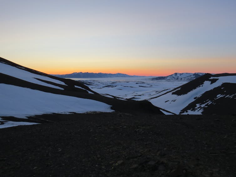
Northeast Greenland is the world’s largest national park, and one of the most remote and unexplored areas on the planet.
For our study, we set out to map the environmental evolution and geographic response to volcanic activity throughout the PETM event in northeast Greenland. Volcanic activity has been identified as the “smoking gun” for what drove the PETM warming.
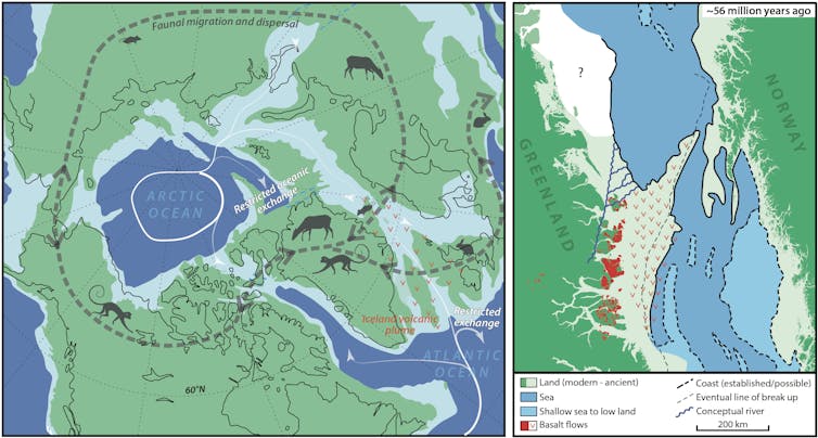
Greenland also acted as a gatekeeper for the once-narrow seaway that connected the Arctic and Atlantic oceans (before movement of the tectonic plates opened the Atlantic more fully).
Greenland therefore played a significant role in regulating climate-critical ocean connections. These channels control the distribution of heat, dissolved gasses such as oxygen and carbon dioxide, nutrients and moisture in the atmosphere.
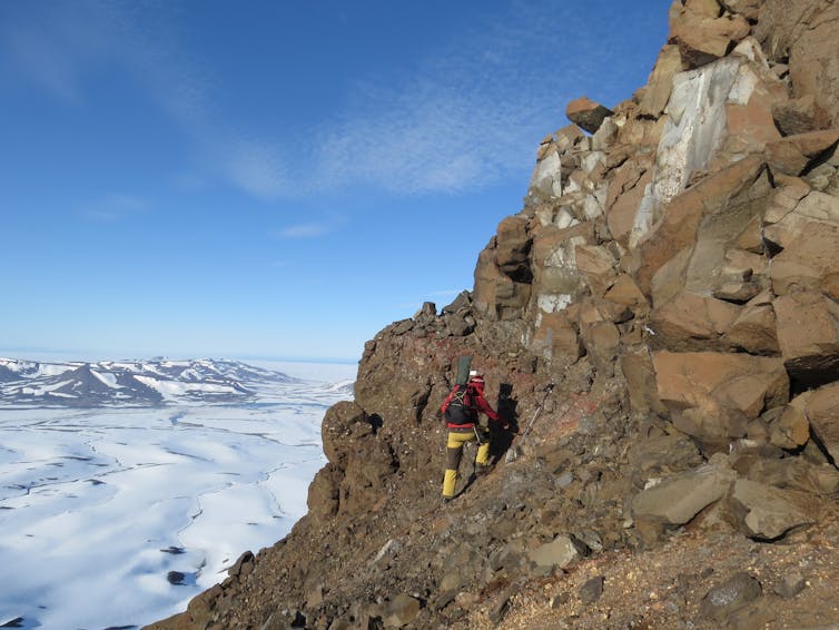
Our international team of geologists carefully mapped sediments and lava flows onshore in northeast Greenland, and in rock cores extracted from the nearby sea bed.
We identified and dated various microscopic plant and plankton fossils, which provided detailed information about the environment they would have lived in. This was combined with findings gleaned from tracing the echoes of sound waves under the seabed.
By measuring how sound waves are reflected by buried sediment, we mapped the thickness and development of the geological layers. This revealed how the landscape, now partly covered by ocean, evolved over time.
With this, we carefully resurrected an image of northeast Greenland as it was between 47 and 63 million years ago.
A hotter, wetter planet
We discovered that around the time of the PETM, volcanic uplift turned deeper marine environments around northeast Greenland into shallow estuaries, rivers and vegetated swampy floodplains.
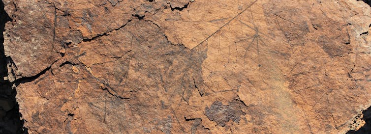
Around 56 million years ago lava began erupting across the region, building volcanic rock piles hundreds of metres high. As successive lava flows emerged, the hot, wet climate of the time eventually caused the surface to break down into a red soil called laterite.
Our data from northeast Greenland are consistent with broader Arctic greenhouse reconstructions of the time. Both paint a picture of lush, swampy woodlands inhabited by cold-blooded reptiles, primates and hippo-like beasts unlike anything you’d see in today’s cooler world.
Ocean gateways and land bridges
Our work also reconstructs seabed uplift, and the emergence of large areas of land from the ocean. This is important as it would have caused a severe obstruction of the seaway that separated Greenland and Norway.
Such blockages are bad news. We know from the geological record that if critical ocean circulation stops, it can lead to dangerously acidic and oxygen-starved oceans, as well as enhanced climate disturbance.
That said, when the flow of water between the Atlantic and Arctic was constricted because of emerging land during the PETM, there was more opportunity for plants and animals to move around. The continental connection allowed species to migrate into cooler climates and escape the effects of the warming
Back to the future
Today’s environments have been largely broken up by human activity through agriculture and urbanisation, which gives species under environmental stress less opportunity to move elsewhere to survive any change.
And although we’re still some way from matching the overall volume of greenhouse gas emissions released during the PETM, today’s emission rates are rising almost ten times faster. Our ecosystems are already displaying signs of destabilisation.
Recent studies have warned of weakening ocean circulation, which may lead to climatic tipping points. Without urgent intervention, the unfolding climate and ecological crisis could prove to be a far greater burden than the world can bear.
Authors

Senior Lecturer, Curtin University

Senior scientist, Geological Survey of Denmark and Greenland

Geological Survey of Denmark and Greenland
Disclosure statement
Milo Barham works is a Senior Lecturer at Curtin University. He has received funding from industry partners and state geoscience bodies. He is affiliated with the Timescales of Mineral Systems Group and The Institute of Geoscience Research at Curtin University.
Jussi Hovikoski works as a Senior Scientist at the Geological Survey of Denmark and Greenland. He has received funding from GEUS, Greenland authorities and industry.
Michael B.W. Fyhn works as Senior Scientist for the Geological Survey of Denmark and Greenland (GEUS). He receives funding from GEUS, Greenlandic Authorities and industry.
Partners
Curtin University provides funding as a member of The Conversation AU.
Rise and fall of water blisters offers glimpse beneath Greenland’s thick ice sheet
IMAGE: A STUDY LED BY PRINCETON UNIVERSITY RESEARCHERS FOUND THAT AS MELTWATER LAKES ON THE SURFACE OF GREENLAND’S ICE SHEET (PICTURED) RAPIDLY DRAIN, THEY CREATE WATER BLISTERS BETWEEN THE ICE AND THE BEDROCK THAT SCIENTISTS COULD USE TO UNDERSTAND THE HYDROLOGICAL NETWORK BELOW GREENLAND’S THICK INLAND ICE SHEET. THESE NETWORKS COULD AFFECT THE STABILITY OF THE ICE SHEET AS EARTH’S CLIMATE WARMS. view more
CREDIT: IMAGE FROM GOOGLE EARTH
Water “blisters” trapped beneath the thick interior of Greenland’s ice sheet could provide critical insight into the hydrological network coursing deep below Earth’s second largest body of ice — and how it might be destabilized by climate change, according to a new study.
Each year, thousands of natural meltwater lakes form on the surface of the ice sheet’s high-elevation interior, where ice can be more than a half-mile thick. As these lakes drain, they form large water-filled cavities between the ice and the bedrock.
By combining field observations with mathematical models and laboratory experiments, Princeton University-led researchers discovered that these blisters push the surface of the ice upward, then cause it to gradually drop down as the water permeates into the subglacial drainage system, according to a report in the journal Nature Communications.
The team shows for the first time that the rise and fall of the ice sheet caused by rapid lake drainages can be used to estimate a property known as transmissivity, which characterizes the efficiency of the water networks that form between the ice and the bedrock. Lake drainage presents a new tool for gauging transmissivity beneath inland regions of the ice sheet, where transmissivity is otherwise difficult to measure, the researchers reported. They found that transmissivity can increase by as much as two orders of magnitude during Greenland’s summer melt season.
The findings could shed light on how climate change will affect Greenland’s vast frozen interior as the planet warms and surface melting increases, said first author Ching-Yao Lai, an assistant professor of geosciences and atmospheric and oceanic sciences at Princeton. Water from surface melting can act as a lubricant, she said, causing the glacier to slide more easily across the bedrock.
Existing research has shown that a major way for surface melting to impact the stability of the Greenland ice sheet is by meltwater lubricating the ice-sheet bed, Lai said. The majority of these studies, however, have focused on low-elevation areas where the ice sheet is thinner. Previous studies also have suggested that increased surface melt could accelerate the velocity of the high-elevation, interior ice sheet, but these findings are based on computational models, rather than observations, Lai said.
The paper in Nature Communications provides a rare, observation-based glimpse into the largely inaccessible water networks underlying Greenland’s high-elevation ice sheet. The study was supported by Princeton’s High Meadows Environmental Institute (HMEI) and the HMEI Carbon Mitigation Initiative.
“We know that as the climate warms in the future, the surface melt zone can expand and migrate to higher elevations than currently observed. A big question that remains to be answered, however, is how much transmissivity can increase further inland,” said Lai, who is an associated faculty member in HMEI.
“A potential impact is that the link between surface melt and subglacial water-network development could be activated not only at lower elevations, as currently observed, but also at higher elevations,” she said. “More observations of seasonal changes of subglacial transmissivity in response to surface melting would be needed to really understand what would happen when melt migrates to higher elevation regions.”
Co-authors of the paper from Princeton are HMEI associated faculty member Howard Stone, Princeton’s Donald R. Dixon ’69 and Elizabeth W. Dixon Professor of Mechanical and Aerospace Engineering and chair of mechanical and aerospace engineering, and Danielle Chase, a graduate student in Stone’s Complex Fluids Group.
The study co-authors also included Laura Stevens, an associate professor of climate and earth surface processes at the University of Oxford who has extensive experience studying lake drainages and ice dynamics. Stevens helped collect the field observations in Greenland with co-authors Mark Behn, an associate professor of earth and environmental sciences at Boston College, and Sarah Das, an associate scientist at Woods Hole Oceanographic Institution. Timothy Creyts from the Lamont-Doherty Earth Observatory at Columbia University also is a co-author on the study.
The researchers used GPS data and field observations of five lake-drainage events that occurred between 2006-12 to estimate drainage volume and to observe surface displacements caused by lake drainage and subsequent blister formation.
“We observed in the GPS data a wide range of ice-sheet uplift relaxation times following the five drainage events,” Stevens said. “We had an inkling that this spread in relaxation times might be indicative of some characteristic of the subglacial drainage system. Our understanding was significantly improved as this collaboration between researchers with expertise in observational, theoretical and experimental approaches catalyzed.”
Chase — who received a HMEI Walbridge Fund Graduate Award to study fluid-driven fracturing — then designed a series of experiments using a type of silicone that mimics the deformable ice overtop a porous material that represents the bedrock. She injected fluid between the deformable sheet and the porous substrate, observing the time it took for a blister to form and then drain into the porous substrate. Working with Stone and Lai, Chase also developed a mathematical model that explains the physics that govern the surface uplift and relaxation due to water blister formation. Her work is the topic of a paper recently accepted by the journal Physical Review Fluids.
“Experiments can be helpful because, in the lab, we can control and measure all the parameters in the system, which allowed us to test our model,” Chase said. “We also can choose ideal materials. The system is small enough to be held in one hand and the material is transparent, so we were able to directly observe the shape of the blister and the drainage into the porous substrate over time.”
The study is unique for using laboratory experiments to investigate natural processes such as blister formation that are difficult to analyze in the field where researchers cannot control the parameters.
“It is valuable to have laboratory models to better understand the mechanisms behind the complex shape changes that occur in nature,” Stone said. “Here, the laboratory experiments captured the main mechanical features observed in the field and helped us understand the relaxation of the ice sheet as water drains along the glacial bed.”
The paper, “Hydraulic transmissivity inferred from ice-sheet relaxation following Greenland supraglacial lake drainages,” was published in Nature Communications. The work was supported by Lamont Postdoctoral Fellowships from the Lamont-Doherty Earth Observatory; a National Science Foundation (NSF) Graduate Research Fellowship; the NSF Office of Polar Programs (OPP-1643970) and Cryospheric Sciences Program (OPP-1838410, ARC-1023364, ARC-0520077, and NNX10AI30G); NASA (NNX16AJ95G); the Vetlesen Foundation; the High Meadows Environmental Institute and the HMEI Carbon Mitigation Initiative at Princeton University; and the Princeton University Library Open Access Fund.
JOURNAL
Nature Communications
METHOD OF RESEARCH
Experimental study
ARTICLE TITLE
Hydraulic transmissivity inferred from ice-sheet relaxation following Greenland supraglacial lake drainages
CAPTION
Meltwater-filled cavities push the surface of the ice sheet upward (left), then cause it to gradually drop down (right) as the water permeates the subglacial drainage system. This rise and fall can be used to estimate a property of the subglacial drainage system known as transmissivity.
CREDIT
Image by Ching-Yao Lai, Department of Geosciences
CAPTION
The study used GPS observations of surface uplift caused by lake drainage events. Above, meltwater lakes on the surface (left) empty through fractures in the ice sheet (right). Water from surface melting can act as a lubricant that loosens the ice sheet’s grip on the ground.
CREDIT
Photos from Sentinel-2 imagery
No comments:
Post a Comment