Annalisa Bracco, Professor of Ocean and Climate Dynamics, Georgia Institute of Technology
Wed, June 21, 2023
THE CONVERSATION

The Indian Ocean's heat is having effects on land, too. NOAA Coral Reef Watch
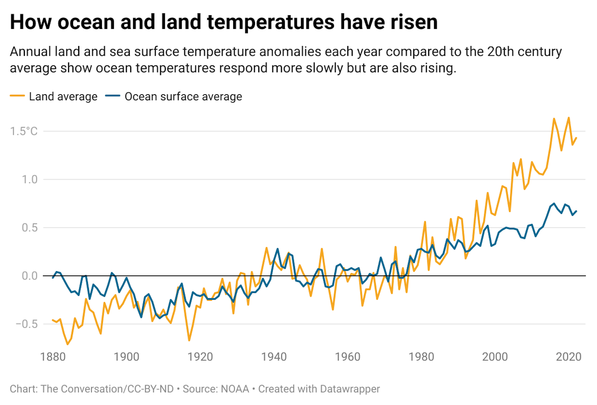
Ocean temperatures have been off the charts since mid-March 2023, with the highest average levels in 40 years of satellite monitoring, and the impact is breaking through in disruptive ways around the world.
The sea of Japan is more than 7 degrees Fahrenheit (4 degrees Celsius) warmer than average. The Indian monsoon, closely tied to conditions in the warm Indian Ocean, has been well below its expected strength.
Spain, France, England and the whole Scandinavian Peninsula are also seeing rainfall far below normal, likely connected to an extraordinary marine heat wave in the eastern North Atlantic. Sea surface temperatures there have been 1.8 to 5 F (1 to 3 C) above average from the coast of Africa all the way to Iceland.
So, what’s going on?
The Indian Ocean's heat is having effects on land, too. NOAA Coral Reef Watch
Ocean temperatures have been off the charts since mid-March 2023, with the highest average levels in 40 years of satellite monitoring, and the impact is breaking through in disruptive ways around the world.
The sea of Japan is more than 7 degrees Fahrenheit (4 degrees Celsius) warmer than average. The Indian monsoon, closely tied to conditions in the warm Indian Ocean, has been well below its expected strength.
Spain, France, England and the whole Scandinavian Peninsula are also seeing rainfall far below normal, likely connected to an extraordinary marine heat wave in the eastern North Atlantic. Sea surface temperatures there have been 1.8 to 5 F (1 to 3 C) above average from the coast of Africa all the way to Iceland.
So, what’s going on?

Sea surface temperatures are running well above the average since satellite monitoring began. The thick black line is 2023. The orange line is 2022. The 1982-2011 average is the middle dashed line. ClimateReanalyzer.org/NOAA OISST v2.1
El Niño is partly to blame. This climate phenomenon, now developing in the equatorial Pacific Ocean, is characterized by warm waters in the central and eastern Pacific, which generally weakens the trade winds in the tropics. This weakening of those winds can affect oceans and land around the world.
But there are other forces at work on ocean temperatures.
Underlying everything is global warming – the continuing rising trend of sea surface and land temperatures for the past several decades as human activities have increased greenhouse gas concentrations in the atmosphere.
The world just came off three straight years of La Niña – El Niño’s opposite, characterized by cooler waters rising in the equatorial Pacific. La Niña has a cooling effect globally that helps keep global sea surface temperatures in check but can also mask global warming. With that cooling effect turned off, the heat is increasingly evident.
Arctic sea ice was also unusually low in May and early June, and it may play a role. Losing ice cover can increase water temperatures, because dark open water absorbs solar radiation that white ice had reflected back into space.
These influences are playing out in various ways around the world.
The effects of extraordinary Atlantic heat
In early June 2023, I visited the NORCE climate center in Bergen, Norway, for two weeks to meet with other ocean scientists. The warm waters and mild winds across the eastern North Atlantic brought a long stretch of sunny, warm weather in a month when more than 70% of days normally would have been downpours.
The whole agricultural sector of Norway is now bracing for a drought as bad as the one in 2018, when yield was 40% below normal. Our train from Bergen to Oslo had a two-hour delay because the brakes of one car overheated and the 90 F (32 C) temperatures approaching the capital were too high to allow them to cool down.
Many scientists have speculated on the causes of the eastern North Atlantic’s unusually high temperatures, and several studies are underway.
Weakened winds caused the Azores high, a semi-permanent high pressure system over the Atlantic that affects Europe’s weather, to be especially weak and brought less dust from the Sahara over the ocean during the spring, which may have increased the amount of solar radiation reaching the water. A decrease in human-produced aerosol emissions in Europe and in the United States over the past few years – which has succeeded in improving air quality – may also have reduced the cooling effect such aerosols have.
A weakened monsoon in South Asia
In the Indian Ocean, El Niño tends to cause a warming of the water in April and May that can dampen the crucial Indian monsoon.
That may be happening – the monsoon was much weaker than normal from mid-May to mid-June 2023. That can be a problem for a large part of South Asia, where most of the agriculture is still rain-fed and depends heavily on the summer monsoon.

India saw sweltering temperatures in May and June 2023.
Sanjeev Verma/Hindustan Times via Getty Images
The Indian Ocean also saw an intense, slow-moving cyclone in the Arabian Sea this year that deprived land of moisture and rainfall for weeks. Studies suggest storms can sit for longer over warmer waters, gaining strength and pulling moisture to their core, and that can deprive surrounding land masses of water, increasing the risk of droughts, wildfires and marine heat waves.
The Indian Ocean also saw an intense, slow-moving cyclone in the Arabian Sea this year that deprived land of moisture and rainfall for weeks. Studies suggest storms can sit for longer over warmer waters, gaining strength and pulling moisture to their core, and that can deprive surrounding land masses of water, increasing the risk of droughts, wildfires and marine heat waves.
North American hurricane season up in the air
In the Atlantic, the weakening trade winds with El Niño tend to tamp down hurricane activity, but warm Atlantic temperatures can supercharge those storms. Whether the ocean heat, if it persists into fall, will override El Niño’s effects remains to be seen.
Risk of marine heat waves in South America
Marine heat waves can also have huge impacts on marine ecosystems, bleaching coral reefs and causing the death or movement of entire species. Coral-based ecosystems are nurseries for fish that provide food for 1 billion people around the world.
The reefs of the Galapagos Islands and those along the coastlines of Colombia, Panama and Ecuador are already at risk of severe bleaching and mortality from this year’s El Nino. Meanwhile, the Japan Sea and the eastern Mediterranean Sea are both losing their biodiversity to invasive species – giant jellyfish in Asia and lionfish in the Mediterranean – that can thrive in warmer waters.
These kinds of risks are increasing
Spring 2023 was exceptional, with several chaotic weather events accompanying the formation of El Niño and the exceptionally warmer temperatures in many parts of the world. At the same time, the warming of the oceans and atmosphere increase the chances for this kind of ocean warming.
To lower the risk, the world needs to reduce baseline warming by limiting excess greenhouse gas emissions, like fossil fuels, and move to a carbon-neutral planet. People will have to adapt to a warming climate in which extreme events are more likely and learn how to mitigate their impact.
This article is republished from The Conversation, an independent nonprofit news site dedicated to sharing ideas from academic experts.
It was written by: Annalisa Bracco, Georgia Institute of Technology.
Read more:
El Niño is coming, and ocean temps are already at record highs – that can spell disaster for fish and corals
Coral reefs are dying as climate change decimates ocean ecosystems vital to fish and humans
Annalisa Bracco receives funding from NSF, NOAA, DOE.
‘Unprecedented’ ocean heat wave could linger through fall
Denise Chow
Wed, June 21, 2023
An intense marine heat wave that has fueled record-warm sea surface temperatures in the world’s oceans in recent months could linger well into the fall, according to an experimental forecast produced by scientists at the National Oceanic and Atmospheric Administration.
Researchers with the agency’s Physical Sciences Laboratory said unusually warm conditions in the North Atlantic are all but certain to last all summer, with an up to 90% chance that the marine heat wave will persist through November.
Members of the research team are set to host a public discussion later this week to unveil the new forecast and talk about its implications.
Dillon Amaya, a research scientist at NOAA’s Physical Sciences Laboratory, called the situation in the North Atlantic “unprecedented,” adding that researchers have been trying to understand what is driving the current warm spell and its potential consequences.
“There’s only a few things that can cause the ocean to warm so much so quickly,” he said. “The main driver of ocean temperature changes like these are changes in the atmospheric circulation, and if you look at what the atmosphere has been doing over the North Atlantic in the last three months, you’ll see that the circulation has actually been fairly sluggish in that part of the world.”
Typically, there is a subtropical high-pressure system that sits over the North Atlantic that governs surface winds over that region of the planet. When those winds are weaker than normal, ocean temperatures tend to heat up, Amaya said.
But what is causing the weakening has been less clear, he added.
The consequences of such a prolonged warm spell have many scientists worried.
In addition to fueling extreme weather, warmer-than-usual ocean temperatures can accelerate the loss of polar ice, which in turn can exacerbate rising sea levels.
“This is a really startling global situation because the additional surface heating we see at this time will eventually be mixed into the ocean water column,” Craig Donlon, head of the European Space Agency's Earth Surfaces and Interior Section, said in a statement. “Some of this excess heat will find its way into the Arctic Ocean via ocean currents through the Fram Strait and Norwegian Sea further exacerbating the demise of Arctic sea ice.”
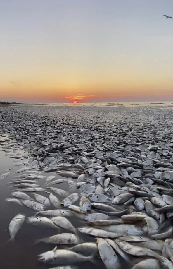
Thousands of dead fish washed ashore in Freeport, Texas on June 9, 2023.
Denise Chow
Wed, June 21, 2023
An intense marine heat wave that has fueled record-warm sea surface temperatures in the world’s oceans in recent months could linger well into the fall, according to an experimental forecast produced by scientists at the National Oceanic and Atmospheric Administration.
Researchers with the agency’s Physical Sciences Laboratory said unusually warm conditions in the North Atlantic are all but certain to last all summer, with an up to 90% chance that the marine heat wave will persist through November.
Members of the research team are set to host a public discussion later this week to unveil the new forecast and talk about its implications.
Dillon Amaya, a research scientist at NOAA’s Physical Sciences Laboratory, called the situation in the North Atlantic “unprecedented,” adding that researchers have been trying to understand what is driving the current warm spell and its potential consequences.
“There’s only a few things that can cause the ocean to warm so much so quickly,” he said. “The main driver of ocean temperature changes like these are changes in the atmospheric circulation, and if you look at what the atmosphere has been doing over the North Atlantic in the last three months, you’ll see that the circulation has actually been fairly sluggish in that part of the world.”
Typically, there is a subtropical high-pressure system that sits over the North Atlantic that governs surface winds over that region of the planet. When those winds are weaker than normal, ocean temperatures tend to heat up, Amaya said.
But what is causing the weakening has been less clear, he added.
The consequences of such a prolonged warm spell have many scientists worried.
In addition to fueling extreme weather, warmer-than-usual ocean temperatures can accelerate the loss of polar ice, which in turn can exacerbate rising sea levels.
“This is a really startling global situation because the additional surface heating we see at this time will eventually be mixed into the ocean water column,” Craig Donlon, head of the European Space Agency's Earth Surfaces and Interior Section, said in a statement. “Some of this excess heat will find its way into the Arctic Ocean via ocean currents through the Fram Strait and Norwegian Sea further exacerbating the demise of Arctic sea ice.”
Thousands of dead fish washed ashore in Freeport, Texas on June 9, 2023.
(Darrell Schoppe / Cover Images via AP)
Marine heat waves can also affect the availability of food for sea creatures, alter migration patterns and devastate marine ecosystems, including coral reefs and fisheries.
Earlier this month, thousands of dead fish washed up on a Gulf Coast beach in a "fish kill" that officials linked to rising ocean temperatures that caused oxygen levels to plunge.
Scientists closely track changes in atmospheric circulation and ocean temperatures because both can influence local climates and extreme weather.
In a June 16 blog post, the United Kingdom’s Met Office, the country’s national weather service, said the record-breaking global sea surface temperatures were the result of “the classic combination of the underpinning of human-caused climate change with a layer of natural variation within the climate system on top.”
The European Space Agency said Tuesday that the waters off the coast of the U.K. and Ireland have been particularly warm, with parts of the North Sea nearly 10 degrees Fahrenheit (5 degrees Celsius) higher than normal for this time of year. Conditions in the Baltic Sea have been even more extreme, the agency said, with sea surface temperatures more than 14 degrees F (8 degrees C) warmer than average.
Oceans naturally absorb and store heat, which can make them important bellwethers of global warming. Studies have found that oceans have absorbed more than 90% of the heat trapped on Earth from greenhouse gas emissions since 1970.
Amaya said that it's too soon to tease out the specific fingerprints of climate change on this marine heat wave.
The return of El Niño, a naturally occurring climate pattern, also adds to concerns that the world’s oceans will remain exceptionally warm in the coming months.
El Niño occurs when changes in the strength or direction of trade winds cause waters in the central and eastern tropical Pacific Ocean to become warmer than usual. These shifts have a strong influence on global temperatures and extreme weather, including rainfall, hurricanes and other severe storms.
Amaya said he hopes the new forecast will be a valuable tool to help the public better understand marine heat waves. He also said it's a unique opportunity for scientists to study the consequences of such a pronounced anomaly.
“I’m certainly not excited for the impacts,” he said, “but I’m excited and curious to learn more about what’s going on from an intellectual and scientific perspective.”
This article was originally published on NBCNews.com
North Atlantic temperatures are breaking records. What does it mean?
Scott Sutherland
Tue, June 20, 2023

Sea surface temperatures in the North Atlantic Ocean are significantly higher now than they have been at any time in the past 42 years. What’s going on, and what impact might this have on this year’s Atlantic Hurricane Season?
Ocean temperatures have been running high ever since March, and the end of the La Niña pattern that had persisted for the past two and a half years. It was expected that the global average temperature would rise as the wide cool region of Pacific ocean surface during La Niña transitioned to warmer waters with the development of a new El Niño. However, a somewhat unexpected response was seeing the North Atlantic Ocean break temperature records over that same time period.
The situation is unprecedented. Since March 5, 2023, the average sea surface temperature of the North Atlantic has been breaking records, reaching a high of 23.1°C as of June 18. Never before in the over 42 years of record keeping have North Atlantic sea surface temperatures reached this high.

North-Atlantic-SST-18062023-ClimateReanalyzer
North Atlantic sea surface temperatures for year-to-date 2023 are shown in the above graph as a solid black line. Temperatures reached an average of 23.1C on June 18, 2023. That’s a half of a degree Celsius warmer than the previous record on that date, set back in 2010. (Climate Reanalyzer/Climate Change Institute at the University of Maine)
According to Brian McNoldy, a senior research associate at the University of Miami Rosenstiel School, the chances of global sea surface temperatures reaching as high as they are now, simply by chance, is only 1 in 256,000.
“This is beyond extraordinary,” McNoldy said on Twitter.
Impacts of this heat
Besides the implications for climate change and sea level rise, these extreme ocean temperatures are having local impacts on ocean wildlife.
One example is the thousands of dead fish that washed up on Texas shorelines over the past few weeks.
The reason for this comes down to the amount of oxygen available in the water. Calm waters and cloudy skies apparently contributed to this fish kill. According to the Quintana Beach County Park, which is one of the beaches affected by this fish kill, the cloudy skies reduced the amount of sunlight available to microscopic phytoplankton, which produce some of the oxygen that gets dissolved in the water, and the lack of waves limited how much oxygen was captured by the ocean surface due to wave action.
The warmer waters played a significant role, though, as oxygen levels in the water drop as the temperature rises.
"Water can only hold so much oxygen at certain temperatures, and certainly we know that seawater temperatures are rising," Katie St. Clair, the manager of the sea life facility at Texas A&M University at Galveston told NPR. "It is concerning and something that needs to be monitored."
A similar situation is also brewing off the coasts of Ireland and the United Kingdom.
2023's Atlantic Hurricane Season
Another particular area of concern here is the Atlantic Main Development Region, which is where most North Atlantic tropical storms and hurricanes form.
According to Ben Noll, a meteorologist with New Zealand’s National Institute of Water & Atmospheric Research, temperatures in this area of the Atlantic are record high right now.
With hotter sea surface temperatures in the Main Development Region, there comes a greater risk of powerful tropical cyclones spinning up.
“The MDR, a breeding ground for hurricanes, has an average temperature of 28˚C (82˚F), surpassing the previous record that was set in 2005,” Noll said. “2005 featured the second most active hurricane season on record. 2023 appears unlikely to be that active because of El Niño, but a busy season is well within the realm of possibility.”
As noted by Noll, with the newly-developed El Niño in the equatorial Pacific Ocean, there will be a tendency towards weaker tropical cyclones across the North Atlantic. During an El Niño, winds high above the Atlantic typically blow stronger than they do when there’s a La Niña pattern or when conditions are “in between” El Niño and La Niña. That has the effect of limiting how tall a tropical cyclone can grow, which in turn limits how strong the storm can become. Thus, El Niño years tend to have slightly weaker hurricane seasons, overall.
Such is not always the case, though. The 2005 Atlantic Hurricane Season occurred during a weak to moderate El Niño, and it still produced a total of 28 storms. From 2005 to 2019, it remained the most active hurricane season on record, and it still holds the record for the greatest number of hurricanes (15) and the greatest number of major hurricanes (7), which included four Category 5 storms — Emily, Katrina, Rita, and Wilma.
Towards the end of May, NOAA issued their outlook for the 2023 Atlantic hurricane season, forecasting a 40 per cent chance of a near-normal year for tropical storms and hurricanes. Their forecast is calling for between 12-17 named storms to develop before the season ends on November 30. Of those storms, between 5 and 9 are expected to become hurricanes, and up to 4 of those hurricanes could develop into major hurricanes (Category 3 or higher). Due to the uncertainties in how long these record-breaking ocean temperatures will last and how quickly El Niño will develop, the other 60 per cent confidence was evenly split with regards to whether this could end up as a “below average” or “above average” season.

Two-Day Atlantic June 20 2023 NHC
(NOAA/NWS National Hurricane Center)
Even up until the middle of June, the only storm detected was Tropical Storm Arlene, which developed and then died off after only three days in the Gulf of Mexico.
However, as of June 19, activity is ramping up. The NWS’s National Hurricane Center is already tracking Tropical Storm Bret in the mid-Atlantic. Another disturbance (indicated by the “1” on the above satellite image) has a 70 per cent chance of developing into a tropical cyclone in the 48 hours after this article was published.
It remains to be seen exactly how Bret and this potential cyclone develop, but activity is definitely increasing and this could be a sign of a fairly active season ahead.
(Thumbnail courtesy Climate Reanalyzer/Climate Change Institute at the University of Maine)
Watch below: Climate change is turning summer into a real bummer
Click here to view the video
Scott Sutherland
Tue, June 20, 2023
Sea surface temperatures in the North Atlantic Ocean are significantly higher now than they have been at any time in the past 42 years. What’s going on, and what impact might this have on this year’s Atlantic Hurricane Season?
Ocean temperatures have been running high ever since March, and the end of the La Niña pattern that had persisted for the past two and a half years. It was expected that the global average temperature would rise as the wide cool region of Pacific ocean surface during La Niña transitioned to warmer waters with the development of a new El Niño. However, a somewhat unexpected response was seeing the North Atlantic Ocean break temperature records over that same time period.
The situation is unprecedented. Since March 5, 2023, the average sea surface temperature of the North Atlantic has been breaking records, reaching a high of 23.1°C as of June 18. Never before in the over 42 years of record keeping have North Atlantic sea surface temperatures reached this high.
North-Atlantic-SST-18062023-ClimateReanalyzer
North Atlantic sea surface temperatures for year-to-date 2023 are shown in the above graph as a solid black line. Temperatures reached an average of 23.1C on June 18, 2023. That’s a half of a degree Celsius warmer than the previous record on that date, set back in 2010. (Climate Reanalyzer/Climate Change Institute at the University of Maine)
According to Brian McNoldy, a senior research associate at the University of Miami Rosenstiel School, the chances of global sea surface temperatures reaching as high as they are now, simply by chance, is only 1 in 256,000.
“This is beyond extraordinary,” McNoldy said on Twitter.
What’s going on here?
There is undoubtedly a human component to this. As greenhouse gas emissions continue to rise, more heat is being trapped in Earth’s climate system, and a significant portion of that heat is going into the oceans. There are other factors contributing to it, though.
One is Saharan dust, or in this case, the lack of it.
Easterly winds blowing off the Sahara Desert carry dust particles out over the ocean. Depending on the specific conditions, this dust can form a thick layer that’s easily visible from space. At times, it can even travel straight across the ocean to impact air quality along the east coast of North America.
When this dust is present, the particles reflect sunlight back into space, thus keeping the ocean surface slightly cooler.
However, when dust concentrations are very low, as they are now, more sunlight reaches the ocean unimpeded and the surface heats up more than usual.
Impacts of this heat
Besides the implications for climate change and sea level rise, these extreme ocean temperatures are having local impacts on ocean wildlife.
One example is the thousands of dead fish that washed up on Texas shorelines over the past few weeks.
The reason for this comes down to the amount of oxygen available in the water. Calm waters and cloudy skies apparently contributed to this fish kill. According to the Quintana Beach County Park, which is one of the beaches affected by this fish kill, the cloudy skies reduced the amount of sunlight available to microscopic phytoplankton, which produce some of the oxygen that gets dissolved in the water, and the lack of waves limited how much oxygen was captured by the ocean surface due to wave action.
The warmer waters played a significant role, though, as oxygen levels in the water drop as the temperature rises.
"Water can only hold so much oxygen at certain temperatures, and certainly we know that seawater temperatures are rising," Katie St. Clair, the manager of the sea life facility at Texas A&M University at Galveston told NPR. "It is concerning and something that needs to be monitored."
A similar situation is also brewing off the coasts of Ireland and the United Kingdom.
2023's Atlantic Hurricane Season
Another particular area of concern here is the Atlantic Main Development Region, which is where most North Atlantic tropical storms and hurricanes form.
According to Ben Noll, a meteorologist with New Zealand’s National Institute of Water & Atmospheric Research, temperatures in this area of the Atlantic are record high right now.
With hotter sea surface temperatures in the Main Development Region, there comes a greater risk of powerful tropical cyclones spinning up.
“The MDR, a breeding ground for hurricanes, has an average temperature of 28˚C (82˚F), surpassing the previous record that was set in 2005,” Noll said. “2005 featured the second most active hurricane season on record. 2023 appears unlikely to be that active because of El Niño, but a busy season is well within the realm of possibility.”
As noted by Noll, with the newly-developed El Niño in the equatorial Pacific Ocean, there will be a tendency towards weaker tropical cyclones across the North Atlantic. During an El Niño, winds high above the Atlantic typically blow stronger than they do when there’s a La Niña pattern or when conditions are “in between” El Niño and La Niña. That has the effect of limiting how tall a tropical cyclone can grow, which in turn limits how strong the storm can become. Thus, El Niño years tend to have slightly weaker hurricane seasons, overall.
Such is not always the case, though. The 2005 Atlantic Hurricane Season occurred during a weak to moderate El Niño, and it still produced a total of 28 storms. From 2005 to 2019, it remained the most active hurricane season on record, and it still holds the record for the greatest number of hurricanes (15) and the greatest number of major hurricanes (7), which included four Category 5 storms — Emily, Katrina, Rita, and Wilma.
Towards the end of May, NOAA issued their outlook for the 2023 Atlantic hurricane season, forecasting a 40 per cent chance of a near-normal year for tropical storms and hurricanes. Their forecast is calling for between 12-17 named storms to develop before the season ends on November 30. Of those storms, between 5 and 9 are expected to become hurricanes, and up to 4 of those hurricanes could develop into major hurricanes (Category 3 or higher). Due to the uncertainties in how long these record-breaking ocean temperatures will last and how quickly El Niño will develop, the other 60 per cent confidence was evenly split with regards to whether this could end up as a “below average” or “above average” season.
Two-Day Atlantic June 20 2023 NHC
(NOAA/NWS National Hurricane Center)
Even up until the middle of June, the only storm detected was Tropical Storm Arlene, which developed and then died off after only three days in the Gulf of Mexico.
However, as of June 19, activity is ramping up. The NWS’s National Hurricane Center is already tracking Tropical Storm Bret in the mid-Atlantic. Another disturbance (indicated by the “1” on the above satellite image) has a 70 per cent chance of developing into a tropical cyclone in the 48 hours after this article was published.
It remains to be seen exactly how Bret and this potential cyclone develop, but activity is definitely increasing and this could be a sign of a fairly active season ahead.
(Thumbnail courtesy Climate Reanalyzer/Climate Change Institute at the University of Maine)
Watch below: Climate change is turning summer into a real bummer
Click here to view the video
The North Atlantic is experiencing a ‘totally unprecedented’ marine heat wave

Climate Change Institute/University of Maine
Laura Paddison
Climate Change Institute/University of Maine
Laura Paddison
CNN
Tue, June 20, 2023
Temperatures in parts of the North Atlantic Ocean are soaring off the charts, with an “exceptional” marine heat wave happening off the coasts of the United Kingdom and Ireland, sparking concerns about impacts on marine life.
Parts of the North Sea are experiencing a category 4 marine heat wave – defined as “extreme” – according to the National Oceanic and Atmospheric Administration. In some areas, water temperatures are up to 5 degrees Celsius (9 Fahrenheit) hotter than usual.
Global oceans have been exceptionally warm for months. April and May saw the highest ocean surface temperatures for those two months since records began in 1850.
The regional picture is even more stark, according to the UK Met Office: Temperatures in the North Atlantic in May were around 1.25 degrees Celsius (2.25 Fahrenheit) above average.
“The eastern Atlantic, from Iceland down to the tropics, is much warmer than average. But areas around parts of north-western Europe, including parts of the UK, have among some of the highest sea-surface temperatures relative to average,” Stephen Belcher, the Met Office’s chief scientist, said in a statement.
Many scientists are sounding the alarm.
The heatwave is “very exceptional,” said Mika Rantanen, a researcher at the Finnish Meteorological Institute. It is “currently the strongest on Earth,” he told CNN.
Richard Unsworth, an associate professor of biosciences at Swansea University in the UK and a founding director of Project-Seagrass, called the Atlantic heat wave “totally unprecedented.”
It is “way beyond the worst-case predictions for the changing climate of the region. It’s truly frightening how fast this ocean basin is changing,” he told CNN.
Risks are high for marine species, such as fish, coral and seagrass – many of which adapted to survive within certain temperature ranges. Hotter water can stress and even kill them.
“There’s a very high potential that animals such as oysters, plants and algae will be killed by this European marine heatwave, particularly within shallow waters where temperatures may super heat beyond the background levels,” Unsworth said.
Earlier this month, thousands of dead fish washed up along the Gulf Coast in Texas, a mass death which scientists believe is connected to rising ocean temperatures, as warmer water is able to hold less oxygen. And in 2021, an extreme heat wave cooked around a billion shellfish to death on Canada’s West Coast.
Scientists say there are a number of factors behind the extreme heat.
“It is the classic combination of the underpinning of human-caused climate change with a layer of natural variation within the climate system on top,” the UK Met Office said in a statement.
Planet-heating pollution rises as the world continues to burn fossil fuels, which means higher temperatures for oceans and land.
El Niño, which tends to have a warming effect globally, is expected to drive temperatures even higher this year.
And other factors may also play a role, including a lack of dust from the Sahara, which usually helps cool the region by reflecting away sunlight. “Weaker than average winds have reduced the extent of dust in the region’s atmosphere potentially leading to higher temperatures,” said Albert Klein Tank, the head of the Met Office Hadley Centre, in a statement.
Weaker winds may also have helped increase temperatures, as strong westerly winds typically cool the ocean surface, Rantanen said.
Another potential driver of ocean heat could be anti-pollution regulations which require ships to cut sulfur in their fuel, reducing aerosols in the atmosphere. While these aerosols have a negative impact on human health, they also have a cooling impact by reflecting away sunlight.
As climate change intensifies, marine heat waves are set to become more common. The frequency of marine heat waves has already increased more than 20-fold due to human-caused global warming, according to a 2020 study.
“While we can’t in detail predict the intensity, duration and location of severe heating events such as the current marine heatwave, we know they’re increasingly likely to be more prevalent as our climate system collapses further,” Unsworth said.
CNN.com
'Unprecedented' ocean temperatures and extreme heat waves pop up around the globe
Laura Baisas
‘Unheard of’ marine heatwave
The waters off the coasts of the United Kingdom and Ireland are several degrees above normal, particularly in the North Sea and north Atlantic Ocean. Global sea surface temperatures in April and May hit an all time high for those months according to records dating back to 1850. June is also on track to hit record heat levels, with the water in some areas off the coast of England up to nine degrees Fahrenheit (5 degrees Celsius) above normal. According to the National Oceanic and Atmospheric Administration (NOAA), parts of the North Sea are in a category four marine heatwave, which is considered “extreme.”
“The extreme and unprecedented temperatures show the power of the combination of human-induced warming and natural climate variability like El Niño,” University of Bristol earth scientist Daniela Schmidt told The Guardian. “While marine heatwaves are found in warmer seas like the Mediterranean, such anomalous temperatures in this part of the north Atlantic are unheard of. They have been linked to less dust from the Sahara but also the North Atlantic climate variability, which will need further understanding to unravel.”
This heat is putting marine organisms at risk, and events like this will only continue if carbon emissions are not dramatically cut, according to Schmidt.
Southern heatwave–and severe weather–in the US
Over the holiday weekend, heat indexes in parts of Texas soared above 120 degrees Fahrenheit, breaking records. More records are expected to fall this week as the power grid strains. Over 40 million people were affected by excessive heat warnings and heat advisories, from the border of Mexico and southwest Texas and eastward towards the border of southern Louisiana, and Mississippi.
In addition to the heat, overnight tropical humidity will trap in heat and prevent the nighttime low temperatures from dipping below 80 degrees in some places. The heat is expected to continue through the rest of this week, according to the National Weather Service.
All of this heat and humidity have fueled some June tornadoes. At least 17 tornadoes were reported over the weekend across Arkansas, Oklahoma, Texas, Mississippi, Alabama, Florida, Oregon, and Colorado. One person was killed and 18 others injured from the severe storms, including a reported tornado, in Jasper County, Mississippi.
“I’ve seen more tornadoes than I can count. I’ve never seen the level of decimation to a town, as I’ve seen today,” Texas Governor Greg Abbott said at a news conference on Saturday, June 17 according to The Washington Post.
[Related: World set to ‘temporarily’ breach major climate threshold in next five years.]
Deadly heat wave in northern India
In India, roughly 170 people have died amid a sweltering heat wave affecting two of the country’s most populated states. Routine power outages and overwhelmed hospitals compound the already dangerous situation.
Heat-related illnesses have killed at least 119 people in In the northern state of Uttar Pradesh. In neighboring Bihar, at least 47 people have died.
“So many people are dying from the heat that we are not getting a minute’s time to rest. On Sunday, I carried 26 dead bodies,” Jitendra Kumar Yadav, a hearse driver in Deoria town, 110 68 miles from Ballia, Uttar Pradesh, told The Associated Press.
These regions of the country are known for extreme heat during the summer, but temperatures have been consistently above normal. According to the Indian Meteorological Department, high temperatures in recent days have consistently reached 110 degrees Fahrenheit.
A dire report from the United Nations’ World Meteorological Organization (WMO) released late in 2022, found that the past eight years were the hottest on record. Since 1993, the rate of sea level rise has doubled, with the past two and a half years alone accounting for 10 percent of the overall rise in sea level since satellite measurements began about three decades ago.
Laura Baisas
POP SCI
Tue, June 20, 2023

Parts of the world are already baking under the summer sun.
There’s only one day to go before the official start of summer in the Northern Hemisphere—but some parts of the planet are already feeling the heat. Ocean temperatures are about nine degrees above normal in parts of the United Kingdom and Ireland, while India and parts of the southern United States are baking under record breaking heat. Here’s what you need to know.
[Related: Summer is off to an extreme start—here’s why.]
Tue, June 20, 2023
Parts of the world are already baking under the summer sun.
There’s only one day to go before the official start of summer in the Northern Hemisphere—but some parts of the planet are already feeling the heat. Ocean temperatures are about nine degrees above normal in parts of the United Kingdom and Ireland, while India and parts of the southern United States are baking under record breaking heat. Here’s what you need to know.
[Related: Summer is off to an extreme start—here’s why.]
‘Unheard of’ marine heatwave
The waters off the coasts of the United Kingdom and Ireland are several degrees above normal, particularly in the North Sea and north Atlantic Ocean. Global sea surface temperatures in April and May hit an all time high for those months according to records dating back to 1850. June is also on track to hit record heat levels, with the water in some areas off the coast of England up to nine degrees Fahrenheit (5 degrees Celsius) above normal. According to the National Oceanic and Atmospheric Administration (NOAA), parts of the North Sea are in a category four marine heatwave, which is considered “extreme.”
“The extreme and unprecedented temperatures show the power of the combination of human-induced warming and natural climate variability like El Niño,” University of Bristol earth scientist Daniela Schmidt told The Guardian. “While marine heatwaves are found in warmer seas like the Mediterranean, such anomalous temperatures in this part of the north Atlantic are unheard of. They have been linked to less dust from the Sahara but also the North Atlantic climate variability, which will need further understanding to unravel.”
This heat is putting marine organisms at risk, and events like this will only continue if carbon emissions are not dramatically cut, according to Schmidt.
Southern heatwave–and severe weather–in the US
Over the holiday weekend, heat indexes in parts of Texas soared above 120 degrees Fahrenheit, breaking records. More records are expected to fall this week as the power grid strains. Over 40 million people were affected by excessive heat warnings and heat advisories, from the border of Mexico and southwest Texas and eastward towards the border of southern Louisiana, and Mississippi.
In addition to the heat, overnight tropical humidity will trap in heat and prevent the nighttime low temperatures from dipping below 80 degrees in some places. The heat is expected to continue through the rest of this week, according to the National Weather Service.
All of this heat and humidity have fueled some June tornadoes. At least 17 tornadoes were reported over the weekend across Arkansas, Oklahoma, Texas, Mississippi, Alabama, Florida, Oregon, and Colorado. One person was killed and 18 others injured from the severe storms, including a reported tornado, in Jasper County, Mississippi.
“I’ve seen more tornadoes than I can count. I’ve never seen the level of decimation to a town, as I’ve seen today,” Texas Governor Greg Abbott said at a news conference on Saturday, June 17 according to The Washington Post.
[Related: World set to ‘temporarily’ breach major climate threshold in next five years.]
Deadly heat wave in northern India
In India, roughly 170 people have died amid a sweltering heat wave affecting two of the country’s most populated states. Routine power outages and overwhelmed hospitals compound the already dangerous situation.
Heat-related illnesses have killed at least 119 people in In the northern state of Uttar Pradesh. In neighboring Bihar, at least 47 people have died.
“So many people are dying from the heat that we are not getting a minute’s time to rest. On Sunday, I carried 26 dead bodies,” Jitendra Kumar Yadav, a hearse driver in Deoria town, 110 68 miles from Ballia, Uttar Pradesh, told The Associated Press.
These regions of the country are known for extreme heat during the summer, but temperatures have been consistently above normal. According to the Indian Meteorological Department, high temperatures in recent days have consistently reached 110 degrees Fahrenheit.
A dire report from the United Nations’ World Meteorological Organization (WMO) released late in 2022, found that the past eight years were the hottest on record. Since 1993, the rate of sea level rise has doubled, with the past two and a half years alone accounting for 10 percent of the overall rise in sea level since satellite measurements began about three decades ago.
No comments:
Post a Comment