Hurricane Milton One Of The Strongest Storms Ever Recorded In Atlantic Basin; Threat Has Residents Fleeing & Disney World Resort Closing Some Attractions – Update
Tom Tapp
Tue 8 October 2024
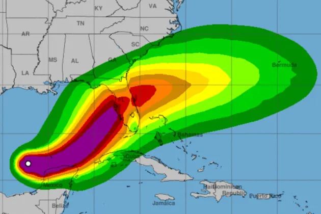
UPDATED, 1:20 a.m. PT: Hurricane Milton has officially became one of the strongest storms ever recorded in the Atlantic Basin. Milton’s maximum sustained winds reached 180 mph late Monday, then declined to 155 mph as the storm skimmed across the top of Cancun, Mexico. It is now a Category 4 cyclone and expected explode in size as it approaches Florida, making landfall as a Category 3 major hurricane.
More important than windspeed — and meteorologists say more accurate — is the storm’s barometric pressure. Pressure more accurately predicts damage from storm surge, inland flooding and tornadoes as well as storm size or storm duration over a community.
More from Deadline
Donald Trump’s Univision Town Hall Postponed As Hurricane Milton Intensifies And Threatens Florida
Dolly Parton Donates $1 Million To Hurricane Helene Relief, With Her Companies Matching The Amount
Hurricane Helene Hits Florida Theme Parks: Peppa Pig Park Closes, Disney World Opens
To that point, Milton’s pressure dropped to 897 millibars on Monday night. That’s the fifth-lowest reading ever seen in the Atlantic Basin. The other storms in that group are Rita in 2005 at 895 mb, the Labor Day Hurricane of 1935 at 892 mb, Gilbert in 1988 at 888 mb and Wilma in 2005 at 882 mb. Since dropping to 897, Milton’s pressure has since come up to 924 mb.
For a sense of the storm’s power as it brushed past Cancun, see the video below of conditions there on Monday night.
Cancun right now. I’ve never seen lightening like this😳#Milton #Cancun pic.twitter.com/WEf5TMFJdb
— SugaIsMyPetRock (Pamela) (@Pamella_Burks) October 8, 2024
Walt Disney World Resort on Monday announced the first closures as Milton barrels toward Florida. Some attractions are expected to be closed for days after the storm, according to a WDW statement.
Resort officials say they are “closely monitoring the path of the projected storm, and the safety of our Guests and Cast Members remains our top priority.” While Walt Disney World Resort announced on Monday that it “is currently operating under normal conditions and will continue to be on Tuesday,” officials have just announced the first “Looking ahead, we are making “adjustments based on the latest weather forecast and some areas with unique environments.”
Those are:
Disney’s Fort Wilderness Resort & Campground (including dining and recreation locations), the Copper Creek Cabins at Disney’s Wilderness Lodge, and the Treehouse Villas at Disney’s Saratoga Springs Resort & Spa will temporarily close beginning at 11:00 AM on Wednesday, Oct. 9.
Disney’s Fort Wilderness Resort & Campground and the Treehouse Villas at Disney’s Saratoga Springs Resort & Spa are likely to remain closed until Sunday, Oct. 13.
The Copper Creek Cabins at Disney’s Wilderness Lodge will likely reopen on Friday, Oct. 11.
The resort’s cancellation or change policy in regard to hurricanes reads as follows:
If a hurricane warning is issued by the National Hurricane Center for the Orlando area—or for your place of residence—within 7 days of your scheduled arrival date, you may reschedule or cancel your Walt Disney Travel Company Disney Resort hotel packages and most room only reservations (booked directly with Disney) without any cancellation or change fees imposed by Disney.
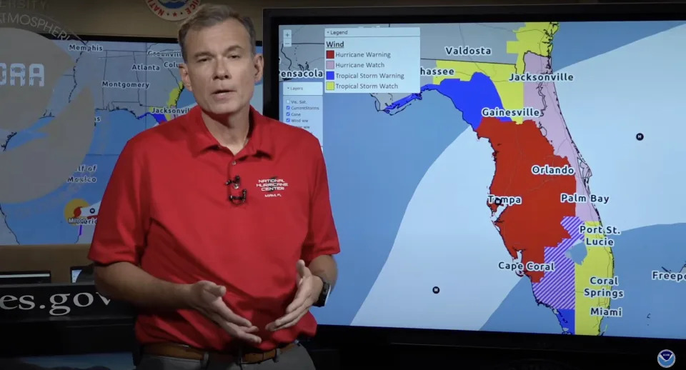
The NWS announced on Monday evening that Orlando (and much of the rest of west and central Florida) is currently under a Hurricane Warning, which means that hurricane conditions are expected.
In 2022, much of Walt Disney World closed for three days as Hurricane Ian brought gusts of 74 mph to Orlando International Airport and 14 inches of rain to the region. Universal Orlando also closed. Flooding was a major issue and, with airports closed, WDW had some guests shelter in place through the storm. Guests trapped inside its resort hotels had the makings of a horror movie. Instead, WDW castmembers’ above-and-beyond care for those guests was a bright spot in our related coverage.
How Milton impacts the parks remains to be seen. But Florida’s governor is not expecting sunshine.
“We have to assume this is going to be a monster,” said Florida Governor Ron DeSantis at a Monday briefing on Hurricane Milton preparations.
As the storm hit sustained winds of 180 mph on Monday, Milton’s sustained wind speed had jumped 100 mph in 24 hours as it went from tropical storm to Cat. 5 hurricane in near-record time. According to the National Hurricane Service, only Wilma in 2005 and Felix in 2007 intensified more quickly.
As a result, states of emergency have been declared in counties across the state as residents and visitors begin to evacuate. Sporting events are being postponed and some WDW-adjacent Florida theme parks are being closed. Donald Trump’s scheduled town hall with Univision was also postponed.
In Winter Haven Florida just north of Orlando, Peppa Pig Theme Park will shutter today through Thursday, October 10. Hotel operations will continue with limited capacity. The park also closed down during Helene. Nearby LEGOLAND Florida will be closed on Wednesday, October 9 through Thursday, October 10. Hotel operations there will also continue with limited capacity.
DeSantis, for his part, said the federal government has given him everything he has asked for, rebutting media questions seeking to identify any friction between the combative GOP governor and the Biden Administration. He also noted that emergency personnel were coming from as far away as rival Gavin Newsom’s California.
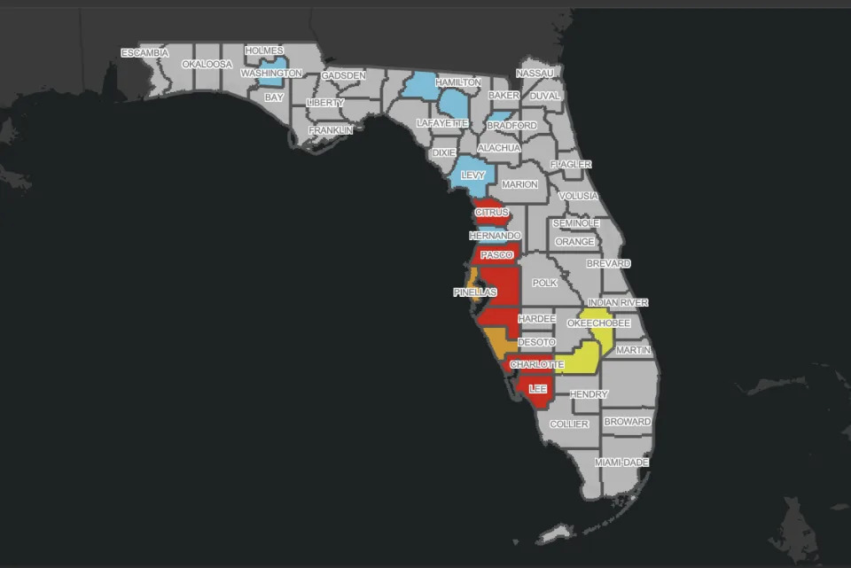
DeSantis said a state of emergency had been declared in 51 counties, including Hillsborough, Pinellas, Pasco, Miami-Dade, Broward, Orange and Osceola (the major Orlando resorts are located in the latter two counties).
Milton is expected to slam into Florida near Tampa at around 8 p.m. Wednesday.
The storm is expected to weaken further before it makes landfall, likely still as a Category 3 major hurricane. Even that would be a historic, unprecedented landfall for the vulnerable Tampa Bay region. Weather Channel meteorologists noted Monday afternoon that storms that start at Cat. 5 and weaken just before landfall are often very large and very destructive, even though they’ve lost wind velocity. That was the case with Hurricane Katrina.
Per the latest NWS forecast at 4 p.m. ET on Monday: “Radar data indicate that Milton could be at the beginning of an eyewall replacement cycle, with some signs of a moat and a partial outer eyewall. The evolution will likely cause the system to gradually weaken on Tuesday but grow larger.”
The top sustained winds ever for a cyclone in the region were recorded in 1980 with Hurricane Allen. Its winds were estimated to have reached 190 mph before it slackened and made landfall in Texas.
A Hurricane Watch is in effect for the Florida Gulf coast from Chokoloskee to the mouth of the Suwanee River, including Tampa Bay, Dry Tortugas and Lake Okeechobee near palm beach. Nearly the entire state of Florida — besides the Panhandle — is under a Flash Flood Watch. A Storm Surge Warning is in effect for the Florida Gulf coast from Flamingo northward to the mouth of the Suwannee River, including Charlotte Harbor and Tampa Bay. Many of those areas are still piled with debris and wreckage from Helene.
This is Anna Maria Island, near Tampa, after Helene. A complete loss- looks like a bomb went off. The residents didn’t have time to clear this debris before having to evacuate again for Hurricane Milton, which will be a major hurricane when it hits on Wednesday. Heart breaking. pic.twitter.com/YbCJbYBXVc
— Ella Dorsey (@Ella__Dorsey) October 7, 2024
Smack in the middle of Milton’s current predicted path is Tampa Bay and its barrier islands.

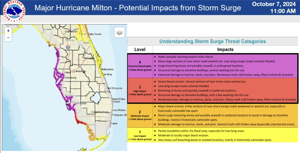
“The combination of a dangerous storm surge and the tide will cause normally dry areas near the coast to be flooded by rising waters moving inland from the shoreline,” a NWS statement read. “The water could reach the following heights above ground somewhere in the indicated areas if the peak surge occurs at the time of high tide…”
The NWS updated its surge forecast for the west coast of Florida this evening, moving Tampa Bay and environs from 8-12 feet to 10-15 feet.
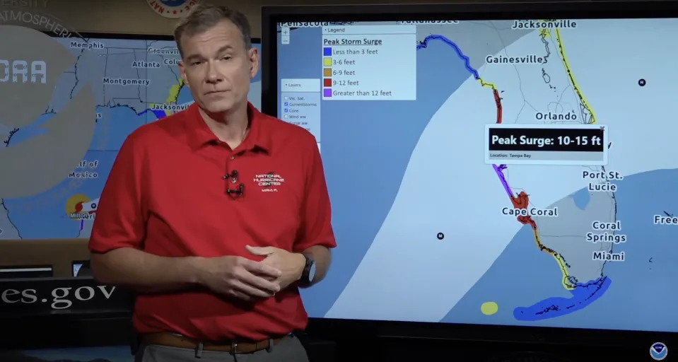
For comparison, Hurricane Helene brought a maximum storm surge of eight feet to the barrier islands around Tampa Bay. That was less that two weeks ago. Now, the region could see a column of water very close to double that stacked across some low-lying areas.
The deadliest hurricane in the Tampa region’s recorded history was a Cat. 3 storm that hit in October of 1921. It killed eight people. At the time, the population of the area was about 120,000, according to reporting by the New York Times. Its current population is three million.
In recent history, Tampa Bay has dodged major impacts. That will no longer be the case after Milton.
“We are telling people this will be like the worst hurricane in their lifetime in Tampa Bay,” Rick Davis, a meteorologist at the National Weather Service in Tampa, told the paper.
Tampa International Airport will close at 9 a.m. today and St. Pete-Clearwater Airport will close after the last flight today and remain closed Wednesday and Thursday, according to the Orlando Sentinel.
In Orlando, which is inland but also directly in the predicted path of the storm, a local state of emergency has been declared in the city. Orlando International Airport and Orlando Executive Airport announced they will cease operations in advance of Hurricane Milton beginning Wednesday morning.
Even as Milton weakens it will scour the state. The inland region is likely to see hurricane-force winds.
“Milton is forecast to remain a hurricane as it crosses the Florida Peninsula and life-threatening hurricane-force winds, especially in gusts, are expected to spread inland across a portion of the entire Florida Peninsula,” according to the 4 p.m. ET NWS forecast on Monday.
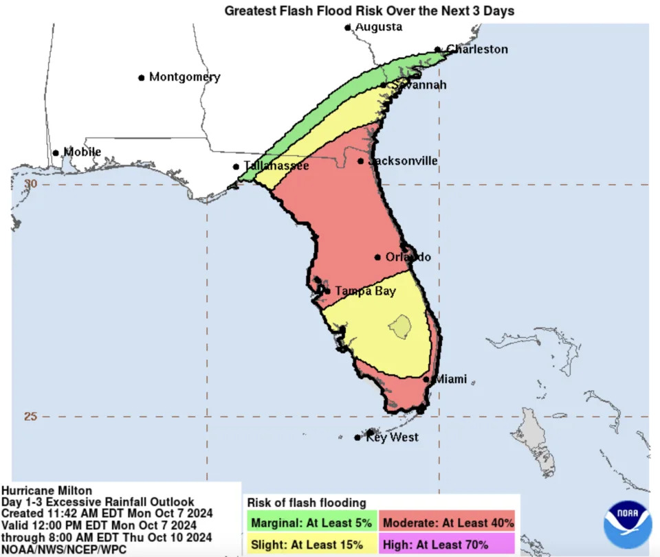
While NWS graphics released Sunday put Orlando on the edge of the swath at moderate risk of flash flooding (see below for that archived graphic), Monday’s update (see above) puts the city and most of Northern Florida in that category.
The Weather Channel today reported traffic on the I-4 at a standstill heading north as residents and visitors begin evacuating. Video posted online showed the backup.
#HurricaneMilton Evacuation traffic in Orlando on I-4 East is backed up all the way from downtown past Highway 17 in Lake Alfred #FLwx pic.twitter.com/XTN4elelKP
— Chris FL Tornado (@ChrisFLTornado) October 7, 2024
The current color-coded map of evacuation orders issued by Florida Governor Ron DeSantis is below.
Further south near Fort Lauderdale, the NHL champion Florida Panthers postponed their ring ceremony which had been set for today out of an abundance of caution.
UPDATED, 6:43 AM: Hurricane Milton has intensified into a Category 4 hurricane, with a dangerous surge threatening Tampa Bay.
In a briefing this morning, the National Weather Service said that Milton will be a historic storm for the west coast of Florida and that its path includes Tampa and Orlando.
PREVIOUSLY, October 6: Ten days after the Southeast was wracked by Helene, one the deadliest storms in modern history, the National Weather Service today forecast that newly formed Hurricane Milton is headed toward Central Florida and could impact the entire state.
“Milton is forecast to move just north of the Yucatan Peninsula and across the southern Gulf of Mexico on Monday and Tuesday and approach the west coast of the Florida Peninsula by Wednesday,” reads a NWS report.
“Maximum sustained winds have increased to near 90 mph (150 km/h) with higher gusts. Milton is forecast to intensify rapidly and become a major hurricane on Monday.”
That means Milton will shift from a tropical storm to a Cat. 3 hurricane in the space of 24 hours. Cat. 3 on the Saffir-Simpson Scale means winds of 111-129 mph. Per the NWS, “The official intensity forecast…shows Milton rapidly strengthening to category 4 intensity within the next couple of days.” Thankfully, it is expected to weaken slightly before reaching the west coast of Florida. According to the chart below, it is expected to make landfall as a major hurricane, likely Cat. 3.
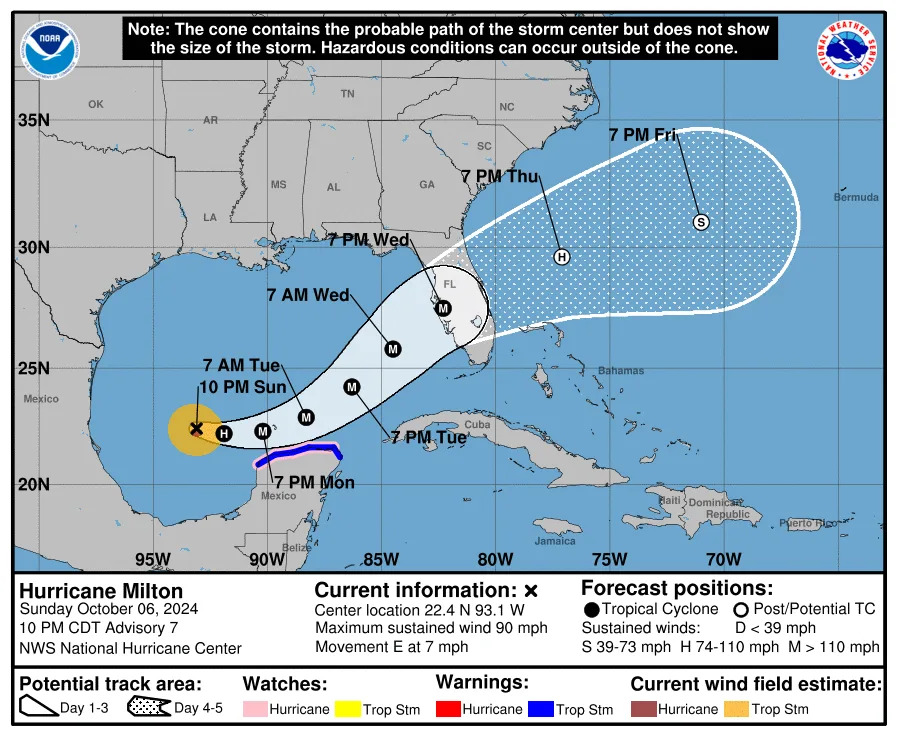
Hurricane-force winds currently extend outward up to 25 miles from the center and tropical-storm-force winds up to 80 miles out.
Florida Gov. Ron DeSantis said Sunday that most of the state will likely be impacted. He has declared a state of emergency in 51 counties, including Hillsborough, Pinellas, Pasco, Miami-Dade and Broward.
“I don’t think there’s any scenario where we don’t have significant impacts at this point,” he said at a news conference. “If you’re on that west coast of Florida and barrier islands, just assume that you likely are going to be called upon to evacuate.”
Unnamed hurricanes of 1909, 1910, 1929, 1933, 1945, and 1949 were all Category 3 storms when they struck South Florida, as were King of 1950, Betsy of 1965, Jeanne of 2004, and Irma of 2017. Milton would be the third hurricane to hit the state this year.
The current forecast cone, which could change drastically in the next two days, has Milton making landfall just south of Tampa Bay which just 10 days ago saw a storm surge of eight feet on some of the barrier islands in and around Pinellas County. Local officials there are desperately trying to clean up debris from Helene so they don’t become airborne or floodborne projectiles.
Officials told the Tampa Bay Times that Milton could be far worse than Helene. Sewage systems and power could be out for weeks, according to the paper’s reporting.
DeSantis warned in a statement posted to social media that the storm threatens more than just the state’s west coast.
“Impacts will be felt across the Florida peninsula, as Milton is forecasted to exit Florida’s east coast as a hurricane,” wrote the governor.
In a news conference with the governor, Florida Division of Emergency Management Director Kevin Guthrie told residents, “I highly encourage you to evacuate. We are preparing, and I have the State Emergency Response Team preparing, for the largest evacuation that we have seen most likely since 2017 Hurricane Irma.”
'I highly encourage you to evacuate': State officials say they are planning for what may be the largest evacuation Florida has seen since Hurricane Irma in 2017. MORE: https://t.co/BNR4Pido38 pic.twitter.com/5JALWaRK9t
— FOX Weather (@foxweather) October 6, 2024
The storm’s current projected path takes it over Orlando, with the region and its theme parks just on the edge of the greatest projected risk of flash flooding over the next five days, at 40%. During Helene, Walt Disney World and Universal Orlando mostly stayed open, closing only a few outdoor attractions.
Peppa Pig Theme Park Florida closed its doors on September 27, after the storm damaged attractions at the preschool experience. SeaWorld Orlando shut at 2 p.m on the 26th. Busch Gardens Tampa, Adventure Island, and Aquatica Orlando also shut down that day.
Orange and Osceola Counties, in which the parks sit, are among those DeSantis placed under a state of emergency this weekend in anticipation of the storm. Currently, both of the Orlando parks have issued notices that they are currently operating as normal but “closely monitoring” the storm as it develops.
Of note, the low-lying area in and around Miami is also projected to be at the greatest flash flood risk.

Per the NWS, “After crossing Florida, the cyclone should turn east-northeastward to eastward over the Atlantic waters off the southeastern United States.” Currently, it looks set to spare hard-hit western North Carolina.
Greg Evans contributed to this story
No comments:
Post a Comment