Tuesday, March 31, 2020

The placebo effect and psychedelic drugs: tripping on nothing?

by McGill University

Credit: CC0 Public Domain

There has been a lot of recent interest in the use of psychedelic drugs to treat depression. A new study from McGill suggests that, in the right context, some people may experience psychedelic-like effects from placebos alone. The researchers reported some of the strongest placebo effects (these are effects from "fake" medication) on consciousness in the literature relating to psychedelic drugs. Indeed, 61% of the participants in the experiment reported some effect after consuming the placebo.

"The study reinforces the power of context in psychedelic settings. With the recent re-emergence of psychedelic therapy for disorders such as depression and anxiety, clinicians may be able to leverage these contextual factors to obtain similar therapeutic experiences from lower doses, which would further improve the safety of the drugs," said Jay Olson, a Ph.D. candidate in McGill's Department of Psychiatry and the lead author on the research paper that was recently published in Psychopharmacology.

Setting the mood

Participants, who were expecting to take part in a study of the effects of drugs on creativity, spent four hours together in a room that had been set up to resemble a psychedelic party, with paintings, coloured lights and a DJ. To make the context seem credible and hide the deception, the study also involved ten research assistants in white lab coats, psychiatrists, and a security guard.

The 33 participants had been told they were being given a drug which resembled the active ingredient in psychedelic mushrooms and that they would experience changes in consciousness over the 4-hour period. In reality, everyone consumed a placebo. Among the participants were several actors who had been trained to slowly act out the effects of the ostensible drug. The researchers thought that this would help convince the participants that everyone had consumed a psychedelic drug and might lead them to experience placebo effects.

Strong effects for a placebo

When asked near the end of the study, the majority (61%) of the participants reported some effect of the drug, ranging from mild changes to effects resembling taking a moderate or high dose of an actual drug, though there was considerable individual variation. For example, several participants stated that they saw the paintings on the walls "move" or "reshape" themselves. Others described themselves as feeling "heavy... as if gravity [had] a stronger hold", and one had a "come down" before another "wave" hit her. Several participants reported being certain that they had taken a psychedelic drug.

"These results may help explain 'contact highs' in which people experience the effects of a drug simply by being around others who have consumed it," says Samuel Veissière, a cognitive anthropologist who teaches in McGill's Department of Psychiatry and supervised the study. "More generally, our study helps shed light on the 'placebo boosting' component inherent in all medical and therapeutic intervention, and the social influences that modulate these enhancing effects. Placebo effects may have been under-estimated in psychedelic studies. The current trend towards 'micro-dosing' (consuming tiny amounts of psychedelic drugs to improve creativity), for example, may have a strong placebo component due to widespread cultural expectations that frame the response."


Explore furtherNew research confirms lingering mood benefit of psychedelics

More information: Jay A. Olson et al, Tripping on nothing: placebo psychedelics and contextual factors, Psychopharmacology (2020). DOI: 10.1007/s00213-020-05464-5
Provided by McGill University


TUNE IN, TURN ON, DROP OUT

IS A MATTER OF MIND

YOU CAN BE ANYBODY THIS 

THE CORRECT AND INCORRECT WAY TO SOCIAL DISTANCE  


CORRECT

Striking Health Care Workers in New York City outside hospital practicing proper Social Distancing during protest picket over lack of proper PPE for staff.


INCORRECT
MARCH 27/2020 TRUMP SIGNING $2 TRILLION DOLLAR RELIEF BILL


PRAYING FOR TRUMP MARCH 2020


THE RESULT OF FAILING TO SOCIAL DISTANCE DURING PANDEMIC


The architecture of a 'shape-shifting' norovirus
THAT OTHER VIRUS THAT CONTAMINATES CRUISE SHIPS
by University of Leeds
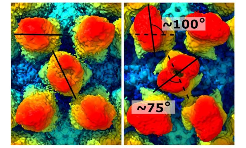
The murine norovirus captured by cryo-electron microscopy. Credit: University of Leeds

Every picture tells a story... none more so than this detailed visualisation of a strain of the norovirus.

Created from 13,000 separate images taken by an electron microscope, it reveals in rich detail the structure of the virus. It shows bump-like protrusions on the outside of the virus capsid, the protein shell that holds the genome of the virus.

Joseph Snowden, a Ph.D. researcher from the Astbury Centre for Structural Molecular Biology at the University of Leeds, said it revealed that the protein casing did not keep a fixed shape—as the protrusions on the surface would extend, retract and rotate.

This dynamic shape-shifting may hold clues as to why the noroviruses are such potent pathogens, responsible for over 200,000 deaths worldwide each year, mainly in low-to-middle-income countries. In the UK, noroviruses cause the winter vomiting bug that forces the closure of schools and hospitals.

To identify subtle changes to the structure of these protein shells, the scientists processed the data from the images with a super computer, using a method called "focussed classification".

The study, Dynamics in the murine norovirus capsid revealed by high-resolution cryo-EM, is reported in the online journal PLOS Biology.

For safety reasons, the researchers used a mouse norovirus in their study, which closely resembles the human noroviruses.
How the protrusions on the exterior of the virus change shape. Credit: University of Leeds

Mr Snowden said: "The constant changing or morphing of the virus shell may enable it to confuse the body's defence systems.

"Immune systems work on the basis of molecular shape. The body's defences will produce proteins that bind to pathogens to prevent them from infecting host cells. But if the shape of the virus is constantly changing, the body's defence systems may be unable to act efficiently."

The protrusions seem able to move independently or in a co-ordinated fashion and the scientists believe this may enable the virus to prime itself ready for infection depending on where it is—i.e. if it is in the digestive tract of a host organism.

It is believed that this study is the first study to use the focussed classification computing tool to investigate the structure of a norovirus.

Structural insight to aid vaccine development

Dr. Morgan Herod, one of the senior authors on this study, also from the University of Leeds, hopes that a greater understanding of the structure of the norovirus may help with vaccine development, which so far has been unsuccessful.

Dr. Herod said "The University of Leeds has a strong track record in the use of virus like particles (VLPs) to create vaccine candidates, for example against polio. VLPs are harmless proteins modelled on the structure of a virus's casing and they fool the immune system into thinking the body is under attack, prompting an immune response. "

"Our research shows that the capsid or protein shell of norovirus is dynamic—and perhaps we have to look at VLPs that are better able to mimic this aspect of norovirus structure."

"That will make the vaccine development task a little harder."


Explore furtherNorovirus structures could help develop treatments for food poisoning

More information: Dynamics in the murine norovirus capsid revealed by high-resolution cryo-EM, PLOS Biology (2020). journals.plos.org/plosbiology/ … al.pbio.pbio.3000649

Journal information: PLoS Biology
Sunny prospects for start-up's clear solar energy windows

by Peter Grad , Tech Xplore
Credit: Ubiquitous Energy

A Redwood City, California-based tech startup has developed a glass window packed with transparent photovoltaic cells that it believes will revolutionize the way solar energy is harnessed.

As companies around the world are increasingly working to expand and improve upon renewable energy resources, solar-energy based companies have been working to extract more energy from ever-smaller solar cells. Some resistance to the technology stemmed from the unsightly physical appearance of giant solar units placed on rooftops or vacant fields.

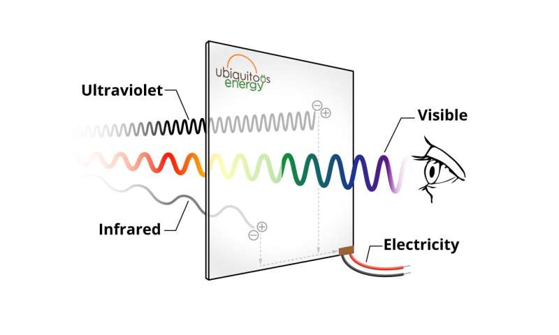
But Ubiquitous Energy Inc. has taken a different approach. Instead of joining competitors in trying to reduce the size of each solar cell, the company instead designed a solar panel of virtually clear glass that allows light to pass through unobstructed while tapping into the invisible ranges of the light spectrum.

Their product consists of an invisible layer of film about one one-thousandth of a millimeter thick that is layered onto existing glass components. It is clear and does not contain the blue-gray tint normally associated with solar panels.

The film, using what the company terms ClearView Power, allows the visible spectrum of light to pass through while absorbing near-infrared and ultraviolet light waves. Those waves are converted into energy. More than half of the light spectrum that can be used for energy conversion lies within those two ranges.

The panels will produce approximately two-thirds the power generated by traditional solar panels. And although installation of ClearView Power windows costs about 20 percent more than traditional windows, they are less expensive than rooftop-installed or remote solar power structures.

Miles Barr, the company's founder and chief technology officer, says he sees applications beyond merely windows in homes and office buildings.

"It can be applied to windows of skyscrapers; it can be applied to glass in automobiles; it can be applied to the glass on your iPhone," Barr said. "We really see the future of this technology as being applied everywhere, all around us, ubiquitous."

The solar units can be utilized in other everyday applications as well. Highway signage, for example, can be self-powered with these solar cells, as could supermarket shelf signage displaying product prices that can be updated at a moment's notice.

California has been a leader in the transition to renewable energy resources. State initiatives called for 33 percent of the state's electricity to come from alternate power sources by 2020, and half of all electric needs to be met by alternate sources by 2030.

California also this year began requiring all new homes to include some form of solar energy technology.

Explore furtherNew record could usher in new era for solar energy
AMERICA
Flooding stunted 2019 cropland growing season, resulting in more atmospheric CO2


by Robert Perkins, California Institute of Technology
Researchers are using satellite and aircraft observations to monitor regional land carbon fluxes in near real-time, as illustrated in this artist's concept. Satellite observations of solar-induced chlorophyll fluorescence (SIF) were used to track photosynthesis and estimate corresponding changes in land surface carbon fluxes. Meanwhile, atmospheric CO2 concentrations, which are influenced by the land surface carbon fluxes, can be observed by aircraft and from space. In this illustration, the two satellites depicted from left to right are: TROPOMI (TROPOspheric Monitoring Instrument) and OCO-2 (Orbiting Carbon Observatory-2). The aircraft is the ACT-America (Atmospheric Carbon and Transport - America). Credit: NASA/JPL-Caltech

Severe flooding throughout the Midwest—which triggered a delayed growing season for crops in the region—led to a reduction of 100 million metric tons of net carbon uptake during June and July of 2019, according to a new study.
For reference, the massive California wildfires of 2018 released an estimated 12.4 million metric tons of carbon into the atmosphere. And although part of this deficit due to floods was compensated for later in the growing season, the combined effects are likely to have resulted in a 15 percent reduction in crop productivity relative to 2018, the study authors say.

The study, published March 31, 2020, in the journal AGU Advances, describes how the carbon uptake was measured using satellite data. Researchers used a novel marker of photosynthesis known as solar-induced fluorescence to quantify the reduced carbon uptake due to the delay in the crops' growth. Independent observations of atmospheric CO2 levels were then employed to confirm the reduction in carbon uptake.

"We were able to show that it's possible to monitor the impacts of floods on crop growth on a daily basis in near real time from space, which is critical to future ecological forecasting and mitigation," says Yi Yin, research scientist at Caltech and lead author of the study.

Record rainfalls soaked the Midwest during the spring and early summer of 2019. For three consecutive months (April, May, and June), the National Oceanic and Atmospheric Administration reported that 12-month precipitation measurements had hit all-time highs. The resulting floods not only damaged homes and infrastructure but also impacted agricultural productivity, delaying the planting of crops in large parts of the Corn Belt, which stretches from Kansas and Nebraska in the west to Ohio in the east.
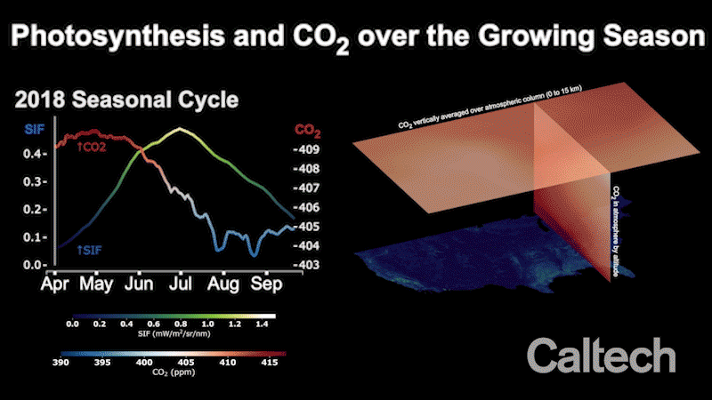
Credit: California Institute of Technology

To assess the environmental impact of the delayed growing season, scientists at Caltech and JPL, which Caltech manages for NASA, turned to satellite data. As plants convert carbon dioxide (CO2) and sunlight into oxygen and energy through photosynthesis, a small amount of the sunlight they absorb is emitted back in the form of a very faint glow. The glow, known as solar-induced fluorescence, or SIF, is far too dim for us to see with bare eyes, but it can be measured through a process called satellite spectrophotometry.

The Caltech-JPL team quantified SIF using measurements from a European Space Agency (ESA) satellite-borne instrument to track the growth of crops with unprecedented detail. They found that the seasonal cycle of the 2019 crop growth was delayed by around two weeks and the maximum seasonal photosynthesis was reduced by about 15 percent. The stunted growing season was estimated to have led to a reduction in carbon uptake by plants of around 100 million metric tons from June to July 2019.

"SIF is the most accurate signal of photosynthesis by far that can be observed from space," says Christian Frankenberg, professor of environmental science and engineering at Caltech. "And since plants absorb carbon dioxide during photosynthesis, we wanted to see if SIF could track the reductions in crop carbon uptake during the 2019 floods."

To find out, the team analyzed atmospheric CO2 measurements from NASA's Orbiting Carbon Observatory-2 (OCO-2) satellite as well as from aircraft from NASA's Atmospheric Carbon and Transport America (ACT-America) project. "We found that the SIF-based estimates of reduced uptake are consistent with elevated atmospheric CO2 when the two quantities are connected by atmospheric transport models," says Brendan Bryne, co-corresponding author of the study and a NASA postdoc fellow at JPL.

"This study illuminates our ability to monitor the ecosystem and its impact on atmospheric CO2 in near real time from space. These new tools allow for global sensing of biospheric uptake of carbon dioxide," says Paul Wennberg, the R. Stanton Avery Professor of Atmospheric Chemistry and Environmental Science and Engineering, director of the Ronald and Maxine Linde Center for Global Environmental Science, and founding member of the Orbiting Carbon Observatory project.

The paper is titled "Cropland carbon uptake delayed and reduced by 2019 Midwest floods."

Explore furtherStudy reveals dry season increase in photosynthesis in Amazon rain forest
More information: Yi Yin et al. Cropland Carbon Uptake Delayed and Reduced by 2019 Midwest Floods, AGU Advances (2020). DOI: 10.1029/2019AV000140
Study shows potential for using fiber-optic networks to assess ground motions during earthquakes

by Jim Erickson, University of Michigan
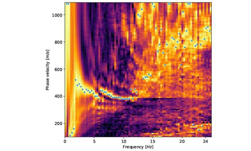
Analysis of seismic wave velocities using distributed acoustic sensing technique with fiber-optic cables. Credit: Zack Spica

A new study from a University of Michigan researcher and colleagues at three institutions demonstrates the potential for using existing networks of buried optical fibers as an inexpensive observatory for monitoring and studying earthquakes.
The study provides new evidence that the same optical fibers that deliver high-speed internet and HD video to our homes could one day double as seismic sensors.

"Fiber-optic cables are the backbone of modern telecommunications, and we have demonstrated that we can turn existing networks into extensive seismic arrays to assess ground motions during earthquakes," said U-M seismologist Zack Spica, first author of a paper published online Feb. 12 in the journal JGR Solid Earth.

The study was conducted using a prototype array at Stanford University, where Spica was a postdoctoral fellow for several years before recently joining the U-M faculty as an assistant professor in the Department of Earth and Environmental Sciences. Co-authors include researchers at Stanford and from Mexico and Virginia.

"This is the first time that fiber-optic seismology has been used to derive a standard measure of subsurface properties that is used by earthquake engineers to anticipate the severity of shaking," said geophysicist Greg Beroza, a co-author on the paper and the Wayne Loel Professor in Stanford's School of Earth, Energy & Environmental Sciences.

To transform a fiber-optic cable into a seismic sensor, the researchers connect an instrument called a laser interrogator to one end of the cable. It shoots pulses of laser light down the fiber. The light bounces back when it encounters impurities along the fiber, creating a "backscatter signal" that is analyzed by a device called an interferometer.

Changes in the backscatter signal can reveal how the fiber stretches or compresses in response to passing disturbances, including seismic waves from earthquakes. The technique is called distributed acoustic sensing, or DAS, and has been used for years to monitor the health of pipelines and wells in the oil and gas industry.

The new study in JGR Solid Earth extends previous work with the 3-mile Stanford test loop by producing high-resolution maps of the shallow subsurface, which scientists can use to see which areas will undergo the strongest shaking in future earthquakes, Beroza said.


In addition, the study demonstrates that optical fibers can be used to sense seismic waves and obtain velocity models and resonance frequencies of the ground—two parameters that are essential for ground-motion prediction and seismic-hazard assessment. Spica and his colleagues say their results are in good agreement with an independent survey that used traditional techniques, thereby validating the methodology of fiber-optic seismology.

This approach appears to have great potential for use in large, earthquake-threatened cities such as San Francisco, Los Angeles, Tokyo and Mexico City, where thousands of miles of optical cables are buried beneath the surface.

"What's great about using fiber for this is that cities already have it as part of their infrastructure, so all we have to do is tap into it," Beroza said.

Many of these urban centers are built atop soft sediments that amplify and extend earthquake shaking. The near-surface geology can vary considerably from neighborhood to neighborhood, highlighting the need for detailed, site-specific information.

Yet getting that kind of information can be a challenge with traditional techniques, which involve the deployment of large seismometer arrays—thousands of such instruments in the Los Angeles area, for example.

"In urban areas, it is very difficult to find a place to install seismic stations because asphalt is everywhere," Spica said. "In addition, many of these lands are private and not accessible, and you cannot always leave a seismic station standing alone because of the risk of theft.

"Fiber optics could someday mark the end of such large scale and expensive experiments. The cables are buried under the asphalt and crisscross the entire city, with none of the disadvantages of surface seismic stations."

The technique would likely be fairly inexpensive, as well, Spica said. Typically, commercial fiber-optic cables contain unused fibers that can be leased for other purposes, including seismology.

For the moment, traditional seismometers provide better performance than prototype systems that use fiber-optic sensing. Also, seismometers sense ground movements in three directions, while optical fibers only sense along the direction of the fiber.

The 3-mile Stanford fiber-optic array and data acquisition were made possible by a collective effort from Stanford IT services, Stanford Geophysics, and OptaSense Ltd. Financial support was provided by the Stanford Exploration Project, the U.S. Department of Energy and the Schlumberger Fellowship.

The next phase of the project involves a much larger test array. A 27-mile loop was formed recently by linking optical fibers on Stanford's historic campus with fibers at several other nearby locations.

The other authors of the JGR Solid Earth paper are Biondo Biondi of Stanford, Mathieu Perton of Universidad Nacional Autónoma de México and Eileen Martin of Virginia Tech.


Explore furtherResearchers build a 'billion sensors' earthquake observatory with optical fibers

More information: Zack J. Spica et al, Urban Seismic Site Characterization by Fiber‐Optic Seismology, Journal of Geophysical Research: Solid Earth (2020). DOI: 10.1029/2019JB018656

Sediments may control location, magnitude of megaquakes
by Geological Society of America
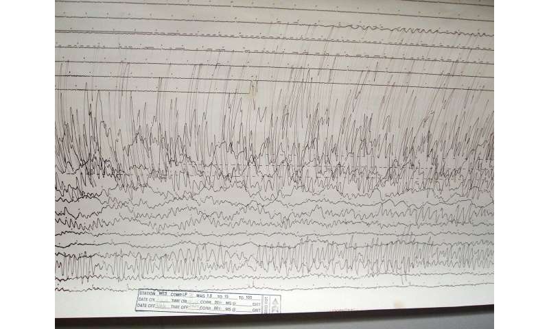
A seismogram of 2011 Tōhoku earthquake and tsunami
 recorded at Weston Observatory in Massachusetts, USA.
 Credit: Image from Wikimedia Commons.

The world's most powerful earthquakes strike at subduction zones, areas where enormous amounts of stress build up as one tectonic plate dives beneath another. When suddenly released, this stress can cause devastating "megaquakes" like the 2011 Mw 9.0 Tohoku event, which killed nearly 16,000 people and crippled Japan's Fukushima Dai-ichi Nuclear Power Plant. Now a study published in Geology suggests that sediments atop the downgoing slab can play a key role in determining the magnitude and location of these catastrophic events.

In this newly published study, a team led by Gou Fujie, a senior scientist at the Japan Agency for Marine-Earth Science and Technology, used a trio of geophysical methods to image the subducting sediments in the northeastern Japan arc, where the Tohoku event occurred. The findings suggest that variations caused by volcanic rocks intruded into these sediments can substantially influence the nature of subduction zone earthquakes.

"Our imaging shows that the enormous amount of slip that occurred during the 2011 Tohoku earthquake stopped in an area of thin sediments that are just starting to subduct," says Fujie. "These results indicate that by disturbing local sediment layers, volcanic activity that occurred prior to subduction can affect the size and the distribution of interplate earthquakes after the layers have been subducted."

Researchers first began to suspect that variations in subducting sediments could influence megaquakes after the 2011 Tohoku event, when international drilling in the northeastern Japan arc showed that giant amounts of slip during the earthquake occurred in a slippery, clay-rich layer located within the subducting sediments. To better understand the nature of the downgoing slab in this region, Fujie's team combined several imaging techniques to paint a clearer picture of the subseafloor structure.

The researchers discovered there are what Fujie calls "remarkable regional variations" in the sediments atop the downgoing plate, even where the seafloor topography seems to be flat. There are places, he says, where the sediment layer appears to be extremely thin due to the presence of an ancient lava flow or other volcanic rocks. These volcanic intrusions have heavily disturbed, and in places thermally metamorphosed, the clay layer in which much of the seismic slip occurred.

Because the type of volcanism that caused sediment thinning in the northeastern Japan arc has also been found in many areas, says Fujie, the research suggests such thinning is ubiquitous—and that this type of volcanic activity has also affected other seismic events. "Regional variations in sediments atop descending oceanic plates appear to strongly influence devastating subduction zone earthquakes," he concludes.

Explore further Upper and lower plate controls on the 2011 Tohoku-oki earthquake

More information: Gou Fujie et al. Spatial variations of incoming sediments at the northeastern Japan arc and their implications for megathrust earthquakes, Geology (2020). DOI: 10.1130/G46757.1

Journal information: Geology

Provided by Geological Society of America
Cat infected with COVID-19 from owner in Belgium
This is the first case of human-to-cat transmission of the novel coronavirus.

IT'S STILL ZOONOSIS

A cat in Belgium (not shown here) has been infected with the novel coronavirus.
(Image: © Shutterstock)

By  3/29/2020

A domestic cat in Belgium has been infected with COVID-19, the disease caused by the new coronavirus that's spreading across the globe, the government's FPS Public Health, Food Chain Safety and Environment announced March 27, according to news reports.

This is the first human-to-cat transmission of the novel coronavirus (SARS-CoV-2). About a week after its owner got sick with COVID-19, after returning from a trip to Northern Italy, the cat developed coronavirus symptoms: diarrhea, vomiting and respiratory issues, Steven Van Gucht, virologist and federal spokesperson for the coronavirus epidemic in Belgium, told Live Science.

The owner sent samples of vomit and feces to Dr. Daniel Desmecht's lab at the Faculty of Veterinary Medicine of Liège. Genetic tests showed high levels of SARS-CoV-2 in those samples, he said. "The cat recovered after 9 days," Van Gucht said.

Related: 13 Coronavirus myths busted by science

Cats and humans appear to have a similar "doorknob" on the surfaces of respiratory cells that lets the SARS-CoV-2 virus get inside, according to Van Gucht.

In humans, scientists have figured out that the SARS-CoV-2 virus attaches to a receptor protein called ACE2 that's on the outside of respiratory cells. Once inside of these cells, the virus hijacks certain machinery so it can replicate.

"The feline ACE2 protein resembles the human ACE2 homologue, which is most likely the cellular receptor which is being used by Sars-CoV-2 for cell entry," Van Gucht said.

During the 2003 SARS outbreak, cats were infected with a coronavirus as well, Van Gucht said.

The only other pets thought to have "caught" the novel coronavirus from owners were two dogs in Hong Kong. The first dog, a 17-year-old Pomeranian, tested a weak positive for the virus at the end of February, Live Science reported. The dog died in mid-March, though the exact cause of death is not known, as the owner didn't allow an autopsy. A second dog, a German shepherd, tested positive but showed no symptoms of the disease, Bloomberg reported.

During the outbreak of another coronavirus, severe acute respiratory syndrome (SARS), dogs and cats contracted low levels of that virus, animal health expert Vanessa Barrs from City University told the South China Morning Post.

There have been no reports of pets passing the virus to their human owners, and Van Gucht stressed that even human-to-pet transmission is not a significant path of viral spread.

"We think the cat is a side victim of the ongoing epidemic in humans and does not play a significant role in the propagation of the virus," he said.

To prove definitively that the cat was infected with SARS-CoV-2, scientists will need a blood test to look for antibodies specific to this virus, Van Gucht said. Those tests will happen once the cat is no longer under quarantine.


Antarctica's Denman Glacier is sinking into the world's deepest canyon

The melting glacier could raise sea level by almost 5 feet (1.5 meters).

Denman trough (dark blue strip) sinks some 

11,000 feet (3,500 meters) below sea level, 
and could soon become the burial plot of a
 massive, dying glacier.
(Image: © NASA’s Scientific Visualization Studio)


By Brandon Specktor - Senior Writer 3/31/2020

The glaciers of Antarctica are melting at unprecedented rates, and a giant canyon in the continent's rocky underbelly could make matters much worse.

In a study published March 23 in the journal Geophysical Research Letters, researchers used more than 20 years of satellite data to monitor the ice in Denman Glacier — a 12-mile wide (20 kilometers) stream of ice in East Antarctica — along with the bedrock beneath it. The researchers found that, not only did Denman's western flank retreat nearly 3 miles (5 km) between 1996 and 2018, but that a deep canyon below the glacier may be causing the glacier to melt faster than it can possibly recover.

Denman Glacier's western flank flows over the deepest known land canyon on Earth, plunging at least 11,000 feet (3,500 meters) below sea level. Right now, that canyon (known as the Denman trough) is mostly cut off from the sea thanks to all the glacial ice piled inside and atop the ravine. However, as the glacier's edge continues to retreat farther and farther down the slope, warm ocean water will pour into the canyon, battering bigger and bigger sections of the glacier and gradually turning the Denman trough into a giant bowl of meltwater with nowhere else to go.

This scenario, the researchers wrote, could kick off a runaway feedback loop of melt that ultimately returns all of Denman Glacier's ice to the sea — risking nearly 5 feet (1.5 m) of global sea level rise.

"Because of the shape of the ground beneath Denman's western side, there is potential for rapid and irreversible retreat, and that means substantial increases in global sea levels in the future," lead study author Virginia Brancato, a postdoctoral fellow with NASA's Jet Propulsion Laboratory, said in a statement.
Losing frozen ground


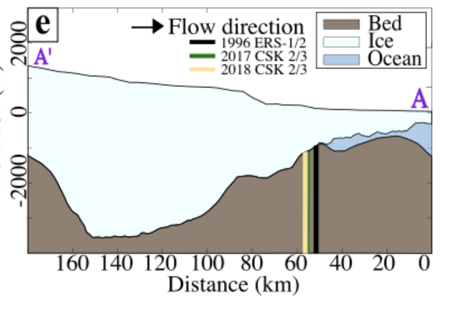
This map shows Denman Glacier's grounding line retreating between 1996 (the black line) and 2018 (yellow line). The large dip in the bedrock represents Denman trough, a canyon reaching a maximum depth of 11,000 feet (3,500 meters) below sea level. The glacier's grounding line has already begun creeping down the canyon's wall. (Image credit: AGU/ Brancato et. al)

Glaciers are giant slabs of ice sitting atop continental bedrock. Most glaciers in Antarctica, including Denman, end in large ice shelves or "tongues" that jut away from the land and into the open ocean, where their edges slowly snap into pieces and form new icebergs. The point where a glacier first leaves the bedrock and begins to float in the water is called the grounding line. The location of this line is key to a glacier's stability; when warm ocean water melts away exposed glacial ice, the grounding line retreats farther and farther back, making nearby ice sheets less stable and more prone to melting and cracking.

In the new study, researchers used satellite data from the German Aerospace Center and the Italian Space Agency to measure how far Denman Glacier's grounding line retreated in the 22 years between 1996 and 2018, and how much mass the glacier lost in melted ice. They saw extensive melting — Denman lost more than 268 billion tons (2.43 metric tons) of ice in those two decades — and an alarming rate of retreat on one side of the glacier only.

While there was little retreat on Denman's eastern flank (where a rocky ridge stabilizes the grounding line), the glacier's western flank shot back by nearly 3 miles (5 km), plunging partway down the slope of the massive Denman trough.

If current global warming trends continue, that trough could spell doom for Denman glacier, the researchers wrote. As the glacier's grounding line continues to sink farther down the canyon (which already sits below sea level), warm ocean water will batter larger and larger chunks of the glacier's edge, causing it to melt even faster and make the precarious ice shelf above even more vulnerable to collapse.

If that happens, it's likely that Denman Glacier will undergo a "rapid and irreversible retreat" with "major consequences" for sea level rise, the researchers wrote in the study. This possibility should be a wake-up call to scientists who previously considered melt in East Antarctica a relatively benign threat compared to the rapidly melting Pine Island and Thwaites glaciers in West Antarctica, the authors concluded.

"The ice in West Antarctica has been melting faster in recent years, but the sheer size of Denman Glacier means that its potential impact on long-term sea level rise is just as significant," study co-author Eric Rignot, a professor of Earth system science at the University of California, Irvine, said in the statement.
23 SKIDOO
Stolen painting reappears after 23 years, in the same gallery where it was taken
Why steal a painting and leave it behind


The missing Gustav Klimt painting 'Portrait of a Lady' is displayed after being stolen 23 years ago.
(Image: © Antonio Calanni/AP/Shutterstock)

A famous painting by Austrian Gustav Klimt had been missing for 23 years. Now, it turns out, the painting was hidden in the walls of the gallery from which it was stolen.

The 1917 Klimt, known as "Portrait of a Lady," was found missing from the Ricci Oddi modern art gallery in Piacenza, Italy, on Feb. 22, 1997. It's still unknown who took the artwork, but now it appears that the painting may have never left the gallery grounds. A gardener at the gallery said he was clearing ivy on Dec. 10, 2019, according to the Associated Press, when he found a bag in a gap in the walls. That bag contained the portrait, in remarkably undamaged condition.

"It's with no small emotion that I can tell you the work is authentic," Piacenza prosecutor Ornella Chicca said during a Jan. 14 press conference, according to the Associated Press.

Related: In Photos: Medieval art tells a tale

The only major sign of wear, according to the AP, is a small mark on the side of the painting where it may have been hurriedly removed from its frame.

Klimt, an Austrian painter best known for his colorful, patterned portraits of women, produced works that now command enormous sums on the open market. According to the AP, Oprah Winfrey recently sold Klimt's "Portrait of Adele Bloch-Bauer II" for $150 million.

It's possible, according to Anne-Marie O'Connor, an expert in stolen Klimt art who was interviewed by the AP, that the thieves stashed "Portrait of a Lady" in the gallery wall – hoping to return to recover and sell it once news of the theft died down. But in the 1990s, the values of Klimt's works were climbing sharply; the thieves may have concluded it would never be possible to sell the artwork to a private buyer.

O'Connor is the author of a book, "The Lady in Gold," which documents the successful effort to recover five other stolen Klimt works. The paintings desribed in the book — the most notable of which was "Portrait of Adele Bloch-Bauer I" — were stolen by Nazis during the Holocaust from the Jewish Block-Bauer family. The works ended up in the possession of the Austrian government. Adele Bloch-Bauer's niece Maria Altmann filed a lawsuit in 2000 demanding the paintings' return. The suit ended up in front of the U.S. Supreme Court, and the paintings were returned to Altmann in 2006.

The 23 Phenomenon By Robert Anton Wilson Fortean Times, Issue #23, 1977 I first heard of the 23 enigma from William S Burroughs, author of Naked Lunch, Nova Express, etc. According to Burroughs, h

---23---