Flooding stunted 2019 cropland growing season, resulting in more atmospheric CO2
by Robert Perkins, California Institute of Technology

Researchers are using satellite and aircraft observations to monitor regional land carbon fluxes in near real-time, as illustrated in this artist's concept. Satellite observations of solar-induced chlorophyll fluorescence (SIF) were used to track photosynthesis and estimate corresponding changes in land surface carbon fluxes. Meanwhile, atmospheric CO2 concentrations, which are influenced by the land surface carbon fluxes, can be observed by aircraft and from space. In this illustration, the two satellites depicted from left to right are: TROPOMI (TROPOspheric Monitoring Instrument) and OCO-2 (Orbiting Carbon Observatory-2). The aircraft is the ACT-America (Atmospheric Carbon and Transport - America). Credit: NASA/JPL-Caltech
Severe flooding throughout the Midwest—which triggered a delayed growing season for crops in the region—led to a reduction of 100 million metric tons of net carbon uptake during June and July of 2019, according to a new study.
Severe flooding throughout the Midwest—which triggered a delayed growing season for crops in the region—led to a reduction of 100 million metric tons of net carbon uptake during June and July of 2019, according to a new study.
For reference, the massive California wildfires of 2018 released an estimated 12.4 million metric tons of carbon into the atmosphere. And although part of this deficit due to floods was compensated for later in the growing season, the combined effects are likely to have resulted in a 15 percent reduction in crop productivity relative to 2018, the study authors say.
The study, published March 31, 2020, in the journal AGU Advances, describes how the carbon uptake was measured using satellite data. Researchers used a novel marker of photosynthesis known as solar-induced fluorescence to quantify the reduced carbon uptake due to the delay in the crops' growth. Independent observations of atmospheric CO2 levels were then employed to confirm the reduction in carbon uptake.
"We were able to show that it's possible to monitor the impacts of floods on crop growth on a daily basis in near real time from space, which is critical to future ecological forecasting and mitigation," says Yi Yin, research scientist at Caltech and lead author of the study.
Record rainfalls soaked the Midwest during the spring and early summer of 2019. For three consecutive months (April, May, and June), the National Oceanic and Atmospheric Administration reported that 12-month precipitation measurements had hit all-time highs. The resulting floods not only damaged homes and infrastructure but also impacted agricultural productivity, delaying the planting of crops in large parts of the Corn Belt, which stretches from Kansas and Nebraska in the west to Ohio in the east.
Credit: California Institute of Technology
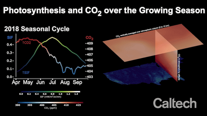
To assess the environmental impact of the delayed growing season, scientists at Caltech and JPL, which Caltech manages for NASA, turned to satellite data. As plants convert carbon dioxide (CO2) and sunlight into oxygen and energy through photosynthesis, a small amount of the sunlight they absorb is emitted back in the form of a very faint glow. The glow, known as solar-induced fluorescence, or SIF, is far too dim for us to see with bare eyes, but it can be measured through a process called satellite spectrophotometry.
The Caltech-JPL team quantified SIF using measurements from a European Space Agency (ESA) satellite-borne instrument to track the growth of crops with unprecedented detail. They found that the seasonal cycle of the 2019 crop growth was delayed by around two weeks and the maximum seasonal photosynthesis was reduced by about 15 percent. The stunted growing season was estimated to have led to a reduction in carbon uptake by plants of around 100 million metric tons from June to July 2019.
"SIF is the most accurate signal of photosynthesis by far that can be observed from space," says Christian Frankenberg, professor of environmental science and engineering at Caltech. "And since plants absorb carbon dioxide during photosynthesis, we wanted to see if SIF could track the reductions in crop carbon uptake during the 2019 floods."
To find out, the team analyzed atmospheric CO2 measurements from NASA's Orbiting Carbon Observatory-2 (OCO-2) satellite as well as from aircraft from NASA's Atmospheric Carbon and Transport America (ACT-America) project. "We found that the SIF-based estimates of reduced uptake are consistent with elevated atmospheric CO2 when the two quantities are connected by atmospheric transport models," says Brendan Bryne, co-corresponding author of the study and a NASA postdoc fellow at JPL.
"This study illuminates our ability to monitor the ecosystem and its impact on atmospheric CO2 in near real time from space. These new tools allow for global sensing of biospheric uptake of carbon dioxide," says Paul Wennberg, the R. Stanton Avery Professor of Atmospheric Chemistry and Environmental Science and Engineering, director of the Ronald and Maxine Linde Center for Global Environmental Science, and founding member of the Orbiting Carbon Observatory project.
The paper is titled "Cropland carbon uptake delayed and reduced by 2019 Midwest floods."
Explore furtherStudy reveals dry season increase in photosynthesis in Amazon rain forest
More information: Yi Yin et al. Cropland Carbon Uptake Delayed and Reduced by 2019 Midwest Floods, AGU Advances (2020). DOI: 10.1029/2019AV000140
Provided by California Institute of Technology
No comments:
Post a Comment