Saturday, August 19, 2023

A dramatic volcano eruption changed lives in Fiji 2,500 years ago—100 generations have kept the story alive

by Patrick D. Nunn, The Conversation
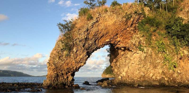
The hole made when a spear was thrown by one god at the other, on the north coast of eastern Kadavu. 
Credit: Patrick D. Nunn CC BY-ND.

Can you imagine a scientist who could neither read nor write, who spoke their wisdom in riddles, in tales of fantastic beings flying through the sky, fighting each another furiously and noisily, drinking the ocean dry, and throwing giant spears with force enough to leave massive holes in rocky headlands?

Our newly published research in the journal Oral Tradition shows memories of a volcanic eruption in Fiji some 2,500 years ago were encoded in oral traditions in precisely these ways.


They were never intended as fanciful stories, but rather as the pragmatic foundations of a system of local risk management.

Life-changing events


Around 2,500 years ago, at the western end of the island of Kadavu in the southern part of Fiji, the ground shook, the ocean became agitated, and clouds of billowing smoke and ash poured into the sky.

When the clouds cleared, the people saw a new mountain had formed, its shape resembling a mound of earth in which yams are grown. This gave the mountain its name—Nabukelevu, the giant yam mound. (It was renamed Mount Washington during Fiji's colonial history.)

So dramatic, so life-changing were the events associated with this eruption, the people who witnessed it told stories about it. These stories have endured more than two millennia, faithfully passed on across roughly 100 generations to reach us today.

Scientists used to dismiss such stories as fictions, devalue them with labels like "myth" or "legend". But the situation is changing.

Today, we are starting to recognize that many such "stories" are authentic memories of human pasts, encoded in oral traditions in ways that represent the worldviews of people from long ago.
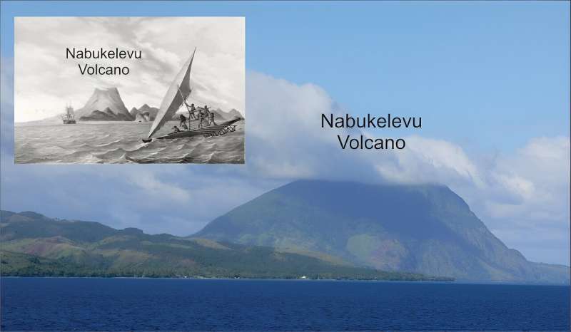
Nabukelevu from the northeast, its top hidden in cloud. Inset: Nabukelevu from the west in 1827 after the drawing by the artist aboard the Astrolabe, the ship of French explorer Dumont d’Urville. It is an original lithograph by H. van der Burch after original artwork by Louis Auguste de Sainson. Credit: Wikimedia Commons; Australian National Maritime Museum, CC BY-SA

In other words, these stories served the same purpose as scientific accounts, and the people who told them were trying to understand the natural world, much like scientists do today.

Battle of the vu


The most common story about the 2,500-year-old eruption of Nabukelevu is one involving a "god" (vu in Fijian) named Tanovo from the island of Ono, about 56km from the volcano.

Tanovo's view of the sunset became blocked one day by this huge mountain. Our research identifies this as a volcanic dome that was created during the eruption, raising the height of the mountain several hundred feet.

Enraged, Tanovo flew to Nabukelevu and started to tear down the mountain, a process described by local residents as driva qele (stealing earth). This explains why even today the summit of Nabukelevu has a crater.

But Tanovo was interrupted by the "god" of Nabukelevu, named Tautaumolau. The pair started fighting. A chase ensued through the sky and, as the two twisted and turned, the earth being carried by Tanovo started falling to the ground, where it is said to have "created" islands.

We conclude that the sequence in which these islands are said to have been created is likely to represent the movement of the ash plume from the eruption, as shown on the map below.

'Myths' based in fact


Geologists would today find it exceedingly difficult to deduce such details of an ancient eruption. But here, in the oral traditions of Kadavu people, this information is readily available.
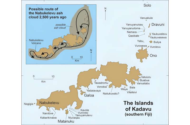

Smaller offshore islands named in seven versions of the Nabukelevu story as having formed following the Nabukelevu eruption. Inset shows the possible trace of the ash cloud based on the stories. Credit: Patrick D. Nunn, CC BY-ND.

Another detail we would never know if we did not have the oral traditions is about the tsunami the eruption caused.

In some versions of the story, one of the "gods" is so frightened, he hides beneath the sea. But his rival comes along and drinks up all the water at that place, a detail our research interprets as a memory of the ocean withdrawing prior to tsunami impact.

Other details in the oral traditions recall how one god threw a massive spear at his rival but missed, leaving behind a huge hole in a rock. This is a good example of how landforms likely predating the eruption can be retrofitted to a narrative.

Our study adds to the growing body of scientific research into "myths" and "legends", showing that many have a basis in fact, and the details they contain add depth and breadth to our understanding of human pasts.

The Kadavu volcano stories discussed here also show ancient societies were no less risk aware and risk averse than ours are today. The imperative was to survive, greatly aided by keeping alive memories of all the hazards that existed in a particular place.

Australian First Peoples' cultures are replete with similar stories.


Literate people, those who read and write, tend to be impressed by the extraordinary time depth of oral traditions, like those about the 2,500-year old eruption of Nabukelevu. But not everyone is.

In early 2019, I was sitting and chatting to Ratu Petero Uluinaceva in Waisomo Village, after he had finished relating the Ono people's story of the eruption. I told him this particular story recalled events which occurred more than two millennia ago—and thought he might be impressed. But he wasn't.

"We know our stories are that old, that they recall our ancient history," he told me with a grin. "But we are glad you have now learned this too!"


Provided by The Conversation

This article is republished from The Conversation under a Creative Commons license. Read the original article.


Explore furtherEvidence the oral stories of Australia's First Nations might be 10,000 years old


SEE


  • James Churchward - Wikipedia

    https://en.wikipedia.org/wiki/James_Churchward

    James Churchward (27 February 1851 – 4 January 1936) was a British occult writer, inventor, engineer, and fisherman. Churchward is most notable for proposing the existence of a lost continent, called "Mu," in the Pacific Ocean. His writings on Mu are considered to be pseudoscience.

    Churchward was born in Bridestow, Okehampton, Devon at Stone House to Henry and Matilda (née Gould) Churchward. James had four brothers and four sisters. In November 1854, Henry died and the family moved in with Matilda's parents in the hamlet of Kigbear, near Okehampton. Census records indicate the family next moved to London when James was 18 after his grandfather George Gould died. 

    Wikipedia · Text under CC-BY-SA license
  • THE SACRED SYMBOLS OF MU - James Churchward

    www.bahaistudies.net/.../Col-James-Churchward-The-Sacred-Symbol… · PDF file

    COLONEL JAMES CHURCHWARD AUTHOR OF "THE LOST CONTINENT OF MU" "THE CHILDREN OF MU" ILLUSTRATED IVES WASHBURN; NEW YORK Scanned at sacred-texts.com, December, 2003.

  • 3 Beards Podcast: Is the Lost Continent of Mu Real?

    Author Jack Churchward joins the show to talk about his books that cover The Lost Continent of Mu, a subject brought to life by the works of his great grandfather Col. James Churchward.

    Lifting the Veil on the Lost Continent of Mu: The Motherland of Men
    The Stone Tablets of Mu
    Crossing the Sands of Time
    are books Jack Churchward has penned to cover the works of his great grandfather and bring into focus on what is fact and what is fiction.

    The mythical idea of the “Land of Mu” first appeared in the works of the British-American antiquarian Augustus Le Plongeon (1825–1908), after his investigations of the Maya ruins in Yucatán. He claimed that he had translated the first copies of the Popol Vuh, the sacred book of the K’iche’ from the ancient Mayan using Spanish. He claimed the civilization of Yucatán was older than those of Greece and Egypt, and told the story of an even older continent.

    Col. James Churchward claimed that the landmass of Mu was located in the Pacific Ocean, and stretched east–west from the Marianas to Easter Island, and north–south from Hawaii to Mangaia. According to Churchward the continent was supposedly 5,000 miles from east to west and over 3,000 miles from north to south, which is larger than South America. The continent was believed to be flat with massive plains, vast rivers, rolling hills, large bays, and estuaries. He claimed that according to the creation myth he read in the Indian tablets, Mu had been lifted above sea level by the expansion of underground volcanic gases. Eventually Mu “was completely obliterated in almost a single night” after a series of earthquakes and volcanic eruptions, “the broken land fell into that great abyss of fire” and was covered by “fifty millions of square miles of water.” Churchward claimed the reasoning for the continent’s destruction in one night was because the main mineral on the island was granite and was honeycombed to create huge shallow chambers and cavities filled with highly explosive gases. Once the chambers were empty after the explosion, they collapsed on themselves, causing the island to crumble and sink.
     

    Rising seas and a great southern star: Aboriginal oral traditions stretch back more than 12,000 years

    Rising seas and a great southern star: Aboriginal oral traditions stretch back more than 12,000 years
    Credit: Shutterstock

    How long do you think stories can be passed down, generation to generation?

    Hundreds of years? Thousands?

    Today, we publish new research in the Journal of Archaeological Science demonstrating that traditional stories from Tasmania have been passed down for more than 12,000 years. And we use multiple lines of evidence to show it.

    Tasmania's violent colonial history

    Within months of establishing a colonial outpost on the island in 1803, British officials had committed several acts of genocide against Aboriginal Tasmanian (Palawa) people. By the mid-1820s, soldiers, convicts, and free settlers had taken up arms to fight what became known as the "Black War", aimed at capturing or killing Palawa and dispossessing them of their Country.

    Tasmania's colonial government appointed George Augustus Robinson to "conciliate" with the Palawa. From 1829 to 1835, Robinson traveled with a small group of Palawa, including Trukanini and her husband, Wurati. By 1832, Robinson's "friendly mission" had turned to forced removals.

    Robinson kept a daily journal, which included records of Palawa languages and traditions. Over time, Palawa men and women slowly began to share some of their knowledge, explaining how their ancestors came to Tasmania (Lutruwita) by land from the far north, before the sea formed and turned their home into an island. They also spoke about the Sun-man, the Moon-woman, and a bright southern star.

    Rising seas and a great southern star: Aboriginal oral traditions stretch back more than 12,000 years
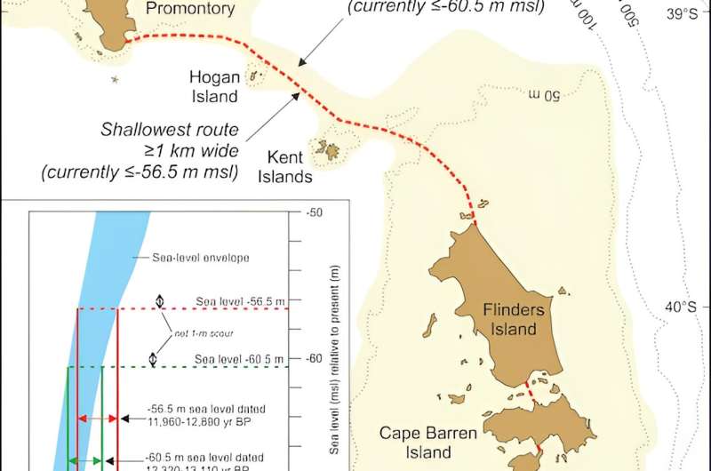
    A topographic map of the Bass Strait, showing the conditions before the Bassian Land 
    Bridge was submerged. The yellow shaded area represents geography of the land bridge,
     while the broken red line indicated the last vestige of a continuous Bassian Land Bridge 
    between Tasmania and the mainland. Credit: Patrick Nunn, Author provided

    These stories are of immense importance to today's Palawa families who survived the devastating impact of colonization, and who continue to share these unique creation stories. Through careful investigation of colonial records, and collaborating with Palawa knowledge-holders, we found something remarkable.

    Rising seas and the formation of Lutruwita

    Over the past 65,000 years, Australia's First Peoples witnessed  and significant changes to the land, sea and sky. Volcanoes spewed fire, earthquakes shook the land, tsunamis inundated the coastlines, droughts plagued the continent, meteorites fell to the earth, and the stars shifted in the night sky.

    Some 20,000 years ago, the world was in the grip of an ice age. Australia was conspicuously drier than it is today, and the ocean was significantly lower. All of that sea water was bound up in glaciers that swathed vast tracts of land, particularly across the Northern Hemisphere, and polar ice caps much larger than ours today.

    As time passed, temperatures gradually rose and the ice began to melt. After 10,000 years, the sea level had risen 125 meters; a process that dramatically transformed coastlines and submerged landscapes that had been ancestral Country for thousands of generations. This forced humans to change where and how they lived.

    During the ice age, both Lutruwita and Papua New Guinea were connected to mainland Australia by dry land, forming a landmass called Sahul. As the seas rose, Tasmania's connection gradually narrowed to form what geologists call the Bassian Land Bridge.

    People continued to live on this "", but by 12,700 years ago it had narrowed to just 5 kilometers wide (lime-green shading on the map above). Habitable land was gradually reduced as the sea closed in. Less than 300 years later, the "land bridge" was gone and Lutruwita was completely surrounded by water.

    Palawa traditions from that time survived hundreds of generations of retelling, forming part of a larger canon of Aboriginal and Torres Strait Islander stories around Australia. They described rising seas and submerging coastlines as the ice sheets melted before leveling off around 7,000 years ago. Stories of similar antiquity are known from other parts of the world.

    A great south star

    Aboriginal and Torres Strait Islander cultures developed rich and complex knowledge systems about the stars, which are still used today. They describe the movements of the Sun, Moon, and stars, as well as rare cosmic events, such as eclipses, supernovae, and meteorite impacts.

    In the 1830s, a Palawa Elder spoke about a time when the star Moinee was near the south celestial pole. He laid down a pair of spears in the sand and drew a few reference stars to triangulate its position.

    Colonists seemed perplexed about the presence of an antipodean counterpart to Polaris, as no southern pole star exists today. Some tried to identify the stars on the star map, but seemed confused and labeled them incorrectly, as they were unaware of an important astronomical process called axial precession.

    Rising seas and a great southern star: Aboriginal oral traditions stretch back more than 12,000 years
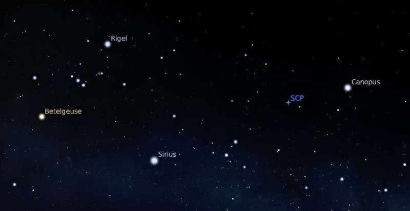
    Stars in the southern sky as they would have appeared 14,000 years ago, accounting for 
    precession, nutation, and proper motion. Canopus is very close to the south celestial pole
     (SCP). Credit: StellariumCC BY

    As the Earth rotates, it wobbles on its axis like a spinning top. This shifts the location of the celestial poles, tracing out a large circle every 26,000 years. As thousands of years pass by, the positions of the stars in the sky slowly change.

    Long ago, Canopus was at its southernmost point in the sky. Lying just over 10 degrees from the south celestial pole, it appeared to always hover in the southern skies each night. That last occurred 14,000 years ago, before rising seas turned Lutruwita into an island.

    Exciting collaborative futures

    We can see through independent lines of evidence that Palawa stories have been passed down for more than twelve millennia. We also find here the only example in the world of an oral tradition describing a star's position as it would have appeared in the sky over 10,000 years ago.

    Our investigation of colonial records that record traditional systems of knowledge has demonstrated a powerful cross-cultural way of better understanding deep human history. This also recognizes the immense value of Aboriginal and Torres Strait Islander traditions today.

    More information: Duane Hamacher et al, The archaeology of orality: Dating Tasmanian Aboriginal oral traditions to the Late Pleistocene, Journal of Archaeological Science (2023). DOI: 10.1016/j.jas.2023.105819

    Journal information: Journal of Archaeological Science 


    Provided by The Conversation 


    This article is republished from The Conversation under a Creative Commons license. Read the original article.The ConversationEvidence the oral stories of Australia's First Nations might be 10,000 years old  


    SEE

  • James Churchward - Wikipedia

    https://en.wikipedia.org/wiki/James_Churchward

    James Churchward (27 February 1851 – 4 January 1936) was a British occult writer, inventor, engineer, and fisherman. Churchward is most notable for proposing the existence of a lost continent, called "Mu," in the Pacific Ocean. His writings on Mu are considered to be pseudoscience.

    Churchward was born in Bridestow, Okehampton, Devon at Stone House to Henry and Matilda (née Gould) Churchward. James had four brothers and four sisters. In November 1854, Henry died and the family moved in with Matilda's parents in the hamlet of Kigbear, near Okehampton. Census records indicate the family next moved to London when James was 18 after his grandfather George Gould died. 

    Wikipedia · Text under CC-BY-SA license
  • THE SACRED SYMBOLS OF MU - James Churchward

    www.bahaistudies.net/.../Col-James-Churchward-The-Sacred-Symbol… · PDF file

    COLONEL JAMES CHURCHWARD AUTHOR OF "THE LOST CONTINENT OF MU" "THE CHILDREN OF MU" ILLUSTRATED IVES WASHBURN; NEW YORK Scanned at sacred-texts.com, December, 2003.

  • 3 Beards Podcast: Is the Lost Continent of Mu Real?

    Author Jack Churchward joins the show to talk about his books that cover The Lost Continent of Mu, a subject brought to life by the works of his great grandfather Col. James Churchward.

    Lifting the Veil on the Lost Continent of Mu: The Motherland of Men
    The Stone Tablets of Mu
    Crossing the Sands of Time
    are books Jack Churchward has penned to cover the works of his great grandfather and bring into focus on what is fact and what is fiction.

    The mythical idea of the “Land of Mu” first appeared in the works of the British-American antiquarian Augustus Le Plongeon (1825–1908), after his investigations of the Maya ruins in Yucatán. He claimed that he had translated the first copies of the Popol Vuh, the sacred book of the K’iche’ from the ancient Mayan using Spanish. He claimed the civilization of Yucatán was older than those of Greece and Egypt, and told the story of an even older continent.

    Col. James Churchward claimed that the landmass of Mu was located in the Pacific Ocean, and stretched east–west from the Marianas to Easter Island, and north–south from Hawaii to Mangaia. According to Churchward the continent was supposedly 5,000 miles from east to west and over 3,000 miles from north to south, which is larger than South America. The continent was believed to be flat with massive plains, vast rivers, rolling hills, large bays, and estuaries. He claimed that according to the creation myth he read in the Indian tablets, Mu had been lifted above sea level by the expansion of underground volcanic gases. Eventually Mu “was completely obliterated in almost a single night” after a series of earthquakes and volcanic eruptions, “the broken land fell into that great abyss of fire” and was covered by “fifty millions of square miles of water.” Churchward claimed the reasoning for the continent’s destruction in one night was because the main mineral on the island was granite and was honeycombed to create huge shallow chambers and cavities filled with highly explosive gases. Once the chambers were empty after the explosion, they collapsed on themselves, causing the island to crumble and sink.




    Europe's ancient languages shed light on a great migration and weather vocabulary

    Europe's ancient languages shed light on a great migration and weather talk
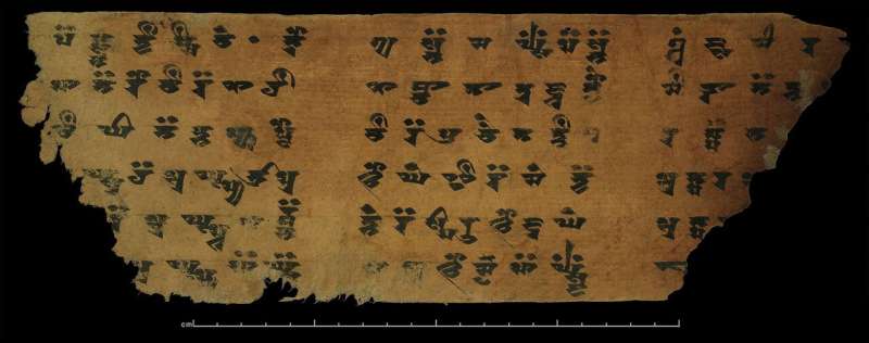
    Eastern Iranian Khotanese is among the languages that influenced ancient Tocharian. Credit: CC0 via Wikimedia Commons

    Painstaking archaeological exploration is a familiar, often widely admired, method of unearthing history. Less celebrated, but also invaluable, is the piecing together of fragments of ancient languages and analyzing how they changed over thousands of years.

    Historical linguists have reconstructed a common ancestral tongue for most of the languages spoken today in Europe and South Asia. English, German, Greek, Hindi and Urdu—among others in the Indo-European family of languages—can all trace their origins to a single spoken one named Proto-Indo-European (PIE).

    Linguistic ripples

    The language is believed to have been spoken from roughly 4,500 BC to 2,500 BC. No written traces remain.

    The people who spoke PIE probably lived in an area that is now eastern Ukraine. As groups broke away over the centuries to migrate across the continent, daughter languages stretched from Ireland to the Indian Ocean.

    Yet the pattern included a notable exception: a now-extinct branch of the Indo-European language family made its way from Europe more than 4,000 kilometers eastward to end up at the Tarim Basin in northwest China.

    Learning how and when these people, known as the Tocharians, undertook the odyssey are the goals of an EU-funded research project.

    "It gives us a fascinating insight about how far people could migrate and what sort of risks and hardships they were actually prepared to expose themselves to," said Professor Michaël Peyrot of the Center for Linguistics at the University of Leiden in the Netherlands.

    Peyrot coordinates the European project, which is called TheTocharianTrek and is due to end in December 2023 after almost six years.

    Tocharian trek

    The research is helping to pin down where the Tocharians were located in the period between 3,500 BC, when they may have left their ancestral home, and their first written history in 400 AD.

    In sum, the initiative is mapping the migration route from the PIE homeland all the way to China.

    Through the journey, the Tocharians brought their dialect of PIE into contact with people speaking different languages. This influenced and changed the way the Tocharians spoke until finally their recorded languages evolved.

    Archaeological and  suggests that the Tocharians first moved to southern Siberia.

    Peyrot and his research colleagues have sought to provide a linguistic assessment of this route. Their work reveals that, indeed, some of the quirkiest features of the language fit very well with tongues spoken in southern Siberia.

    "Languages preserve precious information about their prehistory through the effects of language contact," said Peyrot. "Observing the effects of language contact, such as borrowed words, enables us to draw conclusions about the proximity of the speakers of  and at which point in time the contact took place."

    As an example of a borrowed word, he cited a term for sword in a language strand known as Tocharian B: "kertte" was taken from "karta" in Old Iranian.

    The research team has concluded that the Tocharians arrived in the Tarim Basin in around 1,000 BC—later than was previously thought.

    As result, their window of influence in the Tarim Basin has narrowed and the Tocharians are being assigned a more muted role in the prehistory of the area than they have traditionally been given.

    Instead, the project has found a strengthened role for Iranian languages and peoples in the area, especially Khotanese, its relative Tumshuqese and Niya Prakrit. All influenced Tocharian.

    The project is also piecing together which languages left the PIE community first and when.

    As their work enters its , the researchers agree with the theory that the Tocharians may well have left the PIE family second and certainly well after the Anatolians, a group of ancient languages once spoken in present-day Turkey.

    Weather terminology

    Aside from offering insights into people's interactions and movements, comparing vocabularies in languages descended from PIE provides a picture of the material world and day-to-day life at the time.

    Much research has already been done on the family and social structure of the day, the livestock that people had and their tools in daily life.

    But few studies have examined the shared vocabulary that these ancient peoples used when talking about something that is an equally popular topic of conversation today: the daily weather.

    Dr. Julia Sturm is combing through the lexica of ancient languages to pull out any words relating to weather and climate as part of another EU-funded project—IE CLIMATE—that she leads.

    "It's important to have many perspectives on how we relate to climate and how we experience ourselves in the world," said Sturm, a postdoctoral fellow with the Roots of Europe Center at the University of Copenhagen in Denmark.

    The European project is due to wrap up in October 2023 after two years.

    The work has involved scrutinizing the written evidence of 10-plus Indo-European languages to find, for example, a word to convey cloud and then piecing together conclusions and timeframes about how one tongue influenced another.

    Word atlas

    The ultimate goal is to create an atlas that maps where the words were used and when. The completed atlas is due to be available on the university's website beginning in late 2023.

    While an archaeologist digs up  at historical sites, Sturm combines formal linguistics and philology—the study of  in written and oral historical sources—to "excavate" words.

    In both cases, the aim is to draw conclusions about the material world of the distant past.

    Carried out in tandem with paleoclimatology, which is the study of climatic conditions in different periods of history, Sturm's work gives new insights into the weather of the past and people's attitudes towards it.

    The persistence of metaphor is striking: how humans have personified elements in the natural world and related to them.

    Greek, Latin and Vedic Sanskrit, for instance, all describe gods as wearing clouds, using the same verb to depict how people might don a shawl or a cape.

    "The more information we have about geography and time, the better," said Sturm. "In a world where the climate is changing so much and we are realizing our role in the system, looking at the past brings an important new perspective."

    More information:


    A rarely seen whale has died in the Florida Keys, and biologists are investigating

    whale
    Credit: Unsplash/CC0 Public Domain

    Marine mammal scientists are investigating the cause of death of a rarely seen whale found in the shallow waters of the Florida Keys.

    Bystanders saw the animal struggling in about two to three feet of water around Harry Harris Park, a small oceanfront park in Tavernier, around 4 p.m. Sunday and called the Florida Fish and Wildlife Conservation Commission. The agency then contacted the federally sanctioned whale stranding response nonprofit, Dolphins Plus Marine Mammal Responder, which dispatched a team within 30 minutes.

    But it was too late.

    The 14-foot long animal, an adult male Gervais' beaked whale, had died, said Art Cooper, a biologist and founder of Dolphins Plus Marine Mammal Responder.

    Fish and wildlife officers towed the whale to a local marina where it stayed until it was taken to a U.S. Park Service station in Key Largo, where scientists conducted their necropsy—an autopsy for animals—on Monday beneath tents set up under a canopy of trees over a boat ramp.

    The scientists took measurements before eventually cutting into its body to take samples and to inspect for possible injuries or signs of illness or injury.

    Cooper said it's too early to tell what happened to the whale. But so far, there's nothing obvious to indicate that it was related to human activity such as a boat strike.

    "I think this is an older animal," Cooper said.

    He surmised this because the whale's torso was covered in dark polka dot-looking circles that Cooper said were scars from cookie-cutter shark bites. The small sharks have round mouths lined with razor sharp teeth. When they bite, they leave circular wounds and remove inverted ice cream cone shaped pieces of flesh, Cooper said.

    "It takes a long time to heal," Cooper said. "If you look at this guy's belly, he's been around for a while."

    Gervais' beaked  can live between 27 and 48 years, according to the National Oceanic and Atmospheric Administration. Since they prefer very , they are rarely seen in the shallower water that surrounds the Florida Keys.

    "I've been doing this 33 years," Cooper, 54, said. "This is the third beaked whale I've seen."

    Despite the initial indication this whale died of old age, National Marine Fisheries Service officials wanted Cooper's team, which worked with FWC biologists, to conduct the necropsy because this was the second pelagic—or —whale to be found dead off the Keys in less than a week, he said.

    Last week, a large dead sperm whale was reportedly spotted about 40 miles off the Middle Keys city of Marathon, Cooper said.

    Scientists never got a chance to inspect the animal because predators had gotten to its carcass, eventually eating its stomach. When that happens, the mammals sink, Cooper said.

    Apart from the initial necropsy done at the Park Service's station, much of the other parts of the animal will be tested elsewhere by scientists, and the skull will undergo a CT scan at the National Marine Fisheries Service's lab in Key Biscayne , Cooper said.

    The rest will be returned to the water, where Cooper said animals like bull sharks, commonly found in the shallows off the Keys, will likely devour the carcass in a matter of hours.

    "Since this animal was not euthanized," he said, "we can recycle the carcass and whatever part we're not scientifically interested in."

    2023 Miami Herald. Distributed by Tribune Content Agency, LLC.


    Fishing gear and plastic bag pieces found in the stomach of a dead sperm whale in Keys


    New research offers solutions to improve drinking water access in developing countries

    water Africa
    Credit: Pixabay/CC0 Public Domain

    New research from Alfonso Pedraza-Martinez, the Greg and Patty Fox Collegiate Professor of IT, Analytics and Operations in the University of Notre Dame's Mendoza College of Business, examines the critical problem of drinking water access in rural areas of developing countries and recommends optimal locations to build new water projects.

    The work, titled "Improving Drinking Water Access and Equity in Rural Sub-Saharan Africa," forthcoming in the journal Production and Operations Management, studies access to drinking  in Tigray, Ethiopia, where millions of people walk hours each day to access communal water. The study, co-authored by Chengcheng Zhai, Kurt Bretthauer and Jorge Mejia from Indiana University, pulls from  conducted in Tigray and collaborations with local and international NGOs.

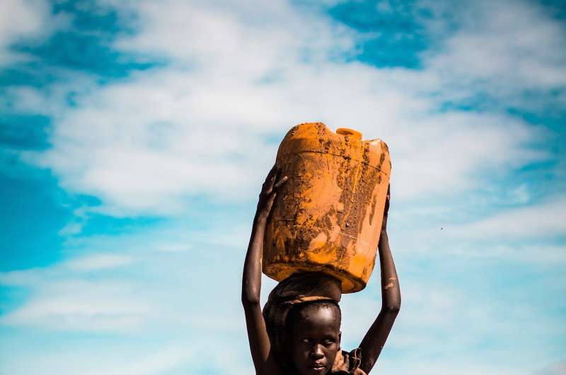
    "The burden of getting water falls mostly on women and children," said Pedraza-Martinez, who specializes in humanitarian operations and disaster management. "It is not rare to see a woman accompanied by her children carrying a heavy jerrycan full of water back home in the scorching hot weather."

    Due to a lack of local government solutions, NGOs build water projects that extract underground water to reduce the population's distance and time to access it. In collaboration with U.S. NGO Charity: Water and Ethiopian NGO Relief Society of Tigray, the team worked to understand the roles of the different stakeholders.

    "Building water projects is expensive and funding is scarce," Pedraza-Martinez said. "NGOs must select locations for new water projects while navigating tight budget constraints and very limited access to data on demand locations.

    "We discovered that communities actively participate in the management of existing water projects, so we propose that two neighbor communities collaborate, pooling their demand, to increase the potential supply for both communities."

    The team created a unique dataset with current demand and distance to an existing water  in Tigray. Using analytics, they built an optimization or ideal solution (centralized model) that incorporates community collaboration, and compared its solutions with the  that serves each community separately.

    The community collaboration model proved to be a better solution—in terms of distance to water and equity in the access to water—than the other models they considered. The "minimax" model adjusted the objective to minimizing the maximum distance to water and the equitable allocation model adjusted the current per capita budget allocations to assign more budget to beneficiaries who are further from water.

    "When Ethiopian communities (kebeles) collaborate to access water as a single, larger community, it removes geopolitical boundaries for water purposes," Pedraza-Martinez said. "It gives people who live on the outskirts of one kebele the option of walking a shorter distance toward another to use a hand pump or other water source, rather than walking a longer distance to find one in their own kebele. If there is cooperation, this solution is very effective to reduce distance and increase equity."

    Motivated by Ethiopia's current civil war, the team also created a model to study ways to improve drinking  amid supply shocks.

    The team is sharing its findings with Charity: Water, which is using the new model to inform the selection of locations for new water projects in Malawi and the Central African Republic, along with other countries. They also plan to publish a pedagogical case study to share their research findings with MBA programs around the world.

    More information: Chengcheng Zhai et al, Improving drinking water access and equity in rural Sub‐Saharan Africa, Production and Operations Management (2023). DOI: 10.1111/poms.14016


    Provided by University of Notre Dame Billions still lack access to safe drinking water—this is a global human rights catastrophe, says researcher