Researchers use autonomous technologies to make mines safer
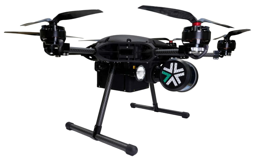
IMAGE: VIRGINIA TECH RESEARCHER RICHARD BISHOP CONTINUES TO DEVELOP AUTONOMOUS TECHNOLOGIES TO ASSESS AND PREDICT THE SAFETY OF UNDERGROUND MINES. THIS WORK ALSO PROVIDES OPPORTUNITIES FOR MINING AND MINERALS ENGINEERING STUDENTS TO GAIN HANDS-ON EXPERIENCE IN NEW TECHNOLOGIES. PHOTO BY RICHARD BISHOP FOR VIRGINIA TECH. view more
CREDIT: VIRGINIA TECH
How do you use drones and robots to make underground mining less risky for workers?
Virginia Tech researcher Richard Bishop and his West Virginia University collaborators are working to answer this question. A recent two-year, $569,149 Alpha Foundation grant will allow the team to study ways to use autonomous drones to predict and prevent roof collapses underground.
It’s urgent work. Since 2006, about 40 percent of deaths in underground stone mines in the U.S. have been linked to collapsed roofs and rock pillars. In fact, four major collapses have occurred in older sections of mines since 2020. What’s more, there exists no definitive way to predict these structural failures.
“We hope that by bringing our research together, we can make faster progress in this critically important area of mine safety,” Bishop said.
The project aims to develop a database of mine layouts, rock mass characteristics, and high-resolution 3D maps of stone mine pillars and roofs; refine the techniques and equipment used to gather similar data; and use the database to develop guidelines for recognizing hazards that lead to pillar and roof collapses.
Bishop, who is an alumnus of the Department of Mining and Minerals Engineering, previously worked on a research project funded by the National Institute for Occupational Safety and Health that used laser scanning and a photographic technique known as photogrammetry to generate 3D maps to help study the structural integrity of underground stone mines. In that project, Bishop demonstrated the effectiveness of using various sensors to fly drones in GPS-denied environments and onboard LED lighting systems, built in-house, to allow drones in the absolute darkness of an underground mine to capture high-quality digital photos. Those photos were used to calculate critical measurements to evaluate the safety of mine structures.
West Virginia University researchers have developed a robotic mapping system that uses autonomous ground and aerial vehicles to map underground mines. Bringing these two approaches together could develop better ways to inspect mine structures and predict safety threats.
Drones have become an essential part of surface mine operations to boost safety and efficiency. Bishop sees a day when that will be true for underground operations, too, and that could have broad impacts on safety and economic growth. The global stone mining and quarrying market alone is expected to grow from about $8 billion in 2020 to more than $11 billion by 2025, Business Wire recently reported.
That growth also provides opportunities for today’s mining students that the College of Engineering wants to help them seize.
“All our mining engineering students now and in the future will have opportunities to learn and practice using autonomous technologies for a range of applications,” interim department head Erik Westman said. “We currently have a near 100 percent job placement rate for our graduates. We want to ensure our degree program stays on the cutting edge of mining and remains a great financial investment for students and their families.”
Westman oversees the department’s new Center for Autonomous Mining, aka VT Mock Mine, in the recently remodeled Holden Hall. The first-of-its-kind lab-scale facility features three open pits that can be filled with various minerals and space soil simulants. There, students build and operate autonomous digging and hauling vehicles for classes and competition teams. Bishop also teaches students to build and fly small drones in the facility, and Westman plans to develop research initiatives that would include industry partners.
“Our undergraduate program is focusing on providing training in data analytics and programming to help our graduates and industry partners leverage the financial and environmental efficiencies possible now and in the future,” Westman said.
This focus on education and hands-on experience with autonomous technologies will not only make mining engineering graduates more sought after by employers, it will give them the tools to make important contributions to the safety and sustainability of mining worldwide.
Moosa Imran| May 30, 2023 | Canadian Mining Journal Staff
For Exyn Tech, the number one thing in drone design is safety. The ExynAero EA6 is a fully autonomous drone, able to map existing stops and/or drifts. It does not require any sort of previous infrastructure, GPS, tethers, Wi-Fi, or even a pilot.
“We no longer need to send miners to the face,” said Raffi Jabrayan, VP business development and commercial sales. “With our machines, you could stand 30, 40, or 50 metres away from an open stope, under a fully supported area, give it its mission and it is able to go and get the mission done.”
Jabrayan said that among its other attributes, efficiency was key, claiming that the drone can complete research within a mine that would normally take hours, within a matter of minutes.
On top of that, the EA6 is changing the game in terms of map accuracy.
“Your traditional measuring tools used to give you 30,000 to 40,000 points. (EA6) gives you 50 million to 60 million points. In layman’s terms; it is giving you a
better-quality map, which is giving you more accurate volumetric calculations, which then allows you to obviously plan better,” he said.
The EA6 is the third generation of autonomous drones from Exyn. The company was founded in 2014 by Nader Elm and Vijay Kumar as a spin off, out of the University of Pennsylvania’s General Robotics, Automation, Sensing and Perception (GRASP) lab.
Jabrayan said that bringing major mining corporations into the development process was vital for the development of the EA6, as it was for previous models. Products are also rigorously tested in controlled environments before they hit the market.
According to Jabrayan, reviews for the item have been largely positive and over 150 units are out in the marketplace right now.
“It is very difficult for me to say, no, we do not want something that’s going to make us more efficient, or we do not want to be safer, or we don’t want more accuracy. So, the product usually sells itself,” he added.
Jabrayan said the next step in the drone’s evolution is to optimize functionality. Be that longer battery life, more sensors, an increased ability to detect gases and eventually making the drone suitable for indoor and outdoor flight, as opposed to its current setting which is exclusively for underground.
“Before the end of the year, this unit will be able to fly indoor and outdoor at the same time. It can start indoors and finish outdoors or vice versa, which opens a whole bunch of new use cases,” Jabrayan said.
Exyn Technologies is known for pioneering AI autonomous aerial robot systems for complex, GPS-denied environments.
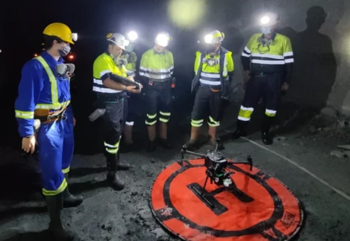
Safely and quickly map underground openings with the Exyn Aero autonomous drone. Exyn Technologies photo
Exyn Technologies is known for pioneering AI autonomous aerial robot systems for complex, GPS-denied environments. Geologists at Ascot Resources have used the Exyn Aero fully autonomous drone to map a former underground mine that was in production from 1938 to 1941. The result was an accurate map delivered quickly and safely.
In the past, human surveying teams have been sent into old mines such as the Big Missouri deposit that Ascot used Exyn technology to survey. Not only is this human powered methodology inefficient its also unsafe and tends to result in slow data and mistakes in mapping of capabilities.
The Big Missouri deposit is part of the former Premier gold mine that Ascot is seeking to reopen. The first gold pour is scheduled for early 2024. The mine site is 25 km from the town of Stewart, B.C.
The Exyn Aero fully autonomous drone can map a mine such as this in a matter of minutes thanks to LiDAR based mapping technology. This data can allow companies like Ascot to quickly create reports of existing mine openings that were previously impossible.
Request a demonstration of any Exyn technology at www.Exyn.com.
No comments:
Post a Comment