Monday, May 27, 2024


Are some routes more prone to air turbulence? Will climate change make it worse? Your questions answered
Are some routes more prone to air turbulence? Will climate change make it worse? Your questions answered
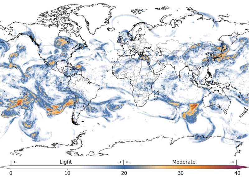
A map of estimated clear-air turbulence around the world, current as of 3:00PM AEST
 (0500 UTC) on May 22 2024. Credit: Turbli

A little bit of turbulence is a common experience for air travelers. Severe incidents are rare—but when they occur they can be deadly.

The recent Singapore Airlines  SQ321 from London to Singapore shows the danger. An encounter with extreme turbulence during normal flight left one person dead from a presumed heart attack and several others badly injured. The flight diverted to land in Bangkok so the severely injured passengers could receive hospital treatment.

Air turbulence can happen anywhere, but is far more common on some routes than on others.

Climate change is expected to boost the chances of air turbulence, and make it more intense. In fact, some research indicates turbulence has already worsened over the past few decades.

Where does turbulence happen?

Nearly every flight experiences turbulence in one form or another.

If an aircraft is taking off or landing behind another aircraft, the wind generated by the engine and wingtips of the lead aircraft can cause "wake turbulence" for the one behind.

Close to ground level, there may be turbulence due to  associated with  moving through the area near an airport. At higher altitudes, there may be wake turbulence again (if flying close to another ), or turbulence due to updraughts or downdraughts from a thunderstorm.
Are some routes more prone to air turbulence? Will climate change make it worse? Your questions answered
Credit: The Conversation

Another kind of turbulence that occurs at higher altitudes is harder to predict or avoid. So-called "clear-air turbulence" is invisible, as the name suggests. It is often caused by warmer air rising into cooler air, and is generally expected to get worse due to e.

At the most basic level turbulence is the result of two or more wind events colliding and creating eddies, or swirls of disrupted airflow.

It often occurs near , as wind flowing over the terrain accelerates upward.

Turbulence also often occurs at the edges of the jet streams. These are narrow bands of strong, high-altitude winds circling the globe. Aircraft often travel in the jet streams to get a speed boost—but when entering or leaving the jet stream, there may be some turbulence as it crosses the boundary with the slower winds outside.

What are the most turbulent routes?

It is possible to map turbulence patterns over the whole world. Airlines use these maps to plan in advance for alternate airports or other essential contingencies.

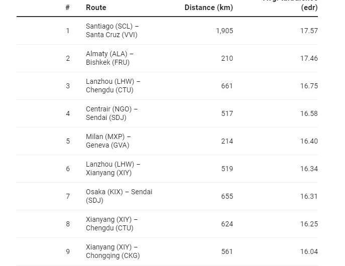
While turbulence changes with weather conditions, some regions and routes are more prone to it than others. As you can see from the list below, the majority of the most turbulent routes travel close to mountains.

In Australia, the highest average turbulence in 2023 occurred on the Brisbane to Sydney route, followed by Melbourne to Sydney and Brisbane to Melbourne.
Are some routes more prone to air turbulence? Will climate change make it worse? Your questions answered
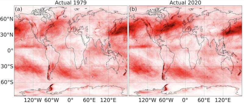
A map showing changes in the chance of clear-air turbulence across the globe between 
1979 and 2020. Darker red indicates a higher chance of turbulence. 
Credit: Prosser et al. (2023), Geophysical Research Letters

Climate change may increase turbulence

How will climate change affect the future of aviation?

study published last year found evidence of large increases in clear-air turbulence between 1979 and 2020. In some locations severe turbulence increased by as much as 55%.

In 2017, a different study used climate modeling to project that clear- may be four times as common as it used to be by 2050, under some climate change scenarios.

What can be done about turbulence?

What can be done to mitigate turbulence? Technology to detect turbulence is still in the research and development phase, so pilots use the knowledge they have from  to determine the best plan to avoid weather patterns with high levels of moisture directly ahead of their flight path.

Weather radar imagery shows the pilots where the most intense turbulence can be expected, and they work with air traffic control to avoid those areas. When turbulence is encountered unexpectedly, the pilots immediately turn on the "fasten seatbelt" sign and reduce engine thrust to slow down the plane. They will also be in touch with air traffic control to find better conditions either by climbing or descending to smoother air.

Ground-based meteorological centers can see weather patterns developing with the assistance of satellites. They provide this information to flight crews in real time, so the crew knows the weather to expect throughout their flight. This can also include areas of expected turbulence if storms develop along the intended flight route.

It seems we are heading into more turbulent times. Airlines will do all they can to reduce the impact on planes and passengers. But for the average traveler, the message is simple: when they tell you to fasten your seatbelt, you should listen.

Provided by The Conversation 

This article is republished from The Conversation under a Creative Commons license. Read the original article.The Conversation


Chamber pots, shared toilets and DIY plumbing: China's toilet revolution exposes social inequalities

Chamber pots, shared loos and DIY plumbing: China's toilet revolution exposes social inequalities
Credit: Deljana Iossifova

Urbanization in China tends to be depicted in terms of towering skyscrapers and multilane highways—the city reaching upwards and outwards. Not much thought is given to the vast, but less eye-catching, urban infrastructure that shapes and is shaped by the everyday lives of its citizens—such as toilets and sewers.

Until as late as the 2010s, chamber pots were still a common feature of urban life in China. Families shared wooden matong buckets or enamel tanyu, and emptied them at communal disposal sites. The waste thus collected was transported to suburban and rural areas for agricultural use.

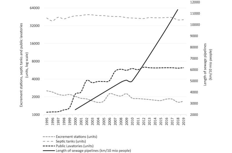
In 2015, President Xi Jinping launched the nationwide toilet revolution. By 2020, city councils had added 68,000 more ; by the end of 2022, 73% of rural residents reportedly had access to flush toilets.

But, as research has long shown, urban development and access to the modern sanitation it brings is unequal. When a poorer neighborhood is slated for redevelopment, indoor plumbing is often not considered a priority.

Residents in older, poorer urban areas continue to rely on chamber pots and neighborhood waste collection services. And not all newer areas are connected to the municipal sewage network either; some depend on septic tanks that have to be frequently emptied.

Attitudes, too, are shifting slowly. In newer and older neighborhoods alike, local residents often attribute poor sanitary conditions in public spaces to migrant populations. This leads to discrimination and sometimes even intimidation.

Our recent study looks at how sanitation in the east coast city of Shanghai is shaped by socioeconomic inequality. We have found that it isn't just about cleanliness—sanitation is also about power, culture and social norms.

Everyday sanitation practices

Between 2019 and 2022, our research team visited six diverse neighborhoods in the heart of Shanghai, conducting interviews with 54 residents of different genders, ages and places of origin. We wanted to understand how cultural and social norms are embedded within people's daily hygiene practices, and to what extent existing sanitation infrastructure meets their needs. We also wanted to see what inequalities both this infrastructure and people's routines create and recreate.

We found that sanitation practices are not just about biological rhythms, but the rhythms of everyday life. Residents who do not have flush toilets at home have to schedule visits to public bathrooms in between shopping, going for walks and exercise.

In other older neighborhoods, instead of public bathrooms, multiple households in a building or on the same lane might share a toilet. Residents have to plan their visits to avoid busy times, before and after work.

In some older neighborhoods and those slated for redevelopment, people continue to use chamber pots. They empty them at collection stations twice a day, in the morning before heading to work and in the evening before going to bed.

Rapid urbanization in China has brought unprecedented numbers of migrants into Shanghai and other cities from the countryside. The long-term residents of older neighborhoods we spoke to said repeatedly that these rural-to-urban migrants, who are often overworked and starved for time, do not always follow local customs when disposing of their waste.

Some might, for example, cover their chamber pots with plastic bags and dispose of the contents, bag and all, at the collection stations. This has often led to blockages and overflows, which represent a significant public health hazard. As one resident, migrant worker Lou*, put it: "Urbanites blame  for making public toilets dirty."

In turn, migrant workers are critical of the people in these older neighborhoods who still use chamber pots. In their home villages and towns, this old-fashioned system—which they consider backwards—has long been replaced by private or shared toilets.

Sanitation infrastructure in Shanghai, 1995–2019

Public or shared toilet blocks sometimes lack the facilities women need, including menstrual waste disposal. When Zhu, a 25-year-old migrant worker, was pregnant, she said she felt helpless because the public bathroom was equipped with urinals only, not toilets with seats. This led her husband to install a private flush toilet inside their rented home.

DIY toilet installation—tolerated by local authorities—is common practice. However, these toilets are often connected directly to storm water sewers, which can lead to unpleasant odors, sewage overflow and, potentially, drinking water contamination.

When connected to septic tanks, there are other challenges. Yu, a 70-year-old local resident, pointed to the economic disincentives at work. Instead of emptying them completely, she said sanitation workers seem to prefer to increase the frequency of their visits. Doing so is more profitable.

The shift to water-based, sewer-networked sanitation and chemical fertilizers in agriculture has decreased the value of human waste. Sanitation professionals are no longer interested in maximizing the amount of waste they collect.

Private flush toilets are typically more common in affluent neighborhoods. This has brought about new social norms and hygiene practices. Men and boys are expected to put the toilet seat down after urination for the convenience of women and girls. Parents use toilet seat covers to prevent the transmission of pathogens through children's direct contact with water or droplets from flushing.

Qiu, a 33-year-old man, said having his first child changed the way he thought about : "My wife's careful selection of hygiene products for our baby made us more conscious of personal hygiene."

As a result of these changing attitudes, hygiene products—wipes, tissues, seat covers—have become increasingly popular. This has obvious implications for the increased production and disposal of (solid) waste.

Even in neighborhoods where people have access to private toilets, however, chamber pots have not disappeared entirely. Yu told us that her elderly neighbors tend to still keep one by their bedside.

This is not only a matter of convenience but nostalgia and cultural heritage. Traditionally, the humble chamber pot—also known as zisun tong, or offspring pot—is an item of value for Han people, given as a wedding present by the bride's family. In a rapidly changing world, it continues to resonate with meanings beyond personal hygiene.

*All names in this article have been changed to protect the interviewees' anonymity.

Provided by The Conversation 

his article is republished from The Conversation under a Creative Commons license. Read the original article.The Conversation


International development can tackle the climate and migration crises together


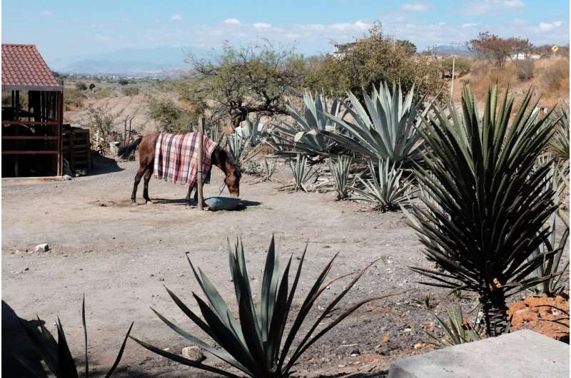
farm mexico
Credit: Unsplash/CC0 Public Domain

Without immediate action to help the world's most vulnerable people adapt to climate change, millions face the prospect of their homes becoming unlivable, with no option but to leave.

Take the "dry corridor" of Central America, which stretches from Nicaragua in the south to the Mexican border in the north. Home to nearly 12 million people, the region is in the throes of yet another mega-drought. Recent heat waves here have lasted months, sparking winter wildfires and drying up freshwater and soils.

The consequences, which have yet to be fully realized, will almost certainly include major crop losses and food shortages that could spur violent conflict and mean more desperate families on the move.

Yet, by researching nature-friendly forms of farming rooted in the region's Indigenous cultures (often referred to collectively as agroecology), I've learned that extreme weather needn't end in tragedy. The right kind of actions can help people adapt to and even mitigate climate change, while giving them economic incentives to keep them from migrating.

A green economy in action

Since 2009, I've worked in the Maya-Achi territory in central Guatemala. Like elsewhere in the Dry Corridor, climate change has increased the frequency of heat waves at all times of year here and made wet seasons more erratic. As a result, small-scale agriculture, the principal livelihood, is extremely difficult.

Climate change has also exacerbated existing problems, such as inequality, the dependency of farmers on expensive and polluting chemical fertilizers and fallout from the civil war of the 1980s which tore communities apart. These factors have caused an exodus of young people from the region in search of opportunities elsewhere.

I've learned a lot from the Maya Achi, an ethnic group indigenous to Guatemala. I've discovered how ancestral knowledge about the local ecology can promote healthy soil management. I have seen how community organizations contribute to sustainable livelihoods, with programs that restore and in some cases reintroduce native foods and crop varieties, such as heritage maize and amaranth, which experts have found to be drought-tolerant and highly nutritious.

I've also witnessed the success of local groups in coordinating hundreds of Indigenous families to pursue agroecology, which includes regenerating degraded forests and watersheds. This has allowed farmers to grow more food as the prevalence of shade, moisture and healthy soil has improved, making small-scale farming more viable.

It's no secret that strong social networks help boost resilience in agricultural communities. In our recent article, education scholar Michael Bakal and I argued that Maya-Achi organizations, such as Qachuu Aloom, a local farmer and seed-saving association, are ideally placed to take on the climate and migration crises.

Not only do these organizations understand the needs and values of their communities, they also advance a model of economic development that enhances rather than destroys the environment—precisely the kind of green economy that is being called for internationally.

Each year, billions of dollars are spent globally on development projects which are supposed to improve conditions in areas like the Dry Corridor. Increasingly, funds are earmarked for building resilience to climate change, including farming projects that introduce new technologies, crops and practices.

As useful as some of these efforts have been, in the Maya-Achi territory, many programs initiated by foreign governments and charities have not left a positive legacy. Often this is due to a lack of consultation with local people and , the continued gifting of chemical fertilizers and non-native seeds which farmers become dependent on and the use of food aid, which is often unnecessary and culturally insensitive, disrupting as it does local food production and diets.

I have also heard criticisms from family farmers about the unrealistic expectations from simplistic (though expensive) projects that last, at most, two years. As one community leader put it: "They give us a shovel and expect everything to change overnight."

Not all international assistance and development programs have failed to improve local conditions. Yet, it's clear that to meet the urgency of the climate and migration crises, a change is needed. Some researchers insist that governments subsidize agroecological farming in areas hard hit by climate change, and that traditional and Indigenous techniques and crop varieties be at the heart of national campaigns to make communities more resilient.

Instead of importing ideas and projects to climate-vulnerable regions, we propose a new vision of development based on the values and well-being principles of local and Indigenous communities. This would mean development rooted in healthy food and farming landscapes, tight-knit communities of mutual support, and reverence for nature—principles originating from the philosophy of Buen Vivir, also called "Utziil Kasleem" in the Maya-Achí language.

As hundreds of millions of US dollars become available for development, with schemes aimed at tackling migration at its source, there is enormous potential to support local climate action: reforestation and agroecological farming, new markets for local products and ancestral practices blended with newer technologies, helping farmers adapt to changing conditions. An example might be improved composting methods and biological fertilizers derived from leaves and crop residues.

Development aid raised internationally could be much better spent by mitigating  and helping vulnerable communities stay together. Wealthy nations and organizations must listen to and learn from local people, supporting their existing projects and allowing them to reach their potential.

Provided by The Conversation 

This article is republished from The Conversation under a Creative Commons license. Read the original article.The Conversation


Study maps human uptake of microplastics across 109 countries

Study maps human uptake of microplastics across 109 countries
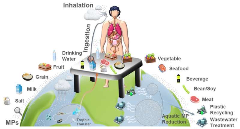
Dietary and airborne MP uptake pathway overview and uptake reduction by water quality
 control aided by aquatic plastic debris removal in 109 major developing and industrialized
 countries.
 Credit: Environmental Science & Technology (2024). DOI: 10.1021/acs.est.4c00010


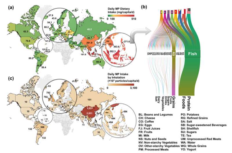
Southeast Asian countries such as Indonesia, Malaysia and the Philippines top the global per capita list of dietary uptakes of microplastics, while China, Mongolia and the United Kingdom top the list of countries that breathe the most microplastics, according to a new study by Cornell researchers mapping microplastic uptake across 109 countries.

The study, published April 24 in the journal Environmental Science & Technology, builds on existing data models estimating how much  humans unwittingly eat and inhale as a result of untreated plastic debris degrading and dispersing into the environment.

To more comprehensively estimate , the Cornell study accounts for each country's eating habits, food processing technologies, age demographics and breathing rates—all factors that contribute to differences in how residents of each country consume microplastics.

"The uptake of microplastics at the country level is a critical indicator of plastic pollution and public health risks," said Fengqi You, the Roxanne E. and Michael J. Zak Professor in Energy Systems Engineering, who co-authored the study with doctoral student Xiang Zhao. "Comprehensive global mapping supports local pollution mitigation efforts through enhanced water quality control and effective waste recycling."

The study assesses dietary uptake by compiling data on microplastic concentrations in subcategories of major food groups such as fruits, vegetables, proteins, grains, dairy, drinks, sugars, salt and spices. The models also use data detailing how much of those foods are consumed in different countries. For instance, table salt consumption, per capita, is about equal in Indonesia and the U.S., but the microplastic concentration in Indonesian table salt is around 100 times higher.

Overall, the study found that Indonesians eat about 15 grams of microplastics per month—more than any other country—with the majority of plastic particles coming from aquatic sources such as seafood. That is a 59-fold increase in daily microplastic consumption from 1990 to 2018, the date range used for the models. U.S. dietary intake of microplastics is estimated to be about 2.4 grams per month, while the lowest is Paraguay at 0.85 grams.

Study maps human uptake of microplastics across 109 countries
Per capita daily MP dietary and inhalation uptake rates at the country level in 109
 industrialized and developing countries within Asia, Europe, Africa, and North and 
South America, focusing on the world’s major coastlines that are affected by plastic 
pollution. 
Credit: Environmental Science & Technology (2024). DOI: 10.1021/acs.est.4c00010


Data on airborne microplastic concentration, age demographics and human respiration rates were used to calculate microplastics being inhaled. Residents of China and Mongolia topped the list, breathing in more than 2.8 million particles per month. U.S. residents inhale about 300,000 particles per month. Only residents in the Mediterranean and nearby regions breathed less, with countries like Spain, Portugal and Hungary breathing about 60,000 to 240,000 particles per month.

"Industrialization in developing economies, particularly in East and South Asia, has led to increased consumption of plastic materials, waste generation and human microplastic uptake. Conversely, industrialized countries are experiencing a reverse trend, supported by greater economic resources to reduce and remove free plastic debris," said You, who is a senior faculty fellow at the Cornell Atkinson Center for Sustainability.

You added that the study can inform reduction strategies for microplastic uptake that are tailored to local economies and industrial contexts, but that such efforts require , such as technology support from developed countries to advance waste reduction strategies.

According to the study, a 90% reduction in aquatic plastic debris could lead to substantial decreases in microplastic exposure, potentially by up to 51% in developed countries and 49% in highly industrializing regions.

The study was published on the heels of an April 23–29 meeting of an international committee negotiating the U.N. Plastics Treaty, a legally binding agreement that would establish global rules around  production and disposal. The agreement is expected to be finalized later this year, with a focus on international collaboration to reduce microplastics in marine environments.

"Cleaning the global surface water system is a marathon influenced by local industrial and socioeconomic settings," Zhao said. "However, our global map that pinpoints aquatic microplastic hotspots can initiate this journey, and our study highlights that addressing microplastic uptake requires a multifaceted approach, including sustainable packaging solutions, enforcing stringent waste management regulations and advancing water treatment technologies."

More information: Xiang Zhao et al, Microplastic Human Dietary Uptake from 1990 to 2018 Grew across 109 Major Developing and Industrialized Countries but Can Be Halved by Plastic Debris Removal, Environmental Science & Technology (2024). DOI: 10.1021/acs.est.4c00010

Journal information: Environmental Science & Technology 

Provided by Cornell University Every breath you take: Following the journey of inhaled plastic particle pollution

A Million-Year-Old Skull Could Prove the Dragon Man’s Direct Line to Humans

The plot thickens in the saga of our evolution.

PUBLISHED: MAY 22, 2024
Junatura//Getty Images

A reconstruction of an ancient Chinese skull may tie the Dragon Man lineage even closer to Homo sapiens.

Scientists have revealed potential ties between Denisovans, Dragon Man, and Yunxian Man lines.

Potential links between the archaic humans and Homo Sapiens are still a source of intrigue.

The exact ties between archaic human lines and Homo sapiens may remain unknown, but a recent effort to analyze ancient Chinese skulls potentially just brought those links closer together.

To better understand the growth of the Homo family—and specifically where H. sapiens fits into the history of the world—researchers have long studied other Homo lines. This research has led them to investigate lineages ranging from the relatively well-known Denisovans to lesser-known lines based on just a few found skulls, such as the Dragon Man and Yunxian Man lineages from China.

Proof of First Trek from Africa to Australia

With some of the found skulls potentially being 1 million years old, there isn’t exactly a wealth of data to go off, so a team of researchers reconstructed one of three Yunxian Man skulls from what is believed an unknown human species from the Yunyang District of Hubei province in Central China. The findings—published on the non-peer-reviewed pre-print server bioRxiv—claim that this ‘Yunxian 2’ skull just might be of the same lineage as the Dragon Man, and potentially one of the last common ancestors of H. sapiens

“It is very controversial whether these fossil humans represent different species or lineages,” the authors wrote in the study. “The 1-million-year-old Yunxian 2 fossil from China is crucial for understanding the cladogenesis of Homo and the origin of Homo sapiens.”

Using new technology, the team restored and reconstructed the cranium, and the results suggested that whoever this skull used to belong to was “an early member of the Asian ‘Dragon Man’ lineage, which probably includes the Denisovans, and is the sister group of the H. sapiens lineage.”

The team said that both the H. sapiens and Dragon Man lineages having deep roots extending beyond the Middle Pleistocene age, and the Yunxian fossil cranium “suggests it represents a population lying close to the last common ancestor of the two lineages.”

Ancient Cave Paintings Held Astronomical Readings

Some researchers believe that the Homo lines eventually diverged. In that split, the Denisovans—which could have included both the Dragon Man and Yunxian Man lines—wenr extinct, while the H. sapiens line continued to evolve into modern humans. Those sister lines have a long history of interaction until they don’t, and finding that point of divergence has so far eluded scientists.

To complicate the effort beyond having so few fossils to work with, the Yunxian Man fossil is believed to be roughly 1 million years old—much older than either the Dragon Man or H. sapiens. Still, it could mean that Yunxian Man offers a common link, as an ancestor of sorts, between the Dragon Man and H. Sapiens.

“It is reasonable to conclude,” the authors wrote, “that Yunxian is morphologically and chronologically close to the last common ancestor of the lineages of H. sapiens and Dragon Man.”


Researchers track secret Russian missile launchers in Ukraine using public satellite data

We tracked secret Russian missile launchers in Ukraine using public satellite data
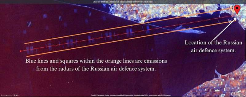
The interference signature of an S-300 system in the Kherson Oblast, a Russian-occupied
 region of Ukraine. Credit: ESA/Tom Saxton

In the occupied far east of Ukraine, Russian forces are aiming waves of missiles against Ukrainian civilian targets. Each of Russia's state-of-the-art missile launch systems costs more than US$100 million (A$150 million). They allow Russia to launch attacks from safe positions many kilometers behind the front lines.

The S-300 surface-to-air missile launcher is designed to avoid detection. Their locations are closely guarded secrets. However, using publicly available satellite images, we have detected telltale signs of the operation of these weapons that give away their location.

This is just one example of why the strategic and tactical use of publicly available data on the internet has become an increasing source of concern for militaries. So-called " intelligence" (or OSINT) has become a top priority of intelligence agencies worldwide.

As more and more data is digitized and placed online, open-source intelligence has become a powerful tool. Social media platforms,  and leaked data can all be sources of intelligence information.

We have seen significant use of open-source intelligence via social media in the Ukraine conflict. The movements of soldiers and military vehicles have been widely documented. Russian information operations attempting to falsely portray Ukrainian forces as targeting civilians have also been exposed.

Open-source intelligence is a cheap and efficient way for analysts to inform decision-making. In a conflict such as the Russia–Ukraine war, open-source intelligence can act as a force multiplier.

Tracking missile systems online

In 2018, researchers discovered an unexpected use of the Sentinel-1 satellite, a public-access scientific satellite operated by the European Space Agency. It could reveal the location of the United States' Patriot surface-to-air missile systems. The Sentinel-1 picks up radar emissions from the missile system's radar, which shows up as bands of interference in the imagery.

Surface-to-air missile systems are usually designed to be highly mobile, so they can be deployed anywhere to surprise enemies. Open-source intelligence means anyone with an internet connection may now be able to locate these assets.

This poses new challenges for military leaders. The strategies and processes they have developed to protect civilians, soldiers and —as well as their own weapons and other assets—from enemy drones, missiles, or targeted ground assaults may no longer be effective.

How vulnerable are Russian systems?

For Russia and Ukraine, these challenges are playing out in real time. We used Sentinel-1 to locate active and mobile Russian S-300 surface-to-air missile systems in Eastern Ukraine—and if we can find them, so can anyone else.

How did we do it? First, we analyzed multiple social media sources for confirmed locations of S-300s. We then viewed Sentinel-1 imagery of these locations and increased the sensitivity to reveal radar interference from the missile systems. The interference patterns show the radar source sits along a certain line.

The above image shows how it works. With a known location, it took only a few minutes to acquire the image and reveal the radar interference. This image shows an S-300 system from the Kherson Oblast, a Russian-occupied region of Ukraine, which was neutralized days after the satellite captured the interference.

The S-300 is widely regarded as Russia's counterpart to the US Patriot system. In Russia's war on Ukraine, it is tasked with defending against missiles and aircraft but has recently been used to target Ukrainian civilians.

To date, only around nine Russian S-300  launchers have been confirmed destroyed over the course of the war. This illustrates how rare and highly protected they are, reserved for protecting the most vital assets and regions of the Russian military.

For better and worse

The S-300 is exported to Iran, China and many other nations. Russia's is not the only military that may be compromised by the location of S-300 systems through public satellite imagery. Of course, these systems need to be in operation to emit interference.

This grants advantages to non-state combatants and states with less sophisticated militaries. These forces may be able to locate and potentially destroy hundred-million-dollar assets with publicly available data.

Ukraine's military has shown how efficient low-cost drones can be in destroying expensive air defense systems. Open-source data, such as the electronic emissions collected from scientific satellites, illustrates how ordinary and even innocuous tools can be used for warfare.

The overall ethical implications of open-source intelligence are mixed. Public data may be used by malicious non-state actors or terrorist groups, for example.

On the other hand, analysts and journalists can use such processes and methods of data gathering and analysis to investigate war crimes and abuses of human rights or create more accurate reporting of events. The Institute for the Study of War, for instance, has employed satellite imagery and social media documentation to demonstrate Russia's military buildup on Ukraine's borders in 2021 and 2022, thereby exposing Russian intentions.


The future of open-source intelligence

Open-source intelligence, and the critical skills required to examine public data, have become increasingly important for militaries and intelligence organizations. However, open-source data platforms, such as satellite imagery provided by the European Space Agency, are likely to produce ongoing challenges for militaries.

How will the world respond? Institutions, business, government sites and other bodies may decide to cut off the flow of public data in order to reduce its unintentional impact.

This too would create challenges. Censorship of publicly available data would pose risks to transparency of information and degrade  in companies and . Removing public access to information would mean people and organizations with less money could no longer access it.

Provided by The Conversation 

This article is republished from The Conversation under a Creative Commons license. Read the original article.The Conversation


A diaspora-based model of human migration

A diaspora-based model of human migration
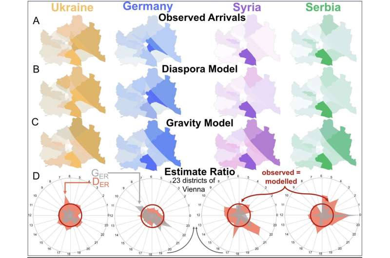
Vienna model results. A) Heat map of Vienna of the observed arrivals in Austria for the four top diasporas in Austria. B) Heat map of the diaspora model estimates in Vienna. C) Heat map of the gravity model estimates in Vienna. D) Spider plots of the top four diasporas in Austria, where each section is one of Vienna's 23 districts. The ratio between the modeled and the observed arrivals—the estimate ratio—is displayed for each district for both the gravity model in gray (GER) and the diaspora model in red (DER). The inner circle (dark red) is when the observed and the modeled arrivals are equal. When the polygons are smaller than the circle, the model underestimates the number of migrants but overestimates that number when it is bigger. Credit: Prieto-Curiel et al

How do migrants choose their destinations? Existing models, known as "gravity models," use population size and travel distance as explanatory variables—and often fail, especially at the neighborhood scale. Many migrants prefer to move to a location near friends, family, or co-nationals.

This pattern might be partly driven by factors that repeat (such as the cost of living) and partly driven by homophily, the tendency to interact with others who are similar. Early migrants tend to reduce uncertainty and provide information for later arrivals. Building on these observations, Rafael Prieto-Curiel and colleagues construct a migration model based on the power of the diaspora to shape migration flows.

In one study, published in PNAS Nexus, the authors explore arrivals to Austria from other parts of the world, estimating that 10,000 individuals of a given nationality will attract roughly 1,204 new arrivals from that same nationality to the same postcode each year.

A diaspora-based model of human migration
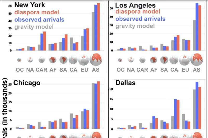
Results of the arrival flows of the top metropolitan areas in the US: New York, Los Angeles, Chicago, Dallas, Houston, and Miami. We plot the observed flows (blue), the diaspora model estimates (red), and the gravity model estimates (gray) for eight estimated diasporas: Oceania (OC), North America (NA), Caribbean Islands (CAR), Africa (AF), South America (SA), Central America (CA), Europe (EU) and Asia (AS). The diasporas are ranked according to their total arrival flow in the US in 2019. The smallest diaspora is from Oceania, with around 110,000 individuals, while the largest is from Asia, with more than 25 million migrants. Credit: Prieto-Curiel et al

In the United States, the model can predict arrivals from a given country to a given city from previous migration figures from that country to that city.

The model helps explain why people from South America are four times more likely to move to Miami than to Houston, despite the cities being roughly similar in size and roughly equidistant to both regions of origin. The diaspora model outperforms the  at the city and neighborhood scale and can be used to inform infrastructure planning and policy.

More information: Rafael Prieto-Curiel, The diaspora model for human migration, PNAS Nexus (2024). DOI: 10.1093/pnasnexus/pgae178academic.oup.com/pnasnexus/art … /3/5/pgae178/7674968


Journal information: PNAS Nexus 


Provided by PNAS Nexus

Estimating flows of forced migrants from war and crisis