It’s possible that I shall make an ass of myself. But in that case one can always get out of it with a little dialectic. I have, of course, so worded my proposition as to be right either way (K.Marx, Letter to F.Engels on the Indian Mutiny)
Tuesday, March 21, 2023
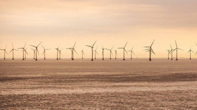
Lithuania Preps for its First Offshore Wind Auction
The Government of Lithuania has approved the requirements for developers wishing to participate in the upcoming auction for the construction of the Offshore Wind Park in the Baltic Sea. The National Energy Regulatory Council (VERT) is expected to open the tendering process on March 30 and the winner will be announced this summer.
According to the auction conditions, prospective bidding companies must have revenues of at least $266 million in the last three years and at least 20% of the project value in equity. Lithuania’s 700 MW Offshore Wind Park is estimated to cost over $1 billion to develop.
Further, bidders must have developed at least one offshore power plant larger than 150 MW or be authorized to produce electricity there. Developers will also be required to support local communities of the municipalities bordering the marine area of the offshore park, as well as contribute at least $5 million to environmental protection.
Once the construction is completed, the developer will be expected to make an annual contribution equivalent to about $1 per MWh of electricity generated to the communities surrounding the park. Considering the project will generate up to three terawatt-hours per year, the sum could reach $3 million annually.
Most importantly, the developer offering the highest development fee to the state stands the highest chance to win the tender.
The construction of Lithuania’s first offshore wind farm has been in the making since June 2020, when the government identified the farm’s location in the Baltic Sea. The site covers an area of 137.5 square kilometers, with a distance of approximately 29 kilometers off the coastal town of Palanga in western Lithuania. The project is expected to begin operation in 2028.
According to Lithuania’s National Energy Independence Strategy, the 700 MW Baltic Sea wind farm is a critical project aimed at boosting the country’s local electricity production from renewable energy sources. When operational, the project will meet up to a quarter of Lithuania’s electricity demand.
Uncrewed Ocean Mapping Vehicle Closing Gaps in Remote Waters
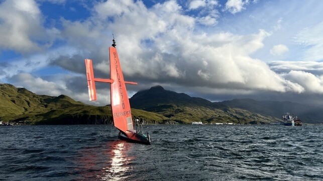
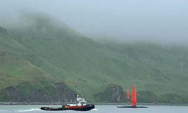
Saildrone Surveyor SD 1200 sails out of Dutch Harbor on Amaknak Island in Unalaska, AK.
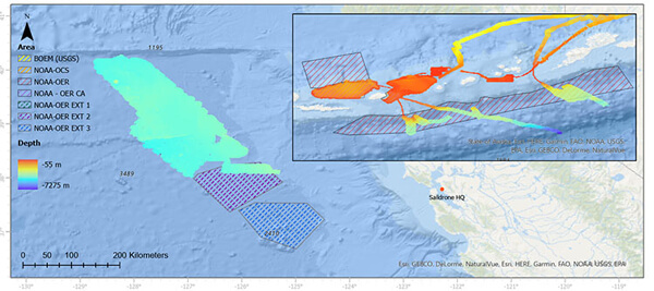
The Saildrone Surveyor, the world’s largest uncrewed ocean mapping vehicle, has mapped more than 45,000 square kilometers (17,375 square miles) of previously unexplored ocean floor during a months-long survey around Alaska’s Aleutian Islands and off the coast of California.
The Saildrone Surveyor, the world’s largest uncrewed ocean mapping vehicle, has completed a months-long survey around Alaska’s Aleutian Islands and off the coast of California as part of a multi-agency public-private partnership funded by the National Oceanic and Atmospheric Administration (NOAA) and the Bureau of Ocean Energy Management (BOEM) to address ocean exploration gaps in remote areas with uncrewed surface vehicles (USVs).
The United States Exclusive Economic Zone (EEZ), stretching from the coast to 200 nautical miles from shore, is one of the largest in the world, but it is largely still unmapped, unobserved, and unexplored. Alaska’s coastline is approximately one-third of the entire US coastline, far longer than that of any other US state or territory. And yet, Alaska is by far the least mapped region of the US EEZ.
In 2022, the White House released the Strategic Priorities Report for Ocean Exploration and Characterization report, which specifically calls out the Aleutian chain as one of the highest priority regions in the US EEZ for collecting additional data and information in multidisciplinary interests across the Federal space. Exploration and seafloor mapping of this region has the potential to unlock new opportunities for conservation, climate science, and the Blue Economy.
“Every American, in one way or another, depends on the ocean—from protein from fish to feed animals or humans, to deep-sea cables that make the internet possible. The only way the US can maximize our ocean resources is to understand what’s there. This mission is the first step to mapping the seafloor of key regions in Aleutian waters in high resolution. The beauty of the Surveyor is getting that initial exploration step done faster, cheaper, and without as much staff,” said Dr. Aurora Elmore, Cooperative Institute Manager at NOAA Ocean Exploration.
To the unknown and back
Saildrone Surveyor SD 1200 departed Saildrone HQ in Alameda, CA, to sail across the North Pacific to the survey area around the Aleutian Islands in July 2022.
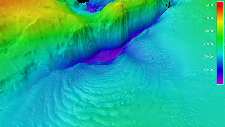
For 52 days between August and October, the Surveyor mapped 16,254 square kilometers (6,276 square mile) of unknown seafloor around the Aleutian Islands. Mission collaborators were able to follow the data collection in real time. Preliminary data revealed unprecedented detail of the Aleutian arc seafloor, including previously unknown structures, some of which indicate potential hydrothermal vents.
Amukta Canyon in the Bering Sea, as mapped by the Saildrone Surveyor during the Aleutians Uncrewed Ocean Exploration expedition.
Severe weather is the norm in the Aleutian region, with violent storms and persistent fog. During the mission, the Surveyor was diverted south to a secondary priority area to avoid the remnants of Typhoon Merbok that pounded Alaska with gale-force winds. “Part of the premise of the mission was to test the Surveyor to its limits,” said Rachel Medley, chief of the Expeditions and Exploration Division at NOAA Ocean Exploration and NOAA co-chair for the Interagency Working Group on Ocean Exploration and Characterization (IWG-OEC).
Despite 35-knot winds and wave swells over 5 meters (16 feet)—conditions that would have proved too challenging for most crewed survey vessels—the Surveyor continued to collect high-quality data without risk to human life and with a reduced carbon footprint.
In addition to high-resolution mapping sonars, the Surveyor carried technology from the Monterey Bay Aquarium Research Institute (MBARI) to sample environmental DNA (eDNA). Outfitted with the Environmental Sample Processor (ESP)—a groundbreaking “lab in a can”—the Surveyor was able to collect important clues about marine biodiversity and ocean health from the genetic “fingerprints” left behind by marine life that can inform our knowledge about marine biodiversity and ocean health.
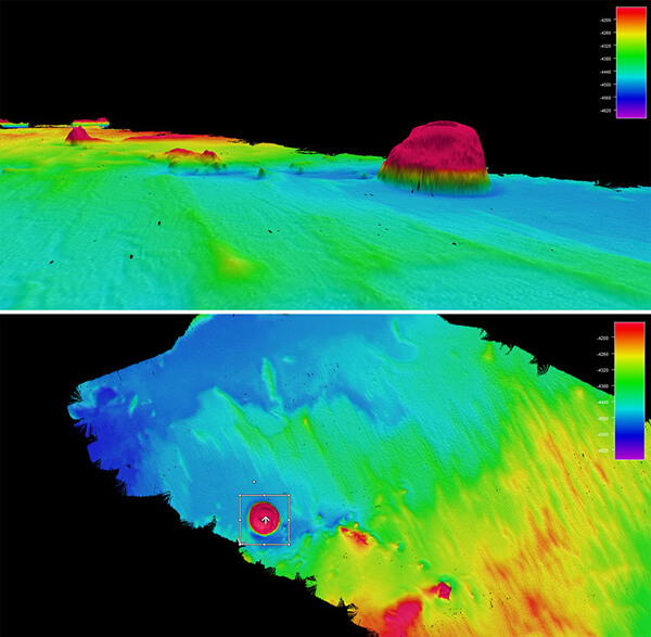
Top and side views of the 1,000 m seamount mapped by Surveyor SD 1200 using its Kongberg 304 echo sounder during the second part of the Aleutians Uncrewed Ocean Exploration expedition.
New discoveries—right off the coast of California
After transiting 2,000 nautical miles back to San Francisco and a brief pit stop at Saildrone HQ, the Surveyor was tasked to map additional priority areas a few hundred miles off the coast of California.
The Surveyor mapped an additional 29,720 square kilometers (8,665 square nautical miles) of the US EEZ and discovered a previously unknown seamount standing approximately 1,000 meters (3,200 feet) high from the seabed. Discoveries like this improve our understanding of the physical processes of the ocean and help scientists identify unique habitats that need further exploration.
The future of ocean mapping
Accurate and up-to-date topography of the ocean floor is essential for understanding how ocean currents move heat and carbon around the planet, sustainably managing resources, tsunami and storm surge forecasting, safety of navigation, telecommunications, developing and maintaining coastal infrastructure, and establishing new offshore energy sites. Oceans cover more than 70% of Earth’s surface, but as of June 2022, less than 24% of the global ocean has been mapped using modern technology, leaving most of the planet unmapped and unexplored.
This is because the traditional method of exploring and mapping the ocean with large survey ships is difficult, time-consuming, and expensive. The global Seabed 2030 initiative and the National Strategy for Mapping, Exploration, and Characterization (NOMEC) of the US EEZ have set ambitious seafloor mapping goals, which cannot be achieved with the current global survey fleet alone.
Rigorous sea trials showed that the data quality the Surveyor collects rivals that of the most advanced ocean survey ships in use today—meeting or exceeding International Hydrographic Organization standards.
The Saildrone Surveyor represents a paradigm shift in how we explore our oceans, carrying the same cutting-edge sonar equipment as survey ships to deliver high-resolution data to the global community—at a fraction of the cost and carbon footprint.
“Surveyor brings a new and exciting capability for ocean exploration and mapping. Mapping in the Aleutians is not trivial, and the conditions there can be austere any time of year. The Surveyor weathered the storms, collected high-resolution bathymetry, and put no humans at risk. This mission proves that long-endurance USVs provide a viable option to achieve the goals of NOMEC. This is the future of ocean mapping,” said Brian Connon, Saildrone VP of Ocean Mapping.
The Aleutians Uncrewed Ocean Exploration expedition served as an excellent example of how public-private partnerships and uncrewed surface vessels (USVs) like the Surveyor can increase the pace and efficiency of seafloor mapping and help us reach national and international goals. Whether used on their own or paired with traditional ship-based operations, USVs can act as force multipliers, expanding capabilities in a way that is cheaper, more environmentally friendly, and safer.
The total area mapped by Saildrone off around the Aleutian Islands and off the coast of California.
What happens to the data?
NOAA Ocean Exploration is already using some of the preliminary data collected by the Surveyor to inform its exploration of Alaskan waters with NOAA Ship Okeanos Explorer during its 2023 field season.
These expeditions, the first for the ship in the region, will fill gaps in the understanding of Alaskan deep waters through mapping and remotely operated vehicle operations. The ROV operations will establish baselines to help sustainably manage and protect Alaska’s deep waters and the resources they provide and contribute to safer navigation and community access, hazard mitigation, and a deeper comprehension of and appreciation for the region’s marine environment.
“NOAA Ocean Exploration is excited to see the results of this remarkable multi-partner expedition come to fruition,” said Jeremy Weirich, director of NOAA Ocean Exploration. “By joining forces with other federal agencies, academia, and industry, we were able to leverage a variety of expertise and multiple technologies to investigate areas off of Alaska and California that were otherwise unexplored. In order to map and characterize vast and remote expanses of the ocean, we need new technologies like the Saildrone Surveyor to augment ship-based exploration.”
Saildrone Surveyor SD 1200 is escorted out of Dutch Harbor in August 2022.
Once post-processing has been completed by the Center for Coastal and Ocean Mapping at the University of New Hampshire, the high-resolution data collected during the Aleutians Uncrewed Ocean Exploration expedition will be made publicly available through NOAA’s National Centers for Environmental Information to further exploration and characterization efforts and in support of US and international mapping initiatives, including the Seascape Alaska regional mapping campaign.
“This mission is an exciting partnership opportunity with industry, academia, and government to accelerate and advance new US-based technologies that will not only benefit the scientific community but also have the potential to answer some of our largest global challenges by providing a better understanding of ocean dynamics and climate science,” said Medley.
Scaling up the fleet
SD 1200 is the first of Saildrone’s Surveyor class vehicles. An additional four Surveyor-class ocean mapping vehicles will be built by Austal USA in Mobile, AL, this year to meet increasing global demand for uncrewed survey vehicles.
This article is courtesy of Saildrone. It can be found in its original format with additional links here.
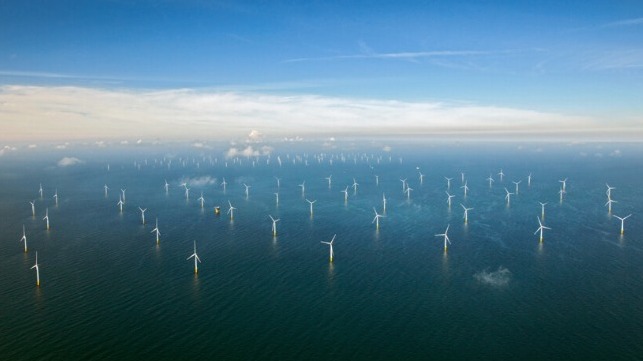
Netherlands Plans World’s Largest Offshore Hydrogen Production Site
Hydrogen production will take place offshore next to the Gemini wind farm (Gemini)
The Netherlands is moving forward with plans for the development of the world’s largest offshore hydrogen production project. Last December the government said it intended to pursue offshore hydrogen production and today the Ministry for Climate and Energy Policy announced the site selection working from existing plans for offshore wind farm development and the existing natural gas pipeline.
The project would be the first in which hydrogen production at sea is carried out on a large scale. The site selected is the Ten noorden van de Waddeneilanden Wind Farm Zone located 30 nautical miles off the north coast of the Netherlands in the North Sea. The government has been studying the site in its plans for additional offshore wind farm development. Plans had called for a wind farm tender in 2022 but were delayed while additional studies were taking place to finalize the route for the export cables from the site to shore.
The designated site consists of nearly 30,000 square acres and the government reports there is strong support within the Groningen region for the project. The wind farm plan calls for the development of a new farm located north of the Wadden Islands that would provide 700 MW of electric power from wind. The existing Gemini Wind Farm (600 MW) lies within the region adjacent to the designated site. Gemini began operations in 2017 as one of the world’s largest offshore wind parks, both in terms of size and production.
The ministry said the wind farm would provide 500 MW of electrolysis capacity. They expect it should be operational around 2031. The site was also selected because there is an existing natural gas pipeline that can possibly be reused for transport to land. They believe it could also be connected to the planned hydrogen network which will be developed by Gasunie.
“We are a global leader with this plan. It is also a big step on top of the goal of 4GW electrolysis in 2030 from the Climate Agreement,” said Minister Rob Jetten. “We have already designated the area as a preferred location so that preparations can start quickly and we provide the sector with clarity so that they can make their investment plans. The province and the municipalities are fully committed to a green economy in which the production of sustainable energy is central.”
The expectation is that the project can provide valuable experience with this new technology, which they expect will play a major role in the energy system of the future. It will also expand on the work underway on a smaller pilot with an electrolysis capacity of approximately 50-100 MW. This first project the government says should help to identify and address issues from the technology so that the project of 500 MW can be realized efficiently. Later this year, the minister also wants to choose a preferred location for this smaller project.
Before the tenders are issued, the Ministry is carefully working out several important matters together with the Groningen region, parties around the Wadden Sea Region, and involved parties. This includes discussions on the landing of the pipeline to bring the hydrogen from the wind farm ashore and how hydrogen production can be done safely and in an ecologically responsible manner.
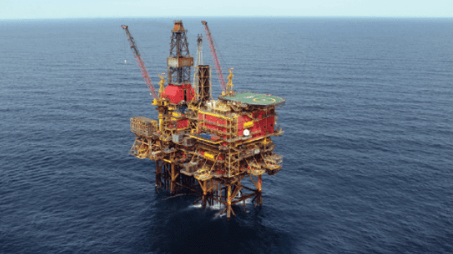
UK Union Says Strikes Will Cause Standstill at Dozens of Oil Platforms
Unite says 1,400 workers have voted for strikes over pay and work conditions (file photo)
Update: Unite announced it has reached terms with Sparrows Offshore for 50 workers employed on BP platforms. It is a portion of the workforce due to start short work stoppages next week on platforms also operated by Apache, Shell, and Harbour Energy. The agreement for the BP workers provides three additional weeks of paid leave, which Unite says equates to a 10 percent pay increase. Other terms include the implementation of 2022 pay increases and overtime pay for work beyond normal 12-hour shifts. Unite said the disputes against other portions of Sparrows and the other companies outlined in this article remain unresolved.
The UK offshore oil and gas industry is facing the prospects for additional strikes as Unite the union continues to target the sector with job actions over pay and working conditions. The union reported today that it has received strike mandates from a total of nearly 1,400 employees of five additional service companies supporting major operators including BP, Shell, Total, and others. Unite has been targeting the offshore energy sector after it reported record profits.
“Unite has received unprecedented support in favor of industrial action in the UK Continental Shelf. It is the biggest mandate we have received in a generation in the offshore sector,” said John Boland, industrial officer at Unite. “There is no doubt that this is directly linked to oil and gas companies reaping record profits while the workforce gets scraps from the table.”
The union is predicting that the disputes, which involve service companies Bilfinger UK, Stork, Petrofac Facilities Management, and Wood Group UK, could result in a “Tsunami of industrial action” at dozens of platforms. The prospective action would include electrical, production, and mechanical technicians in addition to deck crew, scaffolders crane operators, pipefitters, platers, and riggers.
Each of the companies’ contracts has come up for negotiation with the size of the workforce and the nature of the dispute varying by company. The largest involves approximately 700 offshore workers at Bilfinger UK which are involved in a pay dispute. A further 350 at Stork are disputing work schedules and pay rates. The other two disputes are smaller in scale with 50 workers at Petrofac Facilities Management working at the FOFI platform disputing holiday work rules. A further 80 workers at Wood Group on the TAGA platforms are seeking to win back a 10 percent pay cut the company made in 2015.
These latest strike authorizations come in addition to a current plan for up to 200 workers at Sparrows Offshore Services to begin 24, 48, and 72-hour work stoppages between the end of March and June over pay. Announced at the beginning of March, this involves crane operators, maintenance workers, and lifting personnel as well as deck crews on platforms run for BP, Shell, Apache, and Harbor Energy.
The latest strike effort could also be further expanded with two additional strike votes which are currently underway. Unite is conducting balloting for 80 workers at Petrofac BP and a further 50 workers at Worley Services UK. Combined with the current efforts, this could involve a total of 1,500 offshore workers in the various actions.
The union has been staging rolling actions across the industry over the past few months. In February, they reached an agreement for nearly 100 drillers working for Odfjell Technology. The drillers will receive three weeks of paid time off work per year, which Unite says equates to around an 11.5 percent wage increase.
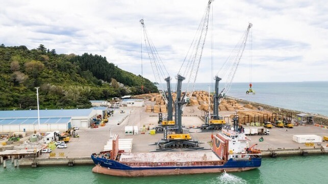
Port Handles First Containers in 40 Years in Cyclone Relief Effort
Rangitata alongside in Eastland Port moving her first containers (Drone images by Brennan Thomas, Strike Photography - Courtesy of Eastland Port)
It is not often that you hear a port say it is handling containers for the first time in 40 years. New Zealand’s Eastland Port on the North Island, however, is doing just that as part of a support effort to help the local communities in response to Cyclone Gabrielle which hit the region hard.
Located in Gisborne City, Eastland Port is New Zealand’s second-largest log export port handling three million tons of wood each year. The port, however, has not been serving coastal shipping for more than 40 years. This all changed today, March 21, when a chartered vessel, the Rangitata (1,650 dwt), docked for the first time to open the new vital link which the Regional Economic Development Minister Kiri Allan told the New Zealand Express will be a “blue highway.”
Tropical Cyclone Gabrielle formed in early February moving across the North Island of New Zealand leaving a path of destruction in its wake. Eleven people were killed and thousands displaced with reports indicating that the aftermath of the storm could cost NZD$13.5 billion (US$8.4 billion) in long-term repairs. At its peak, maximum winds exceeded 90 mph with massive amounts of rain and flooding before the storm moved on to impact both Vanuatu and Australia.
Remote communities and businesses on the North Island are suffering from the aftereffects. One of the main roads in the region is washed out with no definitive timeline for when it can be reopened. In response with farmers and other businesses struggling to move their goods, port and local government officials began lobbying for the blue highway to support the community in the aftermath of the storm.
The port’s chief operating officer Andrew Gaddum told the New Zealand Herald the effort would be “a game changer.” He cites the fact that freight routes have been severely disrupted with the few trucks that can travel required to take long, circuitous routes dramatically increasing the time and cost of moving their goods.
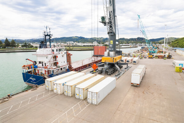
Containers are being moved via coastal shipping as part of the cyclone relief effort (Drone images by Brennan Thomas, Strike Photography - Courtesy of Eastland Port)
The Eastland Port is underwriting the effort investing approximately US$1.4 million including converting parts of the Gisborne log port to handle products ranging from meat to fruit and vegetables. Cranes had to be repurposed from moving logs to handle the containers, generators had to be supplied for the refer boxes, and operators had to be trained. Gaddum said it has been “a monumental learning curve,” but thanked everyone’s effort and support including the Napier Port which will be the other terminus for the blue highway. The government provided a grant of just over US$300,000.
The 16-year-old general cargo ship Rangitata has been chartered for three months. The 220-foot vessel which is registered in New Zealand is able to transport containers, including refers, which will be perfect for the farmers to move the local meat and produce to market.
“The Rangitata made history yesterday being the first container ship we’ve seen at Eastland Port in decades,” reports port executives after the vessel’s arrival. “It’s great to see the return of containers to our port and we are excited to be doing our bit for the region in terms of shoring up our resilience.”
The vessel brought in an initial shipment of thirteen 40-foot empty containers and loaded thirteen 40-foot full containers with meat and fresh produce. She departed late on March 21 heading to Napier and will return later in the week with 17 more containers.
While it is the first time in many years that commerce has traveled by coastal shipping, port officials hope it might continue beyond the immediate relief efforts. They are already speaking with local businesses to gauge interest in maintaining the service highlighting that they believe it can be cost-competitive and good for the environment by removing diesel trucks from the roads.
Ukrainian Mariners Rescue Russian Sailing Vessel in the Pacific
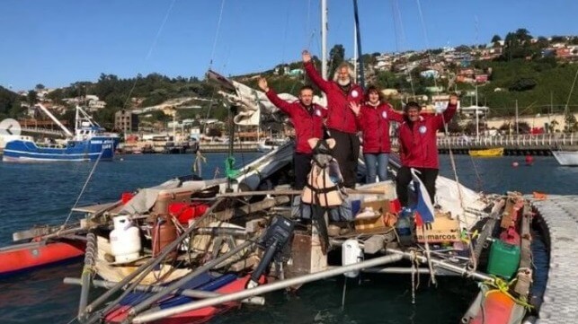
Crew of the Russian Ocean Way before their departure from Chile (Russian Ocean Way)
A Ukrainian-crewed bulker has rescued a disabled Russian sailing vessel on the high seas of the Pacific, the sailboat's skipper told U.S.-funded Russian news outlet Sibir Realii.
The inflatable trimaran sailboatRussian Ocean Way has been sailing around the world since mid-2021, and it has completed about 13,000 nm of its planned 32,000 nm route over the past two years. At the end of February, the boat set out for a Pacific crossing from the port of Talcahuano, Chile, bound for Easter Island. It was under way about 1,000 miles to the west of Chile when it got hit by a storm, and the wind and waves damaged the vessel's steering. A steering box was bent and broken from the strain, according to skipper Stanislav Berezkin, and its attachment mount began to crack.
Unable to make further repairs and certain that the cracking would worsen, the all-Russian crew put out a distress call, and Chile's rescue coordination center found a nearby bulker willing to come to their aid. The vessel was the Panama-flagged Sounion, operated by Laskaridis and crewed by Ukrainian and Filipino seafarers.
In heavy swells, the bulker created a lee and came alongside the trimaran so that the crew could lower a pilot ladder and bring aboard the three sailors. All were safely transferred, along with their belongings, and the captain of the Sounion even offered to tow the catamaran on the voyage back to Chile.
Communication was simple, since the bulker's captain was Ukrainian and spoke Russian - but some areas of discussion were best avoided, according to Berezkin.
"[The captain] said that he was from Mariupol, and from the bombing, he had to leave for Kyiv. We don't ask anyone else about anything. This is a bad topic," said Berezkin.
Op-Ed: Befriending Stowaways Puts Seafarers at Risk
As the container barge Brooklyn Bridge arrived in San Juan on a routine voyage from Jacksonville last week, 16 migrants jumped over the side and attempted to swim to shore. They were in possession of life jackets, and they were rescued from the water by a patrol boat from U.S. Coast Guard Sector San Juan. This is just another recent example of stowaway activity, and unfortunately not all incidents are safely resolved.
Stowaways often have tragic stories to tell about their past and what has led them to take the risk of illegally boarding a vessel. However, their desperate circumstances can lead to unpredictable actions, and seafarers should beware. The best thing for the Master to do is notify the office immediately on discovering stowaways and for crews to resist befriending them.
Otherwise, stowaways can create safety issues and legal problems for crews. A case study involving seven male stowaways found aboard a bulk carrier after it had left Kenya should serve as a warning to all shipping companies and their crewmembers. The stowaways were treated in accordance with IMO guidelines, but the situation became problematic once they struck up friendships with the seafarers. The mariners agreed to help them disembark the vessel at another port, while the Master failed to report to the shipowner that he had stowaways on board.
On learning that their final destination was in South America, the stowaways planned to leave the ship in Durban and board another vessel heading elsewhere. In Durban, the crew gave the stowaways clothes and money, before rigging a rope on the seaward side of the vessel to enable the illegal passengers to enter the water without being spotted from ashore.
The seven stowaways planned to swim to the opposite side of the shore, but two tragically drowned as they were not strong swimmers. The remaining men reached safety and handed themselves into the authorities. They then accused the crew of forcing them off the vessel and into the harbor, leading to the arrests of the ship’s Master and three crewmembers who were all charged with murder.
The local authorities rightly took the claims seriously, as this type of crime is not without precedent. An American tugboat captain forced three Jamaican stowaways to jump into shark-infested waters after finding them on his ship in 1993. The stowaways were never found.
In the current case, though, the accusations was unfounded, and the charges the crewmembers faced were later reduced to manslaughter after it became clear the stowaways had embellished their story. However, the Master and three seafarers had clearly breached immigration law. They were eventually found guilty of assisting the stowaways and smuggling them ashore, which saw them receive suspended prison sentences and fines.
In another case, UK special forces stormed a tanker after reports of a stowaway hijacking. Charges against the stowaways were ultimately dropped due to lack of evidence that the crew were threatened or that the stowaways intended to take control of the ship. The situation was, however, tense, and therefore dangerous.
So, while friendly conversation with stowaways may seem normal and harmless, seafarers can easily fall into the trap of making bad judgement calls that leave them in danger or open to prosecution.
Crewmembers who allow men or women they have befriended in foreign ports to stow away on board may also face prosecution. Violating immigration laws is one risk; another is that the stowaways accuse seafarers of impropriety or more serious offenses if caught by the authorities.
Around 1,000 stowaways are discovered each year. Cape Town, Durban and Lagos are boarding hotspots, with Bilbao in Spain popular with stowaways trying to reach the UK.
Advice for dealing with stowaways is available from the IMO’s Resolution A.871(20) Guidelines on the Allocation of Responsibilities to Seek the Successful Resolution of Stowaway Cases. Additional guidance on how to treat stowaways can be found in Section 4C of the Facilitation of International Maritime Traffic Convention. However, neither cover the risks of befriending stowaways.
Our general advice to members is to follow the IMO guidelines and instruct crewmembers to refrain from socializing with stowaways or granting them special favors. Additionally, the Master should notify the office immediately and provide as many details as possible if a stowaway is discovered onboard. Those details should then be forwarded to the company’s insurer at the first opportunity to expedite the repatriation process. This could involve returning to the stowaway’s country of origin, if this can be determined, or to proceed to a scheduled destination port. Either way, it is likely to be costly for the shipowner. Best not to add to those costs by putting crew and stowaways at further risk through misguided friendships.
Useful resources for additional information on stowaways include the Nautical Institute’s ‘Stowaways by Sea and Rescue of Migrants’. West P&I members can also get in contact with the club should they have any follow-up questions on stowaway incidents.
Simon Hodgkinson is Head of Loss Prevention at West P&I.
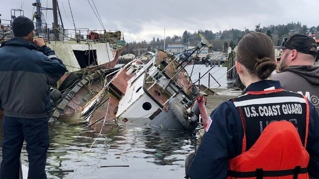
Derelict Tug Goes Down Suddenly on Seattle's Ship Canal
An abandoned tug sank suddenly at a wharf in Ballard, Seattle on Monday, coming to rest with its funnel on the pier.
The Seattle Fire Department and the U.S. Coast Guard responded to the scene at about 1045 hours on Monday morning. They found a derelict tug taking on water. The vessel was empty and unoccupied, so no rescue response was required, and the tug went down fast as the crew stood by.
Two other abandoned vessels were tied off to the tug when it went down, but they were not affected, the Coast Guard said.
The lost tug had been defueled two years ago when officials made the determination that it was an abandoned vessel. The Coast Guard confirmed that there were no pollutants on board, though a light sheen was visible around the wreck site. The incident was out of the channel and had no impact on marine traffic.
Derelict vessels are a costly problem for local and national authorities. Remediating pollutants, arranging for disposal and (if necessary) refloating sunken hulks are all costly measures, and are all too often left to public agencies. If left untended, they can release pollutants or go adrift, posing a hazad to other vessels. Last month, salvors raised a WWII-era tug that had partially sunk in the port of Juneau's Gastineau Channel, the second nuisance vessel to cause problems on the waterway in three years.
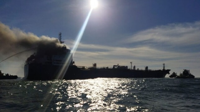
Product Tanker Burning off Portuguese Coast
Prodcut tanker caught fire less than two miles from the coast of Portugal as it was heading into port (Marinha Portuguesa)
Portuguese authorities are working to control a fire aboard a product tanker off the coast while they are also hoping to tow the ship further out to sea. So far, the fire is believed contained in the aft end of the vessel not reaching its cargo of jet fuel and diesel and there has not been an oil leak. However, the fire is continuing to burn with spectators along the shoreline posting photos of the burning ship which is less than two miles from the coast.
The tanker Greta K (24,768 dwt) was inbound for the port of Leixões, having already boarded her pilot when the fire was reported around 3:30 p.m. Marinha Portuguesa is monitoring the situation reporting that Port Authority was able to quickly send three tugboats to the vessel. In addition, the Port Captain for Douro and Leixões sent two additional tugboats to assist.
They have evacuated 12 of the 19 Filipino crewmembers aboard the vessel. The other seven have remained aboard to assist in the firefight. Local media is reporting that the fire was contained at the stern and suspected to have started in the engine room. Black smoke is seen billowing from the stern.
The fireboats are spraying water on the aft sections of the ship while others were assigned to cool the tops of the cargo tanks. The teams are concerned that there could be a secondary ignition and trying to prevent the fire from reaching the cargo. There is no crude aboard, but they have not yet reported how much fuel the vessel is carrying or the volume of cargo aboard.
The Greta K is registered in Malta. The vessel is seven years old, built in 2016. Equasis lists the owners as San Giorgio Del Porto of Genoa and the managers as K-Ships, also of Genoa.
The product tanker is being used to shuttle fuel supplies from neighboring Sines to Leixões. According to the reports, the local refinery closed leaving the region dependent on tankers for their fuel supply.
Emergency teams are also standing by and prepared with pollution response equipment. Marinha Portuguesa is assisting in calculating the drift, in part to prepare in case of an oil leak from the vessel, as well as calculating the movements of the vessel. This evening it was reported that they were putting a tow line on the burning vessel in an effort to move it further out to sea.
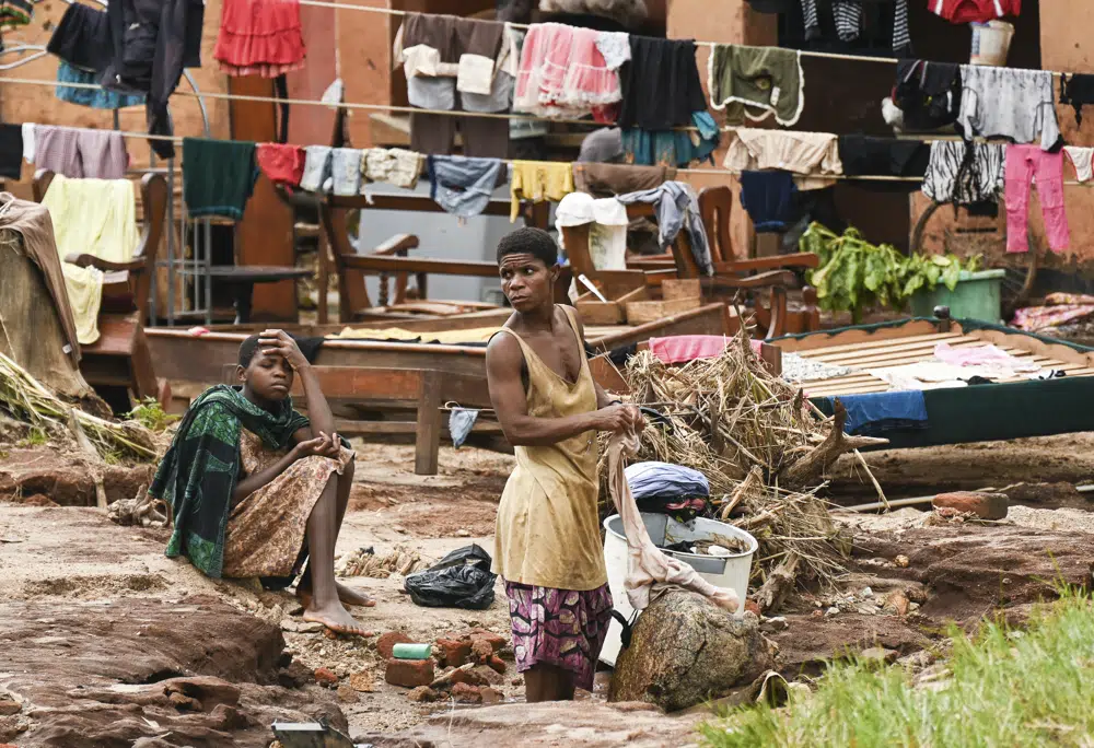
A week on, brutal Cyclone Freddy still taxes southern Africa
By WANJOHI KABUKURU
March 20, 2023 1 of 6 Clothes are hung out to dry on called electrical power lines caused by last week's heavy rains caused by Tropical Cyclone Freddy in Phalombe, southern Malawi Saturday, March 18, 2023. Authorities are still getting to grips with destruction in Malawi and Mozambique with over 370 people confirmed dead and several hundreds still displaced or missing. (AP Photo/Thoko Chikondi)
In Malawi the death toll has reached 447 people, with 282 others missing and close to 400,000 people still displaced, authorities in the country said. Malawi’s southern region, including the financial capital of Blantyre, was the worst affected. In Mozambique, some 66 people have died and 59,000 are still displaced, according to local authorities.
Many people, including children “are traumatized by the cyclone,” said Palal Areman, from the aid agency Save the Children and based in Blantyre. “They were brought to the hospital with head injuries, broken limbs, and bruises, while others looked worried or had no family members.”
The United Nations emergency fund released $5.5 million to Malawi to assist communities affected by Cyclone Freddy on Monday.
A person pushes a bicycle past damaged structures caused by last week's heavy rains caused by Tropical Cyclone Freddy in Phalombe, southern Malawi Saturday, March 18, 2023. (AP Photo/Thoko Chikondi)
Flooding in the Shire River valley in southern Malawi remains a major impediment to search and rescue efforts, aid agencies said. The World Food Program said Monday 1,500 people had been rescued by boats in Malawi’s flooded river valley.
“The destruction and suffering that I witnessed in southern Malawi is the human face of the global climate crisis,” said United Nations Resident Coordinator for Malawi, Rebecca Adda-Dontoh. “The people I met with — many of whom have lost their homes and loved ones — have done nothing to cause this crisis.”
Both Malawi and Mozambique were dealing with a cholera outbreak when Freddy hit, heightening fears that the cyclone will worsen the situation in nations where health and relief workers were already stretched thin.
Cyclone Freddy is on course to be the longest-ever cyclone in recorded history, with an expert panel convening to decide if the cyclone has overtaken the current record holder, 31-day Hurricane John in 1994.
___
Associated Press climate and environmental coverage receives support from several private foundations. See more about AP’s climate initiative here. The AP is solely responsible for all content.