Wednesday, January 17, 2024

Iceland eruption confirms faultline has reawakened: expert


AFP
Tue, January 16, 2024

A volcanic eruption that has engulfed homes in an Icelandic fishing port confirms that a long-dormant faultline running under the country has woken up, threatening to belch out lava with little warning for years to come, an expert warned on Tuesday.

Glowing lava swallowed several homes on Sunday at the edge of the town of Grindavik, southwest of the capital Reykjavik.

The fishing town was mostly evacuated due to threat of an eruption last month and the most recent volcanic activity has since eased, authorities in the North Atlantic nation said on Monday.

The island straddles the Mid-Atlantic Ridge, a crack in the ocean floor separating the Eurasian and North American tectonic plates.

Sunday's eruption was the fifth in fewer than three years on the Reykjanes peninsula, which had not previously seen one in centuries.

"After eight centuries of a relative break and a complete cessation of surface activity, we have entered a new episode of plate separation which could last several years -- possibly decades," volcanologist Patrick Allard from France's Institut de Physique du Globe de Paris told AFP.

Even before the first of the five eruptions on March 2021, scientists "saw the ground distorting, with magma rising from the depths and seeping into" an area three to 10 kilometres (two to six miles) below the surface, he said.

As that magma bubbled its way upwards through fissures in the Earth, eruptions started to occur.

- 'Ready to erupt' -

The two most recent eruptions -- last month and on Sunday, both threatening Grindavik -- were brief and preceded by very little seismic activity.

This shows that the "magma is very close to the surface, ready to erupt", Allard said.

The thinness of the Earth's crust near the faultline under Iceland will help prompt these magma "pressure releases," he said.

But the amount that will actually burst out of the Earth's surface is not expected to be enormous, he added.

The location of this fragile faultline is likely to continue to be a problem.

It poses a threat to the nearby Svartsengi geothermal plant, which provides electricity and water to the 30,000 residents of the Reykjanes peninsula -- a tenth of Iceland's population.

The eruptions have also forced the closure of the Blue Lagoon, a popular tourist destination near Grindavik famed for its geothermal spas.

Allard said Grindavik was built on lava flows from 800 years ago, which "raises the question as to (the logic behind) the town's very existence".

And there will probably be little warning before the next eruption.

During the last two eruptions, there were only a "few hours of critical seismic activity" to warn that magma was quickly rising to the surface, he said.

There was also a risk of an underwater eruption, which could create an "explosive phenomenon, releasing more volcanic ash".

It was the huge amount of ash blasted into the atmosphere by the Eyjafjallajokull volcano in 2010 that caused global travel chaos, forcing the cancellation of some 100,000 flights and leaving more than 10 million travellers stranded.

However experts have said that such an extreme event is considered unlikely to happen on the Reykjanes peninsula.

Alligators get more intimidating after study reveals they have an amazing ability

Mark Price
Wed, January 17, 2024 


Alligators are full of surprises, but a closer inspection of their heads has revealed the predators have been hiding what amounts to an Aquaman-style superpower.

“New research shows that alligators ... can hear underwater,” the University of Georgia’s Coastal Ecology Lab reported in a Jan. 15 Facebook post highlighting the study.

“The alligator can tune their hearing to land or water by adjusting how tight the tympanic membrane is stretched. Moreover, they believe that this is part of an alligator’s submergence reflex and that it occurs automatically when an alligator goes underwater.”

This is not to say American alligators hear as well underwater as they do on land, researchers with Kirksville College of Osteopathic Medicine in Missouri concluded.

It just means they “hear better underwater than other animals,” the Coastal Ecology Lab reported.

This is in addition to being able to see underwater, due to a second set of eyelids that “act as underwater goggles,” experts say.

The newly discovered hearing ability makes perfect sense for an aquatic reptile known to hunt its prey “on land, at the water surface, and underwater,” the report notes.

Kirksville College scientists came to their conclusions after dissecting the ears of nine euthanized alligators “to see how the muscles of the ears worked.”

The test subjects, both juveniles and adults, were ”purchased commercially or obtained through the courtesy of the Louisiana Department of Wildlife and Fisheries.” The biggest was 9 feet, 9 inches long, the report states.

Details of the team’s discoveries were published by the American Association for Anatomy in an article titled “The anatomical basis of amphibious hearing in the American alligator.”

Much about the alligator ear is unusual, the study noted, including the fact they are located under flaps and the eardrum is “positioned deep from the surface of the skull.”


New Polling Shows How Much Global Support Israel Has Lost

Anna Gordon
Wed, January 17, 2024 

An activist shouts into a megaphone as hundreds of thousands of people join a protest in London on Jan. 13, 2024. Activists in London have joined a global mobilization campaign calling for an immediate ceasefire in Gaza. Credit - Guy Smallman–Getty Images

New data shared with TIME from the business intelligence company Morning Consult shows that support for Israel around the world has dropped significantly since the war in Gaza began.

Net favorability—the percentage of people viewing Israel positively after subtracting the percentage viewing it negatively—dropped globally by an average of 18.5 percentage points between September and December, decreasing in 42 out of the 43 countries polled.


China, South Africa, Brazil, and several other countries in Latin America all went from viewing Israel positively to negatively. And many rich countries that already had net negative views of Israel—including Japan, South Korea, and the U.K.—saw steep declines. Net favorability in Japan went from -39.9 to -62.0; in South Korea from-5.5 to -47.8; and in the U.K. from -17.1 to -29.8.

“The data shows just how tough of a road Israel has right now in the international community,” says Sonnet Frisbie, deputy head of political intelligence at Morning Consult.

The war began on Oct. 7, when Hamas massacred some 1,200 Israelis and took 240 hostage. Israel's retaliation has resulted in the reported deaths of at least 24,000 Palestinians, most of them women and children. Last week, the International Criminal Court took up South Africa's case charging Israel with committing “genocidal acts” in Gaza.

Read More: The Families of Israelis Held Hostage by Hamas Speak Out

Because Morning Consult conducts opt-in online surveys every day, analysts were able to see how public opinion in various countries shifted in the aftermath of the Oct. 7 attacks. Their surveys are conducted in 43 different countries on all six continents and used to anticipate market trends for their clients. The sample size of the survey varies in different countries, ranging from 300 to 6,000 responses over the course of a month.

The U.S. remains the only rich country that still had net positive views of Israel. Net favorability dropped just 2.2 percentage points, from a net favorability of 18.2 to a net favorability of 16 from September to December.

Washington's support for Israel carries a cost in global public opinion, however, particularly in Arab countries, the surveys show. In Egypt, the U.S. went from having a positive favorability of 41.1 to a negative favorability of -14.9 from September to December. In Saudi Arabia, the U.S. saw a similar trend, dropping from a positive favorability of 12.2 to -10.5 over the same time period.


Frisbie says that the shift will make it difficult for Saudi Arabia to continue cooperating with Israel and pursuing a planned normalization deal brokered by the U.S.

“A lot of cooperation between Gulf leaders and Israel has been done with Gulf leaders carefully messaging to their domestic populations and tiptoeing around public opinion. I think this gives this a lot less space to do that,” Frisbie says.

'Ending Israel's Gaza operation is also the surest way to avoid a regional war'

Harold Maass, The Week US
Wed, January 17, 2024 

President Joe Biden (L) listens to Israel's Prime Minister Benjamin Netanyahu as he joins a meeting of the Israeli war cabinet in Tel Aviv on October 18, 2023.

'The United States can and should distance itself from the Gaza debacle and the extremism of Israel's leaders'

Daniel Levy in The New York Times

The Biden administration should "distance itself" from Israel's "callous" Gaza military campaign, says Daniel Levy in The New York Times. Washington pledged "early and unwavering support to Israel following Hamas' Oct. 7 attacks." That has let Prime Minister Benjamin Netanyahu "slow-walk" Washington's requests for restraint to protect Palestinian civilians, hampering U.S. efforts to prevent a broader war. It's time to use America's "very real diplomatic and military leverage," starting with embracing calls for a cease-fire.

Read more
ARCHAEOLOGY
Rare 700-year-old piece of armor unearthed near castle in Switzerland, photos show

Moira Ritter
Wed, January 17, 2024 


Archaeologists exploring the area near a hilltop castle in Switzerland found pieces of burned-down walls and charred framing — and discovered the ruins of a medieval cellar.

Within the cellar, experts found evidence of a weaving center and an array of metal objects indicating the existence of a forge. As they looked closer, the team spotted something else: a nearly fully preserved iron gauntlet.

The piece of armor is an exceptional discovery dating back about 700 years to the 14th century, according to a Jan. 16 news release from the Canton of Zürich.

Archaeologists have previously discovered similar artifacts, but most are from no later than the 15th century, officials said. Although five other gauntlets from earlier have been found, none are in near as good condition as the newly discovered armor.

The right hand four-fold finger glove is made of iron plates placed on top of one another, similar to scales, and connected with rivets, experts said. The pieces of the glove were then attached to the textile or leather inside with more rivets.

The armor offered its wearer a great range of movement and flexibility, likely so they could hold a sword while wearing the glove, Lorena Burkhardt, a project manager on the archaeology team, said in a Jan. 16 Facebook video shared by officials.

Inside the cellar, archaeologists also unearthed a trove of ancient metal objects, including a mold, hammer and tweezers, according to Burkhardt. The cellar was likely used as a weaving center where metal objects were forged.

Fragments of the corresponding left hand gauntlet were also discovered, archaeologists said.

Experts found the cellar near Kyburg Castle, which is about 15 miles northeast of Zürich.

The first mention of Kyburg Castle was in 1079, and its name means refuge castle, according to its website. Since 1865, the castle has functioned as a museum.

Part of Hadrian's 1,800-year-old aqueduct and rare Greek coins unearthed near Corinth

Tom Metcalfe
Tue, January 16, 2024


The remains of rare silver coins that were part of religious worship in an ancient Greek settlement.

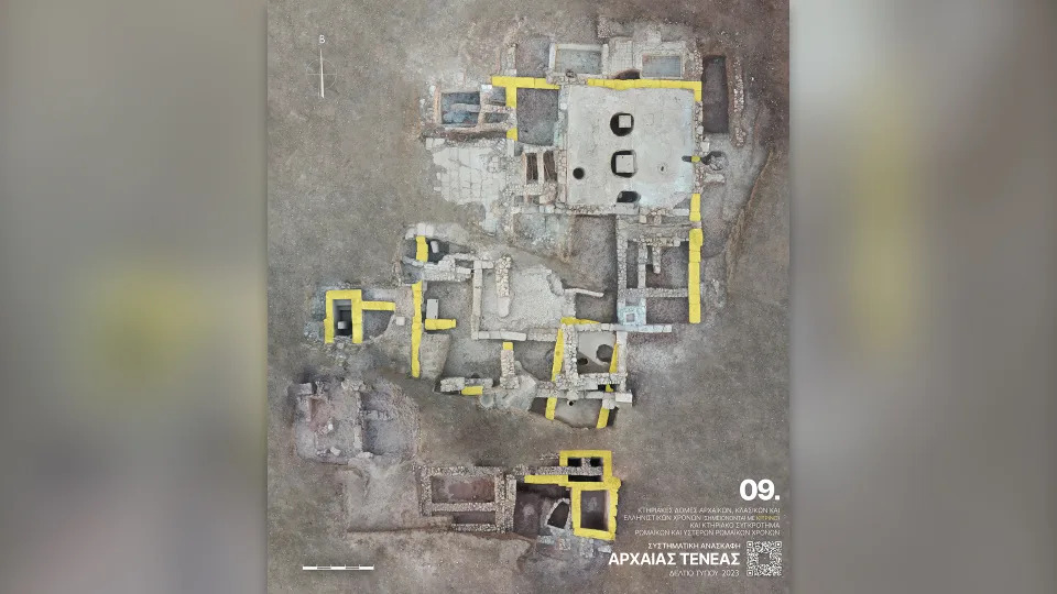
Archaeologists in Greece have unearthed part of one of the largest hydraulic projects from the ancient world: an aqueduct that the Roman emperor Hadrian built to supply water to the city of Corinth.

The remnants of the aqueduct were discovered in October during excavations at the archaeological site of Tenea, an ancient Greek town a few miles south of Corinth, according to a translated statement from the Greek Ministry of Culture and Sports.

Hadrian, who ruled the Roman Empire from A.D. 117 to 138, ordered the aqueduct built to carry water for more than 50 miles (80 kilometers), from Lake Stymphalia in the hills to the west of the city.

Aqueducts were already known in Greece, and Hadrian also had one built to supply water to Athens. But his aqueduct to Corinth is mentioned as a monumental work by ancient writers.

The rediscovered section is just over 100 feet (30 meters) long and runs from north to south alongside a river. It consists of a channel covered by a semicircular roof, both made of stone and mortar.

Related: Vast subterranean aqueduct in Naples once 'served elite Roman villas'

The exterior walls are more than 10 feet (3.2 m) high, and the interior space where the water flowed is about 2 feet (60 centimeters) wide and 4 feet (1.2 m) high.

Rare coins


A team excavating near the aqueduct also found tombs from the Greek

Image 3 of 3

Structures were also built at the site in the Roman period after the first century BC, Including furnaces and a press for olive oil.

Corinth was one of the great cities of ancient Greece. It is about 40 miles (70 km) west of Athens, on the far side of the great isthmus that connects the Peloponnese Peninsula to the rest of Greece.

The archaeologists also announced the discovery of a building complex in Tenea dating to the late Archaic period (roughly the eighth to fifth centuries B.C.) until the Hellenistic period (roughly the second and first centuries B.C.) that included places of worship for Greek heroes or gods.

Image 1 of 3

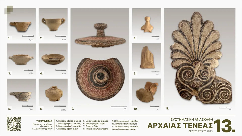
The archaeologists found pieces of pottery from the Archaic and Hellenic period of the site's occupation, roughly between the 8th century and the first century B.C.

Image 2 of 3

The also found ornately decorated

Image 3 of 3

Pottery objects were also found in the tombs from the Archaic period, including small flasks and parts of metal compasses for drawing circles (shown in the upper center).

They also found 29 rare silver coins alongside a portable clay altar, as well as a miniature vase and a figurine of a horse and rider. The coins date to the late sixth century B.C. and include some of the rarest ancient Greek coins ever found, including three silver staters minted at Olympia during different ancient Olympic Games, which was then a religious festival celebrated every four years.

The coins were linked to the religious use of the site, evidence of which — including female and animal figurines — was found during excavations in 2022, according to the statement.

RELATED STORIES

2,700-year-old temple with altar overflowing with jewel-studded offerings unearthed on Greek island

2,800-year-old figurines unearthed at Greek temple may be offerings to Poseidon

Hidden colors and intricate patterns discovered on the 2,500-year-old Parthenon Marbles from ancient Greece

The latest excavations have also uncovered structures built during the early period of Roman rule, after the first century B.C., including furnaces and an olive press, a Roman-era cemetery with elaborate stone tombs, and the remains of a prehistoric settlement thought to be from the Bronze Age, roughly 2600 to 2300 B.C. — long before the legendary fall of Troy, which is supposed to have happened around the 12th century B.C.

Artifacts from this earliest settlement included obsidian tools, animal figurines and large amounts of fine pottery. Much of the pottery was imported from the Greek areas of Aegina, Attica, Argolida and Corinth, showing the trading contacts the settlement had established with these areas, the statement said.


Ancient Roman necropolis holding more than 60 skeletons and luxury goods discovered in central Italy

Kristina Killgrove
Wed, January 17, 2024 

Gold necklace in situ around a partially excavated skeleton.


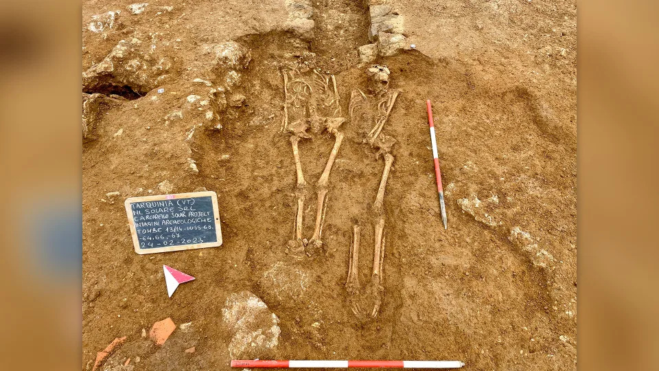
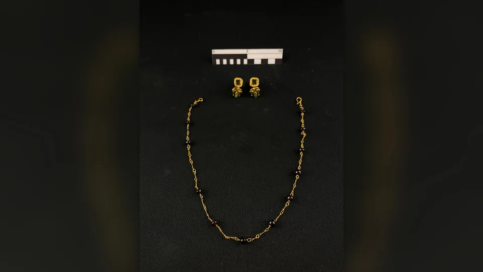
A Roman-era necropolis that likely holds the remains of the upper crust has been discovered in central Italy, and it contains nearly 60 graves replete with gold jewelry and the remains of leather footwear, pottery and other precious goods.

The cemetery, found ahead of construction work for a solar energy project in the town of Tuscania, may have been associated with a hotel-like villa that served as a way station for important travelers, such as provincial officials.

"The jewels, but also the glass, pottery, the footwear, the numerous coins, give us an image of people who enjoyed a certain well-being and could afford some small luxuries," Emanuele Giannini of the archaeology firm Eos Arc and the lead archaeologist at the site, told Live Science in an email.

Excavation of the necropolis.

Most of the tombs were in the so-called "cappuccina" style — a common burial type in which the deceased were covered with stone or ceramic tiles arranged in an A-frame shape. However, the archaeologists also found simple graves with no such covering, as well as skeletons contained in large ceramic vessels and evidence of some cremations.

Related: Elite Roman man buried with sword may have been 'restrained' in death

Burial of two people.

Dated to the height of the Roman Empire, to between the second and fourth centuries A.D., the necropolis was likely associated with a way station called a "mansio." There, dignitaries and other officials could stop for rest and refreshments while on government business. Giannini said that historical sources mention a mansio called Tabellaria along the via Aurelia, an ancient road which ran roughly from Pisa to Rome; the location of this mansio is just 1,640 feet (500 meters) from the cemetery, suggesting a connection.

Image 1 of 2

Tomb containing a person and a ceramic pot.

Image 2 of 2

Cappuccina style tomb.

So far, archaeologists have made only basic assessments of the newfound skeletons in terms of sex and age-at-death, and they suggest that the people lived in an urban context. "Discovering who they were is part of my research," Giannini said.

Image 1 of 2

Gold earrings after conservation.

Image 2 of 2

Gold necklace and earrings after conservation.

He and his team plan to undertake genetic studies to learn more about the 67 people who were buried in the necropolis, including trying to figure out whether the tombs that contained more than one person held the remains of family members.

RELATED STORIES

Roman-era tomb scattered with magical 'dead nails' and sealed off to shield the living from the 'restless dead'

'Completely unique' Roman mausoleum discovered in rubble of London building site

Dozens of decapitated skeletons uncovered at ancient Roman site in England

In addition, the artifacts found in the excavation are being studied and restored, Giannini said, and when that is complete, they will be exhibited in a local museum. "We have already done a lot, but much still remains to be done," he said.

Using the latest technology, Giannini and his team hope to extend their research by reconstructing the lives of the ancient population of the area in as detailed a manner as possible. The project is "ambitious but realistic," according to Giannini, but key to better understanding how people lived during the time of the Roman Empire.
Massive tectonic collision causing Himalayas to grow may also be splitting Tibet apart

Stephanie Pappas
Tue, January 16, 2024 

Photo from a 4 week tour through Tibet, its fascinating history and beautiful himalayan landscape.


Tibet may be tearing in two beneath the rising Himalayas, with pieces of the continental plate peeling off like the lid off a tin of fish, researchers have discovered.

According to new research presented at the annual meeting of the American Geophysical Union and posted as a pre-peer-reviewed pre-print online, this shows that the geology beneath the world's highest mountain range may be even more complex than previously believed.

The Himalayas are growing because two continental tectonic plates, the Indian and Eurasian plates, are colliding beneath the colossal mountain range. In cases where oceanic and continental plates collide, the denser oceanic plate slides beneath the lighter continental plate in a process called subduction. When two similarly dense continental plates collide, however — as is the case below the Himalayas — it's not so simple to predict which plate will end up under the other, and geoscientists are still unsure exactly what's going on in Tibet.

Some suggest that the bulk of the Indian plate may simply be sliding under the Eurasian plate without diving deeply into the mantle, a process called underplating; others believe that perhaps deeper parts of the Indian plate are subducting, while the upper parts are wedging themselves stubbornly against the bulk of Tibet.

Related: Fountains of diamonds that erupt from Earth's center are revealing the lost history of supercontinents

The new research suggests that the answer could be both these explanations. The researchers found evidence that the Indian plate is subducting, but it's warping and tearing as it does so, with the upper half delaminating, or peeling away.

"We didn't know continents could behave this way, and that is, for solid earth science, pretty fundamental," Douwe van Hinsbergen, a geodynamicist at Utrecht University in the Netherlands, who was not involved in the work, told Science Magazine.

To get a clearer picture of what's happening below Tibet, the  researchers investigated earthquake waves traveling through the crust at the region where the two plates collide. They reconstructed images from these waves showing what appear to be tears in the slab of the Indian plate's crust. In places, the bottom of the Indian plate is 124 miles (200 kilometers) deep, Science Magazine reported. In others, it is only 62 miles (100 km) to the bottom of the plate, suggesting some of it has peeled away.

RELATED CONTENT

— A single massive tectonic collision? That's not how the Himalayas came to be, scientists say

— Is Mount Everest really the tallest mountain on Earth?

— Earth's plate tectonics traced back to 'tipping point' 3.2 billion years ago

Previous work, published in 2022 in the journal PNAS, also showed variations in the types of helium bubbling up from geothermal springs in the region. One variation of helium, known as helium-3, is found in mantle rocks, while helium with lower concentrations of helium-3 is likely to come from the crust. By mapping the variations in helium over multiple springs, the researchers found the boundary where the two plates currently meet just north of the Himalayas. The findings from these geochemical studies support the earthquake wave results in hinting at a splintering plate, the researchers wrote.

The new research may also point to areas of increased earthquake risk along the plate boundary, according to Science, though researchers don't yet fully understand how tearing and warping deep within the crust translates to the buildup of stress at the surface.

Elusive creature behind the ‘yeti legend’ spotted in India for the first time. See it
BOTH ARE CRYPTIDS

Aspen Pflughoeft
Tue, January 16, 2024


In the mountains of eastern India, an elusive creature meandered across the landscape, hidden under the cover of darkness. Unbeknownst to the shaggy animal, someone — or rather something — was watching.

The World Wildlife Fund in India and Sikkim Forest Department set up an “extensive” number of trail cameras to survey wildlife in the mountainous state of Sikkim, according to a Jan. 14 news release from the Forest and Environment Department of Sikkim shared on Facebook by Sikkim News 24.

One trail camera photographed a shaggy creature near a building in Mangan District on Dec. 1, the department said. Photos show the furry animal approaching a bucket-like object outside the building and looking back at the camera.

Wildlife officials identified the animal as a rare and elusive Tibetan brown bear — the first one ever seen in India.

The Tibetan brown bear, also known as the Tibetan blue bear, “is one of the rarest subspecies of bears in the world” and “rarely sighted in the wild,” forest officials said. The bear is identified by the lighter yellow-brown “scarf-like collar” around its neck.

Tibetan brown bears are believed to be the “basis of the yeti legend,” according to a 2017 study.

Wildlife officials said they will continue studying Sikkim’s wildlife to assess the population of Tibetan brown bears in the area.

Mangan District is in Sikkim, an Indian state in the Himalayan mountains that borders Nepal to the west, China to the north and Bhutan to the east. The district is about 700 miles east of New Delhi.

9-foot-tall ‘giant ape’ mysteriously vanished. Their caves may explain why, study says

Brendan Rascius
Wed, January 17, 2024 


Standing at 9 feet tall and weighing up to 660 pounds, Gigantopithecus blacki was the largest primate to walk the Earth.

The giant ape — an herbivore with a fondness for fruit — appeared in modern-day China about 2 million years ago. But, several hundred thousand years ago, it mysteriously went extinct, leaving behind only a handful of remains and a host of questions.

Now, following a new analysis, researchers revealed that the king of the apes likely met its fate as a result of dramatic climatic changes, according to a study published on Jan. 10 in the journal Nature.

“Ultimately its struggle to adapt (to these changes) led to the extinction of the greatest primate to ever inhabit the Earth,” an international team of researchers wrote.

Origins

Evidence of the colossal creature’s existence was discovered in 1935 at an apothecary in Hong Kong.

While at a store, German paleontologist Gustav von Koenigswald came across what he described as a “dragon tooth,” but later determined once belonged to a great ape.

The tooth prompted a broader search for similar remains, which culminated in the discovery of multiple caves in China’s Guangxi province containing “crucial evidence” for the existence of Gigantopithecus blacki.

Over the ensuing decades, researchers turned up four jawbones and around 2,000 teeth, including “unusually large molars.”

Now, researchers have thoroughly studied the remains from 22 caves using a combination of behavioral and paleoclimatic analyses and dating techniques.

‘Enigmatic’ demise

These analyses led researchers to determine the apes date back 2.3 million years to a time when southern China was bursting with plant life, including forests and patches of grasslands

The giant apes fed primarily on fruit and other secondary options of low nutritional value. This diet, in addition to the apes’ large, less mobile frames, made them vulnerable to environmental change, researchers said.

Such a change happened around 250,000 years ago, characterized by a marked decline in tree cover and a proliferation in grasslands less suitable for foraging.

As a result, Gigantopithecus blacki “showed signs of chronic stress and dwindling populations,” eventually spelling its destruction as recently as 215,000 years ago.

The giant ape “was the ultimate specialist and, when the arboreal environments changed, its struggle to adapt sealed its fate,” researchers said. “Its demise is enigmatic considering that it was one of the few Asian great apes to go extinct in the last 2.6 million years, whereas others, including orangutan, survived until the present.”


The ape was, well, giant. Like "as tall as a basketball hoop," according to the New York Times. Chill!u/TuxedoDood / Via reddit.com

Lost 'Atlantis' continent off Australia may have been home for half a million humans
70,000 years ago


Emma Bryce
Tue, January 16, 2024 

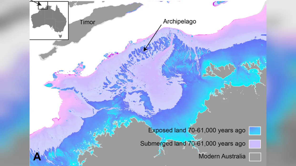
Sea level changes shown as exposed land and unexposed land shown on map of Australian northwest continental shelf.


About 70,000 years ago, a vast swathe of land that's now submerged off the coast of Australia could once have supported a population of half a million people. The undersea territory was so large it could have functioned as a stepping stone for migration from modern-day Indonesia to Australia, finds a new study published Dec. 15 in the journal Quaternary Science Reviews.

"We're talking about a landscape that's quite submerged, over 100 meters [330 feet] below sea level today," Kasih Norman, an archeologist at Griffith University in Queensland, Australia, and lead author on the new study, told Live Science. This Australian "Atlantis" comprised a large stretch of continental shelf that, when above sea level, would have connected the regions of Kimberley and Arnhem Land, which today are separated by a large ocean bay.

This ancient expanded Australian landmass once formed part of a palaeocontinent that connected modern-day Australia, New Guinea, and Tasmania into a single unit known as Sahul.

aerial photo of salt flats on the outskirts of Darwin, Northern Territory, Australia. A small tidal stream drains a mangrove forest with sand dunes and salt flats forming this tidal ecosystem.
A habitable, populated landscape?

Despite its scale, until now there's been little research into whether humans could have inhabited the now-sunken shelf. "There's been an underlying assumption in Australia that our continental margins were probably unproductive and weren't really used by people, despite the fact that we have evidence from many parts of the world that people were definitely out on these continental shelves in the past," Norman said.

Related: Scientists finally discover 'lost continent' thought to have vanished without a trace

Her new study turns that assumption on its head. It brings regional data on sea levels between 70,000 and 9,000 years ago, together with detailed maps of seafloor features from the submerged continental shelf, provided by sonar mapping from ships. This combination painted a picture of dramatically changing conditions on that shelf over the studied period.

Firstly, the data showed that between 71,000 and 59,000 years ago, sea levels were roughly 130 feet (40 m) lower than they are today, a dip that exposed a curving necklace of islands at the Australian continent's outer northwestern edge. This archipelago lay within reaching distance, by voyaging boats, of the Southeast Asian island of Timor, which itself is not far from Indonesia.

Then, between 29,000 and 14,000 years ago, there was another more precipitous dip in sea levels, coinciding with the peak of the last ice age. This was a time when large amounts of water became suspended in ice, which further lowered sea levels. These plummeting levels exposed a large swathe of continental shelf right beside modern-day Australia. "We're really looking at a landmass that was about 1.6 times the size of the UK," Norman said.

This, combined with the previously exposed ring of islands, "would have meant that there was basically a contiguous archipelago environment to move from the Indonesian archipelago, across to Sahul, and then from that archipelago into the supercontinent itself," Norman said. This could have enabled what she called a "staged migration" between modern-day Indonesia and Australia.

Meanwhile, the sonar mapping revealed a landscape where humans could well have thrived: a tall, sheltering escarpment, containing an inland sea adjacent to a large freshwater lake. There was also evidence of winding river beds carved across the land.

Norman calculated that the large shelf, with these life-supporting features, could have harbored anywhere between 50,000 and half a million people. "It's important to bear in mind these aren't real population numbers we're talking about, it's just a matter of projecting the carrying capacity of our landscape," she said. "We're basically saying it could have had that many people."

Remote sandy beaches of Oecusse in Timor-Leste
Retreat and migration

However, there are clues from other research that this once exposed plateau was indeed home to hundreds of thousands of people. Ironically, these come from a time when the potential inhabitants of this Atlantis would have been forced away by rising tides from their new found land.

As the last ice age began to taper off, melting ice caps shed water into a rising sea, Between roughly 14,000 and 14,500 years ago, sea level rose at an accelerating rate, going from about 3.2 feet (1m) per year to a meter [3.2 feet] over the course of 100 years, to 16 feet. "In this 400 year period, over 100,000 square kilometers of land go underwater," Norman said. Between 12,000 and 9,000 years ago, that pattern repeated, and another 100,000 square kilometers were swallowed up by the sea. "People would have really seen the landscape change in front of them, and been pushed back ahead of that encroaching coastline quite rapidly," Norman said.

This hypothesis is supported by other research. A recent study published in the journal Nature analyzed the genetics of people living in the Tiwi Islands, which sit on the edge of the shelf today. It revealed that at the end of the last glacial period, there was change in genetic signatures indicating an influx of new populations there. What's more, about 14,000 years ago, and then again between 12,000 and 9,000 years ago, the archaeological record at edge regions of modern-day Australia shows an increase in the deposit of stone tools — "which is normally interpreted to mean that there's a lot more people suddenly in that area," Norman said.

RELATED STORIES

Zealandia, Earth's hidden continent, was torn from supercontinent Gondwana in flood of fire 100 million years ago

Lost islands beneath the North Sea survived a mega-tsunami 8,000 years ago

Ancient ship and burial ground discovered in underwater city in Egypt

Around this time in Kimberly and Arnhem Land, cave art also changed to incorporate new styles and subjects, including more human figures in the mix. This may have been from new people arriving in the area, Norman said.

She hopes her research will motivate others to pay closer attention to the archeological importance of Australia's sunken continental shelf.

"It's quite fascinating to look at how people dynamically responded to events in the past and obviously survived them and thrived. I would hope that there might be something we can take from that, that we can apply to future climate change and sea level rise in the next few hundred years."


A First-of-Its-Kind 'Pinpoint' Moon Landing Could Happen This Week

George Dvorsky
Wed, January 17, 2024 

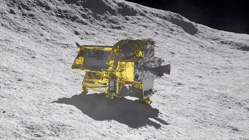
Depiction of SLIM performing its lunar landing.

We’re still reeling from last week’s Astrobotic failure, in which a catastrophic propellant leak rendered the Peregrine lunar lander incapable of completing its Moon landing mission. It’s not the outcome we were hoping for, but the global space community doesn’t have to wait long for another opportunity at lunar exploration success: Japan’s SLIM is slated to attempt an innovative lunar landing this Friday morning.


Scheduled to land on January 19 at 10:20 a.m. EST (Saturday, January 20 at 12:20 a.m. JST), the SLIM, or Smart Lander for Investigating Moon, mission marks a significant milestone for the Japan Aerospace Exploration Agency. In addition to it being JAXA’s inaugural lunar landing attempt, it’s also serving as a pioneering testbed for cutting-edge precision landing technologies.


Depiction of SLIM on the Moon.

JAXA began the SLIM project back in 2013, with the aim of kickstarting Japan’s lunar exploration capabilities. The Planetary Society says it cost about $120 million to develop SLIM. It weighs about 440 pounds (​​200 kilograms) when dry and approximately 1,540 pounds (700 kg) when fueled for launch.

The space agency is seeking to place the lander, built by Mitsubishi Electric, in the Shioli Crater, a 984-foot-wide (300-meter) impact basin. The 20-minute autonomous descent will begin at an altitude of 9.3 miles (15 kilometers), with SLIM traveling at a speed of 3,800 miles per hour (1,700 meters per second). The spacecraft is scheduled to land within a designated area measuring approximately 328 feet by 328 feet, or 100 meters by 100 meters.

According to reporter Jatan Mehta, China’s 2013 Chang’e 3 mission holds the current record for the most accurate Moon landing, whether robotic or human. Its landing ellipse size was 3.73 by 3.73 miles (6 by 6 kilometers), and it impressively landed just 292 feet (89 meters) from its target point. By comparison, India’s 2023 Chandrayaan 3 mission had a landing ellipse that spanned 2.49 by 1.55 miles (4 by 2.5 kilometers). It successfully touched down approximately 1,148 feet (350 meters) away from the designated target spot.

JAXA’s objectives for the SLIM mission include developing a lightweight spacecraft system, testing vision-based navigation essential for high-precision landings, and conducting lunar surface operations to gather knowledge for future exploration.

SLIM encompasses a suite of advanced technologies crucial for a pinpoint lunar landing. These include an advanced guidance and navigation system to ensure trajectory accuracy (including pre-loaded maps, radar, and image processing algorithms) and a high-performance propulsion system for the fine-tuning of approach vectors (i.e., adjusting the spacecraft’s direction and speed) as it approaches the lunar surface. Its hazard detection and avoidance technology will be key to ensuring a safe touchdown.

SLIM is also equipped with tools for studying the lunar surface, including two tiny rovers: Lunar Excursion Vehicle (LEV) 1 and 2. LEV-1 has a camera and is designed to hop on the lunar surface, while Lev-2, also known as SORA-Q, is a tiny transformable robot developed by JAXA, Tomy (the company behind the earliest Transformers toys), Sony Group, and Doshisha University. SLIM is not expected to survive beyond a single lunar day, the equivalent of approximately 14 Earth days, as it wasn’t designed to endure the harsh conditions of a lunar night.

JAXA began landing preparations on January 10, with a successful orbital adjustment on January 14. SLIM is now in a stable 373-mile (600-kilometer) orbit around the Moon, with all systems performing as expected. The upcoming landing is a critical next step for this mission, with JAXA’s control team ready to make real-time adjustments if necessary.

SLIM, should it be successful, will mark an important milestone in space exploration. By enabling high-precision landings, it will enhance our ability to study and understand celestial bodies with unparalleled accuracy. This achievement not only promises more effective research, it also lays the groundwork for future missions that can delve even deeper into the mysteries of the cosmos.

Gizmodo
Japanese scientists capture plants communicating with each other on video

Bryan Ke
Tue, January 16, 2024 


[Source]

A group of Japanese scientists has successfully filmed plants communicating and warning others about potential dangers in real-time, making a breakthrough in an observation first documented in the early 1980s.

What they observed: Published in the journal Nature Communications in October 2023, the research team, led by molecular biologist Masatsugu Toyota from Japan's Saitama University, successfully captured undamaged plants sending defense responses to nearby plants after sensing volatile organic compounds (VOCs), which are produced by other plants in response to mechanical damages or insect attacks.

How the study was conducted: The team, which included Yuri Aratani, a Ph.D. student at the university, and Takuya Uemura, a postdoctoral researcher, attached an air pump to a container filled with leaves and caterpillars and to another chamber containing Arabidopsis thaliana, a common weed from the mustard family. The Arabidopsis was genetically modified to make their cells fluoresce green after detecting calcium ions, which serve as stress messengers. The team then used a fluorescence microscope to monitor the signals the undamaged plants released after receiving VOCs from the damaged leaves.

Trending on NextShark: Celebrities speak out in defense of Jo Koy amid Golden Globes hosting criticism

Why it matters: Plant communication was first observed in a study in 1983, igniting discussions in the scientific community since.

“We have finally unveiled the intricate story of when, where and how plants respond to airborne 'warning messages' from their threatened neighbors,” Toyota said of their recent study. “This ethereal communication network, hidden from our view, plays a pivotal role in safeguarding neighboring plants from imminent threats in a timely manner.”