Wednesday, August 09, 2023

Meet the Persian Gold Tarantula: a new species discovery just on time for Tarantula Appreciation Day 2023


Peer-Reviewed Publication

PENSOFT PUBLISHERS

Persian Gold Tarantula 

IMAGE: NEWLY DESCRIBED TARANTULA SPECIES CHAETOPELMA PERSIANUM, COMMONLY REFERRED TO AS THE PERSIAN GOLD TARANTULA. view more 

CREDIT: KARI KAUNISTO


The Persian Gold Tarantula (Chaetopelma persianum) is a newly described species recently discovered in northwestern Iran. In fact, the “woolly, golden hairs” the scientists observed and examined on a single specimen, were one of the features so unique that it was not necessary for additional individuals to be collected and physically studied. It was clear enough that it was a species previously unknown to the scientific community. 

The paper, authored by Iranian arachnologist and taxonomist Dr Alireza Zamani (University of Turku, Finland) and his Canadian colleague Rick C. West, was published in the peer-reviewed, open-access scientific journal ZooKeys on the observance of the Tarantula Appreciation Day: 8th August. 

The new species belongs to Chaetopelma, a relatively small genus, distributed in Crete, Sudan, and the Middle East. It is also one of the only two tarantula genera inhabiting the Mediterranean region. 

The newly published discovery also presents the first record of this genus in Iran and the third known species of tarantulas in the country. Additionally, it extends the known range of Chaetopelma spiders by almost 350 km eastwards. 

The name of the new to science species, Chaetopelma persianum, pays tribute to its country of occurrence, as Iran has historically been known as Persia. The authors suggest “Persian Gold Tarantula” as a colloquial name for the species.

This tarantula is an obligate burrower and inhabits high elevations in well-vegetated mountainous regions of the northern Zagros Mountains. The collected specimen used to describe the new species was found in a self-made ground burrow on sloped rocky ground, amidst sparse low vegetation and grasses.

It all started with local nature enthusiast Mehdi Gavahyan, who photographed a wandering male and sent the photo to Zamani. Having figured that the spider was likely a species currently unknown to science, the scientist asked Gavahyan to team up with Amir Hossein Aghaei, a nature enthusiast and a friend, and send him specimens of these spiders for further examination. However, Gavahyan and Aghaei managed to only collect and send a single female specimen that would later become the spider used in the species description.

Additionally, thanks to local citizen scientists and naturalists, the authors of the study later got hold of photos of another two males of the same genus, taken very close to the type locality of the new species: one in Sardasht in West Azerbaijan Province of Iran, and the other in the surroundings of Sulaymaniyah in Iraq. While it is highly probable that both these males belong to Chpersianum, this cannot be confirmed until further examination of collected material from both sexes is conducted.

“Looking ahead, we believe that more comprehensive investigations employing integrative methods would greatly benefit our knowledge about the Chaetopelma spiders,”

say the researchers. 

“Additionally, further collection efforts in lesser-sampled or completely unexplored regions, such as Saudi Arabia, Syria, Iraq, eastern Turkey and western Iran, could lead to the discovery of additional Chaetopelma species or records. These findings would be instrumental in gaining a more comprehensive understanding of the taxonomy and distribution of this genus.” 


Research paper:

Tong S, Yang D, Qiu J-W, Ke C, Wang Z (2023) Podarkeopsis chinensis sp. nov. (Annelida, Hesionidae) from southeastern China. ZooKeys 1173: 339-355. https://doi.org/10.3897/zookeys.1173.106112 


The newly described tarantula species (Chaetopelma persianum) seen in a defensive posture.


Burrow of Persian Gold Tarantulas in West Azerbaijan Province, Iran.

Burrow of Persian Gold Tarantulas in West Azerbaijan Province, Iran. The arrow in the photo on the right indicates the location of the burrow.


Habitat of the newly described Persian Gold Tarantula (Chaetopelma persianum) in West Azerbaijan Province, Iran.


CREDIT

Amir Hossein Aghaei


Managing domestic and wildcats is likely to remain fraught, new research warns


Peer-Reviewed Publication

UNIVERSITY OF EXETER


Current efforts to protect and restore native biodiversity is being threatened by difficulties in identifying wild and domestic cats, and categorisation is likely to remain fraught for the foreseeable future, experts have warned.

Efforts to restore the native wildcat (Felis sivestris) are ongoing in Britain and conservationists in New Zealand are also trying to protect native species. Domestic cats pose a threat to other species in both countries. 

The study shows New Zealanders are much less sentimental about pest management to protect native species. As a result domestic cats are treated very differently in the two countries.

Dr Alexandra Palmer, from the University of Auckland, and Dr Virginia Thomas, from the University of Exeter, interviewed those involved with cat conservation in New Zealand and Britain respectively.

In Britain, public opinion is very much against culling feral cats, even in the interests of protecting wildcats. Conservationists are responding to this pragmatically, using ‘trap neuter vaccinte release’ programmes to manage feral cats, rather than culling them. Avoiding culling has the added advantage of ensuring that wildcats aren’t accidentally killed if they’re mistaken for a feral cat. Killing feral cats is legal however, with some game keepers shooting them as part of their predator control programmes.

Wildcats are protected and killing them is an offence, but it can be very difficult to distinguish between domestic and wildcats and this is complicated even further by domestic wildcat hybrids which make legal distinction difficult and render prosecution in cases of wildcat persecution almost impossible under existing legislation.

Different values and attitudes towards cats means that a feral cat is often in the eye of the beholder’ – some people see a cat and assume that its’ feral while others might assume that it’s a wildcat or even a pet cat.

New Zealanders, New Zealand conservationists and even New Zeland cat welfare organisations tend to accept the killing of feral cats in order to protect native species. Pet cats can be killed by mistake if they are accidentally caught in traps intended for feral cats or other ‘pests’. In this case, the legal difficulty is over whether cats are genuinley feral or are stray, and people therefore have a responsibility to protect rather than cull them.  

Dr Palmer carried out 59 interviews and 16 in-depth discussions in New Zealand with conservation project managers and staff, critics of predator control, researchers, Māori stakeholders, and others with relevant interests and expertise. Dr Thomas visited four wildcat breeding facilities across Britain and carried out 26 interviews with those involved with species conservation and management, including conservation communication officers, consultants, practitioners, project managers, policy experts, and researchers.

Dr Thomas said: “In theory and in practice, valued companion and wildcats are distinguished from unprotected feral cats, and in-between categories of stray and hybrid cats. Those responsible draw boundaries between cat categories differently. These differences in boundary-drawing reflect the inherent blurriness of category boundaries, practical challenges, and, importantly, differences in values, in particular whether priority is placed on the life of the cat or the cat’s potential victim, particularly native or game birds. This can mean that laws outlining protections for specific categories of animals have limited effect if, in practice, those encountering cats draw boundaries differently.

“In Britain, it seems unlikely that legal protection of wildcats in theory can be extended to the field without a quick, easy, and reliable method of differentiating between domestic, hybrid, and wildcats. Reducing gaps between law and practice would require seeking agreement from those involved in cat management to stick to the letter of the law, despite this potentially bringing difficult practical implications.”

Research participants in the UK described the “genetic dilution” of the wildcat and its functional extinction.

In the UK there is no legal definition of a wildcat, which makes protecting them extremely difficult. Meanwhile, feral cats may legally be killed at any time, although they are protected under the Animal Welfare Act (2006), meaning that any such killing must be humane. Companion cats are classed as property and are protected by property ownership laws.


Nitrogen runoff strategies complicated by climate change


Rising temperatures may impact nitrogen runoff from land to lakes and streams more than projected increases in total and extreme precipitation

Peer-Reviewed Publication

CARNEGIE INSTITUTION FOR SCIENCE


Washington, DC— As climate change progresses, rising temperatures may impact nitrogen runoff from land to lakes and streams more than projected increases in total and extreme precipitation for most of the continental United States, according to new research from a team of Carnegie climate scientists led by Gang Zhao and Anna Michalak published in the Proceedings of the National Academy of Sciences.

The conditions predicted by these findings are opposite to recent decades, when increasing precipitation has outpaced warming and led to more aquatic nitrogen pollution. Understanding the relative roles of changes in temperature and rainfall is critical for designing water quality management strategies that are robust to climate change while ensuring sustainable food and water supplies.

Human activity has completely altered how nitrogen moves through the planet’s aquatic, terrestrial, and atmospheric systems. Nitrogen from fertilizer washes into waterways and, in excess, can lead to toxin-producing algal blooms or low-oxygen dead zones called hypoxia. Over the past several summers, large algal blooms in lake and coastal regions across the United States have received extensive news coverage.

Carnegie’s Anna Michalak and her team have spent the last decade studying how climate change will affect nitrogen runoff and the subsequent risks posed to water quality. One of the biggest questions for those working to understand and prevent serious water quality impairments is the balance between how changes in temperature and changes in precipitation will affect nitrogen pollution’s ability to get into at-risk waterways.

“The complex soil and aquatic systems through which nitrogen travels, the chemical transformations it undergoes along the way, and the various ways in which changes in temperature and precipitation will affect these processes make nutrient management a big challenge,” Zhao explained.

For example, average and extreme precipitation affects how much nitrogen runs off the land and into waterways, as well as how long it takes for the nitrogen to reach lakes or coastal zones, where it can eventually create dangerous conditions. Temperature also indirectly impacts how much nitrogen ends up in waterways, because warming temperatures increase evaporation, preventing it from going into streams. Temperature also affects how nitrogen interacts with microbial life in the soil and sediment, potentially trapping it there or altering its course.  

“Although the impacts of climate change-induced shifts in precipitation patterns have been explored, the effect of temperature increases on the movement of nitrogen into rivers has not been quantified at continental scales until now due to a lack of available data,” Zhao added.

Zhao, Michalak, and their Carnegie colleagues Julian Merder and Tristan Ballard analyzed several decades of data tracking nitrogen’s movement through river systems across the continental United States and used it to project future trajectories for nitrogen movement under climate change scenarios. They determined that rising temperatures will likely offset, or even decrease, the amount of excess nitrogen flushed into rivers for the majority of the U.S., despite a predicted uptick in precipitation.

These findings are counter to recent decades, when precipitation was the dominant factor over temperature in determining the amount of nitrogen that built up in U.S. waterways. Zhao, Michalak, and their colleagues say that this work forms a critical baseline for future research on the interplay between the nitrogen cycle and climate change.  

“Our research illustrates the complex, and sometimes surprising, ways that climate change affects our planet’s dynamic systems,” Michalak concluded. “Untangling the various factors that are altering the climate change impacts on water quality will help farmers, land managers, and policymakers to pursue the best possible strategies for ensuring that we safeguard water quality, while simultaneously ensuring sustainable food production and water supply.”


Pause in recent coral recovery on much of Great Barrier Reef


In-water monitoring by AIMS shows hard coral cover across the Great Barrier Reef remains at similar levels to that recorded in 2022, with small decreases in the Northern, Central and Southern regions

Reports and Proceedings

AUSTRALIAN INSTITUTE OF MARINE SCIENCE

A scientific observer surveys the Great Barrier Reef 

IMAGE: AN AIMS LONG-TERM MONITORING PROGRAM SCIENTIST SURVEYS A REEF BY MANTA TOW ON THE GREAT BARRIER REEF. view more 

CREDIT: AIMS


In-water monitoring by the Australian Institute of Marine Science (AIMS) shows hard coral cover across the Great Barrier Reef remains at similar levels to that recorded in 2022, with small decreases in the Northern, Central and Southern regions.

Published today (Wednesday 9 August), AIMS’ Annual Summary Report on Coral Reef Condition for 2022/23 found that while some reefs continued to recover, their increased hard coral cover was offset by coral loss on other reefs. Most reefs underwent little change in coral cover.

This follows last year’s report, which saw the Northern and Central regions recording their highest amount of coral cover since AIMS began monitoring 37 years ago.

The pauses in recovery in the Northern and Central regions were due in part to the 2022 mass coral bleaching event. Low numbers of coral-eating crown-of-thorns starfish and a cyclone in January 2022 also contributed to coral loss in the Northern region. Continued crown-of-thorns starfish outbreaks and coral disease kept coral cover similar to last year’s levels in the Southern region, with bleaching playing less of a role.

AIMS Research Program Director Dr David Wachenfeld said that while continued recovery on some reefs was good news, the pause in recovery showed that even relatively milder mass bleaching events had consequences for the Reef.

“The 2022 coral bleaching event was not as severe as the 2016 or 2017 events but caused enough mortality to pause recent regional gains in hard coral cover. The heat stress during the bleaching event also likely had sub-lethal effects, including reductions in coral growth and reproduction,” Dr Wachenfeld said.

“Conditions were relatively mild over the 2023 summer with low levels of coral bleaching and no cyclones crossing the Reef. However, we are only one large scale disturbance away from a rapid reversal of recent recovery.

“The Reef remains a wonderful, complex and beautiful system, but it is at increased risk with climate change driving more frequent and severe bleaching events, putting increasing pressure on the ecosystem’s resilience.”

The Report found the following in average hard coral coverage for 2022/23:

  • Northern region (north of Cooktown) - 35.7%, down from 36.5% last year;
  • Central region (Cooktown to Proserpine) – 30.8%, down from 32.6%;
  • Southern region (south of Proserpine) – 33.8%, down from 33.9%.

Reef slopes on the perimeters of 111 reefs were surveyed between August 2022 and May 2023 for the report under the AIMS Long Term Monitoring Program (LTMP) – a 37-year-long dataset which is the largest, longest and most comprehensive information source on the status of the Great Barrier Reef.

AIMS Long-Term Monitoring Program leader Dr Mike Emslie said recovery over the last few years has been driven primarily, but not exclusively, by fast-growing branching and plate corals, or Acropora. These important habitat builders are also vulnerable to disturbances such as cyclones, crown-of-thorns starfish and coral bleaching.

“Acropora are highly abundant, responsible for most of the ups and downs in hard coral cover, and have been going through a rapid growth phase in recent years. But other corals on the Reef have also contributed to this recovery,” he said.

Dr Emslie noted the increased frequency of mass coral bleaching events on the Great Barrier Reef with four occurring since 2016.

“The 2022 bleaching event was the first ever recorded during a La Niña year, which are usually characterised by cooler temperatures,” he said.

“If there were no disturbances, we would expect the recent increases in coral cover to continue this year. However, this pause indicates that a mass bleaching event, even if less severe, with low mortality, is still enough to put the brakes on this coral recovery.

“This means the Reef is still at risk of decline from more frequent disturbances. AIMS is working to understand the effect of this climatic instability through monitoring and research.”

Dr Wachenfeld added: “The best hope for the future of the Great Barrier Reef and all coral reefs globally requires reduction in greenhouse gas emissions to stabilise temperatures, best practice management of local pressures, and the development of interventions to help boost climate tolerance and resilience for coral reefs.”

BACKGROUND
The LTMP quantifies long term trends in the status of coral communities across the Great Barrier Reef.

Researchers use hard coral cover as one indicator of the condition of each reef, although there are many others. Percentage hard coral cover is estimated by trained scientists during manta tow surveys and is a metric which allows AIMS scientists to provide an overview of the Great Barrier Reef’s status and keep policy makers, managers and other scientists informed in a timely manner.

Manta tow surveys are an efficient way to survey large areas of reef. It is a standard method to assess percent hard coral cover, estimates of crown-of-thorns starfish, levels of coral bleaching, and fish and shark populations.

The LTMP also does detailed surveys on fixed sites on 73 reefs across the Great Barrier Reef. These data provide deeper insights into the corals, fishes and crown of thorns starfish at these sites, their abundance, their age and more detailed information about coral disease and bleaching. 3D images are taken of these reefs to assess reef complexity and their changing structures.

The AIMS monitoring team spent 120 days at sea during this survey period. They travelled 1016km around the perimeter of the 111 reefs they surveyed.

The AIMS LTMP team begin their new survey season in late August. Surveys will continue through the summer and conclude around May 2024.

The LTMP contributes to the Reef 2050 Integrated Monitoring and Reporting Program.


Investors force Black families out of home ownership, new research shows


Peer-Reviewed Publication

GEORGIA INSTITUTE OF TECHNOLOGY

Map 

IMAGE: CONCENTRATION OF INVESTOR-OWNED HOUSING 2013 view more 

CREDIT: GEORGIA TECH


Investors have been buying houses at a steady rate since the last recession, but how much does it affect availability in the housing market? New research from the Georgia Institute of Technology shows investors are most likely to push out Black, middle-class homeowners from neighborhoods.

Data from 800 neighborhoods in the Atlanta metropolitan area between 2007 and 2016 revealed that major investors bought homes in majority-minority neighborhoods far from downtowns and in lower-income areas. These homes were often undervalued because of their minority populations, but they remained desirable and offered good market value.

The neighborhoods where investors bought up real estate were predominantly Black, effectively cutting Black families out of home ownership. Collectively, Black people lost more than $4 billion in home equity over a 10-year period because of investors, according to the research.

“That $4 billion refers to the home values that would have gone to individual homebuyers if these large institutional investment firms hadn’t purchased those properties,” said Brian An, assistant professor in the School of Public Policy. “This is a very conservative, lower estimate than what the actual effect probably is.”

An presented his findings in the paper, “The Influence of Institutional Single-Family Rental Investors on Homeownership: Who Gets Targeted and Pushed Out of the Local Market?,” published in the Journal of Planning Education and Research in June.

The Shrinking Homebuyer Market

Owning a home is one of the main ways for the American middle class to accumulate wealth. Despite this, home ownership declined by 5.5.% between 2007 and 2016. Who owns these homes is even more divided based on race. From 2015 to 2019, homeownership among Black families in the U.S. was 41.7% and for white families 71.7%.

Simultaneously, large private investment firms started buying single-family homes often to flip the houses and rent them at higher rates. Although smaller investment groups often buy homes, the major impact on the market comes from large private institutions.

Analyzing the Data

Investors have long been suspected of buying up substantial portions of the housing market, but determining just how many has been challenging. An used transaction data like buyer names and mailing addresses to determine who property owners were. With a natural language processing tool called OpenRefine that cleans and clusters messy textual data, he combed through millions of observations.

An then analyzed the data with the Herfindahl–Hirschman Index (HHI), a measure of market concentration that can determine the diversity of buyers.

“It means how many properties they are purchasing in one neighborhood,” An said. “For example, let's say there were 500 purchases in the year for single-family houses, then essentially, how many are these large investment firms collectively purchasing? If it’s 500, that is low HHI, meaning a lower market concentration. If it’s only two firms, that’s an extremely high market concentration.”

Using these methods and measures, An showed that, on average, neighborhoods experienced an increase of large investor purchases from nearly 0% in 2007 to over 12% in the peak year, 2013. Investors acquired up to 76% of for-sale, single-family homes in some neighborhoods.  

Institutional investments primarily affected Black families, according to one of An’s models. Results indicated this negative effect is much worse for Black homeownership and totally absent for white homeownership. Whether this is because investment firms mostly purchase in Black neighborhoods or if Black homeowners are specifically targeted is unclear. Regardless of the reasoning, large investors decrease homeownership for anyone in areas they buy out, but especially for Black people.

“Real estate industry stakeholders say these big firms own no more than 3% of total single-family housing stock in the United States, so there is no way that they can suppress home ownership more,” An said. “But if you look at the neighborhood dynamics, there is a lot more concentration in certain neighborhoods that really drives down home ownership.”


An, B.Y. (2023). The Influence of Institutional Single-Family Rental Investors on Homeownership: Who Gets Targeted and Pushed Out of the Local Market? Journal of Planning Education and Research0(0). https://doi.org/10.1177/0739456X231176072


####

The Georgia Institute of Technology, or Georgia Tech, is one of the top public research universities in the U.S., developing leaders who advance technology and improve the human condition. The Institute offers business, computing, design, engineering, liberal arts, and sciences degrees. Its more than 45,000 undergraduate and graduate students, representing 50 states and more than 148 countries, study at the main campus in Atlanta, at campuses in France and China, and through distance and online learning. As a leading technological university, Georgia Tech is an engine of economic development for Georgia, the Southeast, and the nation, conducting more than $1 billion in research annually for government, industry, and society.

Scientists crack the code of what causes diamonds to erupt

New research could spark future diamond discoveries

Peer-Reviewed Publication

UNIVERSITY OF SOUTHAMPTON

Jwaneng Diamond Mine 

IMAGE: JWANENG DIAMOND MINE, BOTSWANA view more 

CREDIT: PROFESSOR TOM GERNON, UNIVERSITY OF SOUTHAMPTON


An international team of scientists led by the University of Southampton has discovered that the breakup of tectonic plates is the main driving force behind the generation and eruption of diamond-rich magmas from deep inside the Earth.

Their findings could shape the future of the diamond exploration industry, informing where diamonds are most likely to be found.

Diamonds, which form under great pressures at depth, are hundreds of millions, or even billions, of years old. They are typically found in a type of volcanic rock known as kimberlite. Kimberlites are found in the oldest, thickest, strongest parts of continents – most notably in South Africa, home to the diamond rush of the late 19th century. But how and why they got to Earth’s surface has, until now, remained a mystery.

The new research examined the effects of global tectonic forces on these volcanic eruptions spanning the last billion years. The findings have been published in the journal Nature. 

Southampton researchers collaborated with colleagues from the University of Birmingham, the University of Potsdam, the GFZ German Research Centre for Geosciences, Portland State University, Macquarie University, the University of Leeds, the University of Florence, and Queen’s University, Ontario.

Tom Gernon, Professor of Earth Science and Principal Research Fellow at the University of Southampton, and lead author of the study, said: “The pattern of diamond eruptions is cyclical, mimicking the rhythm of the supercontinents, which assemble and break up in a repeated pattern over time. But previously we didn’t know what process causes diamonds to suddenly erupt, having spent millions – or billions – of years stashed away 150 kilometres beneath the Earth’s surface.”

To address this question, the team used statistical analysis, including machine learning, to forensically examine the link between continental breakup and kimberlite volcanism. The results showed the eruptions of most kimberlite volcanoes occurred 20 to 30 million years after the tectonic breakup of Earth’s continents.

Dr Thea Hincks, Senior Research Fellow at the University of Southampton, said: “Using geospatial analysis, we found that kimberlite eruptions tend to gradually migrate from the continental edges to the interiors over time at rates that are consistent across the continents.”

Geological processes

This discovery prompted the scientists to explore what geological process could drive this pattern. They found that the Earth’s mantle – the convecting layer between the crust and core – is disrupted by rifting (or stretching) of the crust, even thousands of kilometres away.

Dr Stephen Jones, Associate Professor in Earth Systems at the University of Birmingham, and study co-author said: “We found that a domino effect can explain how continental breakup leads to formation of kimberlite magma. During rifting, a small patch of the continental root is disrupted and sinks into the mantle below, triggering a chain of similar flow patterns beneath the nearby continent.”

Dr Sascha Brune, Head of the Geodynamic Modelling Section at GFZ Potsdam, and a co-author on the study, ran simulations to investigate how this process unfolds. He said: “While sweeping along the continental root, these disruptive flows remove a substantial amount of rock, tens of kilometres thick, from the base of the continental plate.”

The typical migration rates estimated in models matched what the scientists observed from kimberlite records.

“Remarkably, this process brings together the necessary ingredients in the right amounts to trigger just enough melting to generate kimberlites,” added Dr Gernon.

The team’s research could be used to identify the possible locations and timings of past volcanic eruptions tied to this process, offering valuable insights that could enable the discovery of diamond deposits in the future.

Professor Gernon, who was recently awarded a major philanthropic grant from the WoodNext Foundation to study the factors contributing to global cooling over time, said the study also sheds light on how processes deep within the Earth control those at the surface: “Breakup not only reorganises the mantle, but may also profoundly impact Earth's surface environment and climate, so diamonds might be just a part of the story."


Macle twin diamond discovered in Arctic Canada by Tom Gernon

CREDIT

Professor Tom Gernon, University of Southampton

Diamond in its host rock (kimberlite)

CREDIT

Dr Richard Brown, University of Durham

Venetia Diamond Mine, South Africa

CREDIT

Professor Tom Gernon, University of Southampton


FAILED TECHNOLOGY

Carbon Capture and Storage projects in Denmark at risk from bitumen formation

Carbon capture and storage projects in Denmark at risk from bitumen formation
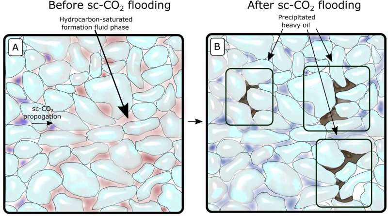
Diagrammatic representation of chalk before and after supercritical carbon dioxide injection,
 with immobile oil and bitumen deposits blocking pores identified in black. 
Credit: Stenshøj et al, 2023.

Carbon Capture and Storage (CCS) is increasingly being cited to help our global warming crisis by reducing greenhouse gas emissions through capturing carbon dioxide and storing deep underground. In the Danish North Sea, chalk rocks below the sea bed hold depleted oil and gas reserves and are now being considered for storing carbon dioxide to capitalize upon the pre-established infrastructure from the fossil fuel industry.

However, new research published in Marine and Petroleum Geology has considered the potential issues arising from interaction of the stored  with oil and gas () residues left in the , which can be up to 30% in chalk and 60% in sandstones.

Rasmus Stenshøj from Aarhus University, Denmark, and colleagues at the Energy & Environmental Research Center, U.S., conducted an experiment on a chalk sample of a few centimeters dating to the Upper Cretaceous (66 to ~100 million years ago) from the Halfdan Field of the North Sea.

The researchers recreated the environmental conditions of the rock from the seabed before injecting  (when it has properties of both a gas and liquid above a certain temperature and pressure) into the rock over a period of nine days. They then used a series of chemical and physical techniques to analyze the hydrocarbons present in rock samples taken before and after supercritical   injection.

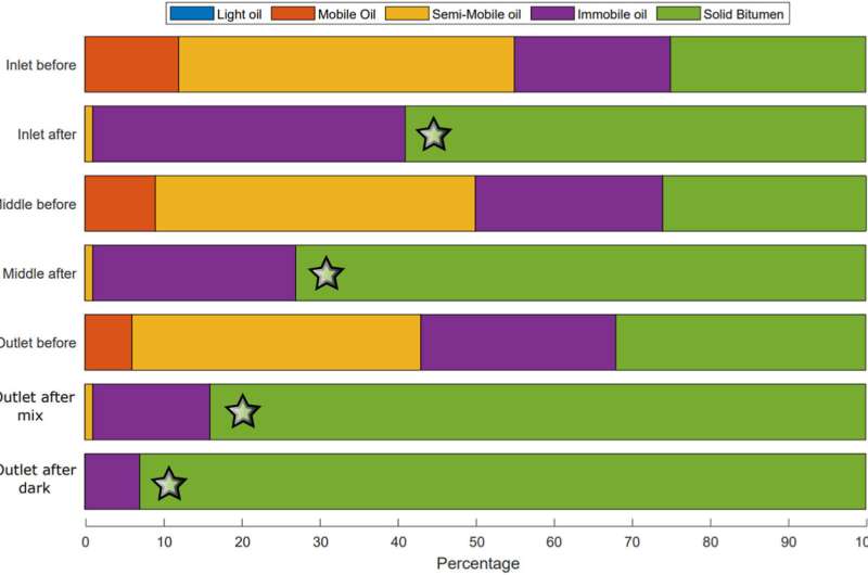
Based upon temperature, different forms of hydrocarbons are present: light oil at 0–100°C, mobile oil at 100–200°C, semi-mobile oil at 200–300°C, immobile oil at 300–375°C and bitumen at 375–650°C.

Initial results revealed that the supercritical carbon dioxide caused lighter hydrocarbons to move through the rock, while heavier forms, such as bitumen and asphaltene-rich immobile oil, were left behind. This can cause blockages in the mobilization of the carbon dioxide through the rock and hamper the efficiency of the Carbon Capture and Storage system.

Importantly, the researchers found that the change in pressure at the exit point of the system resulted in more of the bitumen and other heavy hydrocarbon deposits, comprising up to 10.5% of the total rock volume here, whereas before the experiment this was just 4.17%. There is overall a distinct trend in increasing heavy hydrocarbon deposition through the system up to the exit point, thought to result from absorption of hydrocarbons by the supercritical carbon dioxide changing its solubility. Stenshøj and collaborators term this increasing bitumen from inlet to outlet the Avalanche Effect.

Carbon capture and storage projects in Denmark at risk from bitumen formation
Hydrocarbon rock volume percentages (normalized) for the inlet injection site, the middle of the rock, and the exit outlet before and after supercritical carbon dioxide injection. There is a loss of the lighter hydrocarbons (blue, red and orange boxes) moving through the system while the heavier immobile hydrocarbons and bitumen in particular (purple and green) concentrate towards the outlet. Credit: Stenshøj et al, 2023.


Immobile hydrocarbon and bitumen percentages around the inlet before and after injection are somewhat similar, which the researchers state as evidence of the supercritical carbon dioxide mobilizing through the crude oil phase to extract lighter hydrocarbons for removal through the system, leaving behind the heavier bitumen. It is suggested that this results from a direct pushing force of oil from the carbon dioxide, rather than a splitting force.

Analyzing the samples under a microscope prior to injection revealed the pores in the rock contained a mixture of water and oil, but following supercritical carbon dioxide mobilization of oil, the latter was distributed throughout the rock pores replacing water, and even accumulating in the microscopic shells of the ancient fossils of organisms known as foraminifera. This occurs as the oil is drawn into the water-dominated pores by capillary forces, hence the sample became more oil saturated, which led to a change of color to darker brown.

The solubility of hydrocarbons in response to supercritical carbon dioxide is a complex process, which can be affected by changes in temperature, pressure, hydrocarbon content and clays. Clearly the accumulation of heavier hydrocarbons at exit points can lead to plugging of the Carbon Capture and Storage system, impacting its efficiency. With enhanced research into the siting of these storage systems based upon hydrocarbon content, the possibility of making a real difference to global warming remains a tantalizing one.

More information: Rasmus Stenshøj et al, Hydrocarbon residue in a Danish chalk reservoir and its effects on CO2 injectivity, Marine and Petroleum Geology (2023). DOI: 10.1016/j.marpetgeo.2023.106424

© 2023 Science X Network