Sunday, August 22, 2021


Meet Bella, the new robot serving Richmond diners

Robot replacing servers

A fairly new server has just joined the Hao’s Lamb Restaurant team in Richmond.

And whether she’s in a mood, is rushed off her feet or unhappy about the tip, Bella will always have a smile on her face.

That’s because Bella is a robot, complete with an upward-facing infrared camera and four trays, which she has been busy using to transport dishes to and from the kitchen to hungry diners at the restaurant near Aberdeen Centre.

Once Bella arrives at the table, another staff member helps her remove a dish from one of its trays.

After which, the human staff member hits a confirm button atop the robot’s touchscreen to send it back to the kitchen.

“Although Bella just joined our team, she is super helpful. She allows other human staff to have time to concentrate on other tasks, such as packing takeout orders, greeting guests, clearing tables and refilling water,” said Zhengwen Hao, restaurant owner.

The restaurant “has been operating more efficiently than before. But, as such a hardworking employee, Bella never asks for any tips from me,” laughed Hao, adding that Bella can sing Happy Birthday to customers, in Mandarin and English.

The BellaBot, initially developed by Chinese-based Company Pudu Robotics, was introduced by GreenCo Robots to the North American market, including Richmond.

Hao bought two Bellas amid the pandemic in hopes of easing up the labour shortage and help with social-distancing rules, but he didn’t expect that his Bella could also boost business.

He said younger customers have been trying to interact with Bella, while many others snap photos and video of his new “staff member” hard at work.

Liang Yu, president of Green Co Robots, told the Richmond News that many other local restaurants have invited robots to help them out during the busy season as the economy reopens.

One robot working at another Richmond hotpot restaurant has recorded that she has walked 10,000 metres and served up to 750 trays of dishes to customers within a day, said Yu.

“Robots are a great way to liberate human staff from meaninglessly repetitive and laborious work, allowing them to focus on other more complicated and interesting work, such as talking with guests.”

As for people concerned about the robots taking over from human servers, Yu said they are being introduced to help serve and make customers feel safer, with less human contact during the pandemic.


Cross-border Salish Sea study finds some answers to why wild salmon are dying off

Answers to salmon die off

For millennia, the Salish Sea — the shared body of water linking southern B.C. and northwestern Washington state, and encompassing the Puget Sound, Juan de Fuca Strait and the Strait of Georgia — was abundant with salmon.

The keystone species is the bedrock of the entire ecosystem of the Pacific Northwest. All seven species of Pacific salmon populated the Salish Sea — sustaining a host of other iconic animals, such as bald eagles, ­southern resident killer whales and grizzlies, along with their surrounding aquatic and terrestrial environments and scores of Indigenous nations and cultures.

But, beginning in the late 1970s, salmon survival, particularly for chinook, coho, and steelhead — which migrate to the ocean like salmon, but can spawn multiple times — began a mysterious downward slide, especially in the marine environment, said Isobel Pearsall, ­director of marine science at the Vancouver-based Pacific Salmon Foundation (PSF).

Some populations in Salish waters have plummeted as much as 90 per cent, and limiting fisheries, restoring habitat and improving hatchery practices weren’t­ ­making significant differences, Pearsall said.

It’s clear juvenile fish are particularly vulnerable, and that there is something particular to the Salish Sea impacting survival of the three species, which aren’t facing the same pattern of decline in other regions, she said.

In partnership with Long Live the Kings, another non-profit foundation south of the border, PSF launched a five-year research initiative involving 60 entities to understand what was driving some salmon stocks to extinction and what could be done to reverse it, she said.

Despite the dire situation salmon face, the key ­findings of the recently completed Salish Sea Marine Survival Project can act as a roadmap for priority action, research and policy, said Pearsall, co-ordinator of the initiative.

“It’s very easy to get pulled down into the doom and gloom of what we’re seeing around salmon declines,” Pearsall said. “But the [survival project] has highlighted the areas that we really want to focus on and that we know are crucial.”

The Salish Sea is weathering significant changes due to the climate crisis, such as warming waters, ­increasing risk from harmful algae and pathogens, shifts in the marine food web, and the decimation of estuary and foreshore habitats, the study found. Many of the changes affecting salmon are interlocked, Pearsall said.

“One might hope for a smoking gun and that there would be one major thing you could change to solve the whole issue, but that doesn’t seem to be the case,” she said.

However, the initiative concluded that salmon food supply and predation of young salmon are two key ­contributors to the declines of chinook, coho and steelhead when they first enter the marine environment.

The Salish Sea Marine Survival Project identified the key stressors causing declines of juvenile salmon.

Changes to the Salish Sea affect when, where and how much food is available for young chinook and coho, which influences their growth and mortality.

Drops in zooplankton and forage fish, especially herring, put young salmon at increasing risk, a ­situation compounded by the destruction of estuaries and nearshore habitat, which provide hiding spots and food for both the fish and their prey.

The finding suggests that protecting and restoring estuary and forage fish habitats on the foreshores of the coast should be a priority, Pearsall said.

As well, increased efforts to boost declining herring populations and study their distribution and movements are important.

Young salmon are also under pressure from a growing number of harbour seals in the Salish Sea, the project found.

While chinook and coho are a limited portion of the seals’ diet, the number of seals negatively impacts salmon survival rates, already under strain from human-caused climate change, Pearsall said.

The study doesn’t advocate for widespread culls, which would require the elimination of up to 50 per cent of the seal population, and the constant removal of a significant proportion every year after, to have any real effect on salmon, she said.

“It’s just untenable to make such a drastic move in an ecosystem that nobody fully understands,” Pearsall said. Other pressures and changes are also at play since abundant salmon stocks existed alongside large seal populations in the past, she added.

“I think we need to look at the anthropogenic changes that we’ve made that make the salmon more vulnerable to predation.”

That could include removing infrastructure such as log booms in estuaries where seals can wait for salmon without fear of being eaten themselves. Or by changing hatchery practices, such as the release of large groups of juvenile fish upriver, often in low water, which make young salmon easy pickings for creatures including ­raccoons and herons.

Implementing solutions that could ensure higher river or stream flows to provide more cover and cooler water to young salmon would give them a fighting chance against predators and increase their survival, Pearsall said. The holistic, collaborative nature of the Salish Sea project has resulted in a framework for stakeholders on both sides of the border to respond more effectively in a co-ordinated manner to make gains in restoring ­endangered salmon stocks, she said.

While the study tallies the range of pressures on salmon, it has also pointed out some practical action, Pearsall said.

“We’re letting people know that what they’re doing can have impacts, both negative and positive.

“There may be some things that are out of our ­control, but there are many immediate actions we can take.”


Toxic blaze: the true cost of crop burning


16 AUG 2021 STORY AIR
Photo: 2011CIAT/NeilPalmer / 16 Aug 2021

People around the world are bracing for what has become known as the season of smog.

With autumn around the corner, many countries are entering agricultural crop burning season, where farmers burn their fields to make way for a new crop, sending up plumes of toxic smoke.

These large areas of agricultural lands set ablaze every year are contributing to the air pollution that, according to the World Health Organization (WHO), kills 7 million people a year including 650,000 children.

“Improving the quality of the air we breathe is absolutely necessary to our health and well-being,” says Helena Molin Valdés, Head of the United Nations Environment Programme (UNEP)-hosted Climate and Clean Air Coalition Secretariat. “It is also critical to food security, climate action, responsible production and consumption – and fundamental to equality. In fact, we can’t talk about the 2030 Agenda for Sustainable Development unless we are serious about air quality."

Black carbon

Many farmers consider agricultural burning the most effective and cost-efficient way to clear land, fertilize soil and prepare it for new plantation. However, these blazes and the wildfires that spread from them are the world’s largest source of black carbon, a threat both to human and environmental health.


Improving the quality of air we breathe is absolutely necessary to our health and well-being.
Helena Molin Valdés, Climate and Clean Air Coalition Secretariat


Black carbon is a component of PM2.5, a microscopic pollutant that penetrates deep into the lungs and bloodstream. PM2.5 increases the risk of dying from heart and lung disease, stroke and some cancers, causing millions of people to perish prematurely every year. In children, PM2.5 can also cause psychological and behavioural problems. In older people, it is associated with Alzheimer’s, Parkinson’s disease and dementia. And because air pollution compromises respiratory health, it may also increase vulnerability to COVID-19.

Black carbon is also a short-lived climate pollutant, meaning that, although it exists only for a few days or weeks, its impact on global warming is 460–1,500 times stronger than carbon dioxide.


A better way

Slash and burn agriculture takes a heavy toll on Madagascar’s natural wealth. 
Photo: Global Environment Facility

Ironically, far from stimulating growth, agricultural burning actually reduces water retention and soil fertility by 25 to 30 per cent, and thus requires farmers to invest in expensive fertilizers and irrigation systems to compensate. Black carbon can also modify rainfall patterns, especially the Asian monsoon, disrupting the weather events necessary to support agriculture.

“Burned lands actually have lower fertility and higher erosion rates, requiring farmers to overcompensate with fertilizer,” says Pam Pearson, Director of the International Cryosphere Climate Initiative, which has worked with farmers globally to introduce fire-free cultivation.

“The no-burn alternatives, such as incorporating stubble back into fields or even planting right through the stubble, almost always save the farmer money.”

Pearson notes that changing the long-established habit of burning agricultural waste will require education, awareness-raising and capacity-building for farmers. It is a lofty undertaking, but the impacts would be considerable and far-reaching. Reducing air pollution from farms in Northern India, for example, could prevent increased flooding and drought caused by black carbon accelerating the melting of Himalayan ice and glaciers – a life-changing outcome to the billions who depend on rivers fed by those mountains.

Worldwide effort

The Climate and Clean Air Coalition works in countries and with regional networks to promote alternatives to field burning. In India, for example, it provides farmers with information and assistance to access alternatives to crop fires, using satellites to monitor fires and track their impact, supporting policy interventions, subsidizing farmers and ultimately turning agricultural waste into a resource.

In Punjab, the coalition and the UN Food and Agriculture Organization (FAO) are looking at ways to turn the crop residue that would otherwise be burnt into a renewable fuel source. Creating a circular economy for such waste provides farmers with more income and reduces air pollution.
RELATED


STORY
International Day of Clean Air for blue skies underlines link between healthy air and a healthy planet

Countries around the world are working to reduce air pollution. That drive will be front and centre on 7 September, the International Day of Clean Air for blue skies, which is designed to spur global action against dangerous particulates.

With an eye on global warming and food security, a project called the Koronivia Joint Work on Agriculture is mainstreaming farming into the United Nations Framework Convention on Climate Change. The next round is to take place at the UN Climate Change Conference (COP26), this year.

To learn more about agriculture and air pollution, contact Tiy Chung: tiy.chung@un.org

Every year, on 7 September, the world celebrates the International Day of Clean Air for Blue Skies. The day aims to raise awareness and facilitate actions to improve air quality. It is a global call to find new ways of doing things, to reduce the amount of air pollution we cause, and ensure that everyone, everywhere can enjoy their right to breathe clean air. The theme of the second annual International Day of Clear Air for blue skies, facilitated by the United Nations Environment Programme (UNEP), is “Healthy Air, Healthy Planet.”


'A thrilling sign': Researchers discover secret colony of highly endangered marmots on Vancouver Island

New colony in Strathcona Park of around 10 to 12 individuals has adults, yearlings and pups

There are about 200 Vancouver Island marmot in the wild, up from a low of 27 in 2003. (Marmot Recovery Foundation)

Researchers and conservationists are celebrating after the discovery of a group of Vancouver Island marmots that signals a great step forward in the recovery of the highly endangered species. 

Adam Taylor, executive director of the Vancouver Island Marmot Recovery Foundation, said the discovery of the colony complete with adults, yearlings and pups in Strathcona Park was "a thrilling sign."

"We've been waiting years to see this," Taylor said. 

The Vancouver Island marmot is endemic to the island, and only lives in the high mountains in open alpine habitat. Their populations have plummeted in past decades because of habitat loss, reaching a low of 27 in 2003.

Because of captive breeding programs in the Toronto Zoo, Calgary Zoo and Mount Washington, there are now around 200 individuals in the wild population. 

Taylor says he believes this colony — which has 10 to 12 individuals — is descended from marmots reintroduced to Marble Meadows, about a kilometre away. 

Marmots typically disperse away from their natal colonies, but Strathcona Park has proved tough terrain for the species. They must build massive metres-deep burrows to hibernate in the winter and find enough food to build up the fat layers they need for hibernation. The marmots must also evade hungry predators. 

"Our expectations have been low, to be blunt. It's been a long time of trying to reintroduce these marmots, trying to reestablish colonies that we knew about," said Taylor. 

To see the marmots disperse on their own, pick their own habitat, and managed to successfully establish themselves — and the next generation — is incredible, he said. 

While there have been three new colonies discovered this year, Taylor said the species is still critically endangered. 

"We're still talking about just over 200 individuals in the wild," he said.

The summer has been difficult. Like many other species, the marmot has been hit by the drought, which has curtailed its much needed vegetation for the winter months. August and September are also typically dangerous months for predator activity.

Taylor hopes that the marmots continue their successful dispersal, moving from one colony to the next, reproducing successfully and otherwise thriving. 

"This isn't the end of the road for recovery for this species. It's a good step, though," he said.

With files from On The Island

Attack of the giant rodents or class war? Argentina’s rich riled by new neighbors

Hordes of capybaras have taken up residence at a gated community, sparking a debate on the environment and inequality

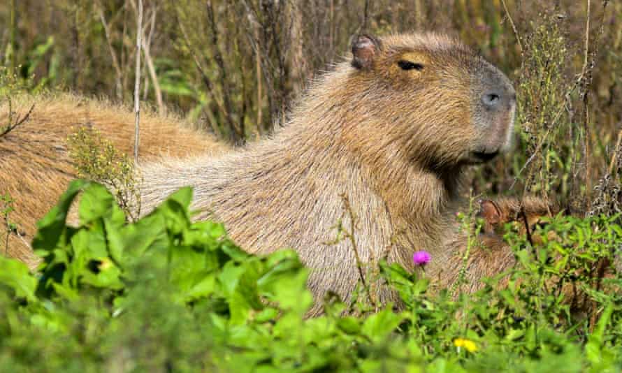
Capybaras, known locally as carpinchos, are the world’s largest rodent
, standing over one 60cm tall and weighing up to 60kg. 
Photograph: Mara Sosti/AFP via Getty Images

Uki Goñi in Buenos Aires
Sun 22 Aug 2021

Nordelta is Argentina’s most well-known gated community: an enclave of spacious homes for the rich amid a dreamy landscape of lakes and streams north of Buenos Aires.

But environmentalists question its very existence because it is built on the wetlands of the Paraná, the second most important river in South America after the Amazon.

Now, however, nature is fighting back against Nordelta’s well-heeled residents.

In recent weeks, the community has been invaded by capybaras, who have destroyed manicured lawns, bitten dogs and caused traffic accidents.

“They not only destroy gardens but their excrement has also become a problem,” one local man told the daily La Nación, complaining that local wildlife officials had prohibited residents from touching the large rodents.


Some Nordelta residents are reported to have responded by bringing out their hunting rifles, but many other Argentinians have taken to social media to defend the rodents – known locally as carpinchos.

In politically polarized Argentina, progressive Peronists see Nordelta as the enclave of an upper class eager to exclude common people – and with tongue only partly in cheek, some have portrayed the capybaras as a rodent vanguard of the class struggle.

“My total support for the Peronist carpinchos of Nordelta recovering
their habitat,” tweeted one internet wag.


Adult capybaras can grow up to one metre (3.2ft) in length, stand over 60cm (24in) tall and can weigh up to 60 kilos (132lb). They are naturally gregarious and live in groups of between 10 and 20 individuals.

Prominent ecologist Enrique Viale said it was a mistake to frame the rodent influx as an invasion. “It’s the other way round: Nordelta invaded the ecosystem of the carpinchos,” said Viale, who has been campaigning with many others for 10 years now for congress to pass a law to defend the wetlands from development.

“Wealthy real-estate developers with government backing have to destroy nature in order to sell clients the dream of living in the wild – because the people who buy those homes want nature, but without the mosquitoes, snakes or carpinchos,” he said.

These vast Paraná wetlands stretch from northern Argentina to the River Plate and the Atlantic Ocean, but have come under attack from urban sprawl as well as cattle and soy mega-farmers who are partly responsible for the wildfires that have destroyed vast areas.

“Nordelta is the supersized paradigm of gated communities built on wetlands. The first thing it does is take away the absorbent function of the land, so when there are extreme weather events, it is the poorer surrounding neighborhoods that end up flooded. As always, it is the poor who end paying the price.”

Vaccine passport debate spills into Alberta's streets

Timm Bruch
CTV News Calgary Video Journalist
Published Saturday, August 21, 2021 

NOW PLAYING
As immunization numbers in Alberta stall, some are calling for an added layer of protection. Timm Bruch explains.


CALGARY -- A debate over whether private businesses should ask for proof of vaccination before allowing access to Albertans is raging on.

Hospitalization numbers in the province ticked up this week, and they continued to reveal a trend: those who are fully vaccinated have far less risk of severe outcomes due to COVID-19.

As immunization numbers stall and the Delta variant impacts more residents, some in the province want an added layer of protection. They say that could come in the form of vaccination proof for admission to services.

"We're in the process of wrestling through the question now of whether or not vaccinations will be mandatory," Knox United Church Reverend Doctor Greg Glatz said. "Part of being a sanctuary, part of being a refuge, is being safe. The vaccination is a way to be safe."

The church is still primarily online, but when in-person worship resumes in mid-September, Glatz says it could ask for proof of vaccination from its congregation.

He says he's well aware of the impact that could have.

"While we are progressive in our theology, we attract people from a broad range of perspectives," Glatz said. "So we are trying to have that dialogue between different perspectives."

While Knox United hasn't yet made a decision, others have.

About 50 people gathered in Calgary's Tomkins Park to speak out against the potential of vaccine passports Saturday night.

They believe the move would take away some of their freedoms. Many at the rally held anti-vaccination signs and spoke of government overreach.

In Quebec, digital vaccine certifications will be required to enter some non-essential services starting in September. It will be used to allow access to events like festivals, and some restaurants, bars and gyms. The passport will store vaccine information that can be accessed through a QR code.

Large companies like Live Nation and MLSE announced this week they will require either proof of vaccination or a negative COVID-19 test at all of their events.

And the issue is already following candidates along the federal election campaign trail.

Alberta's premier made his views clear in July.

“We've been very clear from the beginning that we will not facilitate or accept vaccine passports," Jason Kenney said. "I believe that they would, in principle, contravene the Health Information Act and also possibly the Freedom of Information and Protection of Privacy Act. These folks who are concerned about mandatory vaccines have nothing to be concerned about."

Legal experts say that if done correctly, vaccine passports do not violate privacy laws.

RELATED IMAGES


In this undated photo, provided by NY Governor's Press Office on Saturday March 27, 2021, is the new 'Excelsior Pass' app, a digital pass that people can download to show proof of vaccination or a negative COVID-19 test. (NY Governor's Press Office via AP, File)

ECOCIDE AT DEATH COW

Brazil Discusses Gas Pipeline From Vaca Muerta Shale With Argentina


Brazil is in talks with Argentina about potentially building a $5-billion natural gas pipeline from the Argentinian Vaca Muerta shale play, Brazilian President Jair Bolsonaro said during his weekly live broadcast.

"We are in negotiations with Argentina. Gas from Vaca Muerta. It will happen one day, because it is not easy to start importing gas, you need pipelines," Bolsonaro said, as carried by Reuters.

A pipeline is estimated to cost $3.7 billion in Argentina and another $1.2 billion in Brazil, as per Reuters estimates.

Bolsonaro didn't say how the project would be funded.

A gas pipeline from the prolific Vaca Muerta shale in Argentina's province Neuquén could be one option for reducing natural gas prices in Brazil, according to the Brazilian president.


This year, Brazil is importing a lot of liquefied natural gas (LNG) because of the worst drought in the country in nearly a century.

Brazil is importing so much LNG this year that volumes are close to levels usually seen in countries in Europe and Asia, as the South American country's electricity system grapples with the worst drought in 91 years.

Brazil's electricity mix is heavily dependent on hydroelectric power, which accounted for more than 75 percent of electricity generation in 2020, according to data from the International Energy Agency (IEA).

Brazil has the largest installed hydropower capacity in South America and accounts for two-thirds of the continent's total hydropower capacity.

But this year, Brazil, the most populous country in South America, is experiencing its worst drought in 91 years and is struggling to keep the lights on with hydropower.

At the same time, Vaca Muerta in Argentina is recovering from the pandemic slump and is estimated to hold recoverable resources consisting of 16 billion barrels of oil and 308 trillion cubic feet of natural gas. Those numbers make the Vaca Muerta the world's second-largest shale gas deposit.  

By Charles Kennedy for Oilprice.com

NASA says its Hubble telescope captured a spiral galaxy that's as bright as a jewel and 68 million light-years from Earth

An image of NGC 1385 a spiral galaxy 68 million light-years from Earth
The galaxy is known as NGC 1385. ESA/Hubble & NASA, J. Lee and the PHANGS-HST Team
  • NASA published a "jewel-bright" photo of a spiral galaxy many millions of light-years from Earth.

  • The galaxy - NGC 1385 - is in the Fornax constellation.

  • The constellation's name is Latin for "furnace."

The Hubble Space Telescope captured an image of a "jewel-bright" spiral galaxy, which is 68 million light-years from Earth.

NASA and the European Space Agency published the photo. NASA said in a Friday blog post that it showed NGC 1385, a galaxy in the constellation Fornax.

Hubble's Wide Field Camera 3 - a "workhorse camera" - captured the image, the US space agency said. The camera was installed in 2019 during astronauts most recent Hubble visit, it added.

The name Fornax is not from "an animal or an ancient god," said NASA, but instead comes from the Latin word for furnace.

"The constellation was named Fornax by Nicolas-Louis de Lacaille, a French astronomer born in 1713," the ESA said in text accompanying the photo.

The agency added: "Lacaille named 14 of the 88 constellations we still recognize today. He seems to have had a penchant for naming constellations after scientific instruments, including Atlia (the air pump), Norma (the ruler, or set square), and Telescopium (the telescope).

The photo was the latest in a long succession of beautiful photos captured by the cameras aboard the Hubble Space Telescope during its three decades observing the cosmos.

How climate change will impact the flight of the bumblebee

Brooke Taylor
CTVNews.ca Writer
Published Saturday, August 21, 2021

A bumblebee lands on a poppy flower on a field in Frankfurt, Germany, Friday, May 22, 2020. (AP Photo/Michael Probst)

TORONTO -- Bumblebees' ability to fly for foraging and pollination is being impacted by extreme temperatures at both the high and low end.

Researchers at Imperial College London put bees to the test by measuring the motivation bumblebees had to fly at various temperatures ranging from 12 C to 30 C.

The scientists found that the bumblebees struggled flying further than a few hundred metres at the lower end of temperatures, after which their endurance increased with the temperature until 25 C – at which point the bee flight peaked, according to the study.

For most flying insects, body temperature influences flight activity, and air temperature impacts body temperature. Too cold, and the muscles needed for flight can't work quickly enough, too hot and they overheat, according to a press release.

The results, published in Functional Ecology on Wednesday, show that bumblebees living in more northern regions may stand to have improved flight performance from temperature increases, but those in already hot southern regions will suffer.

“Climate change is often thought of as being negative for bumblebee species, but depending on where in the world they are, our work suggests it is possible bumblebees will see benefits to aspects of an important behaviour," lead study author Daniel Kenna, said in the press release.

While this could be beneficial for some bumblebees, Kenna still cautions that the extreme fluctuations in temperatures could have a negative impact.

"More extreme weather events, such as cold snaps and the unprecedented heatwaves experienced in recent years, could consistently push temperatures beyond the comfortable flight range for certain species of bumblebees," he said.

This could prove to be disastrous for bumblebees and other pollinators who set up shop for the season, and forage around their nest site.

"These risks are particularly pertinent for ‘fixed colony’ pollinators like bumblebees, which cannot shift their position within a season if conditions become unfavourable, and potentially provide a further explanation as to why losses have been observed at species’ southern range limits," added Kenna.

In order to measure flight, the bumblebees were temporarily attached to 'flight mills'. Once attached they were able to fly in circles which allowed researchers to capture the distance and speed of flight, they used these results to create a thermal performance curve.

They found that at optimal temperatures, average bumblebee flight was around 3 kilometres. If temperatures rose to 35 C, flight distance would drop to 1 kilometre, and plummet even further, to just a few hundred metres at 10 C. At the colder temperatures, the researchers found that only the largest worker bees would fly.

"While we still need to understand how these findings translate to factors like foraging return to colonies and pollination provision, as well as applicability to other bumblebee species, the results can help us understand how smaller versus larger flying insects will respond to future climate change," Richard Gill, from the department of Life Sciences at Imperial College, said in a press release.

This could have far-reaching implications beyond pollinating insects, he added.

"It’s not just pollination: how different flying insects respond to warming temperatures could also affect the spread of insect-borne diseases and agricultural pest outbreaks that threaten food systems," said Gill. "Applying our experimental setup and findings to other species can help us to understand future insect trends important for managing service delivery or pest control methods.”


Home seismometers provide crucial data on Haiti’s quake

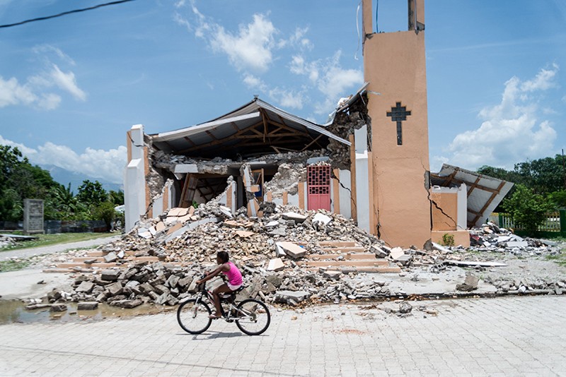
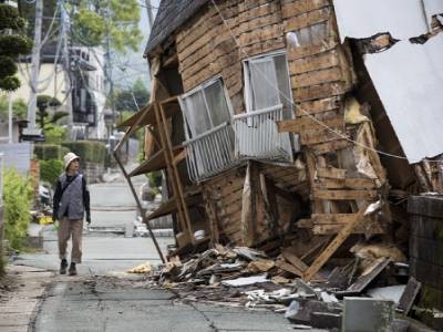
A child rides a bike on the road in front of a church that has been demolished by an earthquake in Chardonnieres, Haiti.

The earthquake in Haiti this month has destroyed many buildings, such as the Church St. Anne in Chardonnières, shown here.Credit: Reginald Louissaint Jr/AFP via Getty

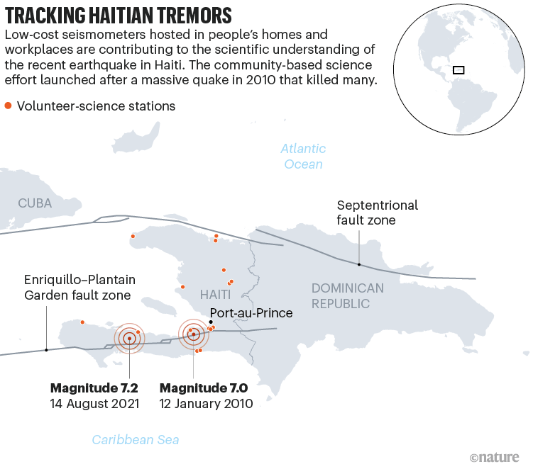
A network of inexpensive seismometers, installed in people’s living rooms, gardens and workplaces across Haiti, is helping scientists to unravel the inner workings of the magnitude-7.2 earthquake that devastated the southwestern part of the Caribbean nation this month. The community-science effort launched after the country’s last major earthquake — a magnitude-7 tremor in 2010 that killed more than 100,000 people — and has since helped to reveal details about Haiti’s seismic activity.

In a country whose official seismic-monitoring stations are sometimes offline because of limited resources, the community-seismology project provides much-needed data. Right now, the network is detecting aftershocks that continue to rattle the region. Its seismometers feed data into a system that displays the locations and magnitudes of Haitian earthquakes on a web-based portal in real time.

“It’s not professional equipment, and there are a lot of limitations,” says Dominique Boisson, a geologist at the State University of Haiti in Port-au-Prince who helps to run the network. But “some results are very nice”.

Difficult work

The network underscores just how far seismology in Haiti has come in 11 years. When the 2010 earthquake struck near Port-au-Prince, the country had no seismologists and just one official seismic-monitoring station, says Boisson. Now, there are several professional seismologists, as well as 7 stations in the official national network, which is operated by Haiti’s Bureau of Mines and Energy, and 15 in the community-science network.

Tracking Haitian Tremors. Map showing the locations of seismometers in Haiti.

Sources: C. S. Prentice et al. Nature Geosci. 3, 789–793 (2010)/Ayiti-Séismes

Within days of the big quake hitting on 14 August, teams of scientists and technicians were driving towards its epicentre, carrying seismometers and other instruments to measure how the ground was moving. Monitoring the Earth with scientific instruments immediately after a quake allows researchers to better understand why the earthquake occurred and the future seismic risk. In 2010, it took weeks after the quake for foreign researchers to fly to Haiti and deploy instruments.

This year, many of those foreign teams are forbidden to travel to Haiti because of COVID-19 restrictions and political instability following the assassination in July of Haiti’s president, Jovenel Moïse. Instead, the work is being led by Haitian seismologists, such as Steeve Symithe, also at the State University, who, before he went into the field, was streaming Facebook Live presentations about the science of the quake to the Haitian public.

Both the 2010 and 2021 quakes happened in the Enriquillo–Plantain Garden fault zone, a tangle of fractures in Earth’s crust where the North American and Caribbean tectonic plates slide past one another. It runs from west to east along Haiti’s southern peninsula. The 2010 quake occurred on a previously unknown fault in that zone. The epicentre of the 2021 quake lies about 100 kilometres to the west, in the province of Nippes.

At least 2,100 people died in the 14 August quake, although the total count has yet to be tallied. The US Geological Survey estimates that there might have been more than 10,000 deaths. Many survivors endured heavy winds and rain from a tropical storm as they tried to shelter outside. The scientists en route to the area spent the night in their cars as rain pelted down, softening the ground and generating landslides as aftershocks shook the ground, Boisson tells Nature. “It was pretty difficult” for them, he says.

DIY seismology

The challenge of doing fieldwork in Haiti helped to inspire the creation of the community-seismology project in 2019. That was when Eric Calais, a seismologist at the École Normale Supérieure in Paris who has studied Haiti’s earthquakes for years, happened across a company that sells seismic stations to hobbyists. Looking for ways around the national Haitian network’s intermittent data, he used leftover money from a grant to buy some stations. Known as Raspberry Shakes, they contain tiny accelerometers that detect when the ground trembles and send that information to be processed and commingled with that from other stations.

These US$500 stations are not as sophisticated as Haiti’s official $50,000 monitoring stations. “But when it comes to locating quakes, determining magnitude, doing basic seismology — they are really excellent,” says Calais. And because they are in people’s homes and workplaces, they more often have a steady supply of power and reliable Internet access. The team, which includes Calais, Boisson, Symithe and many others, recruited people to host the stations. Boisson had one in his garden until last week, when he dismantled it to move it closer to the epicentre of the 14 August quake. The host who had the Raspberry Shake closest to the epicentre was chagrined that his station was offline during the quake; he immediately ran out and topped up his Internet plan, says Calais, and the station was soon back up and running.

Funded by international supporters, Calais and his colleagues have kept the network of 15 stations operational for two years1; they aim to soon ramp up to 50 or more stations. Community-seismology networks have sprung up in other places around the world, but the Haiti network is unique in providing data in an area where few seismic data are otherwise collected, says Calais.

The Haitian community-seismology data feed into a nationwide experimental system called Ayiti-Séismes, which is hosted at a website run by the Côte d’Azur University in Nice, France. Ayiti-Séismes also pulls data from official seismic stations in Haiti as well as those in nearby countries, including the Dominican Republic and Cuba. The result is a real-time map of aftershocks blanketing southwestern Haiti in shades of red and orange. “The network is alive and well,” says Susan Hough, a seismologist at the US Geological Survey in Pasadena, California, who has worked in Haiti for many years, including after the 2010 quake.

Future risk

The quake’s epicentre is fairly close to quakes that occurred in 1952 and 1953, which were probably between magnitude 5 and 6, says Calais. In terms of future risk, the Enriquillo–Plantain Garden fault zone could still yield another major quake. “In this area, we cannot say that it’s over,” says Boisson. Some speculate that the 2010 quake contributed to the recent one by transferring stress towards the region that just ruptured — and that seismic risk remains high in Port-au-Prince and across much of the Enriquillo–Plantain Garden fault zone.

Boisson notes that many scientists have been worried about a different major geological region in Haiti’s north, known as the Septentrional fault zone; it unleashed a major quake in 1842. “After 2010, we thought it would be this fault” that would cause future quakes, he says. “And then it was in the south again.”

About 600 aftershocks have been detected from the 14 August quake so far — compared with roughly 10 in the same time period after the 2010 quake, although there were undoubtedly more that were not detected, says Calais. “We now have very strong information about not only where the [14 August] quake occurred, but also how wide the rupture was, in which direction the fault was dipping,” he adds. “That’s essential” to understanding why the quake occurred and what to expect in the future.

doi: https://doi.org/10.1038/d41586-021-02279-y

References

  1. 1.

    Calais, E. et al. Front. Earth Sci. https://doi.org/10.3389/feart.2020.542654 (2020).