Showing posts sorted by date for query LEMURIA. Sort by relevance Show all posts

Wednesday, January 17, 2024

Lost 'Atlantis' continent off Australia may have been home for half a million humans
70,000 years ago


Emma Bryce
Tue, January 16, 2024 

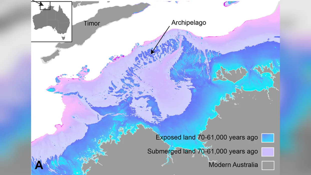
Sea level changes shown as exposed land and unexposed land shown on map of Australian northwest continental shelf.


About 70,000 years ago, a vast swathe of land that's now submerged off the coast of Australia could once have supported a population of half a million people. The undersea territory was so large it could have functioned as a stepping stone for migration from modern-day Indonesia to Australia, finds a new study published Dec. 15 in the journal Quaternary Science Reviews.

"We're talking about a landscape that's quite submerged, over 100 meters [330 feet] below sea level today," Kasih Norman, an archeologist at Griffith University in Queensland, Australia, and lead author on the new study, told Live Science. This Australian "Atlantis" comprised a large stretch of continental shelf that, when above sea level, would have connected the regions of Kimberley and Arnhem Land, which today are separated by a large ocean bay.

This ancient expanded Australian landmass once formed part of a palaeocontinent that connected modern-day Australia, New Guinea, and Tasmania into a single unit known as Sahul.

aerial photo of salt flats on the outskirts of Darwin, Northern Territory, Australia. A small tidal stream drains a mangrove forest with sand dunes and salt flats forming this tidal ecosystem.
A habitable, populated landscape?

Despite its scale, until now there's been little research into whether humans could have inhabited the now-sunken shelf. "There's been an underlying assumption in Australia that our continental margins were probably unproductive and weren't really used by people, despite the fact that we have evidence from many parts of the world that people were definitely out on these continental shelves in the past," Norman said.

Related: Scientists finally discover 'lost continent' thought to have vanished without a trace

Her new study turns that assumption on its head. It brings regional data on sea levels between 70,000 and 9,000 years ago, together with detailed maps of seafloor features from the submerged continental shelf, provided by sonar mapping from ships. This combination painted a picture of dramatically changing conditions on that shelf over the studied period.

Firstly, the data showed that between 71,000 and 59,000 years ago, sea levels were roughly 130 feet (40 m) lower than they are today, a dip that exposed a curving necklace of islands at the Australian continent's outer northwestern edge. This archipelago lay within reaching distance, by voyaging boats, of the Southeast Asian island of Timor, which itself is not far from Indonesia.

Then, between 29,000 and 14,000 years ago, there was another more precipitous dip in sea levels, coinciding with the peak of the last ice age. This was a time when large amounts of water became suspended in ice, which further lowered sea levels. These plummeting levels exposed a large swathe of continental shelf right beside modern-day Australia. "We're really looking at a landmass that was about 1.6 times the size of the UK," Norman said.

This, combined with the previously exposed ring of islands, "would have meant that there was basically a contiguous archipelago environment to move from the Indonesian archipelago, across to Sahul, and then from that archipelago into the supercontinent itself," Norman said. This could have enabled what she called a "staged migration" between modern-day Indonesia and Australia.

Meanwhile, the sonar mapping revealed a landscape where humans could well have thrived: a tall, sheltering escarpment, containing an inland sea adjacent to a large freshwater lake. There was also evidence of winding river beds carved across the land.

Norman calculated that the large shelf, with these life-supporting features, could have harbored anywhere between 50,000 and half a million people. "It's important to bear in mind these aren't real population numbers we're talking about, it's just a matter of projecting the carrying capacity of our landscape," she said. "We're basically saying it could have had that many people."

Remote sandy beaches of Oecusse in Timor-Leste
Retreat and migration

However, there are clues from other research that this once exposed plateau was indeed home to hundreds of thousands of people. Ironically, these come from a time when the potential inhabitants of this Atlantis would have been forced away by rising tides from their new found land.

As the last ice age began to taper off, melting ice caps shed water into a rising sea, Between roughly 14,000 and 14,500 years ago, sea level rose at an accelerating rate, going from about 3.2 feet (1m) per year to a meter [3.2 feet] over the course of 100 years, to 16 feet. "In this 400 year period, over 100,000 square kilometers of land go underwater," Norman said. Between 12,000 and 9,000 years ago, that pattern repeated, and another 100,000 square kilometers were swallowed up by the sea. "People would have really seen the landscape change in front of them, and been pushed back ahead of that encroaching coastline quite rapidly," Norman said.

This hypothesis is supported by other research. A recent study published in the journal Nature analyzed the genetics of people living in the Tiwi Islands, which sit on the edge of the shelf today. It revealed that at the end of the last glacial period, there was change in genetic signatures indicating an influx of new populations there. What's more, about 14,000 years ago, and then again between 12,000 and 9,000 years ago, the archaeological record at edge regions of modern-day Australia shows an increase in the deposit of stone tools — "which is normally interpreted to mean that there's a lot more people suddenly in that area," Norman said.

RELATED STORIES

Zealandia, Earth's hidden continent, was torn from supercontinent Gondwana in flood of fire 100 million years ago

Lost islands beneath the North Sea survived a mega-tsunami 8,000 years ago

Ancient ship and burial ground discovered in underwater city in Egypt

Around this time in Kimberly and Arnhem Land, cave art also changed to incorporate new styles and subjects, including more human figures in the mix. This may have been from new people arriving in the area, Norman said.

She hopes her research will motivate others to pay closer attention to the archeological importance of Australia's sunken continental shelf.

"It's quite fascinating to look at how people dynamically responded to events in the past and obviously survived them and thrived. I would hope that there might be something we can take from that, that we can apply to future climate change and sea level rise in the next few hundred years."


Wednesday, December 20, 2023


Mysterious fruit shown to be the oldest known fossils of the Frankincense and Myrrh family


Peer-Reviewed Publication

FLORIDA MUSEUM OF NATURAL HISTORY

Image 1 

IMAGE: 

PRIOR TO THE WIDESPREAD USE OF CT SCANNING IN PALEONTOLOGY, SMALL FOSSILS LIKE THESE, WHICH ARE LESS THAN 10 MM IN DIAMETER, WERE ESPECIALLY DIFFICULT TO STUDY AND IDENTIFY.

view more 

CREDIT: PHOTO BY STEVEN MANCHESTER


Early in the 1970s, a paleontologist working on the outskirts of an Indian village found small, bead-like fossils embedded in the gray chert dotting the surrounding fields. The site was notorious for turning up plant fossils that were difficult to identify, including the fruit of an extinct species resignedly given the name “Enigmocarpon.” The new fossils proved just as frustratingly intractable; more of them were discovered in India over the next several decades, but scientists had little luck deciding what type of plant they belonged to.

Now, researchers say they’ve solved the mystery. Using CT scanning technology, Steven Manchester, curator of paleobotany at the Florida Museum of Natural History, created 3D reconstructions of the original fossil specimens and others collected since. He showed these to a colleague, who noticed something odd about the five triangular seeds inside.

“When I showed him the 3D images, he said “those aren’t seeds. Those are pyrenes,” Manchester recalled of his conversation with courtesy curator of botany at the Florida Museum, Walter Judd.

Pyrenes are woody dispersal pods that give seeds an extra layer of protection. Examples include the hard stones at the cores of cherries, peaches, dates and pistachios, which prevent the seeds from being digested along with the rest of the fruit.

Distinguishing a seed from a pyrene, especially when they’re the size of snowflakes, requires close scrutiny. Traditional methods of paleobotany, which involve incrementally dissolving fossils in acid and observing each new layer under a microscope, had proven insufficient.

“If we had specimens that fractured at just the right plane, I would have been able to recognize them, but with the material we had on hand, I couldn’t tell,” Manchester said.

There are only a few plant groups that produce pyrenes, fewer still with fruits that contain five seeds arranged in a pentagram. Through a process of elimination, Manchester and Judd determined the fossils belonged to an extinct species in Burseraceae, the Frankincense family.

Fossilized wood, leaves, fruits and flowers from this family have been found elsewhere in India, often sandwiched between thick slabs of basalt created by one of the largest volcanic eruptions in Earth’s history.

LEMURIA

At the time, India was an island off the southeast coast of Africa. India’s continental plate was slowly inching toward Europe and Asia, and as it rafted past Madagascar, it broke the seal on a thin layer of Earth’s crust. Rivers of liquid rock poured onto a landscape the size of California and Texas combined. The eruptions occurred intermittently for nearly a million years, and they repeatedly killed any vegetation that grew during the interludes.

“The fossils were preserved at times of quiet between the eruptions,” Manchester said. “Ponds and lakes formed on the relatively fresh lava flows, and vegetation, including wood and seeds, were washed into them and covered by sediment.”

The shield volcano responsible for the destruction was active just before and after the asteroid impact that drew the curtains on the Cretaceous, and both are thought to have contributed to the extinctions that followed.

Most fossils from the Frankincense family have, up until now, been recovered from rocks that postdate the asteroid impact. The original fruits discovered in the 1970s were fossilized before that event. This makes them the oldest Burseraceae fossils discovered to date, which has important implications for the family’s origin. Scientists have a good idea of when plants in the group initially evolved, but it’s still unclear where they came from.

Ancient species of Burseraceae are a common component of fossil beds in southern England, the Czech Republic and parts of North America. Beginning roughly 50 million years ago, however, Earth’s climate began a long cooling process that ultimately resulted in the most recent Ice Ages. As temperatures fell, species in the Frankincense family seemed to reverse their preference for hemispheres. Today, there are more than 700 Burseraceae species, and most of them grow south of the equator.

The ancestors of modern Burseraceae species are thought to have first appeared somewhere in the north. Alternatively, a few early species may have had a global distribution but became isolated as continents drifted apart.

The fossils from India suggest the southern hemisphere may have been the real birthplace of the family.

“It could be that we just don't have rocks of the right age in Europe to indicate that they were there, but this shows that we can't dismiss the southern hemisphere as a point of origin,” Manchester said.

Tuesday, October 24, 2023

Argoland: Unraveling the mysteries of a lost continent


10-23-2023
ByChrissy Sexton
Earth.com staff writer

Geologists have long been intrigued by a missing piece of Earth’s history – a lost continent called Argoland. Around 155 million years ago, a 5,000-kilometer chunk broke off of western Australia and began its solitary drift.

The void that was left behind is marked by a basin deep below the ocean known as the Argo Abyssal Plain. But, where did Argoland actually go?

A new study from Utrecht University reveals that while Argoland might not exist as a singular mass today, it has not vanished entirely.
The journey of Argoland

Scientists have relied on the underwater Argo Abyssal Plain as evidence of Argoland’s past existence. The seabed structure suggests that the detached continent drifted northwestward, potentially towards present-day Southeast Asia.

But the mystery deepens, as the vast continent-sized footprint of Argoland is conspicuously absent beneath Southeast Asian islands. Instead, these islands sit atop smaller continental fragments, encircled by significantly older oceanic basins.

This led geologists to dive deeper into the fate of Argoland. They found that the lost continent hasn’t completely disappeared – it has simply shattered into fragments.
Earth’s hidden tales

Earth’s crust varies in weight, comprising heavier oceanic sections and lighter continental chunks. Interestingly, these lighter portions might be lurking below sea level, much like Greater Adria, another lost continent.

Greater Adria’s journey ended when it submerged into the Earth’s mantle, leaving its top layer behind, which later morphed into the mountains of Southern Europe. Argoland, by contrast, left no evidence in the form of folded rocks.
Study significance

Utrecht University geologist Douwe van Hinsbergen emphasized the significance of tracing these continents.

“If continents can dive into the mantle and disappear entirely, without leaving a geological trace at the Earth’s surface, then we wouldn’t have much of an idea of what the Earth could have looked in the geological past. It would be almost impossible to create reliable reconstructions of former supercontinents and the Earth’s geography in foregone eras,” said van Hinsbergen.

“Those reconstructions are vital for our understanding of processes like the evolution of biodiversity and climate, or for finding raw materials. And at a more fundamental level: for understanding how mountains are formed or for working out the driving forces behind plate tectonics; two phenomena that are closely related.”
Islands of information

Van Hinsbergen and his colleague Eldert Advokaat were curious about what the geology of Southeast Asia may reveal about Argoland.

“But we were literally dealing with islands of information, which is why our research took so long. We spent seven years putting the puzzle together,” said Advokaat.

“The situation in Southeast Asia is very different from places like Africa and South America, where a continent broke neatly into two pieces. Argoland splintered into many different shards. That obstructed our view of the continent’s journey.”

Fragmented continent

But then, Advokaat realized that these fragments converged at their current locations simultaneously, painting a once cohesive picture. Today, the remnants of Argoland can be found beneath the jungles of Indonesia and Myanmar.

This fragmentation was characteristic. Argoland was never a single, solid landmass. Instead, it was an ‘Argopelago,’ a collection of microcontinental chunks interspersed with older oceanic basins. This aspect aligns with other known entities like Greater Adria and Zeelandia.

An evolving planet

The investigation by Advokaat and Van Hinsbergen seamlessly links the geological systems between the Himalayas and the Philippines. Their explorations unravel why Argoland fragmented so intensely.

Around 215 million years ago, the continent underwent rapid fracturing, breaking into slender splinters. This theory was further supported through field studies on islands such as Sumatra, Borneo, and Timor.

The story of Argoland is not one of complete disappearance but of transformation. As the world continues to evolve, this lost continent serves as a compelling reminder of the ever-shifting nature of our planet.

The study is published in the journal Gondwana Research.


GONDWANA’S SECRET: 390-MILLION-YEAR-OLD MARINE MYSTERY UNRAVELED

2023-10-23 02:24 PM by Daisy Hips


During the Early-Middle Devonian, Gondwana was a warm, flooded landmass at the South Pole, home to the now-extinct Malvinoxhosan biota. New research has revealed these species’ decline correlated with sea-level and temperature changes. Their extinction, likely due to disrupted ocean barriers and an influx of warm-water species, led to an irreversible collapse of polar ecosystems. Similar patterns have been observed in South America, underscoring the lasting sensitivity of polar regions to environmental shifts.

During the Early-Middle Devonian period, a large landmass called Gondwana—which included parts of today’s Africa, South America, and Antarctica—was located near the South Pole. Contrary to the frosty environment we see today, the climate was warmer, and elevated sea levels submerged much of its terrain.

THE MALVINOXHOSAN BIOTA MYSTERY


The Malvinoxhosan biota were a group of marine animals that thrived in cooler waters. They included various types of shellfish, many of which are now extinct. “The origin and disappearance of these animals have remained an enigma for nearly two centuries until now,” says Dr. Penn-Clarke.

The researchers collected and analyzed a vast amount of fossil data. They used advanced data analysis techniques to sort through layers of ancient rock based on the types of fossils found in them. Imagine it like sorting through layers of a cake, each with different ingredients.

Simplified diagram showing the relationship between changes in sea-level and environment with biodiversity through time in South Africa during the Early-Middle Devonian. Credit: GENUS: DSI-NRF Centre of Excellence in Palaeosciences

They then identified at least 7 to 8 distinct layers, each showing fewer and fewer types of marine animals over time. These findings were then compared with how the environment and sea levels have changed, as well as with global temperature records from that ancient period. They found that these marine animals went through several phases of declining numbers of different species, which correlated with changes in sea levels and climate. It was a difficult process.

“This research is around 12-15 years in the making, and it wasn’t an easy journey,” shares Dr. Penn-Clarke. “I was only able to overcome all the different challenges through dogged persistence and perseverance.”

THEORIES ON MARINE LIFE ADAPTATION


Their research suggests that the Malvinoxhosan biota survived during a long period of global cooling. Dr. Penn-Clarke elaborates, “We think that cooler conditions allowed for the creation of circumpolar thermal barriers—essentially, ocean currents near the poles—that isolated these animals and led to their specialization.”

As the climate warmed up again, these animals disappeared. They were replaced by more generalist marine species that are well-adapted to warmer waters. Shifts in sea levels during the Early-Middle Devonian period probably disrupted natural ocean barriers that had kept waters cooler at the South Pole.

Inset images are of common invertebrate fossils found in South Africa. Clockwise from left: Brachiopod shell bed of Australospirifer and Australocoelia, the trilobite Eldredgeia, brachiopod shells of Rhipidothyris, an ophiuroid bed. At centre is an enrolled trilobite assigned to Burmiesteria. Image credits: Geographic reconstruction after Penn-Clarke and Harper (2023), fossil photographs by Cameron Penn-Clarke and John Almond. Credit: GENUS: DSI-NRF Centre of Excellence in Palaeosciences

This allowed warmer waters from regions closer to the equator to flow in, setting the stage for marine animals that thrive in warmer conditions to move into these areas. As a result, these warm-water species gradually took over, leading to the decline and eventual disappearance of the specialized, cool-water Malvinoxhosan marine animals.

IMPACT ON POLAR ECOSYSTEMS

The extinction of the Malvinoxhosan biota led to a complete collapse in polar ecosystems, as biodiversity in these regions never recovered.

“This suggests a complete collapse in the functioning of polar environments and ecosystems to the point that they could never recover,” Dr. Penn-Clarke adds.

He likens this research to playing a game of Clue.

“It’s a 390-million-year-old murder mystery. We now know that the combined effects of changes in sea level and temperature were the most likely ‘smoking gun’ behind this extinction event,” he notes. It is still unknown if this extinction event can be correlated with known extinction events at the same time elsewhere during the Early-Middle Devonian as researchers simply do not have any real good age inferences. The mystery deepens further, and it is far from over.

Interestingly, similar declines in biodiversity controlled by sea-level changes have been observed in South America. This points to a broader pattern of environmental change affecting the South Polar region during this period and underscores the vulnerability of polar ecosystems, even in the past.

“This research is important when we consider the biodiversity crisis we are facing in the present day,” says Dr. Penn-Clarke. “It demonstrates the sensitivity of polar environments and ecosystems to changes in sea level and temperature. Any changes that occur are, unfortunately, permanent.”

Reference: “The rise and fall of the Malvinoxhosan (Malvinokaffric) bioregion in South Africa: Evidence for Early-Middle Devonian biocrises at the South Pole” by Cameron R. Penn-Clarke and David A.T. Harper, 13 October 2023, Earth-Science Reviews.
DOI: 10.1016/j.earscirev.2023.104595

The study was funded by the GENUS: DSI-NRF Centre of Excellence in Palaeosciences, the National Research Foundation, and the Leverhulme Trust.


Saturday, August 19, 2023

A dramatic volcano eruption changed lives in Fiji 2,500 years ago—100 generations have kept the story alive

by Patrick D. Nunn, The Conversation
The hole made when a spear was thrown by one god at the other, on the north coast of eastern Kadavu. 
Credit: Patrick D. Nunn CC BY-ND.

Can you imagine a scientist who could neither read nor write, who spoke their wisdom in riddles, in tales of fantastic beings flying through the sky, fighting each another furiously and noisily, drinking the ocean dry, and throwing giant spears with force enough to leave massive holes in rocky headlands?

Our newly published research in the journal Oral Tradition shows memories of a volcanic eruption in Fiji some 2,500 years ago were encoded in oral traditions in precisely these ways.


They were never intended as fanciful stories, but rather as the pragmatic foundations of a system of local risk management.

Life-changing events


Around 2,500 years ago, at the western end of the island of Kadavu in the southern part of Fiji, the ground shook, the ocean became agitated, and clouds of billowing smoke and ash poured into the sky.

When the clouds cleared, the people saw a new mountain had formed, its shape resembling a mound of earth in which yams are grown. This gave the mountain its name—Nabukelevu, the giant yam mound. (It was renamed Mount Washington during Fiji's colonial history.)

So dramatic, so life-changing were the events associated with this eruption, the people who witnessed it told stories about it. These stories have endured more than two millennia, faithfully passed on across roughly 100 generations to reach us today.

Scientists used to dismiss such stories as fictions, devalue them with labels like "myth" or "legend". But the situation is changing.

Today, we are starting to recognize that many such "stories" are authentic memories of human pasts, encoded in oral traditions in ways that represent the worldviews of people from long ago.

Nabukelevu from the northeast, its top hidden in cloud. Inset: Nabukelevu from the west in 1827 after the drawing by the artist aboard the Astrolabe, the ship of French explorer Dumont d’Urville. It is an original lithograph by H. van der Burch after original artwork by Louis Auguste de Sainson. Credit: Wikimedia Commons; Australian National Maritime Museum, CC BY-SA

In other words, these stories served the same purpose as scientific accounts, and the people who told them were trying to understand the natural world, much like scientists do today.

Battle of the vu


The most common story about the 2,500-year-old eruption of Nabukelevu is one involving a "god" (vu in Fijian) named Tanovo from the island of Ono, about 56km from the volcano.

Tanovo's view of the sunset became blocked one day by this huge mountain. Our research identifies this as a volcanic dome that was created during the eruption, raising the height of the mountain several hundred feet.

Enraged, Tanovo flew to Nabukelevu and started to tear down the mountain, a process described by local residents as driva qele (stealing earth). This explains why even today the summit of Nabukelevu has a crater.

But Tanovo was interrupted by the "god" of Nabukelevu, named Tautaumolau. The pair started fighting. A chase ensued through the sky and, as the two twisted and turned, the earth being carried by Tanovo started falling to the ground, where it is said to have "created" islands.

We conclude that the sequence in which these islands are said to have been created is likely to represent the movement of the ash plume from the eruption, as shown on the map below.

'Myths' based in fact


Geologists would today find it exceedingly difficult to deduce such details of an ancient eruption. But here, in the oral traditions of Kadavu people, this information is readily available.


Smaller offshore islands named in seven versions of the Nabukelevu story as having formed following the Nabukelevu eruption. Inset shows the possible trace of the ash cloud based on the stories. Credit: Patrick D. Nunn, CC BY-ND.

Another detail we would never know if we did not have the oral traditions is about the tsunami the eruption caused.

In some versions of the story, one of the "gods" is so frightened, he hides beneath the sea. But his rival comes along and drinks up all the water at that place, a detail our research interprets as a memory of the ocean withdrawing prior to tsunami impact.

Other details in the oral traditions recall how one god threw a massive spear at his rival but missed, leaving behind a huge hole in a rock. This is a good example of how landforms likely predating the eruption can be retrofitted to a narrative.

Our study adds to the growing body of scientific research into "myths" and "legends", showing that many have a basis in fact, and the details they contain add depth and breadth to our understanding of human pasts.

The Kadavu volcano stories discussed here also show ancient societies were no less risk aware and risk averse than ours are today. The imperative was to survive, greatly aided by keeping alive memories of all the hazards that existed in a particular place.

Australian First Peoples' cultures are replete with similar stories.


Literate people, those who read and write, tend to be impressed by the extraordinary time depth of oral traditions, like those about the 2,500-year old eruption of Nabukelevu. But not everyone is.

In early 2019, I was sitting and chatting to Ratu Petero Uluinaceva in Waisomo Village, after he had finished relating the Ono people's story of the eruption. I told him this particular story recalled events which occurred more than two millennia ago—and thought he might be impressed. But he wasn't.

"We know our stories are that old, that they recall our ancient history," he told me with a grin. "But we are glad you have now learned this too!"


Provided by The Conversation

This article is republished from The Conversation under a Creative Commons license. Read the original article.


Explore furtherEvidence the oral stories of Australia's First Nations might be 10,000 years old


SEE


  • James Churchward - Wikipedia

    https://en.wikipedia.org/wiki/James_Churchward

    James Churchward (27 February 1851 – 4 January 1936) was a British occult writer, inventor, engineer, and fisherman. Churchward is most notable for proposing the existence of a lost continent, called "Mu," in the Pacific Ocean. His writings on Mu are considered to be pseudoscience.

    Churchward was born in Bridestow, Okehampton, Devon at Stone House to Henry and Matilda (née Gould) Churchward. James had four brothers and four sisters. In November 1854, Henry died and the family moved in with Matilda's parents in the hamlet of Kigbear, near Okehampton. Census records indicate the family next moved to London when James was 18 after his grandfather George Gould died. 

    Wikipedia · Text under CC-BY-SA license
  • THE SACRED SYMBOLS OF MU - James Churchward

    www.bahaistudies.net/.../Col-James-Churchward-The-Sacred-Symbol… · PDF file

    COLONEL JAMES CHURCHWARD AUTHOR OF "THE LOST CONTINENT OF MU" "THE CHILDREN OF MU" ILLUSTRATED IVES WASHBURN; NEW YORK Scanned at sacred-texts.com, December, 2003.

  • 3 Beards Podcast: Is the Lost Continent of Mu Real?

    Author Jack Churchward joins the show to talk about his books that cover The Lost Continent of Mu, a subject brought to life by the works of his great grandfather Col. James Churchward.

    Lifting the Veil on the Lost Continent of Mu: The Motherland of Men
    The Stone Tablets of Mu
    Crossing the Sands of Time
    are books Jack Churchward has penned to cover the works of his great grandfather and bring into focus on what is fact and what is fiction.

    The mythical idea of the “Land of Mu” first appeared in the works of the British-American antiquarian Augustus Le Plongeon (1825–1908), after his investigations of the Maya ruins in Yucatán. He claimed that he had translated the first copies of the Popol Vuh, the sacred book of the K’iche’ from the ancient Mayan using Spanish. He claimed the civilization of Yucatán was older than those of Greece and Egypt, and told the story of an even older continent.

    Col. James Churchward claimed that the landmass of Mu was located in the Pacific Ocean, and stretched east–west from the Marianas to Easter Island, and north–south from Hawaii to Mangaia. According to Churchward the continent was supposedly 5,000 miles from east to west and over 3,000 miles from north to south, which is larger than South America. The continent was believed to be flat with massive plains, vast rivers, rolling hills, large bays, and estuaries. He claimed that according to the creation myth he read in the Indian tablets, Mu had been lifted above sea level by the expansion of underground volcanic gases. Eventually Mu “was completely obliterated in almost a single night” after a series of earthquakes and volcanic eruptions, “the broken land fell into that great abyss of fire” and was covered by “fifty millions of square miles of water.” Churchward claimed the reasoning for the continent’s destruction in one night was because the main mineral on the island was granite and was honeycombed to create huge shallow chambers and cavities filled with highly explosive gases. Once the chambers were empty after the explosion, they collapsed on themselves, causing the island to crumble and sink.


    Rising seas and a great southern star: Aboriginal oral traditions stretch back more than 12,000 years

    Rising seas and a great southern star: Aboriginal oral traditions stretch back more than 12,000 years
    Credit: Shutterstock

    How long do you think stories can be passed down, generation to generation?

    Hundreds of years? Thousands?

    Today, we publish new research in the Journal of Archaeological Science demonstrating that traditional stories from Tasmania have been passed down for more than 12,000 years. And we use multiple lines of evidence to show it.

    Tasmania's violent colonial history

    Within months of establishing a colonial outpost on the island in 1803, British officials had committed several acts of genocide against Aboriginal Tasmanian (Palawa) people. By the mid-1820s, soldiers, convicts, and free settlers had taken up arms to fight what became known as the "Black War", aimed at capturing or killing Palawa and dispossessing them of their Country.

    Tasmania's colonial government appointed George Augustus Robinson to "conciliate" with the Palawa. From 1829 to 1835, Robinson traveled with a small group of Palawa, including Trukanini and her husband, Wurati. By 1832, Robinson's "friendly mission" had turned to forced removals.

    Robinson kept a daily journal, which included records of Palawa languages and traditions. Over time, Palawa men and women slowly began to share some of their knowledge, explaining how their ancestors came to Tasmania (Lutruwita) by land from the far north, before the sea formed and turned their home into an island. They also spoke about the Sun-man, the Moon-woman, and a bright southern star.

    Rising seas and a great southern star: Aboriginal oral traditions stretch back more than 12,000 years
    A topographic map of the Bass Strait, showing the conditions before the Bassian Land 
    Bridge was submerged. The yellow shaded area represents geography of the land bridge,
     while the broken red line indicated the last vestige of a continuous Bassian Land Bridge 
    between Tasmania and the mainland. Credit: Patrick Nunn, Author provided

    These stories are of immense importance to today's Palawa families who survived the devastating impact of colonization, and who continue to share these unique creation stories. Through careful investigation of colonial records, and collaborating with Palawa knowledge-holders, we found something remarkable.

    Rising seas and the formation of Lutruwita

    Over the past 65,000 years, Australia's First Peoples witnessed  and significant changes to the land, sea and sky. Volcanoes spewed fire, earthquakes shook the land, tsunamis inundated the coastlines, droughts plagued the continent, meteorites fell to the earth, and the stars shifted in the night sky.

    Some 20,000 years ago, the world was in the grip of an ice age. Australia was conspicuously drier than it is today, and the ocean was significantly lower. All of that sea water was bound up in glaciers that swathed vast tracts of land, particularly across the Northern Hemisphere, and polar ice caps much larger than ours today.

    As time passed, temperatures gradually rose and the ice began to melt. After 10,000 years, the sea level had risen 125 meters; a process that dramatically transformed coastlines and submerged landscapes that had been ancestral Country for thousands of generations. This forced humans to change where and how they lived.

    During the ice age, both Lutruwita and Papua New Guinea were connected to mainland Australia by dry land, forming a landmass called Sahul. As the seas rose, Tasmania's connection gradually narrowed to form what geologists call the Bassian Land Bridge.

    People continued to live on this "", but by 12,700 years ago it had narrowed to just 5 kilometers wide (lime-green shading on the map above). Habitable land was gradually reduced as the sea closed in. Less than 300 years later, the "land bridge" was gone and Lutruwita was completely surrounded by water.

    Palawa traditions from that time survived hundreds of generations of retelling, forming part of a larger canon of Aboriginal and Torres Strait Islander stories around Australia. They described rising seas and submerging coastlines as the ice sheets melted before leveling off around 7,000 years ago. Stories of similar antiquity are known from other parts of the world.

    A great south star

    Aboriginal and Torres Strait Islander cultures developed rich and complex knowledge systems about the stars, which are still used today. They describe the movements of the Sun, Moon, and stars, as well as rare cosmic events, such as eclipses, supernovae, and meteorite impacts.

    In the 1830s, a Palawa Elder spoke about a time when the star Moinee was near the south celestial pole. He laid down a pair of spears in the sand and drew a few reference stars to triangulate its position.

    Colonists seemed perplexed about the presence of an antipodean counterpart to Polaris, as no southern pole star exists today. Some tried to identify the stars on the star map, but seemed confused and labeled them incorrectly, as they were unaware of an important astronomical process called axial precession.

    Rising seas and a great southern star: Aboriginal oral traditions stretch back more than 12,000 years
    Stars in the southern sky as they would have appeared 14,000 years ago, accounting for 
    precession, nutation, and proper motion. Canopus is very close to the south celestial pole
     (SCP). Credit: StellariumCC BY

    As the Earth rotates, it wobbles on its axis like a spinning top. This shifts the location of the celestial poles, tracing out a large circle every 26,000 years. As thousands of years pass by, the positions of the stars in the sky slowly change.

    Long ago, Canopus was at its southernmost point in the sky. Lying just over 10 degrees from the south celestial pole, it appeared to always hover in the southern skies each night. That last occurred 14,000 years ago, before rising seas turned Lutruwita into an island.

    Exciting collaborative futures

    We can see through independent lines of evidence that Palawa stories have been passed down for more than twelve millennia. We also find here the only example in the world of an oral tradition describing a star's position as it would have appeared in the sky over 10,000 years ago.

    Our investigation of colonial records that record traditional systems of knowledge has demonstrated a powerful cross-cultural way of better understanding deep human history. This also recognizes the immense value of Aboriginal and Torres Strait Islander traditions today.

    More information: Duane Hamacher et al, The archaeology of orality: Dating Tasmanian Aboriginal oral traditions to the Late Pleistocene, Journal of Archaeological Science (2023). DOI: 10.1016/j.jas.2023.105819

    Journal information: Journal of Archaeological Science 


    Provided by The Conversation 


    This article is republished from The Conversation under a Creative Commons license. Read the original article.The ConversationEvidence the oral stories of Australia's First Nations might be 10,000 years old  


    SEE

  • James Churchward - Wikipedia

    https://en.wikipedia.org/wiki/James_Churchward

    James Churchward (27 February 1851 – 4 January 1936) was a British occult writer, inventor, engineer, and fisherman. Churchward is most notable for proposing the existence of a lost continent, called "Mu," in the Pacific Ocean. His writings on Mu are considered to be pseudoscience.

    Churchward was born in Bridestow, Okehampton, Devon at Stone House to Henry and Matilda (née Gould) Churchward. James had four brothers and four sisters. In November 1854, Henry died and the family moved in with Matilda's parents in the hamlet of Kigbear, near Okehampton. Census records indicate the family next moved to London when James was 18 after his grandfather George Gould died. 

    Wikipedia · Text under CC-BY-SA license
  • THE SACRED SYMBOLS OF MU - James Churchward

    www.bahaistudies.net/.../Col-James-Churchward-The-Sacred-Symbol… · PDF file

    COLONEL JAMES CHURCHWARD AUTHOR OF "THE LOST CONTINENT OF MU" "THE CHILDREN OF MU" ILLUSTRATED IVES WASHBURN; NEW YORK Scanned at sacred-texts.com, December, 2003.

  • 3 Beards Podcast: Is the Lost Continent of Mu Real?

    Author Jack Churchward joins the show to talk about his books that cover The Lost Continent of Mu, a subject brought to life by the works of his great grandfather Col. James Churchward.

    Lifting the Veil on the Lost Continent of Mu: The Motherland of Men
    The Stone Tablets of Mu
    Crossing the Sands of Time
    are books Jack Churchward has penned to cover the works of his great grandfather and bring into focus on what is fact and what is fiction.

    The mythical idea of the “Land of Mu” first appeared in the works of the British-American antiquarian Augustus Le Plongeon (1825–1908), after his investigations of the Maya ruins in Yucatán. He claimed that he had translated the first copies of the Popol Vuh, the sacred book of the K’iche’ from the ancient Mayan using Spanish. He claimed the civilization of Yucatán was older than those of Greece and Egypt, and told the story of an even older continent.

    Col. James Churchward claimed that the landmass of Mu was located in the Pacific Ocean, and stretched east–west from the Marianas to Easter Island, and north–south from Hawaii to Mangaia. According to Churchward the continent was supposedly 5,000 miles from east to west and over 3,000 miles from north to south, which is larger than South America. The continent was believed to be flat with massive plains, vast rivers, rolling hills, large bays, and estuaries. He claimed that according to the creation myth he read in the Indian tablets, Mu had been lifted above sea level by the expansion of underground volcanic gases. Eventually Mu “was completely obliterated in almost a single night” after a series of earthquakes and volcanic eruptions, “the broken land fell into that great abyss of fire” and was covered by “fifty millions of square miles of water.” Churchward claimed the reasoning for the continent’s destruction in one night was because the main mineral on the island was granite and was honeycombed to create huge shallow chambers and cavities filled with highly explosive gases. Once the chambers were empty after the explosion, they collapsed on themselves, causing the island to crumble and sink.