Showing posts sorted by relevance for query MU. Sort by date Show all posts

Monday, September 06, 2021

A new COVID-19 variant called Mu that might be able to evade immunity from vaccines has been detected

in almost every US state


The Mu variant has not been detected in Nebraska, South Dakota, and Vermont. Data from: Outbreak.info
  • A new COVID-19 variant called Mu might be able to evade the immunity people get from vaccines, Insider reported.

  • The Mu variant has been detected in 47 US states and the District of Columbia, according to data from Outbreak.info.

  • Only Nebraska, Vermont, and South Dakota are yet to detect a case, the data says.

  • See more stories on Insider's business page.

A new variant of COVID-19, which the World Health Organization (WHO) says could have the ability to evade the immunity people get from vaccines and previous infections, has been detected in almost every US state, according to data from epidemiology and genomic database Outbreak.info.

Called Mu, the B.1.621 variant was first detected in Colombia in January this year. As of September 4, cases of the strain have been reported in 47 US states and the District of Columbia, Newsweek was first to report.

The only states without reported cases are Nebraska, Vermont, and South Dakota, according to Outbreak.info's data.

The strain is currently most prevalent in Alaska, where data suggests that 139 reported cases account for 4 percent of the total 3,837 sequenced samples.

California has the highest number in terms of raw numbers, the data show, with 232 reported cases of the B.1.621 variant out of 139,930 sequenced. This accounts for less than one percent of those sampled.

The Mu variant accounts for fewer than one percent of total COVID-19 cases, with the Delta variant dominant in the US.

Earlier this week, Mu was added to the WHO's "of interest" list of variants.

Anthony Fauci, President Joe Biden's chief medical officer, said Thursday that the Mu variant did not represent an "immediate threat" to the US.

"This variant has a constellation of mutations that suggests that it would evade certain antibodies, not only monoclonal antibodies but vaccine- and convalescent serum-induced antibodies," Fauci said during a COVID-19 press briefing on Thursday. "But there isn't a lot of clinical data to suggest that. It is mostly laboratory in-vitro data," he added.

Fauci said that health officials are "keeping a very close eye" on the situation.

The WHO noted in its weekly bulletin that further studies would need to be done on the mutated variant to see if it can evade immune defenses to COVID-19, Insider's Cheryl Teh reported.

  • James Churchward - Wikipedia

    https://en.wikipedia.org/wiki/James_Churchward

    James Churchward (27 February 1851 – 4 January 1936) was a British occult writer, inventor, engineer, and fisherman. Churchward is most notable for proposing the existence of a lost continent, called "Mu," in the Pacific Ocean. His writings on Mu are considered to be pseudoscience.

    Churchward was born in Bridestow, Okehampton, Devon at Stone House to Henry and Matilda (née Gould) Churchward. James had four brothers and four sisters. In November 1854, Henry died and the family moved in with Matilda's parents in the hamlet of Kigbear, near Okehampton. Census records indicate the family next moved to London when James was 18 after his grandfather George Gould died. 

    Wikipedia · Text under CC-BY-SA license
  • THE SACRED SYMBOLS OF MU - James Churchward

    www.bahaistudies.net/.../Col-James-Churchward-The-Sacred-Symbol… · PDF file

    COLONEL JAMES CHURCHWARD AUTHOR OF "THE LOST CONTINENT OF MU" "THE CHILDREN OF MU" ILLUSTRATED IVES WASHBURN; NEW YORK Scanned at sacred-texts.com, December, 2003.

  • 3 Beards Podcast: Is the Lost Continent of Mu Real?

    Author Jack Churchward joins the show to talk about his books that cover The Lost Continent of Mu, a subject brought to life by the works of his great grandfather Col. James Churchward.

    Lifting the Veil on the Lost Continent of Mu: The Motherland of Men
    The Stone Tablets of Mu
    Crossing the Sands of Time
    are books Jack Churchward has penned to cover the works of his great grandfather and bring into focus on what is fact and what is fiction.

    The mythical idea of the “Land of Mu” first appeared in the works of the British-American antiquarian Augustus Le Plongeon (1825–1908), after his investigations of the Maya ruins in Yucatán. He claimed that he had translated the first copies of the Popol Vuh, the sacred book of the K’iche’ from the ancient Mayan using Spanish. He claimed the civilization of Yucatán was older than those of Greece and Egypt, and told the story of an even older continent.

    Col. James Churchward claimed that the landmass of Mu was located in the Pacific Ocean, and stretched east–west from the Marianas to Easter Island, and north–south from Hawaii to Mangaia. According to Churchward the continent was supposedly 5,000 miles from east to west and over 3,000 miles from north to south, which is larger than South America. The continent was believed to be flat with massive plains, vast rivers, rolling hills, large bays, and estuaries. He claimed that according to the creation myth he read in the Indian tablets, Mu had been lifted above sea level by the expansion of underground volcanic gases. Eventually Mu “was completely obliterated in almost a single night” after a series of earthquakes and volcanic eruptions, “the broken land fell into that great abyss of fire” and was covered by “fifty millions of square miles of water.” Churchward claimed the reasoning for the continent’s destruction in one night was because the main mineral on the island was granite and was honeycombed to create huge shallow chambers and cavities filled with highly explosive gases. Once the chambers were empty after the explosion, they collapsed on themselves, causing the island to crumble and


    Wednesday, September 01, 2021

    New coronavirus variant ‘Mu’ under close scrutiny by WHO


    Issued on: 01/09/2021 -
    Tedros Adhanom Ghebreyesus, the head of the World Health Organization (WHO), delivering a speech on May 24, 2021. 
    © Christopher Black, AFP
    Text by: NEWS WIRES


    The World Health Organization has said it is monitoring a new coronavirus variant known as "Mu", which was first identified in Colombia in January 2021.

    Mu, known scientifically as B.1.621, has been classified as a "variant of interest", the global health body said Tuesday in its weekly pandemic bulletin.


    The WHO said the variant has mutations that indicate a risk of resistance to vaccines and stressed that further studies were needed to better understand it.

    "The Mu variant has a constellation of mutations that indicate potential properties of immune escape," the bulletin said.

    There is widespread concern over the emergence of new virus mutations as infection rates are ticking up globally again, with the highly transmissible Delta variant taking hold – especially among the unvaccinated – and in regions where anti-virus measures have been relaxed.

    All viruses, including SARS-CoV-2 that causes Covid-19, mutate over time and most mutations have little or no effect on the properties of the virus.

    But certain mutations can impact the properties of a virus and influence how easily it spreads, the severity of the disease it causes, and its resistance to vaccines, drugs and other countermeasures.

    The WHO currently identifies four Covid-19 variants of concern, including Alpha, which is present in 193 countries, and Delta, present in 170 countries.

    Five variants, including Mu, are to be monitored.

    After being detected in Colombia, Mu has since been reported in other South American countries and in Europe.

    The WHO said its global prevalence has declined to below 0.1 percent among sequenced cases. In Colombia, however, it is at 39 percent.

    (AFP)

  • James Churchward - Wikipedia

    https://en.wikipedia.org/wiki/James_Churchward

    James Churchward (27 February 1851 – 4 January 1936) was a British occult writer, inventor, engineer, and fisherman. Churchward is most notable for proposing the existence of a lost continent, called "Mu," in the Pacific Ocean. His writings on Mu are considered to be pseudoscience.

    Churchward was born in Bridestow, Okehampton, Devon at Stone House to Henry and Matilda (née Gould) Churchward. James had four brothers and four sisters. In November 1854, Henry died and the family moved in with Matilda's parents in the hamlet of Kigbear, near Okehampton. Census records indicate the family next moved to London when James was 18 after his grandfather George Gould died. 

    Wikipedia · Text under CC-BY-SA license
  • THE SACRED SYMBOLS OF MU - James Churchward

    www.bahaistudies.net/.../Col-James-Churchward-The-Sacred-Symbol… · PDF file

    COLONEL JAMES CHURCHWARD AUTHOR OF "THE LOST CONTINENT OF MU" "THE CHILDREN OF MU" ILLUSTRATED IVES WASHBURN; NEW YORK Scanned at sacred-texts.com, December, 2003.

  • 3 Beards Podcast: Is the Lost Continent of Mu Real?

    Author Jack Churchward joins the show to talk about his books that cover The Lost Continent of Mu, a subject brought to life by the works of his great grandfather Col. James Churchward.

    Lifting the Veil on the Lost Continent of Mu: The Motherland of Men
    The Stone Tablets of Mu
    Crossing the Sands of Time
    are books Jack Churchward has penned to cover the works of his great grandfather and bring into focus on what is fact and what is fiction.

    The mythical idea of the “Land of Mu” first appeared in the works of the British-American antiquarian Augustus Le Plongeon (1825–1908), after his investigations of the Maya ruins in Yucatán. He claimed that he had translated the first copies of the Popol Vuh, the sacred book of the K’iche’ from the ancient Mayan using Spanish. He claimed the civilization of Yucatán was older than those of Greece and Egypt, and told the story of an even older continent.

    Col. James Churchward claimed that the landmass of Mu was located in the Pacific Ocean, and stretched east–west from the Marianas to Easter Island, and north–south from Hawaii to Mangaia. According to Churchward the continent was supposedly 5,000 miles from east to west and over 3,000 miles from north to south, which is larger than South America. The continent was believed to be flat with massive plains, vast rivers, rolling hills, large bays, and estuaries. He claimed that according to the creation myth he read in the Indian tablets, Mu had been lifted above sea level by the expansion of underground volcanic gases. Eventually Mu “was completely obliterated in almost a single night” after a series of earthquakes and volcanic eruptions, “the broken land fell into that great abyss of fire” and was covered by “fifty millions of square miles of water.” Churchward claimed the reasoning for the continent’s destruction in one night was because the main mineral on the island was granite and was honeycombed to create huge shallow chambers and cavities filled with highly explosive gases. Once the chambers were empty after the explosion, they collapsed on themselves, causing the island to crumble and sink.

    Sunday, November 13, 2022

    University of Missouri is helping the aviation industry go “green”

    Using part of a $12.8 million grant from the U.S. Department of Energy, MU researchers are working with an interdisciplinary group to optimize green energy for aviation use.

    Grant and Award Announcement

    UNIVERSITY OF MISSOURI-COLUMBIA

    Plant samples 

    IMAGE: GABRIEL LEMES JORGE, A POSTDOCTORAL FELLOW AT MU, CHECKS ON PLANT SAMPLES IN JAY J. THELEN'S LAB AT THE CHRISTOPHER S. BOND LIFE SCIENCES CENTER. view more 

    CREDIT: UNIVERSITY OF MISSOURI

    While biodiesel and ethanol are two forms of biofuel used to power today’s cars and trucks, one area of the transportation sector that’s still developing a viable biofuel solution is the aviation industry. Now, an interdisciplinary team of researchers from across the United States, including the University of Missouri, is working to develop a sustainable “green energy” source of biofuel — an energy source commonly produced from vegetable oil — as an alternative to the petroleum-based fossil fuel widely used in the aviation industry.

    The team, using a $12.8 million grant from the U.S. Department of Energy (DOE), will explore how two cover crops — plants grown to capture carbon from the Earth’s atmosphere to help reduce greenhouse gas emissions — called camelina and pennycress could be genetically modified to produce higher overall quantities of a specialty seed oil. The team’s goal is to mass-produce a vegetable oil capable of being used as a biofuel for aviation purposes, according to Jay J. Thelen, a professor of biochemistry in the College of Agriculture, Food and Natural Resources, who is also an investigator in the Christopher S. Bond Life Sciences Center.

    “We’re trying to increase the overall amount of seed oil produced by both crops, as well as changing the oil composition from 18 to 10 carbons, which makes the oil more fluid for use in the aviation industry,” Thelen said.

    Edgar Cahoon, the George W. Holmes Professor of Biochemistry at the University of Nebraska-Lincoln and lead researcher on the grant, is exploring how to take genes from the cuphea plant — known for their medium-chain oil producing traits — and using biotechnology to transfer them to camelina and pennycress. Additionally, using $2.7 million of the $12.8 million grant, MU’s team is taking three of the Thelen lab’s patented approaches for improving overall oil content in plant seeds and applying them to Cahoon’s existing research on this topic.

    MU’s team hopes to figure out why camelina and pennycress are not producing the optimal amount of seed oil after cuphea’s medium-chain oil producing traits are introduced to both plants through genetic engineering.

    “When we move genes from cuphea into camelina or pennycress, we’re going to do large-scale transcriptomics and proteomics to try to understand how the plant is responding to this new gene and see where the bottlenecks lie that Cahoon’s team is experiencing,” Thelen said. “With that knowledge we can complete the design, build, test, learn cycle in order to incrementally raise the levels of the medium-chain fatty acids in camelina or pennycress until we meet the optimal level.”

    To do this, MU’s team is using advanced proteomics technologies, including sophisticated state-of-the-art mass spectrometry instrumentation located in both Thelen’s lab and the Charles W. Gehrke Proteomics Center at MU. The group will also use cutting-edge biotechnology approaches to gain knowledge about how the plants are responding to the genetic engineering, Thelen said.

    “Leveraging my lab’s expertise in both discovery and targeted proteomics will provide us with the basic knowledge we need to help understand why engineering high levels of medium-chain oils in camelina and pennycress has been elusive so far,” Thelen said.

    This research creates a large amount of data to be analyzed, so internationally renowned bioinformatics researchers Dong Xu from the MU College of Engineering and Trupti Joshi from the MU School of Medicine are joining Thelen to assist him with that part of the project. MU’s team will add the information they collect to a related project by Xu which involves building an online database on the topic of metabolic engineering of oilseed plants.

    Since cover crops can be planted during the non-growing season and can also be grown in soils with less-than-ideal planting conditions, Thelen hopes the team’s work could provide farmers across the U.S. with an additional option to earn a profit beyond the traditional growing and harvesting seasons.    

    “At the moment, these cover crops [camelina and pennycress] are mostly planted to earn federal carbon credits, but they are not harvested by farmers,” Thelen said.

    In addition to MU and the University of Nebraska-Lincoln, the team includes researchers from the Donald Danforth Plant Science Center, Kansas State University, Montana State University, University of Colorado-Boulder, University of Minnesota and Washington State University.  

    The grant was awarded under the DOE program Biosystems Design to Enable Safe Production of Next-generation Biofuels, Bioproducts and Biomaterials.

    Editor’s Note: Joshi is the translational bioinformatics faculty lead for NextGen Biomedical Informatics (BMI) and the MU School of Medicine. Dong Xu is a Curators’ Distinguished Professor in the Department of Electrical Engineering and Computer Science. Both have faculty appointments in the Christopher S. Bond Life Sciences Center and the Institute for Data Science and Informatics at MU.

    Tuesday, June 09, 2020


    Study on shorebirds suggests that when conserving species, not all land is equal


    by Princeton University
    Princeton researchers may have solved the long-standing puzzle of why migratory shorebirds around the world are plummeting several times faster than coastal ecosystems are being developed. They discovered that shorebirds overwhelmingly rely on the portion of tidal zones closest to dry land for food and rest as they migrate, which are the locations most often lost to development. The findings stress the need for integrating upper tidal flats into conservation plans focused on migratory shorebirds. Credit: Tong Mu, Department of Ecology and Evolutionary Biology

    Princeton University researchers may have solved a long-standing mystery in conservation that could influence how natural lands are designated for the preservation of endangered species.

    Around the world, the migratory shorebirds that are a conspicuous feature of coastal habitats are losing access to the tidal flats—the areas between dry land and the sea—they rely on for food as they travel and prepare to breed. But a major puzzle has been that species' populations are plummeting several times faster than the rate at which coastal ecosystems are lost to development.

    Nowhere is the loss of tidal flats and shorebird species more acute than along the East Asia-Australasian Flyway (EAAF). An estimated 5 million migratory birds from 55 species use the flyway to travel from southern Australia to northern Siberia along the rapidly developing coast of China—where tidal flats can be more than 6 miles wide—at which birds stop to rest and refuel.

    Since the 1980s, the loss of tidal flats around the Yellow Sea has averaged 1.2% per year. Yet, the annual loss of the most endangered bird species has averaged between 5.1 and 7.5%, with populations of species such as the critically endangered spoon-billed sandpipers (Calidris pygmaea) climbing as high as 26% each year.

    In exploring this disparity, Princeton researchers Tong Mu and David Wilcove found a possible answer—the birds don't use all parts of the tidal flat equally. They discovered that migratory shorebirds overwhelmingly rely on the upper tidal flats closest to dry land, which are the exact locations most often lost to development.

    They report in the journal Proceedings of the Royal Society B that China's upper tidal flats provided more than 70% of the cumulative foraging time for the species they studied at two Yellow Sea sites along the EAAF. The middle and lower flats that birds are increasingly pushed toward by human activity were less frequently foraged upon due to the tide cycle, which may be impacting species health and breeding success.

    The findings stress the need for integrating upper tidal flats into conservation plans focused on migratory shorebirds, the authors reported.
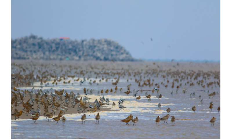
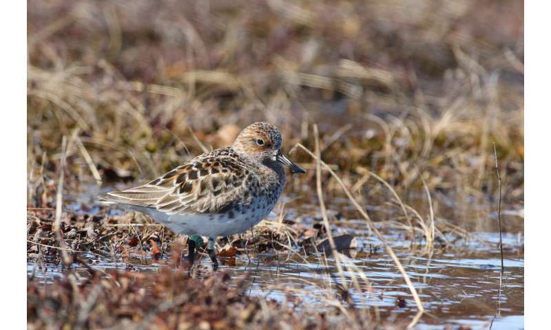
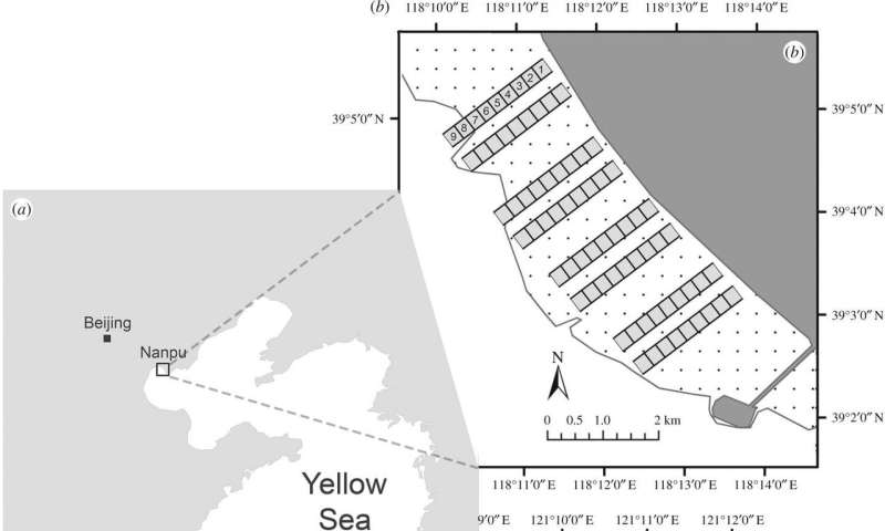
    A key difference of the Princeton research was that it included observations of the high-tide period when the middle and lower tidal flats are underwater. The researchers focused on the East Asia-Australasian Flyway, which spans from Australia to Siberia along the rapidly developing coast of China where birds stop to rest and refuel. The researchers studied birds at two well-known stopover sites in the Yellow Sea region, Nanpu (b) near Beijing and Rudong (c) outside of Shanghai. The dark squares indicate the study plots along the upper, middle and lower tidal flats (dotted area). The white areas represent the sea beyond the low-tide line. Credit: Tong Mu, Department of Ecology and Evolutionary Biology

    "This is a new insight into Asian shorebirds, but I suspect that the upper intertidal is disproportionately important to shorebirds in other places, too, such as the East and West coasts of North America," said Wilcove, who is a professor of ecology and evolutionary biology and public affairs and the Princeton Environmental Institute (PEI).
    \
    "People start at the upper zone and work their way outward, so the best spots for the birds are the first to go," he said. "It would probably be best to extend current developments farther into the intertidal zone rather than keep building parallel to the coast, which consumes more of the upper intertidal.

    "Think of it as advocating for a rectangle with the long side pointing into the sea versus a rectangle with the long side hugging the shore," Wilcove said.

    The study results also suggest that protecting species and their habitats may mean more than designating land for wildlife—it may require identifying the right land to set aside by gaining a detailed understanding of exactly how animals interact with the landscape.

    "Recognizing the importance of a kind of habitat to specific species or groups of species takes time, effort and thought," said Mu, who is the paper's first author and a Ph.D. candidate in ecology and evolutionary biology.

    "Sometimes we just don't know what to look for, or looking requires challenging some prevalent and maybe false perceptions," he said. "But the situation is getting better and better. People are paying more attention to environmental issues, and the advances in technology are helping us gain more and newer insight into these questions."

    Mu conducted fieldwork between September 2016 and May 2017 at two well-known stopover sites—one outside of Beijing, the other near Shanghai—for migratory shorebirds in the Yellow Sea region. He focused on 17 species of birds, noting where along the tidal flat the animals preferred to feed.

    The findings suggest that protecting species requires gaining a detailed understanding of exactly how animals interact with the landscape so that preserved habitats best serve endangered species' needs. Since the 1980s, the loss of tidal flats around the Yellow Sea has averaged 1.2% per year. Yet, the annual loss of the most endangered bird species has averaged between 5.1 and 7.5%, with populations of species such as the critically endangered spoon-billed sandpiper (Calidris pygmaea) climbing as high as 26% each year. Credit: Tong Mu, Department of Ecology and Evolutionary Biology

    A key difference to his approach, Mu said, is that most previous research focused on the low-tide period when all the tidal flats are exposed and the full range of intertidal species can be observed.

    "It makes sense from an ecological point of view. During the high tides when only a portion of the tidal flats is accessible, the relationship usually still holds for the exposed area," Mu said. "So, there's little incentive to look at the periods other than low tide when researchers can get a more complete picture."

    What Mu thinks was missed, however, was that the upper tidal flats provide the most amount of foraging time for birds that have places to be. Even if the lower half of a 6-mile wide mudflat is set aside for migratory birds, they're not getting the energy they need for the trip ahead during the high tide, he said.

    "The value of the tidal flats comes from not only their size, but also how much foraging time they can provide," Mu said. "The upper tidal area is exposed for a longer period during tidal cycles, compared to the middle and lower areas, which I think permits shorebirds to forage for a longer time and thus get more energy."

    The preservation of shorebirds should be driven by how integral the animals are to the health of intertidal zones, Mu and Wilcove said. In turn, tidal flats are not only vital to other marine life, but also provide people with seafood such as clams and crabs and protection from storms and storm surges that cause coastal flooding.

    "Shorebirds facilitate the energy and nutrient exchanges between land and sea," Mu said. "Because a lot of them are long-distance migrants, they also facilitate the energy and nutrient exchanges across different ecosystems and continents, something that is usually overlooked and underappreciated."

    Wilcove and Mu cited recent research showing that more than 15%, or more than 12,000 square miles, of the world's natural tidal flats were lost between 1984-2016.

    "Some of the greatest travelers on Earth are the shorebirds that migrate from Siberia to Southeast Asia and Australia," Wilcove said. "Now, they're declining in response to the loss of the tidal areas, and the full range of benefits those tidal flats provide are in some way being diminished."
    Australia migratory bird levels plunge from Asia development
    More information: Tong Mu et al, Upper tidal flats are disproportionately important for the conservation of migratory shorebirds, Proceedings of the Royal Society B: Biological Sciences (2020). DOI: 10.1098/rspb.2020.0278
    Journal information: Proceedings of the Royal Society B


    Provided by Princeton University

    Tuesday, January 07, 2025


    Sunken worlds under the Pacific?


    ETH Zurich
    Wave speed anomalies under the Western Pacific 

    image: 

    A new computer model visualizes material in the lower mantle that cannot come from subducted plates.

    view more 

    Credit: Sebastian Noe / ETH Zurich


    No one can see inside the Earth. Nor can anyone drill deep enough to take rock samples from the mantle, the layer between Earth’s core and outermost, rigid layer the lithosphere, or measure temperature and pressure there. That's why geophysicists use indirect methods to see what's going on deep beneath our feet.

    For example, they use seismograms, or earthquake recordings, to determine the speed at which earthquake waves propagate. They then use this information to calculate the internal structure of the Earth. This is very similar to how doctors use ultrasound to image organs, muscles or veins inside the body without opening it up.

    Seismic waves provide information

    Here's how it works: when the Earth trembles, seismic waves spread out from the epicentre in all directions. On their way through the Earth, they are refracted, diffracted or reflected. The speed at which the waves spread depends on the type of wave, but also on the density and elasticity of the material through which the waves pass. Seismographic stations record these different waves, and on the basis of these recordings, geophysicists can draw conclusions about the structure and composition of the Earth and examine the processes that take place inside it.

    Using seismic recordings, Earth scientists determined the position of submerged tectonic plates throughout the Earth's mantle.  They always found them where they expected them to be: in an area known as subduction zones, where two plates meet and one subducts beneath the other into the Earth's interior. This has helped scientists investigate the plate tectonic cycle, i.e., the emergence and destruction of plates at Earth’s surface, through our planet’s history. 

    Plate remnants where there shouldn't be any

    Now, however, a team of geophysicists from ETH Zurich and the California Institute of Technology has made a surprising discovery: using a new high-resolution model, they have discovered further areas in the Earth's interior that look like the remains of submerged plates. Yet, these are not located where they were expected; instead, they are under large oceans or in the interior of continents – far away from plate boundaries. There is also no geological evidence of past subduction there. This study was recently published in the journal Scientific Reports.

    What is new about their modelling approach is that the ETH researchers are not just using one type of earthquake wave to study the structure of the Earth's interior, but all of them. Experts call the procedure full-waveform inversion. This makes the model very computationally intensive, which is why the researchers used the Piz Daint supercomputer at the CSCS in Lugano. Is there a lost world beneath the Pacific Ocean?

    “Apparently, such zones in the Earth's mantle are much more widespread than previously thought,” says Thomas Schouten, first author and doctoral student at the Geological Institute of ETH Zurich.

    One of the newly discovered zones is under the western Pacific. However, according to current plate tectonic theories and knowledge, there should be no material from subducted plates there, because it is impossible that there were subduction zones nearby in the recent geological history. The researchers do not know for certain what material is involved instead, and what that would mean for Earth’s internal dynamics. “That's our dilemma. With the new high-resolution model, we can see such anomalies everywhere in the Earth's mantle. But we don't know exactly what they are or what material is creating the patterns we have uncovered.”

    It's like a doctor who has been examining blood circulation with ultrasound for decades and finds arteries exactly where he expects them, says ETH professor Andreas Fichtner. “Then if you give him a new, better examination tool, he suddenly sees an artery in the buttock that doesn't really belong there. That's exactly how we feel about the new findings,” explains the wave physicist. He developed the model in his group and wrote the code.

    Extracting more information from waves

    So far, the researchers can only speculate. “We think that the anomalies in the lower mantle have a variety of origins,” says Schouten. He believes it is possible that they are not just cold plate material that has subducted in the last 200 million years, as previously assumed. “It could be either ancient, silica-rich material that has been there since the formation of the mantle about 4 billion years ago and has survived despite the convective movements in the mantle, or zones where iron-rich rocks accumulate as a consequence of these mantle movements over billions of years” he notes.

    For the doctoral student, this means above all that more research with even better models is needed to see further details of Earth’s interior. “The waves we use for the model essentially only represent one property, namely the speed at which they travel through the Earth's interior,” says the Earth scientist. However, this does not do justice to the Earth's complex interior. “We have to calculate the different material parameters that could generate the observed speeds of the different wave types. Essentially, we have to dive deeper into the material properties behind the wave speed,” says Schouten.