Showing posts sorted by date for query LEMURIA. Sort by relevance Show all posts

Tuesday, October 24, 2023

Argoland: Unraveling the mysteries of a lost continent


10-23-2023
ByChrissy Sexton
Earth.com staff writer

Geologists have long been intrigued by a missing piece of Earth’s history – a lost continent called Argoland. Around 155 million years ago, a 5,000-kilometer chunk broke off of western Australia and began its solitary drift.

The void that was left behind is marked by a basin deep below the ocean known as the Argo Abyssal Plain. But, where did Argoland actually go?

A new study from Utrecht University reveals that while Argoland might not exist as a singular mass today, it has not vanished entirely.
The journey of Argoland

Scientists have relied on the underwater Argo Abyssal Plain as evidence of Argoland’s past existence. The seabed structure suggests that the detached continent drifted northwestward, potentially towards present-day Southeast Asia.

But the mystery deepens, as the vast continent-sized footprint of Argoland is conspicuously absent beneath Southeast Asian islands. Instead, these islands sit atop smaller continental fragments, encircled by significantly older oceanic basins.

This led geologists to dive deeper into the fate of Argoland. They found that the lost continent hasn’t completely disappeared – it has simply shattered into fragments.
Earth’s hidden tales

Earth’s crust varies in weight, comprising heavier oceanic sections and lighter continental chunks. Interestingly, these lighter portions might be lurking below sea level, much like Greater Adria, another lost continent.

Greater Adria’s journey ended when it submerged into the Earth’s mantle, leaving its top layer behind, which later morphed into the mountains of Southern Europe. Argoland, by contrast, left no evidence in the form of folded rocks.
Study significance

Utrecht University geologist Douwe van Hinsbergen emphasized the significance of tracing these continents.

“If continents can dive into the mantle and disappear entirely, without leaving a geological trace at the Earth’s surface, then we wouldn’t have much of an idea of what the Earth could have looked in the geological past. It would be almost impossible to create reliable reconstructions of former supercontinents and the Earth’s geography in foregone eras,” said van Hinsbergen.

“Those reconstructions are vital for our understanding of processes like the evolution of biodiversity and climate, or for finding raw materials. And at a more fundamental level: for understanding how mountains are formed or for working out the driving forces behind plate tectonics; two phenomena that are closely related.”
Islands of information

Van Hinsbergen and his colleague Eldert Advokaat were curious about what the geology of Southeast Asia may reveal about Argoland.

“But we were literally dealing with islands of information, which is why our research took so long. We spent seven years putting the puzzle together,” said Advokaat.

“The situation in Southeast Asia is very different from places like Africa and South America, where a continent broke neatly into two pieces. Argoland splintered into many different shards. That obstructed our view of the continent’s journey.”

Fragmented continent

But then, Advokaat realized that these fragments converged at their current locations simultaneously, painting a once cohesive picture. Today, the remnants of Argoland can be found beneath the jungles of Indonesia and Myanmar.

This fragmentation was characteristic. Argoland was never a single, solid landmass. Instead, it was an ‘Argopelago,’ a collection of microcontinental chunks interspersed with older oceanic basins. This aspect aligns with other known entities like Greater Adria and Zeelandia.

An evolving planet

The investigation by Advokaat and Van Hinsbergen seamlessly links the geological systems between the Himalayas and the Philippines. Their explorations unravel why Argoland fragmented so intensely.

Around 215 million years ago, the continent underwent rapid fracturing, breaking into slender splinters. This theory was further supported through field studies on islands such as Sumatra, Borneo, and Timor.

The story of Argoland is not one of complete disappearance but of transformation. As the world continues to evolve, this lost continent serves as a compelling reminder of the ever-shifting nature of our planet.

The study is published in the journal Gondwana Research.


GONDWANA’S SECRET: 390-MILLION-YEAR-OLD MARINE MYSTERY UNRAVELED

2023-10-23 02:24 PM by Daisy Hips


During the Early-Middle Devonian, Gondwana was a warm, flooded landmass at the South Pole, home to the now-extinct Malvinoxhosan biota. New research has revealed these species’ decline correlated with sea-level and temperature changes. Their extinction, likely due to disrupted ocean barriers and an influx of warm-water species, led to an irreversible collapse of polar ecosystems. Similar patterns have been observed in South America, underscoring the lasting sensitivity of polar regions to environmental shifts.

During the Early-Middle Devonian period, a large landmass called Gondwana—which included parts of today’s Africa, South America, and Antarctica—was located near the South Pole. Contrary to the frosty environment we see today, the climate was warmer, and elevated sea levels submerged much of its terrain.

THE MALVINOXHOSAN BIOTA MYSTERY


The Malvinoxhosan biota were a group of marine animals that thrived in cooler waters. They included various types of shellfish, many of which are now extinct. “The origin and disappearance of these animals have remained an enigma for nearly two centuries until now,” says Dr. Penn-Clarke.

The researchers collected and analyzed a vast amount of fossil data. They used advanced data analysis techniques to sort through layers of ancient rock based on the types of fossils found in them. Imagine it like sorting through layers of a cake, each with different ingredients.

Simplified diagram showing the relationship between changes in sea-level and environment with biodiversity through time in South Africa during the Early-Middle Devonian. Credit: GENUS: DSI-NRF Centre of Excellence in Palaeosciences

They then identified at least 7 to 8 distinct layers, each showing fewer and fewer types of marine animals over time. These findings were then compared with how the environment and sea levels have changed, as well as with global temperature records from that ancient period. They found that these marine animals went through several phases of declining numbers of different species, which correlated with changes in sea levels and climate. It was a difficult process.

“This research is around 12-15 years in the making, and it wasn’t an easy journey,” shares Dr. Penn-Clarke. “I was only able to overcome all the different challenges through dogged persistence and perseverance.”

THEORIES ON MARINE LIFE ADAPTATION


Their research suggests that the Malvinoxhosan biota survived during a long period of global cooling. Dr. Penn-Clarke elaborates, “We think that cooler conditions allowed for the creation of circumpolar thermal barriers—essentially, ocean currents near the poles—that isolated these animals and led to their specialization.”

As the climate warmed up again, these animals disappeared. They were replaced by more generalist marine species that are well-adapted to warmer waters. Shifts in sea levels during the Early-Middle Devonian period probably disrupted natural ocean barriers that had kept waters cooler at the South Pole.

Inset images are of common invertebrate fossils found in South Africa. Clockwise from left: Brachiopod shell bed of Australospirifer and Australocoelia, the trilobite Eldredgeia, brachiopod shells of Rhipidothyris, an ophiuroid bed. At centre is an enrolled trilobite assigned to Burmiesteria. Image credits: Geographic reconstruction after Penn-Clarke and Harper (2023), fossil photographs by Cameron Penn-Clarke and John Almond. Credit: GENUS: DSI-NRF Centre of Excellence in Palaeosciences

This allowed warmer waters from regions closer to the equator to flow in, setting the stage for marine animals that thrive in warmer conditions to move into these areas. As a result, these warm-water species gradually took over, leading to the decline and eventual disappearance of the specialized, cool-water Malvinoxhosan marine animals.

IMPACT ON POLAR ECOSYSTEMS

The extinction of the Malvinoxhosan biota led to a complete collapse in polar ecosystems, as biodiversity in these regions never recovered.

“This suggests a complete collapse in the functioning of polar environments and ecosystems to the point that they could never recover,” Dr. Penn-Clarke adds.

He likens this research to playing a game of Clue.

“It’s a 390-million-year-old murder mystery. We now know that the combined effects of changes in sea level and temperature were the most likely ‘smoking gun’ behind this extinction event,” he notes. It is still unknown if this extinction event can be correlated with known extinction events at the same time elsewhere during the Early-Middle Devonian as researchers simply do not have any real good age inferences. The mystery deepens further, and it is far from over.

Interestingly, similar declines in biodiversity controlled by sea-level changes have been observed in South America. This points to a broader pattern of environmental change affecting the South Polar region during this period and underscores the vulnerability of polar ecosystems, even in the past.

“This research is important when we consider the biodiversity crisis we are facing in the present day,” says Dr. Penn-Clarke. “It demonstrates the sensitivity of polar environments and ecosystems to changes in sea level and temperature. Any changes that occur are, unfortunately, permanent.”

Reference: “The rise and fall of the Malvinoxhosan (Malvinokaffric) bioregion in South Africa: Evidence for Early-Middle Devonian biocrises at the South Pole” by Cameron R. Penn-Clarke and David A.T. Harper, 13 October 2023, Earth-Science Reviews.
DOI: 10.1016/j.earscirev.2023.104595

The study was funded by the GENUS: DSI-NRF Centre of Excellence in Palaeosciences, the National Research Foundation, and the Leverhulme Trust.


Saturday, August 19, 2023

A dramatic volcano eruption changed lives in Fiji 2,500 years ago—100 generations have kept the story alive

by Patrick D. Nunn, The Conversation
The hole made when a spear was thrown by one god at the other, on the north coast of eastern Kadavu. 
Credit: Patrick D. Nunn CC BY-ND.

Can you imagine a scientist who could neither read nor write, who spoke their wisdom in riddles, in tales of fantastic beings flying through the sky, fighting each another furiously and noisily, drinking the ocean dry, and throwing giant spears with force enough to leave massive holes in rocky headlands?

Our newly published research in the journal Oral Tradition shows memories of a volcanic eruption in Fiji some 2,500 years ago were encoded in oral traditions in precisely these ways.


They were never intended as fanciful stories, but rather as the pragmatic foundations of a system of local risk management.

Life-changing events


Around 2,500 years ago, at the western end of the island of Kadavu in the southern part of Fiji, the ground shook, the ocean became agitated, and clouds of billowing smoke and ash poured into the sky.

When the clouds cleared, the people saw a new mountain had formed, its shape resembling a mound of earth in which yams are grown. This gave the mountain its name—Nabukelevu, the giant yam mound. (It was renamed Mount Washington during Fiji's colonial history.)

So dramatic, so life-changing were the events associated with this eruption, the people who witnessed it told stories about it. These stories have endured more than two millennia, faithfully passed on across roughly 100 generations to reach us today.

Scientists used to dismiss such stories as fictions, devalue them with labels like "myth" or "legend". But the situation is changing.

Today, we are starting to recognize that many such "stories" are authentic memories of human pasts, encoded in oral traditions in ways that represent the worldviews of people from long ago.

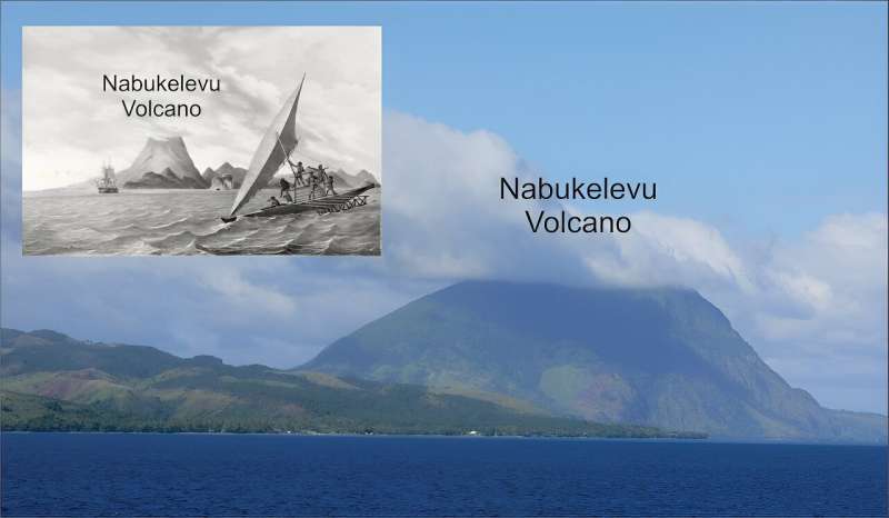
Nabukelevu from the northeast, its top hidden in cloud. Inset: Nabukelevu from the west in 1827 after the drawing by the artist aboard the Astrolabe, the ship of French explorer Dumont d’Urville. It is an original lithograph by H. van der Burch after original artwork by Louis Auguste de Sainson. Credit: Wikimedia Commons; Australian National Maritime Museum,
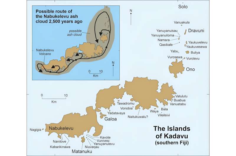
 CC BY-SA

In other words, these stories served the same purpose as scientific accounts, and the people who told them were trying to understand the natural world, much like scientists do today.

Battle of the vu


The most common story about the 2,500-year-old eruption of Nabukelevu is one involving a "god" (vu in Fijian) named Tanovo from the island of Ono, about 56km from the volcano.

Tanovo's view of the sunset became blocked one day by this huge mountain. Our research identifies this as a volcanic dome that was created during the eruption, raising the height of the mountain several hundred feet.

Enraged, Tanovo flew to Nabukelevu and started to tear down the mountain, a process described by local residents as driva qele (stealing earth). This explains why even today the summit of Nabukelevu has a crater.

But Tanovo was interrupted by the "god" of Nabukelevu, named Tautaumolau. The pair started fighting. A chase ensued through the sky and, as the two twisted and turned, the earth being carried by Tanovo started falling to the ground, where it is said to have "created" islands.

We conclude that the sequence in which these islands are said to have been created is likely to represent the movement of the ash plume from the eruption, as shown on the map below.

'Myths' based in fact


Geologists would today find it exceedingly difficult to deduce such details of an ancient eruption. But here, in the oral traditions of Kadavu people, this information is readily available.


Smaller offshore islands named in seven versions of the Nabukelevu story as having formed following the Nabukelevu eruption. Inset shows the possible trace of the ash cloud based on the stories. Credit: Patrick D. Nunn, CC BY-ND.

Another detail we would never know if we did not have the oral traditions is about the tsunami the eruption caused.

In some versions of the story, one of the "gods" is so frightened, he hides beneath the sea. But his rival comes along and drinks up all the water at that place, a detail our research interprets as a memory of the ocean withdrawing prior to tsunami impact.

Other details in the oral traditions recall how one god threw a massive spear at his rival but missed, leaving behind a huge hole in a rock. This is a good example of how landforms likely predating the eruption can be retrofitted to a narrative.

Our study adds to the growing body of scientific research into "myths" and "legends", showing that many have a basis in fact, and the details they contain add depth and breadth to our understanding of human pasts.

The Kadavu volcano stories discussed here also show ancient societies were no less risk aware and risk averse than ours are today. The imperative was to survive, greatly aided by keeping alive memories of all the hazards that existed in a particular place.

Australian First Peoples' cultures are replete with similar stories.


Literate people, those who read and write, tend to be impressed by the extraordinary time depth of oral traditions, like those about the 2,500-year old eruption of Nabukelevu. But not everyone is.

In early 2019, I was sitting and chatting to Ratu Petero Uluinaceva in Waisomo Village, after he had finished relating the Ono people's story of the eruption. I told him this particular story recalled events which occurred more than two millennia ago—and thought he might be impressed. But he wasn't.

"We know our stories are that old, that they recall our ancient history," he told me with a grin. "But we are glad you have now learned this too!"


Provided by The Conversation

This article is republished from The Conversation under a Creative Commons license. Read the original article.


Explore furtherEvidence the oral stories of Australia's First Nations might be 10,000 years old


SEE


  • James Churchward - Wikipedia

    https://en.wikipedia.org/wiki/James_Churchward

    James Churchward (27 February 1851 – 4 January 1936) was a British occult writer, inventor, engineer, and fisherman. Churchward is most notable for proposing the existence of a lost continent, called "Mu," in the Pacific Ocean. His writings on Mu are considered to be pseudoscience.

    Churchward was born in Bridestow, Okehampton, Devon at Stone House to Henry and Matilda (née Gould) Churchward. James had four brothers and four sisters. In November 1854, Henry died and the family moved in with Matilda's parents in the hamlet of Kigbear, near Okehampton. Census records indicate the family next moved to London when James was 18 after his grandfather George Gould died. 

    Wikipedia · Text under CC-BY-SA license
  • THE SACRED SYMBOLS OF MU - James Churchward

    www.bahaistudies.net/.../Col-James-Churchward-The-Sacred-Symbol… · PDF file

    COLONEL JAMES CHURCHWARD AUTHOR OF "THE LOST CONTINENT OF MU" "THE CHILDREN OF MU" ILLUSTRATED IVES WASHBURN; NEW YORK Scanned at sacred-texts.com, December, 2003.

  • 3 Beards Podcast: Is the Lost Continent of Mu Real?

    Author Jack Churchward joins the show to talk about his books that cover The Lost Continent of Mu, a subject brought to life by the works of his great grandfather Col. James Churchward.

    Lifting the Veil on the Lost Continent of Mu: The Motherland of Men
    The Stone Tablets of Mu
    Crossing the Sands of Time
    are books Jack Churchward has penned to cover the works of his great grandfather and bring into focus on what is fact and what is fiction.

    The mythical idea of the “Land of Mu” first appeared in the works of the British-American antiquarian Augustus Le Plongeon (1825–1908), after his investigations of the Maya ruins in Yucatán. He claimed that he had translated the first copies of the Popol Vuh, the sacred book of the K’iche’ from the ancient Mayan using Spanish. He claimed the civilization of Yucatán was older than those of Greece and Egypt, and told the story of an even older continent.

    Col. James Churchward claimed that the landmass of Mu was located in the Pacific Ocean, and stretched east–west from the Marianas to Easter Island, and north–south from Hawaii to Mangaia. According to Churchward the continent was supposedly 5,000 miles from east to west and over 3,000 miles from north to south, which is larger than South America. The continent was believed to be flat with massive plains, vast rivers, rolling hills, large bays, and estuaries. He claimed that according to the creation myth he read in the Indian tablets, Mu had been lifted above sea level by the expansion of underground volcanic gases. Eventually Mu “was completely obliterated in almost a single night” after a series of earthquakes and volcanic eruptions, “the broken land fell into that great abyss of fire” and was covered by “fifty millions of square miles of water.” Churchward claimed the reasoning for the continent’s destruction in one night was because the main mineral on the island was granite and was honeycombed to create huge shallow chambers and cavities filled with highly explosive gases. Once the chambers were empty after the explosion, they collapsed on themselves, causing the island to crumble and sink.


    Rising seas and a great southern star: Aboriginal oral traditions stretch back more than 12,000 years

    Rising seas and a great southern star: Aboriginal oral traditions stretch back more than 12,000 years
    Credit: Shutterstock

    How long do you think stories can be passed down, generation to generation?

    Hundreds of years? Thousands?

    Today, we publish new research in the Journal of Archaeological Science demonstrating that traditional stories from Tasmania have been passed down for more than 12,000 years. And we use multiple lines of evidence to show it.

    Tasmania's violent colonial history

    Within months of establishing a colonial outpost on the island in 1803, British officials had committed several acts of genocide against Aboriginal Tasmanian (Palawa) people. By the mid-1820s, soldiers, convicts, and free settlers had taken up arms to fight what became known as the "Black War", aimed at capturing or killing Palawa and dispossessing them of their Country.

    Tasmania's colonial government appointed George Augustus Robinson to "conciliate" with the Palawa. From 1829 to 1835, Robinson traveled with a small group of Palawa, including Trukanini and her husband, Wurati. By 1832, Robinson's "friendly mission" had turned to forced removals.

    Robinson kept a daily journal, which included records of Palawa languages and traditions. Over time, Palawa men and women slowly began to share some of their knowledge, explaining how their ancestors came to Tasmania (Lutruwita) by land from the far north, before the sea formed and turned their home into an island. They also spoke about the Sun-man, the Moon-woman, and a bright southern star.

    Rising seas and a great southern star: Aboriginal oral traditions stretch back more than 12,000 years
    A topographic map of the Bass Strait, showing the conditions before the Bassian Land 
    Bridge was submerged. The yellow shaded area represents geography of the land bridge,
     while the broken red line indicated the last vestige of a continuous Bassian Land Bridge 
    between Tasmania and the mainland. Credit: Patrick Nunn, Author provided

    These stories are of immense importance to today's Palawa families who survived the devastating impact of colonization, and who continue to share these unique creation stories. Through careful investigation of colonial records, and collaborating with Palawa knowledge-holders, we found something remarkable.

    Rising seas and the formation of Lutruwita

    Over the past 65,000 years, Australia's First Peoples witnessed  and significant changes to the land, sea and sky. Volcanoes spewed fire, earthquakes shook the land, tsunamis inundated the coastlines, droughts plagued the continent, meteorites fell to the earth, and the stars shifted in the night sky.

    Some 20,000 years ago, the world was in the grip of an ice age. Australia was conspicuously drier than it is today, and the ocean was significantly lower. All of that sea water was bound up in glaciers that swathed vast tracts of land, particularly across the Northern Hemisphere, and polar ice caps much larger than ours today.

    As time passed, temperatures gradually rose and the ice began to melt. After 10,000 years, the sea level had risen 125 meters; a process that dramatically transformed coastlines and submerged landscapes that had been ancestral Country for thousands of generations. This forced humans to change where and how they lived.

    During the ice age, both Lutruwita and Papua New Guinea were connected to mainland Australia by dry land, forming a landmass called Sahul. As the seas rose, Tasmania's connection gradually narrowed to form what geologists call the Bassian Land Bridge.

    People continued to live on this "", but by 12,700 years ago it had narrowed to just 5 kilometers wide (lime-green shading on the map above). Habitable land was gradually reduced as the sea closed in. Less than 300 years later, the "land bridge" was gone and Lutruwita was completely surrounded by water.

    Palawa traditions from that time survived hundreds of generations of retelling, forming part of a larger canon of Aboriginal and Torres Strait Islander stories around Australia. They described rising seas and submerging coastlines as the ice sheets melted before leveling off around 7,000 years ago. Stories of similar antiquity are known from other parts of the world.

    A great south star

    Aboriginal and Torres Strait Islander cultures developed rich and complex knowledge systems about the stars, which are still used today. They describe the movements of the Sun, Moon, and stars, as well as rare cosmic events, such as eclipses, supernovae, and meteorite impacts.

    In the 1830s, a Palawa Elder spoke about a time when the star Moinee was near the south celestial pole. He laid down a pair of spears in the sand and drew a few reference stars to triangulate its position.

    Colonists seemed perplexed about the presence of an antipodean counterpart to Polaris, as no southern pole star exists today. Some tried to identify the stars on the star map, but seemed confused and labeled them incorrectly, as they were unaware of an important astronomical process called axial precession.

    Rising seas and a great southern star: Aboriginal oral traditions stretch back more than 12,000 years
    Stars in the southern sky as they would have appeared 14,000 years ago, accounting for 
    precession, nutation, and proper motion. Canopus is very close to the south celestial pole
     (SCP). Credit: StellariumCC BY

    As the Earth rotates, it wobbles on its axis like a spinning top. This shifts the location of the celestial poles, tracing out a large circle every 26,000 years. As thousands of years pass by, the positions of the stars in the sky slowly change.

    Long ago, Canopus was at its southernmost point in the sky. Lying just over 10 degrees from the south celestial pole, it appeared to always hover in the southern skies each night. That last occurred 14,000 years ago, before rising seas turned Lutruwita into an island.

    Exciting collaborative futures

    We can see through independent lines of evidence that Palawa stories have been passed down for more than twelve millennia. We also find here the only example in the world of an oral tradition describing a star's position as it would have appeared in the sky over 10,000 years ago.

    Our investigation of colonial records that record traditional systems of knowledge has demonstrated a powerful cross-cultural way of better understanding deep human history. This also recognizes the immense value of Aboriginal and Torres Strait Islander traditions today.

    More information: Duane Hamacher et al, The archaeology of orality: Dating Tasmanian Aboriginal oral traditions to the Late Pleistocene, Journal of Archaeological Science (2023). DOI: 10.1016/j.jas.2023.105819

    Journal information: Journal of Archaeological Science 


    Provided by The Conversation 


    This article is republished from The Conversation under a Creative Commons license. Read the original article.The ConversationEvidence the oral stories of Australia's First Nations might be 10,000 years old  


    SEE

  • James Churchward - Wikipedia

    https://en.wikipedia.org/wiki/James_Churchward

    James Churchward (27 February 1851 – 4 January 1936) was a British occult writer, inventor, engineer, and fisherman. Churchward is most notable for proposing the existence of a lost continent, called "Mu," in the Pacific Ocean. His writings on Mu are considered to be pseudoscience.

    Churchward was born in Bridestow, Okehampton, Devon at Stone House to Henry and Matilda (née Gould) Churchward. James had four brothers and four sisters. In November 1854, Henry died and the family moved in with Matilda's parents in the hamlet of Kigbear, near Okehampton. Census records indicate the family next moved to London when James was 18 after his grandfather George Gould died. 

    Wikipedia · Text under CC-BY-SA license
  • THE SACRED SYMBOLS OF MU - James Churchward

    www.bahaistudies.net/.../Col-James-Churchward-The-Sacred-Symbol… · PDF file

    COLONEL JAMES CHURCHWARD AUTHOR OF "THE LOST CONTINENT OF MU" "THE CHILDREN OF MU" ILLUSTRATED IVES WASHBURN; NEW YORK Scanned at sacred-texts.com, December, 2003.

  • 3 Beards Podcast: Is the Lost Continent of Mu Real?

    Author Jack Churchward joins the show to talk about his books that cover The Lost Continent of Mu, a subject brought to life by the works of his great grandfather Col. James Churchward.

    Lifting the Veil on the Lost Continent of Mu: The Motherland of Men
    The Stone Tablets of Mu
    Crossing the Sands of Time
    are books Jack Churchward has penned to cover the works of his great grandfather and bring into focus on what is fact and what is fiction.

    The mythical idea of the “Land of Mu” first appeared in the works of the British-American antiquarian Augustus Le Plongeon (1825–1908), after his investigations of the Maya ruins in Yucatán. He claimed that he had translated the first copies of the Popol Vuh, the sacred book of the K’iche’ from the ancient Mayan using Spanish. He claimed the civilization of Yucatán was older than those of Greece and Egypt, and told the story of an even older continent.

    Col. James Churchward claimed that the landmass of Mu was located in the Pacific Ocean, and stretched east–west from the Marianas to Easter Island, and north–south from Hawaii to Mangaia. According to Churchward the continent was supposedly 5,000 miles from east to west and over 3,000 miles from north to south, which is larger than South America. The continent was believed to be flat with massive plains, vast rivers, rolling hills, large bays, and estuaries. He claimed that according to the creation myth he read in the Indian tablets, Mu had been lifted above sea level by the expansion of underground volcanic gases. Eventually Mu “was completely obliterated in almost a single night” after a series of earthquakes and volcanic eruptions, “the broken land fell into that great abyss of fire” and was covered by “fifty millions of square miles of water.” Churchward claimed the reasoning for the continent’s destruction in one night was because the main mineral on the island was granite and was honeycombed to create huge shallow chambers and cavities filled with highly explosive gases. Once the chambers were empty after the explosion, they collapsed on themselves, causing the island to crumble and sink.


    Monday, April 24, 2023

    The Bizarre Tale Of Lemuria: A Long-Lost Continent Inspired By Lemurs

    An Atlantis for lemurs? It's not quite as crazy as it sounds.


    TOM HALE
    Senior Journalist
    March 17, 2023
    IFLSCIENCE


    An artist's impression of Lemuria, complete with lemurs, from 1893. Image credit: Édouard Riou/New York Public Library/No Known Copyright.


    In the 19th century, a rumor circulated in the scientific world that a "lost continent" was laying undiscovered at the bottom of the Indian Ocean. They named it Lemuria as their misguided efforts were driven by some very confusing lemurs.

    The idea is largely credited to British zoologist Philip Lutley Sclater who wrote a paper titled “The Mammals of Madagascar” in 1864, published in the Quarterly Journal of Science. Sclater explained that lemur fossils could be found in Madagascar and India, but not in Africa or the Middle East, suggesting that Madagascar and India were once been part of a larger continent that’s since gone missing in the Indian Ocean.

    Sclater wasn’t alone in his dreams of Lemuria and a number of other prominent European scientists jumped on the bandwagon.

    In 1868, German biologist Ernst Haeckel published “The History of Creation,” in which he argued the origin of humanity was to be found in Asia, not Africa as Charles Darwin correctly stated, and that humans were closely related to the primates of Southeast Asia.

    The "missing link, " he believed, could be found on the long-lost landmass of Lemuria. Acting as a continental superhighway between India and Africa, Lemuria could explain how humans migrated to the rest of the world, at least in his mind.

    That’s right: according to Haeckel, we are descended from lemurs and the remains of some strange lemur-human hybrids are likely to be lurking in the Indian Ocean on a long-lost continent
    .


    The (nonsense) map explains the 12 varieties of men emerging from Lemuria and migrating all over the Earth. Image credit: Library of Congress/Public Domain

    Another equally eccentric idea came from Helena Blavatsky, a 19th-century Russian mystic whose work is teeming with bizarre pseudo-science and mysticism. In her 1888 book, The Secret Doctrine, she promoted the ridiculous idea that all of humanity is descended from seven "root races." One of these was from Atlantis, and one was apparently from the continent of Lemuria, which she placed somewhere in the Pacific Ocean.

    As wild as the idea of Lemuria may sound, it’s not totally baseless.

    The theory gained a bit of traction in the 19th century because this was long before the discovery of plate tectonics and "continental drift", which explained how the world’s continents are constantly (and very slowly) drifting around the planet.

    It turned out, the theory that India and Africa were once joined was true. Until around 200 million years ago, all of Earth's continents were once smooshed together in one supercontinent, Pangaea. In this configuration, the Indian Plate was tucked up close to the east of the Africa plate.

    Furthermore, there was genuinely a microcontinent called Mauritia that was located between India and Madagascar until their separation about 70 million years ago.

    In 2017, scientists confirmed the existence of the "lost continent" by finding evidence of a piece of continental crust under the island of Mauritius in the Indian Ocean. Their work indicated that this chip of ancient continent likely broke off from the island of Madagascar, when Africa, India, Australia, and Antarctica split up.

    Unfortunately, however, lemurs had little to do with any of it.


    Everything You Need To Know About Lemuria, The Lost Continent Of Lemurs

    By Esther Inglis-Arkell
    Published August 21, 2014

    In 1858 a young zoologist, playing around with an idea, came up with a possible lost continent. This led to one of the longest and weirdest pseudoscience theories of all time, as Lemuria became a lost island of lemurs that had everything from sanskrit to sasquatch.

    This was thanks to Philip Lutley Sclater, who has plenty of less crazy credits to his name. He amassed a collection of thousands of bird specimens, which he gave to the British museum. He described the okapi to western zoologists. He founded The Ibis, a journal of ornithology. And he fathered a son, who grew to be another respected ornithologist. But in 1858, when Sclater was in his 20s and all the crazy young kids were coming up with tales of land bridges and lost continents, he undertook a study of the fauna of Madagascar. Sclater with struck by the fact that Madascar's ecology was similar not only to Africa but to India as well. Sclater's conclusion, drawn from the puzzling similarity, was that both continents had once been connected by a lost land called Lemuria.

    The world hadn't arrived at the theory of continental drift just yet, but scientists studying the geology, zoology, and botany of different continents had noticed some links and uncanny coincidences. They came up with all kind of possible connections between continents, and Lemuria, a lost continent of lemurs, was Sclater's contribution. He wasn't alone. If he had been, Lemuria would have faded into obscurity; Ernst Haeckel, a Darwin enthusiast often credited with promoting Darwin's ideas of natural selection in Germany, also came up with the idea of Lemuria. He added his own spin on it, claiming that Lemurians were not just lemurs, but humans as well. The Lemurians migrated to India as their continent sank, Haeckel claimed, and became the Aryans.

    Once Lemuria was connected to a mythical human race, everyone had a theory about it. Helena Blavatsky, noted cult leader and nutbag , claimed that the Lemurians were actual human-sized lemurs. They were "hermaphrodites," she said, that reproduced without sexual intercourse, until they discovered sex, and their wickedness made their continent sink into the sea. People believed that the Lemurians came up with Sanskrit, that they were telepathic, that they were unable to reason but lived happily by instinct alone. Herbert Spencer Lewis, a member of the Rosicrucians, published a book claiming that the Lemurians were actually ancestors of the Maya. (Though how they got from India and Africa to Central America was anyone's guess.) Furthermore, he believed that the last pure Lemurians lived in secret on top of Mount Shasta, in California. (Again, no word on their mode of transportation.) Hikers, he said, sometimes spotted them, as they had long hair and English accents. (Seriously. These people got around.)

    Lemurian legends spring up to this day, and have less and less to do with lemurs. Sclater would not approve.

    [Via Bogus Science]


    Scientific American
    https://blogs.scientificamerican.com › a-geologists-dre...
    May 10, 2013 — "The probable primeval home or "Paradise" is here assumed to be Lemuria, a tropical continent at present lying below the level of the Indian ...

    BEST BOOK ON THE SUBJECT AS IT RELATES TO TAMIL LEGENDS
    by S Ramaswamy ·  During the nineteenth century, Lemuria was imagined as a land that once bridged India and Africa but disappeared into the ocean millennia ago, ...

    by S Ramaswamy1999Cited by 36 — While the many written texts on Lemuria narrate catastrophic stories of its violent dismemberment and disappearance, the maps accompanying these narratives ...